

List of Pennsylvania state historical markers in Bucks County
Encyclopedia
This is intended to be a complete list of the official state historical markers placed in Bucks County, Pennsylvania
Bucks County, Pennsylvania
- Industry and commerce :The boroughs of Bristol and Morrisville were prominent industrial centers along the Northeast Corridor during World War II. Suburban development accelerated in Lower Bucks in the 1950s with the opening of Levittown, Pennsylvania, the second such "Levittown" designed by...
by the Pennsylvania Historical and Museum Commission
Pennsylvania Historical and Museum Commission
The Pennsylvania Historical and Museum Commission is the governmental agency of the Commonwealth of Pennsylvania responsible for the collection, conservation and interpretation of Pennsylvania's historic heritage...
(PHMC). The locations of the historical markers, as well as the latitude and longitude coordinates as provided by the PHMC's database, are included below when available. There are 79 historical markers located in Bucks County.
Historical markers
| Marker title | Image | Date dedicated | Location | Marker type | Topics |
|---|---|---|---|---|---|
| Aaron Siskind Aaron Siskind Aaron Siskind was an American abstract expressionist photographer. In his biography he wrote that he began his foray into photography when he received a camera for a wedding gift and began taking pictures on his honeymoon. He quickly realized the artistic potential this offered... (1903-1991) |
28 E. Swamp Rd. (Pa. 313) east of Pa. 611, Doylestown (Cross Keys) 40.327°N 75.12755°W |
Roadside | Artists, Professions & Vocations | ||
| Abraham Lincoln Abraham Lincoln Abraham Lincoln was the 16th President of the United States, serving from March 1861 until his assassination in April 1865. He successfully led his country through a great constitutional, military and moral crisis – the American Civil War – preserving the Union, while ending slavery, and... |
Near intersection of Bristol Pike & Pond St., Bristol °N °W |
City | Abraham Lincoln, Government & Politics, Government & Politics 19th Century | ||
| Andalusia Andalusia (estate) Andalusia, also known as the Nicholas Biddle Estate, is a historic mansion and surrounding estate located on the Delaware River just north of Philadelphia in the village named Andalusia for it in Bensalem Township, Bucks County, Pennsylvania.... |
,_andalusia_(bucks_county,_pennsylvania).jpg) |
1237 State Road, Andalusia (Bensalem Township) 40.0656°N 74.9618°W |
Roadside | Agriculture, Buildings, Business & Industry, Government & Politics, Government & Politics 19th Century, Professions & Vocations, Writers | |
| Bogart's Tavern | Route 263 and Route 413, Buckingham 40.32357°N 75.06042°W |
City | American Revolution, Government & Politics, Military, Inns & Taverns | ||
| Bristol Bristol Bristol is a city, unitary authority area and ceremonial county in South West England, with an estimated population of 433,100 for the unitary authority in 2009, and a surrounding Larger Urban Zone with an estimated 1,070,000 residents in 2007... |
n/a | Old U.S. 13 SR 2002 (Missing) °N °W |
Roadside | Cities & Towns, Early Settlement, Government & Politics | |
| Bristol Bristol Bristol is a city, unitary authority area and ceremonial county in South West England, with an estimated population of 433,100 for the unitary authority in 2009, and a surrounding Larger Urban Zone with an estimated 1,070,000 residents in 2007... |
Old US 13 at Otter Rd., S of Bristol 40.09717°N 74.87041°W |
Roadside | Cities & Towns, Early Settlement, Government & Politics 17th Century, Transportation | ||
| Bristol Bristol Bristol is a city, unitary authority area and ceremonial county in South West England, with an estimated population of 433,100 for the unitary authority in 2009, and a surrounding Larger Urban Zone with an estimated 1,070,000 residents in 2007... |
n/a | Old U.S. 13 N of Bristol (Missing) °N °W |
Roadside | Cities & Towns | |
| Buckingham Meeting House Buckingham Friends Meeting House Buckingham Friends Meeting House, in Buckingham Township, Pennsylvania, built in 1768, is nationally significant as a model for other Friends Meeting Houses.It was declared a National Historic Landmark in 2003.... |
U.S. 202 NE of Buckingham (Missing) °N °W |
Roadside | American Revolution, Buildings, Houses & Homesteads, Military, Religion | ||
| Bucks County Bucks County, Pennsylvania - Industry and commerce :The boroughs of Bristol and Morrisville were prominent industrial centers along the Northeast Corridor during World War II. Suburban development accelerated in Lower Bucks in the 1950s with the opening of Levittown, Pennsylvania, the second such "Levittown" designed by... |
Courthouse, E. Court St., Doylestown 40.31203°N 75.12965°W |
City | Government & Politics, Government & Politics 17th Century, William Penn | ||
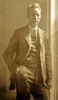
| Casimir Sienkiewicz Casimir Sienkiewicz Casimir Anthony Sienkiewicz was a prominent American economist and banker who emigrated from Poland in 1906... (1890-1974) |
202 E. Court St., Doylestown 40.31442°N 75.12687°W |
Roadside | Artists, Business & Industry, Ethnic & Immigration | ||
| Charles Sheeler Charles Sheeler Charles Rettew Sheeler, Jr. was an American artist. He is recognized as one of the founders of American modernism and one of the master photographers of the 20th century.-Early life and career:... |
 |
39 Mercer Ave. at Center St., Doylestown 40.32555°N 75.12733°W |
City | Artists | |
| Delaware Canal Pennsylvania Canal (Delaware Division) The Delaware Division of the Pennsylvania Canal, more commonly called the Delaware Canal, runs from the Lehigh River at Easton south to Bristol... |
Pa. 32 near marker 894 (Missing) °N °W |
Roadside | Canals, Navigation, Transportation | ||
| Delaware Canal Pennsylvania Canal (Delaware Division) The Delaware Division of the Pennsylvania Canal, more commonly called the Delaware Canal, runs from the Lehigh River at Easton south to Bristol... |
U.S. 13 at Bristol, South Side (Missing) °N °W |
Roadside | Canals, Navigation, Transportation | ||
| Delaware Canal Pennsylvania Canal (Delaware Division) The Delaware Division of the Pennsylvania Canal, more commonly called the Delaware Canal, runs from the Lehigh River at Easton south to Bristol... |
U.S. 13 at Bristol, North Side (Missing) °N °W |
Roadside | Canals, Navigation, Transportation | ||
| Delaware Canal Pennsylvania Canal (Delaware Division) The Delaware Division of the Pennsylvania Canal, more commonly called the Delaware Canal, runs from the Lehigh River at Easton south to Bristol... |
Pa. 611 at Durham Furnace °N °W |
Roadside | Canals, Navigation, Transportation | ||
| Delaware Canal Pennsylvania Canal (Delaware Division) The Delaware Division of the Pennsylvania Canal, more commonly called the Delaware Canal, runs from the Lehigh River at Easton south to Bristol... |
near covered bridge on Uhlerstown Hill Rd., ~ 1/4 mile west of Pa. 32 at Uhlerstown °N °W |
Roadside | Canals, Navigation, Transportation | ||
| Delaware Canal Pennsylvania Canal (Delaware Division) The Delaware Division of the Pennsylvania Canal, more commonly called the Delaware Canal, runs from the Lehigh River at Easton south to Bristol... |
Pa. 32 at Tinicum (Missing) °N °W |
Roadside | Canals, Navigation, Transportation | ||
| Delaware Canal Pennsylvania Canal (Delaware Division) The Delaware Division of the Pennsylvania Canal, more commonly called the Delaware Canal, runs from the Lehigh River at Easton south to Bristol... |
Pa. 32, just S of Pa. 232 at New Hope °N °W |
Roadside | Canals, Navigation, Transportation | ||
| Delaware Canal Pennsylvania Canal (Delaware Division) The Delaware Division of the Pennsylvania Canal, more commonly called the Delaware Canal, runs from the Lehigh River at Easton south to Bristol... |
Pa. 32 at Lumberville °N °W |
Roadside | Canals, Navigation, Transportation | ||
| Delaware Canal Pennsylvania Canal (Delaware Division) The Delaware Division of the Pennsylvania Canal, more commonly called the Delaware Canal, runs from the Lehigh River at Easton south to Bristol... |
Pa. 32, 2.3 miles N of Washington Crossing at Jericho Creek (Missing) °N °W |
Roadside | Canals, Navigation, Transportation | ||
| Delaware Canal Pennsylvania Canal (Delaware Division) The Delaware Division of the Pennsylvania Canal, more commonly called the Delaware Canal, runs from the Lehigh River at Easton south to Bristol... |
Pa. 32, 50 ft. N of Pa. 232 at New Hope 40.3584°N 74.9492°W |
Roadside | Canals, Navigation, Transportation | ||
| Doan Gang (The) Doan Outlaws The Doan Outlaws were a notorious gang of brothers from a Quaker family most renowned for being British spies during the American Revolution.... |
4914A Point Pleasant Pike, Gardenville, @ Friends Mtg. House 40.36743°N 75.11468°W |
Roadside | American Revolution, Government & Politics 18th Century | ||
| Doylestown Agricultural Works | Ashland St. near Main, Doylestown 40.3074°N 75.1301°W |
Roadside | Agriculture, Business & Industry, Iron | ||
| Durham Furnace | Pa. 212 at Durham 40.57397°N 75.2247°W |
Roadside | American Revolution, Business & Industry, Furnaces, Military | ||
| Durham Road Milestone | Pa. 413, 1 mile S of Newtown 40.21408°N 74.93125°W |
Roadside | Roads, Transportation | ||
| Edward Hicks Edward Hicks Edward Hicks was an American folk painter, a distinguished minister of the Society of Friends, and he also became a Quaker icon because of his paintings.-Early life:... |
122 Penn St., Newtown 40.22642°N 74.9348°W |
City | Artists | ||
| Famous Indian Walk (The) Walking Purchase The Walking Purchase was a purported 1737 agreement between the Penn family, the proprietors of Pennsylvania, and the Lenape . By it the Penn family and proprietors claimed an area of 1,200,000 acres and forced the Lenape to vacate it... - PLAQUE |
PA 412, ~ a mile SW of Springtown (plaque missing) °N °W |
Plaque | Government & Politics 18th Century, Native American, William Penn | ||
| First Weather Satellite, The Vanguard 2 Vanguard 2 or Vanguard II is an earth-orbiting satellite launched February 17, 1959 aboard a Vanguard SLV 4 rocket as part of the United States Navy's Project Vanguard... |
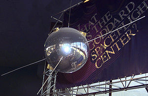 |
State & Sterling Streets, Newtown 40.22403°N 74.93602°W |
City | Business & Industry, Environment, Invention | |
| Fries Rebellion of 1799, The | Main & Broad Sts., Quakertown 40.40237°N 75.35245°W |
City | Agriculture, Ethnic & Immigration, Government & Politics, Government & Politics 18th Century, Military | ||
| Gallows Hill Gallows Hill Gallows Hill is the name given to places which were formerly the site of gallows. Such places include:* Gallows Hill SSSI, Wiltshire, a Site of Special Scientific Interest in Wiltshire... - PLAQUE |
Intersection PA 412 & SR 4075 (Gallows Hill Rd.), Stony Point 40.53117°N 75.22283°W |
Plaque | Native American, Paths & Trails | ||
| Henry Chapman Mercer Henry Chapman Mercer Henry Chapman Mercer was an American archeologist, artifact collector, tile-maker and designer of three distinctive poured concrete structures: Fonthill, his home, the Moravian Pottery and Tile Works, and the Mercer Museum.-Early life and education:Henry Mercer was born in Doylestown,... |
Pa. 313 in front of Tile Works, Doylestown 40.32378°N 75.12208°W |
Roadside | Artists, Buildings, Business & Industry, Invention, Professions & Vocations | ||
| Historic Fallsington Fallsington Historic District The Fallsington Historic District is a historic district in Fallsington, Pennsylvania.The district has a history of over 300 years. While William Penn resided at nearby Pennsbury Manor, he attended church services in Fallsington.... |
SR 2020 (Tyburn Rd.) at SR 2026 (New Falls Road), Fallingston (Missing) °N °W |
Roadside | Buildings, Cities & Towns, Early Settlement, Government & Politics, Government & Politics 17th Century, Religion, William Penn | ||
| Historic Fallsington Fallsington Historic District The Fallsington Historic District is a historic district in Fallsington, Pennsylvania.The district has a history of over 300 years. While William Penn resided at nearby Pennsbury Manor, he attended church services in Fallsington.... |
U.S. 1 at intersection LR 09136, south side of highway (Missing) °N °W |
Roadside | Early Settlement, Government & Politics, Government & Politics 17th Century, Religion, William Penn | ||
| Historic Fallsington Fallsington Historic District The Fallsington Historic District is a historic district in Fallsington, Pennsylvania.The district has a history of over 300 years. While William Penn resided at nearby Pennsbury Manor, he attended church services in Fallsington.... |
Business US 1 at SR 2020 (Tyburn Rd.) °N °W |
Roadside | Early Settlement, Government & Politics, Government & Politics 17th Century, Religion, William Penn | ||
| Honey Hollow Watershed Honey Hollow Watershed Honey Hollow Watershed is a watershed on the south side of the Delaware River a few miles north of New Hope, Pennsylvania.The Honey Hollow Watershed Conservation Area was created in 1939 and was the first agricultural area in a small watershed to show the benefits of soil, water, and wildlife... |
Rte. 232, Solebury Twp. °N °W |
Roadside | Agriculture, Environment | ||
| James A. Michener James A. Michener James Albert Michener was an American author of more than 40 titles, the majority of which were sweeping sagas, covering the lives of many generations in particular geographic locales and incorporating historical facts into the stories... |
East Court St. near Broad St., Doylestown 40.31242°N 75.12893°W |
Roadside | Writers | ||
| John Fitch John Fitch (inventor) John Fitch was an American inventor, clockmaker, and silversmith who, in 1787, built the first recorded steam-powered boat in the United States... 's Steamboat |
Jct. Pa. 132 & 263, Warminster 40.2068°N 75.0995°W |
Roadside | Business & Industry, Invention, Professions & Vocations, Transportation | ||
| Johnsville Naval Air Development Center | 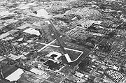 |
E Street Rd., 200 yds. N of Newton Rd., Warminster 40.19295°N 75.07532°W |
Roadside | Business & Industry, Military, Military Post-Civil War | |
| Joseph Ridgway Grundy (1863-1961) | 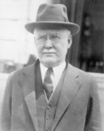 |
610-680 Radcliffe St., Bristol 40.0977°N 74.8504°W |
Roadside | Business & Industry, Government & Politics 20th Century, Publishing | |
| Katharine Drexel Katharine Drexel Saint Katharine Drexel, S.B.S., was an American Religious Sister, heiress, philanthropist and educator, later canonized as a Roman Catholic saint.-Life and religious work:... (1858-1955) |
1663 Bristol Pike, Bensalem 40.0731°N 74.9577°W |
Roadside | African American, Education, Native American, Religion, Women | ||
| Langhorne Speedway Langhorne Speedway Langhorne Speedway was an automobile racetrack in Middletown Township, Bucks County, near the borough of Langhorne, Pennsylvania, a northern suburb of Philadelphia.... |
1939 E Lincoln Hwy., Langhorne 40.17597°N 74.8858°W |
Roadside | Sports | ||
| Levittown Levittown, Pennsylvania Levittown is a census-designated place and planned community in Bucks County, Pennsylvania, United States, within the Philadelphia metropolitan area. The population was 52,983 at the 2010 census. It is above sea level... |
 |
Levittown Parkway at U.S. 13, Levittown 40.1414°N 74.8183°W |
Roadside | Buildings, Business & Industry, Cities & Towns | |
| Log College Log College The Log College was the first American Presbyterian theological seminary located in what is now Warminster, Pennsylvania. It was founded by William Tennent and his son Gilbert Tennent and operated from 1726 until William Tennent's death in 1746.... |
Between 800 and 886 N York Rd. (PA 263), near Tennyson Dr., across from Log College Manor, Warminster 40.21481°N 75.09941°W |
Roadside | Early Settlement, Education, Religion | ||
| Loyalist Raid of 1778 | State & Mercer Streets, Newtown 40.22737°N 74.93688°W |
City | American Revolution, Military, Inns & Taverns | ||
| Margaret Mead Margaret Mead Margaret Mead was an American cultural anthropologist, who was frequently a featured writer and speaker in the mass media throughout the 1960s and 1970s.... |
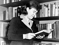 |
225 W. Court St., Doylestown 40.30682°N 75.13513°W |
City | Medicine & Science, Women, Writers | |
| Martin Johnson Heade Martin Johnson Heade Martin Johnson Heade was a prolific American painter known for his salt marsh landscapes, seascapes, portraits of tropical birds, and still lifes... (1819-1904) |
Rte. 32, Lumberville, in front of Lumberville General store 40.40653°N 75.03715°W |
City | Artists | ||
| Moland House Moland House Moland House is an old stone farmhouse built around 1750, by John Moland , a prominent Philadelphia and Bucks County lawyer. Although physically located in Hartsville, Warwick Township, Bucks County, Pennsylvania, its mailing address is in Warminster Township, Pennsylvania... |
1641 Old York Rd., Hartsville 40.2486°N 75.0927°W |
Roadside | American Revolution, George Washington, Military | ||
| Mollie Woods Hare (1881-1956) | At entrance to Woods Services, between 321 and 335 S Bellevue Ave., Langhorne 40.1731°N 74.9188°W |
Roadside | Education, Medicine & Science, Women | ||
| Oscar Hammerstein II Oscar Hammerstein II Oscar Greeley Clendenning Hammerstein II was an American librettist, theatrical producer, and theatre director of musicals for almost forty years. Hammerstein won eight Tony Awards and was twice awarded an Academy Award for "Best Original Song". Many of his songs are standard repertoire for... |
E State St. (Bus. 202) at East Rd., Doylestown 40.31273°N 75.11408°W |
Roadside | Music & Theater | ||
| Pearl S. Buck Pearl S. Buck Pearl Sydenstricker Buck also known by her Chinese name Sai Zhenzhu , was an American writer who spent most of her time until 1934 in China. Her novel The Good Earth was the best-selling fiction book in the U.S. in 1931 and 1932, and won the Pulitzer Prize in 1932... |
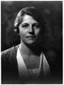 |
Green Hills Farm, 520 Dublin Road, Perkasie °N °W |
Roadside | Women, Writers | |
| Pennsbury Pennsbury Pennsbury may refer to:*Pennsbury Manor, the home of Pennsylvania founder William Penn**Pennsbury High School, a school near Pennsbury Manor that is a namesake of it*Pennsbury Village, Pennsylvania*Pennsbury Township, Pennsylvania... |
At site, E of Tullytown °N °W |
Roadside | Government & Politics, Government & Politics 17th Century, William Penn | ||
| Pennsbury Manor Pennsbury Manor Pennsbury Manor, an estate in Falls Township, Bucks County, Pennsylvania, was the American home of William Penn, founder and first Governor of Pennsylvania. The property was placed on the National Register of Historic Places on October 28, 1969.-History:... |
SR 2020 (Tyburn Rd.) S of Fallsington; SR 2059 (New Ford Rd.) at SR 2020 °N °W |
Roadside | Government & Politics, Government & Politics 17th Century, William Penn | ||
| Pennsbury Manor Pennsbury Manor Pennsbury Manor, an estate in Falls Township, Bucks County, Pennsylvania, was the American home of William Penn, founder and first Governor of Pennsylvania. The property was placed on the National Register of Historic Places on October 28, 1969.-History:... |
SR 2055 (old U.S. 13) Tullytown, near junction SR 2059 40.1427°N 74.8112°W |
Roadside | Government & Politics, Government & Politics 17th Century, William Penn | ||
| Pennsylvania Pennsylvania The Commonwealth of Pennsylvania is a U.S. state that is located in the Northeastern and Mid-Atlantic regions of the United States. The state borders Delaware and Maryland to the south, West Virginia to the southwest, Ohio to the west, New York and Ontario, Canada, to the north, and New Jersey to... |
PA 413, .4 miles west of bridge at state line, Bristol 40.08501°N 74.87121°W |
Roadside | Government & Politics, Government & Politics 17th Century, William Penn | ||
| Pennsylvania Pennsylvania The Commonwealth of Pennsylvania is a U.S. state that is located in the Northeastern and Mid-Atlantic regions of the United States. The state borders Delaware and Maryland to the south, West Virginia to the southwest, Ohio to the west, New York and Ontario, Canada, to the north, and New Jersey to... |
U.S. 1, approx. 300 yards west of Delaware River Bridge (MISSING) °N °W |
Roadside | Government & Politics, Government & Politics 17th Century, William Penn | ||
| Pennsylvania Pennsylvania The Commonwealth of Pennsylvania is a U.S. state that is located in the Northeastern and Mid-Atlantic regions of the United States. The state borders Delaware and Maryland to the south, West Virginia to the southwest, Ohio to the west, New York and Ontario, Canada, to the north, and New Jersey to... |
Bridge St. (Old US 1 / Rt. 32), at Central Ave., 1 block from Delaware River, Morrisville 40.2101°N 74.77171°W |
Roadside | Government & Politics, Government & Politics 17th Century, William Penn | ||
| Pennsylvania Canal Pennsylvania Canal Pennsylvania Canal refers generally to a complex system of canals, dams, locks, tow paths, aqueducts, and other infrastructure including, in some cases, railroads in Pennsylvania... |
Pa. 32, 3.5 miles N of New Hope °N °W |
Roadside | Canals, Navigation, Transportation | ||
| Pennsylvania Canal Pennsylvania Canal Pennsylvania Canal refers generally to a complex system of canals, dams, locks, tow paths, aqueducts, and other infrastructure including, in some cases, railroads in Pennsylvania... |
Pa. 611 at Durham Furnace (MISSING) °N °W |
Roadside | Canals, Navigation, Transportation | ||
| Pennsylvania Canal Pennsylvania Canal Pennsylvania Canal refers generally to a complex system of canals, dams, locks, tow paths, aqueducts, and other infrastructure including, in some cases, railroads in Pennsylvania... |
River Rd. (PA 32) at Old Carversville Rd., Lumberville 40.4073°N 75.03867°W |
Roadside | Canals, Navigation, Transportation | ||
| Pennsylvania Canal Pennsylvania Canal Pennsylvania Canal refers generally to a complex system of canals, dams, locks, tow paths, aqueducts, and other infrastructure including, in some cases, railroads in Pennsylvania... |
Pa. 532 W of Washington Crossing (MISSING) °N °W |
Roadside | Canals, Navigation, Transportation | ||
| Playwicky Indian Town, 1682 - PLAQUE | PA 213 (Bridgetown Pike), .5 mile from Neshaminy Creek & 2.5 miles W of Langhorne °N °W |
Plaque | Early Settlement, Government & Politics 17th Century, Native American, William Penn | ||
| Revolutionary War Burial Site | Intersection of Bellevue & Flowers Ave., Langhorne Borough 40.1739°N 74.91922°W |
Roadside | American Revolution, George Washington, Military | ||
| Richboro Nike Missile Battery PH-07 | Northampton Twp. Rec. Ctr., Rt. 332, Richboro °N °W |
Roadside | Government & Politics 20th Century, Military, Military Post-Civil War | ||
| Rochambeau Route Jean-Baptiste Donatien de Vimeur, comte de Rochambeau Marshal of France Jean-Baptiste Donatien de Vimeur, comte de Rochambeau was a French nobleman and general who participated in the American Revolutionary War as the commander-in-chief of the French Expeditionary Force which came to help the American Continental Army... |
Bristol Pike (Rt. 13) & Mill Rd., Bensalem 40.0651°N 74.9805°W |
Roadside | American Revolution, George Washington, Military, Transportation | ||
| Samuel D. Ingham Samuel D. Ingham Samuel Delucenna Ingham was a U.S. Congressman and U.S. Treasury Secretary under President Andrew Jackson.-Early life and education:... |
 |
U.S. 202, 1.5 miles W of New Hope °N °W |
Roadside | Business & Industry, Canals, Coal, Government & Politics, Government & Politics 18th Century, Professions & Vocations | |
| Summerseat Summerseat (Morrisville, Pennsylvania) Summerseat, also known as George Clymer House, Thomas Barclay House, or Summerseat School is a site significant for its association with George Clymer and Robert Morris, both signers of the Declaration of Independence and the U.S. Constitution... |
,_morrisville_(bucks_county,_pennsylvania).jpg) |
At site, Legion Ave., near Hillcrest Ave., Morrisville °N °W |
Roadside | American Revolution, George Washington, Military | |
| Treasure Island Reservation |  |
Pa. 32, 3.5 miles N of Point Pleasant 40.47102°N 75.06973°W |
Roadside | Education, Native American, Sports | |
| Trevose Trevose, Pennsylvania Trevose is a neighborhood of Bensalem and Lower Southampton in Pennsylvania, which is north of and borders northeastern Philadelphia. It shares a zip code with Feasterville-Trevose. It is not a municipality. U.S. 1 runs through the town as well as the Pennsylvania Turnpike, but Trevose's main road... |
U.S. 1, 3.5 miles W of S. Langhorne (Missing) °N °W |
City | Government & Politics, Government & Politics 17th Century, William Penn | ||
| W. Atlee Burpee W. Atlee Burpee Washington Atlee Burpee was the founder of the W. Atlee Burpee & Company, now more commonly known as Burpee Seeds... |
 |
Burpee Park, Church St. near E Oakland Ave. (Rt. 202), Doylestown 40.31088°N 75.12505°W |
City | Agriculture, Business & Industry, Entrepreneurs, Invention | |
| W.W.H. Davis | 60 E. Court Street, Doylestown 40.31207°N 75.12928°W |
City | Civil War, Government & Politics, Government & Politics 19th Century, Military, Professions & Vocations, Writers | ||
| Walking Purchase Walking Purchase The Walking Purchase was a purported 1737 agreement between the Penn family, the proprietors of Pennsylvania, and the Lenape . By it the Penn family and proprietors claimed an area of 1,200,000 acres and forced the Lenape to vacate it... |
PA 412 off PA 212, near Moyer Rd., ~1.5 mi. SW of Springtown 40.54597°N 75.30358°W |
Roadside | Early Settlement, Government & Politics 18th Century, Native American, William Penn | ||
| Walking Purchase Walking Purchase The Walking Purchase was a purported 1737 agreement between the Penn family, the proprietors of Pennsylvania, and the Lenape . By it the Penn family and proprietors claimed an area of 1,200,000 acres and forced the Lenape to vacate it... |
U.S. 611 at Ottsville °N °W |
Roadside | Early Settlement, Government & Politics 18th Century, Native American, William Penn | ||
| Walking Purchase Walking Purchase The Walking Purchase was a purported 1737 agreement between the Penn family, the proprietors of Pennsylvania, and the Lenape . By it the Penn family and proprietors claimed an area of 1,200,000 acres and forced the Lenape to vacate it... |
Pa. 413 at Penn Park Rd., near Wrightstown (in yard of Friends Mtg. House beside 10' tall brown stone) °N °W |
Roadside | Government & Politics, Government & Politics 17th Century, Native American | ||
| Walking Purchase Walking Purchase The Walking Purchase was a purported 1737 agreement between the Penn family, the proprietors of Pennsylvania, and the Lenape . By it the Penn family and proprietors claimed an area of 1,200,000 acres and forced the Lenape to vacate it... |
PA 413 at Wrightstown (Missing) °N °W |
Roadside | Government & Politics, Government & Politics 18th Century, Native American | ||
| Walking Purchase Walking Purchase The Walking Purchase was a purported 1737 agreement between the Penn family, the proprietors of Pennsylvania, and the Lenape . By it the Penn family and proprietors claimed an area of 1,200,000 acres and forced the Lenape to vacate it... |
Pa. 611, .5 mile N of Ottsville (Missing) °N °W |
Roadside | Government & Politics, Government & Politics 18th Century, Native American | ||
| Walking Purchase Walking Purchase The Walking Purchase was a purported 1737 agreement between the Penn family, the proprietors of Pennsylvania, and the Lenape . By it the Penn family and proprietors claimed an area of 1,200,000 acres and forced the Lenape to vacate it... |
PA 412, SW of Springtown °N °W |
Roadside | Government & Politics 18th Century, Native American, William Penn | ||
| Washington Crossing Washington Crossing Washington Crossing may refer to:Places:* Washington's Crossing, the location in both New Jersey and Pennsylvania, a U.S. National Historic Landmark* Washington Crossing State Park, Titusville, New Jersey* Washington Crossing, Pennsylvania... |
Pa. 532 at Washington Crossing °N °W |
Roadside | American Revolution, George Washington, Military | ||
| William Penn William Penn William Penn was an English real estate entrepreneur, philosopher, and founder of the Province of Pennsylvania, the English North American colony and the future Commonwealth of Pennsylvania. He was an early champion of democracy and religious freedom, notable for his good relations and successful... 's First Walking Purchase Walking Purchase The Walking Purchase was a purported 1737 agreement between the Penn family, the proprietors of Pennsylvania, and the Lenape . By it the Penn family and proprietors claimed an area of 1,200,000 acres and forced the Lenape to vacate it... |
Jericho Creek @ intersection of River & Taylorsville Rds., Washington Crossing °N °W |
Roadside | Early Settlement, Government & Politics, Native American, Paths & Trails, Transportation, William Penn |
See also
- List of Pennsylvania state historical markers
- National Register of Historic Places listings in Bucks County, Pennsylvania