
List of Marilyns in Ireland
Encyclopedia
This is a list of the 389 Marilyns
in the Republic of Ireland
. It was originally published in The Hewitts and Marilyns of Ireland by Clem Clements, and is one of several lists of hills
that include Ireland.
Marilyn (hill)
A Marilyn is a mountain or hill in the United Kingdom, Republic of Ireland or Isle of Man with a relative height of at least 150 metres , regardless of absolute height or other merit...
in the Republic of Ireland
Republic of Ireland
Ireland , described as the Republic of Ireland , is a sovereign state in Europe occupying approximately five-sixths of the island of the same name. Its capital is Dublin. Ireland, which had a population of 4.58 million in 2011, is a constitutional republic governed as a parliamentary democracy,...
. It was originally published in The Hewitts and Marilyns of Ireland by Clem Clements, and is one of several lists of hills
Hill lists in the British Isles
The mountains and hills of Great Britain, and to a lesser extent Ireland, are the subject of a considerable number of lists that categorise them by height, topographic prominence, or other criteria. They are commonly used as a basis for peak bagging, whereby hillwalkers attempt to reach all the...
that include Ireland.
45A
| Peak | Height (m) | Prom. (m) | Grid ref. | |
|---|---|---|---|---|
| Slieve Snaght Slieve Snaght Slieve Snaght is a mountain in Inishowen, County Donegal, Ireland, not to be confused with the mountain of the same name in the nearby Derryveagh range.- References :* *... (Sliabh Sneachta) |
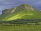
615 | 600 | 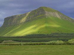 Benbulbin |
|
| Raghtin More (Reachtain Mhór) | 502 | 404 | ||
| Benbulbin (Binn Ghulbain) | 494 | 300 | ||
| Scalp Mountain | 484 | 298 | ||
| Urris Urris Urris is an area in the west of the parish of Clonmany, in County Donegal, Ireland. The area hosts the Urris Gaelic Athletic Association team for Gaelic football, which has a pitch located just outside Urris, in the Townland of Straid.-History:... (Cnoic Iorrais) |
417 | 170 | ||
| Grinlieve | 371 | 216 | ||
| Crocknasmug (Cnoc na Smug) | 328 | 214 | ||
| Mouldy Hill | 312 | 168 | ||
| Coolcross Hill | 291 | 168 | ||
| Mongorry Hill | 284 | 176 | ||
| Crockalough | 282 | 269 | ||
| Dooish Mountain (An Dubhais) | 266 | 172 | ||
| Binnion | 250 | 194 | ||
| Dunaff Hill | 232 | 210 | ||
| Inch Top (An Inis) | 222 | 222 | ||
| Croaghan Hill | 217 | 172 | ||
Derryveagh, Glendowan
| Peak | Height (m) | Prom. (m) | Grid ref. | |
|---|---|---|---|---|
| Errigal Mountain Mount Errigal Mount Errigal, or simply Errigal is a mountain near Gweedore in County Donegal, Republic of Ireland. It is the tallest peak of the Derryveagh Mountains, the tallest peak in County Donegal, and the 76th tallest peak in Ireland. Errigal is also the most southern, steepest and highest of the... (An Earagail) |
749 | 688 | 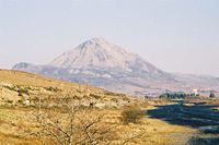 Errigal Mountain Mount Errigal Mount Errigal, or simply Errigal is a mountain near Gweedore in County Donegal, Republic of Ireland. It is the tallest peak of the Derryveagh Mountains, the tallest peak in County Donegal, and the 76th tallest peak in Ireland. Errigal is also the most southern, steepest and highest of the... |
|
| Slieve Snaght Slieve Snaght Slieve Snaght is a mountain in Inishowen, County Donegal, Ireland, not to be confused with the mountain of the same name in the nearby Derryveagh range.- References :* *... (Sliabh Sneachta) |
678 | 400 | ||
| Muckish Mountain Muckish Muckish is a distinctive flat-topped mountain in the Derryveagh Mountains of County Donegal, Republic of Ireland. At , it is the third-highest peak in the Derryveagh Mountains and the 163rd highest in Ireland. Muckish is also the most northern and second highest of the mountain chain called the... (Mucais) |
666 | 480 | ||
| Dooish Dooish Dooish is a village and townland near Drumquin in County Tyrone, Northern Ireland. In the 2001 Census it had a population of 93 people. It lies within the Omagh District Council area.-References:*... (Dubhais) |
652 | 320 | ||
| Aghla Beg Aghla Beg Aghla Beg is a mountain in County Donegal, Ireland. Of its two summits, one has a height of 564 m, and the other 603 m. It is the third most northern and fifth highest of the mountain chain, called the Seven Sisters by locals Muckish, Crocknalaragagh, Aghla Beg, Ardloughnabrackbaddy,... (Eachla Beag) |
603 | 366 | ||
| Mackoght Mackoght Mackoght or Macoght , also called Little Errigal or Wee Errigal , is a tall mountain in County Donegal, Republic of Ireland. It is the second most southern and second lowest of the mountain chain called the Seven Sisters by locals. The Seven Sisters are Muckish, Crocknalaragagh, Aghla Beg,... (Maigh Ocht) |
555 | 150 | ||
| Moylenanav | 539 | 296 | ||
| Crocknafarragh | 517 | 172 | ||
| Crocknalaragagh Crocknalaragagh Crocknalaragagh is a mountain in County Donegal, Ireland with a height of 470 m. It is the second most northern and lowest of the mountain chain, locally called the Seven Sisters that also includes Muckish, Aghla Beg, Ardloughnabrackbaddy, Aghla More, Mackoght and Errigal. All of the Seven... (Cnoc na Láragacha) |
471 | 182 | ||
| Loughsalt Mountain | 469 | 360 | ||
| Leahanmore | 442 | 254 | ||
| Tievealehid | 429 | 304 | ||
| Farscallop | 423 | 180 | ||
| Meentycat | 369 | 194 |  Muckish Mountain Muckish Muckish is a distinctive flat-topped mountain in the Derryveagh Mountains of County Donegal, Republic of Ireland. At , it is the third-highest peak in the Derryveagh Mountains and the 163rd highest in Ireland. Muckish is also the most northern and second highest of the mountain chain called the... |
|
| Knockalla Mountain | 363 | 325 | ||
| Whitehill Whitehill Whitehill is a family surname, appearing both in literature and in historical references.-Whitehills in literature:As fictional family, the Whitehills are featured in the short stories of Brazilian writer Rita Maria Felix da Silva.... |
357 | 208 | ||
| Lurganboy | 357 | 184 | ||
| Crockmore | 349 | 173 | ||
| Gregory Hill | 336 | 254 | ||
| Crovehy | 315 | 162 | ||
| Bloody Foreland | 314 | 228 | ||
| Stragraddy Mountain | 285 | 160 | ||
| Croaghnamaddy | 252 | 247 | ||
| Cluidaniller | 227 | 227 | ||
| Murren Hill | 227 | 200 | ||
| Ganiamore | 207 | 198 | ||
| Crocknasleigh | 163 | 159 | ||
The Blue Stack Mountains
| Peak | Height (m) | Prom. (m) | Grid ref. | |
|---|---|---|---|---|
| Croaghgorm Croaghgorm Croaghgorm or Bluestack is a 674 m mountain in County Donegal, Ireland. It is the highest of the Bluestack Mountains and the third-highest mountain in County Donegal.... |
674 | 522 | 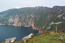 Slieve League Slieve League Slieve League, sometimes Slieve Leag or Slieve Liag , is a mountain on the Atlantic coast of County Donegal, Republic of Ireland. At , it has Ireland's highest sea cliffs... |
|
| Lavagh More | 671 | 193 | ||
| Silver Hill Silver Hill Silver Hill is a very small settlement in the Demerara-Mahaica Region of Guyana, up the Soesdyke-Linden Highway, which runs along the east bank of the Demerara River.... |
600 | 151 | ||
| Slieve League Slieve League Slieve League, sometimes Slieve Leag or Slieve Liag , is a mountain on the Atlantic coast of County Donegal, Republic of Ireland. At , it has Ireland's highest sea cliffs... |
595 | 472 | ||
| Aghla Mountain | 593 | 390 | ||
| Croaghnageer | 571 | 266 | ||
| Gaugin Mountain | 565 | 294 | ||
| Croaghconnellagh | 523 | 270 | ||
| Carnaween | 521 | 166 | ||
| Meenacurrin | 511 | 376 | ||
| Common Mountain | 501 | 320 | ||
| Crownarad | 493 | 210 | ||
| Croveenananta | 476 | 222 | ||
| Barnesmore | 451 | 270 | ||
| Boultypatrick | 429 | 170 | ||
| Scraigs | 428 | 234 | ||
| Leahan | 427 | 204 | ||
| Croaghleheen | 385 | 228 | ||
| Croaghacullion | 374 | 220 | ||
| Altnapaste | 364 | 162 | ||
| Crockkinnagoe | 353 | 202 | ||
| Mulmosog Mountain | 351 | 208 | ||
| Derkbeg Hill | 332 | 178 | ||
| Croaghleconnell | 266 | 191 | ||
| Croaghegly | 245 | 213 | ||
45D
| Peak | Height (m) | Prom. (m) | |
|---|---|---|---|
| Cuilcagh Cuilcagh Cuilcagh, historically Slieve Cuilcagh , is the highest mountain in the Breifne area and the 165th highest on the island of Ireland . The summit lies on the border between County Fermanagh and County Cavan , and is the highest point in both counties... |
665 | 606 | |
| Truskmore Truskmore Truskmore is a 647 m mountain on the border of County Sligo and County Leitrim, Republic of Ireland. It is the highest peak of the Dartry Mountains and the highest in County Sligo.... |
647 | 560 | |
| Slievemore Slievemore Slievemore is the second highest peak on Achill Island, in County Mayo, Ireland. Its elevation is 671 metres.-Archaeology:* Achill Archaeological Field School is based at the Achill Archaeology Centre in Dooagh. It was founded in 1991 and is a training school for students of archaeology and... |
597 | 214 | |
| Slieve Anierin | 585 | 250 | |
| The Playbank | 542 | 185 | |
| Arroo | 523 | 436 | |
| Dough Mountain | 465 | 268 | |
| Crockauns | 463 | 386 | |
| Carran Hill | 458 | 395 | |
| Lackagh Lackagh The parish of Lackagh or Lacagh is located in County Galway in the West of Ireland, approximately half way between Galway city and Tuam . It is bounded by the parishes of Athenry, Abbeyknockmoy, Corofin, Annaghdown and Claregalway... |
447 | 340 | |
| Thur Mountain | 442 | 228 | |
| Benbo | 415 | 214 | |
| Slieve Rushen Slieve Rushen Slieve Rushen is a mountain which straddles the border between County Cavan in the Republic of Ireland and County Fermanagh in Northern Ireland. It is also called Slieve Russell or Ligavegra . It has an altitude of 404 metres above sea-level. OS 1/50k Mapsheet: 27A & 26... |
403 | 332 | |
| Killerry Mountain | 293 | 232 | |
| Corn Hill Corn Hill Corn Hill may refer to:* Corn Hill, Longford, Leinster, Ireland* Corn Hill, New Brunswick, Canada... |
276 | 225 | |
| Slieve Daeane | 275 | 217 | |
| Slieve Bawn | 261 | 215 | |
| Bruse Hill | 258 | 190 | |
45E
| Peak | Height (m) | Prom. (m) | Grid ref. | |
|---|---|---|---|---|
| Knockalongy Knockalongy Knockalongy is a 544 m Marilyn in County Sligo, Republic of Ireland. It is the highest of the Ox Mountains. The nearest village is Skreen.... |
544 | 482 | Knocknarea Knocknarea Knocknarea is a large hill west of Sligo town in County Sligo, Republic of Ireland.The high limestone hill is visually striking, as it is monolithic in appearance and stands in a prominent position on the Cúil Irra peninsula between the bays of Sligo and Ballysadare. At the summit is a large... |
|
| Knockasliggaun | 417 | 242 | ||
| Largan Hill | 413 | 228 | ||
| Kesh Corann | 359 | 280 | ||
| Knocknarea Knocknarea Knocknarea is a large hill west of Sligo town in County Sligo, Republic of Ireland.The high limestone hill is visually striking, as it is monolithic in appearance and stands in a prominent position on the Cúil Irra peninsula between the bays of Sligo and Ballysadare. At the summit is a large... |
327 | 306 | ||
| Bricklieve Mountains | 321 | 173 | ||
| Knocknashee Common | 276 | 174 | ||
| Cuillalea | 262 | 200 | ||
| Curlew Mountain | 261 | 150 | ||
| Mullaghanoe | 234 | 150 | ||
| Carranarah | 197 | 152 | ||
46A
| Peak | Height (m) | Prom. (m) | Grid ref. |
|---|---|---|---|
| Maumakeogh | 379 | 294 | |
| Tawnaghmore | 340 | 284 | |
| Slieve Fyagh | 335 | 198 | |
| Glinsk Glinsk Glinsk is a small village in County Galway, in the west of Ireland, between Creggs and Ballymoe. Glinsk is located approximately 68 km from Galway city and approximately 30 km from Roscommon. It is located in valley of the River Suck, which has a 60 mile hiking trail. Nearby is the... |
304 | 178 | |
| Carrafull | 269 | 160 | |
| Barnacuille | 264 | 240 | |
| Benwee Head Benwee Head Benwee Head Cliffs County MayoGaelic: An Bhinn BhuíHeight: 304 metres OS 1/50k Mapsheet: 22 for topGrid Ref: F816 443 Latitude: 54.333659 Longitude: -9.820924ITM: 481576 844301 Prominence: 230m Isolation: 5.4 km... |
255 | 233 | |
| Carrowmore Hill | 244 | 232 | |
| Ballycastle Hill | 237 | 192 | |
| Barradeegin | 229 | 194 | |
Nephin Beg range
| Peak | Height (m) | Prom. (m) | Grid ref. |
|---|---|---|---|
| Nephin Nephin Nephin or Nefin , at 806 metres , is the second highest peak in County Mayo and the second highest in Connacht, in Ireland... |
806 | 750 | |
| Slieve Cor | 721 | 648 | |
| Corranabinnia | 716 | 540 | |
| Birreencorragh | 698 | 582 | |
| Nephin Beg Nephin Beg Nephin Beg or Nefin Beg is a mountain in the Nephin Beg Range in north County Mayo, Ireland. The mountain takes its name from Nephin, although that mountain is some distance away and with intervening mountains between them The highest point is 365 meters.... |
627 | 364 | |
| Buckoogh | 588 | 425 | |
| Bengorm | 582 | 225 | |
| Corraun Hill | 541 | 504 | |
| Owenduff Hill | 452 | 305 | |
| Croaghmoyle | 430 | 378 | |
| Farbreiga | 395 | 238 | |
| Bullaunmore | 388 | 174 | |
| Knocklettercuss | 370 | 212 | |
| Slieve Alp | 329 | 192 | |
| Tristia | 322 | 210 | |
| Lettertrask | 279 | 150 | |
| Bunmore West | 243 | 204 | |
46C
| Peak | Height (m) | Prom. (m) | Grid ref. |
|---|---|---|---|
| Croaghaun Croaghaun Croaghaun is a mountain in County Mayo, Ireland. At 688 metres , it has the highest cliffs in Ireland and the second highest sea cliffs in Europe .... |
688 | 688 | |
| Slievemore Slievemore Slievemore is the second highest peak on Achill Island, in County Mayo, Ireland. Its elevation is 671 metres.-Archaeology:* Achill Archaeological Field School is based at the Achill Archaeology Centre in Dooagh. It was founded in 1991 and is a training school for students of archaeology and... |
671 | 582 | |
| Menawn | 466 | 420 | |
| Knockmore Knockmore Knockmore is an upland area and townland situated in County Fermanagh, Northern Ireland. It is situated outside the village of Derrygonnelly, in the historical barony of Magheraboy. This area, together with most of the adjacent Boho parish is described as the Knockmore Scarplands... |
337 | 259 | |
| Derreen | 286 | 250 | |
| Doogort Hill | 214 | 160 | |
47A
| Peak | Height (m) | Prom. (m) | Grid ref. | |
|---|---|---|---|---|
| Mweelrea Mweelrea Mweelrea is a mountain in County Mayo, Republic of Ireland. With a height of 814 metres , it is the highest point in County Mayo, the highest point in the province of Connacht and the 34th highest in Ireland... |
814 | 778 |  Mweelrea Mweelrea Mweelrea is a mountain in County Mayo, Republic of Ireland. With a height of 814 metres , it is the highest point in County Mayo, the highest point in the province of Connacht and the 34th highest in Ireland... |
|
| Ben Lugmore | 803 | 158 | ||
| Barrclashcame Barrclashcame Barrclashcame is a 772 m mountain in County Mayo, Republic of Ireland. It is within the townland of Clashcame and is the highest peak of the Sheeffry Hills.... |
772 | 706 | ||
| Croagh Patrick Croagh Patrick Croagh Patrick , nicknamed the Reek, is a tall mountain and an important site of pilgrimage in County Mayo, Republic of Ireland. It is from Westport, above the villages of Murrisk and Lecanvey. It is the third highest mountain in County Mayo after Mweelrea and Nephin. On "Reek Sunday", the last... |
764 | 640 | ||
| Ben Gorm Ben Gorm - References :*... |
700 | 612 | ||
| Garraun | 598 | 535 | ||
| Doughruagh | 526 | 210 | ||
| Knockmore Knockmore Knockmore is an upland area and townland situated in County Fermanagh, Northern Ireland. It is situated outside the village of Derrygonnelly, in the historical barony of Magheraboy. This area, together with most of the adjacent Boho parish is described as the Knockmore Scarplands... |
462 | 462 | ||
| Tangincartoor | 390 | 204 | ||
| Tonatleva | 379 | 212 | ||
| Tully Mountain Tully Mountain Tully Mountain, , is a prominent, steep-sided monadnock located in north central Massachusetts in the town of Orange, approximately five miles south of the New Hampshire border. An exposed south and west facing ledge on the summit provides views of the Millers River valley, Mount Monadnock, Mount... |
356 | 320 | ||
| Binn Mhor | 333 | 264 | ||
| Mountain Common | 191 | 191 | ||
| Maumfin | 172 | 150 | ||
The Twelve Bens
| Peak | Height (m) | Prom. (m) | Grid ref. |
|---|---|---|---|
| Benbaun Benbaun Benbaun is a mountain in County Galway, Ireland, the highest of the Twelve Bens, and the highest peak in Galway. As the highest point in Galway, it is the 10th highest county peak in Ireland.... |
729 | 686 | |
| Bencorr Bencorr Bencorr is a mountain in Galway, Ireland. With a height of 711 metres it is the second highest mountain in the Twelve Bens after Benbaun and the 101st highest summit in Ireland. It is the second highest mountain in Galway. Englishman Tim Robinson gave this mountain the alternative name of Binn an... |
711 | 304 | |
| Bencollaghduff | 696 | 200 | |
| Benbreen | 691 | 235 | |
| Bengower | 664 | 198 | |
| Muckanaght | 654 | 182 | |
| Bencullagh | 632 | 155 | |
| Benbrack | 582 | 264 | |
| Diamond Hill | 442 | 278 | |
| Cashel Hill | 311 | 264 | |
| Errisbeg Errisbeg Errisbeg Mountain or Errisbeg situated at Roundstone, County Connemara, in the West of Ireland with a height of 300 m.... |
300 | 274 | |
Maumturk Mountains
| Peak | Height (m) | Prom. (m) | Grid ref. |
|---|---|---|---|
| Barrslievenaroy Barrslievenaroy Barrslievenaroy —also called Binn idir an Dá Log— is a 702 m mountain in County Galway, Republic of Ireland. It is the highest of the Maumturks range, which lie within the Connemara region.... |
702 | 629 | |
| Maumtrasna Maumtrasna Maumtrasna is a mountain in County Mayo, Ireland.The name derives from its Irish name which is roughly translated as the "Mountain pass crossing".- References :*... |
682 | 608 | |
| Letterbreckaun | 667 | 322 | |
| Binn Mhor | 661 | 406 | |
| Devilsmother Devilsmother Devilsmother , also known as Binn Gharbh , is a small mountain in Connemara, Ireland. It is just off the edge of the Maumturks chain and overlooks the Western Way long distance path.... |
645 | 280 | |
| Leenaun Hill | 618 | 360 | |
| Corcogemore | 609 | 226 | |
| Bunnacunneen | 575 | 463 | |
| Rinavore | 426 | 242 | |
| Bohaun | 424 | 158 | |
| Benlevy | 416 | 352 | |
| Lissoughter | 401 | 336 | |
| Lackavrea | 396 | 300 | |
| Knocknamuck Knocknamuck Knocknamuck is a mountain in South Tipperary, Ireland. Its name means Hill of the Pig. At 340 metres it is highest summit in the Slieveardagh Hills and the 916th highest summit in Ireland.-See also:* List of mountains in Ireland... |
372 | 264 | |
| Shannavara | 358 | 301 | |
| Cnoc Mordain | 354 | 320 | |
| Lackadunna | 346 | 310 | |
| Derroura | 305 | 262 | |
48A
| Peak | Height (m) | Prom. (m) | Grid ref. |
|---|---|---|---|
| Moylussa | 532 | 480 | |
| Tountinna | 457 | 406 | |
| Maghera | 400 | 325 | |
| Slievecallan | 391 | 365 | |
| Cappaghabaun Mountain | 376 | 300 | |
| Cashlaundrumlahan | 365 | 225 | |
| Slieve Elva | 344 | 280 | |
| Slievecarran | 324 | 180 | |
| Woodcock Hill Woodcock Hill Woodcock Hill is a small area of Birmingham, England, located near Bartley Green.... |
310 | 248 | |
| Knockanuarha | 309 | 274 | |
| Abbey Hill | 240 | 164 | |
48B
| Peak | Height (m) | Prom. (m) | Grid ref. |
|---|---|---|---|
| Knockanefune | 451 | 294 | |
| Knockanimpuha | 345 | 152 | |
| Knockfeerina | 288 | 180 | |
| Knockanore Mountain | 267 | 225 | |
| Maulin Mountain | 217 | 200 | |
48C
| Peak | Height (m) | Prom. (m) | Grid ref. |
|---|---|---|---|
| The Paps (East) | 694 | 402 | |
| Caherbarnagh | 681 | 364 | |
| Mullaghanish Mullaghanish Mullaghanish is a mountain located just northeast of Ballyvourney in County Cork, Ireland. It is home to one of RTÉ's main transmitters, as well as some other mobile phone and independent radio stations.... |
649 | 264 | |
| Musheramore Musheramore Musheramore is a 644 m mountain in County Cork, Ireland. It is the highest of the Boggeragh Mountains.There are two holy wells on the mountain: one at the summit for sick animals and one on its northern slopes for humans.... |
644 | 438 | |
| Mount Hillary | 391 | 175 | |
| The Burren The Burren The Burren is a karst-landscape region or alvar in northwest County Clare, in Ireland. It is one of the largest karst landscapes in Europe. The region measures approximately 250 square kilometres and is enclosed roughly within the circle made by the villages Ballyvaughan, Kinvara, Tubber, Corofin,... |
380 | 165 | |
49A
| Peak | Height (m) | Prom. (m) | Grid ref. | |
|---|---|---|---|---|
| Brandon Mountain Mount Brandon Mount Brandon or Brandon Mountain is a 952 m mountain on the Dingle Peninsula in County Kerry, Republic of Ireland. It is the highest peak of the unnamed central mountain range of the Dingle Peninsula and the ninth highest peak in Ireland... |
951 | 930 | Tearaght Island Tearaght Island Tearaght Island or Inishtearaght is an uninhabited steep rocky island west of the Dingle Peninsula, County Kerry, Republic of Ireland. At longitude 10° 39.7' Tearaght is the westernmost of the Blasket Islands, and thus the westernmost island in the Republic of Ireland and the British Isles... |
|
| Brandon Peak | 840 | 178 | ||
| Ballysitteragh | 623 | 215 | ||
| Mount Eagle | 516 | 458 | ||
| Croaghmarhin | 403 | 218 | ||
| Lateevemore | 318 | 205 | ||
| Croaghmore | 292 | 292 | ||
| Reenconnell | 274 | 158 | ||
| Ballydavid Head | 247 | 220 | ||
| Sybil Point | 206 | 198 | ||
| Tearaght Island Tearaght Island Tearaght Island or Inishtearaght is an uninhabited steep rocky island west of the Dingle Peninsula, County Kerry, Republic of Ireland. At longitude 10° 39.7' Tearaght is the westernmost of the Blasket Islands, and thus the westernmost island in the Republic of Ireland and the British Isles... |
200 | 200 | ||
| Ballymacadoyle Hill | 184 | 170 | ||
| Inishnabro Inishnabro Inishnabro is one of the Blasket Islands of County Kerry, Ireland. It is separated from Inishvickillane by a narrow sound , and rises to 175 metres.... |
175 | 175 | ||
| Inishtooskert Inishtooskert Inishtooskert is the northernmost of the Blasket Islands, County Kerry, Ireland. The name means "northern island". The island is also known as An Fear Marbh or the sleeping giant due to its appearance when seen from the east... |
172 | 172 | ||
49B
| Peak | Height (m) | Prom. (m) | |
|---|---|---|---|
| Baurtregaum Baurtregaum Baurtregaum or Bartregaum is a 851 m mountain peak in County Kerry, Republic of Ireland. It is the highest of the Slieve Mish Mountains and the 17th highest peak in Ireland.... |
851 | 642 | |
| Beenoskee Beenoskee Beenoskee or Benoskee is a 826 m mountain on the Dingle Peninsula in County Kerry, Republic of Ireland. Part of the Dingle Mountains, it is the highest of the "Central Dingle" group and the 28th highest in Ireland.... |
826 | 492 | |
| Slievanea | 670 | 273 | |
| Banoge North | 641 | 178 | |
| Moanlaur | 566 | 289 | |
| Cumminan Hill | 552 | 206 | |
| Cummeen | 477 | 160 | |
| Brickany | 374 | 230 | |
| Knocknanacree | 286 | 260 | |
50A
| Peak | Height (m) | Prom. (m) | Grid ref. |
|---|---|---|---|
| Coomacarrea | 772 | 474 | |
| Knocknadobar | 690 | 568 | |
| Foilclogh | 497 | 350 | |
| Seefin Seefin Seefin may refer to:*Seefin, a townland in County Cavan, Ireland,near to Lough Acurry between Cavan and Bailieborough.*Seefin , a mountain in County Limerick, Ireland.*Seefin , a mountain in County Waterford, Ireland.... |
493 | 168 | |
| Bolus | 410 | 388 | |
| Knocknaskereighta | 397 | 280 | |
| Bentee | 376 | 270 | |
| Castlequin Hill | 361 | 338 | |
| Derryfanga | 353 | 190 | |
| Killonecaha Hill | 331 | 214 | |
| Killelan Mountain | 278 | 225 | |
| Curra Hill | 275 | 170 | |
| Geokaun Geokaun Mountain and Fogher Cliffs Geokaun Mountain is the highest mountain on Valentia Island, County Kerry. On its northern face the Fogher Cliffs meet the sea.From the summit there are views of the Skellig Islands, Dingle Peninsula, the Blasket Islands, Beginish Island, Cahersiveen, Portmagee and Macgillycuddy's Reeks, including... |
266 | 266 | |
| Foiltagarriff | 239 | 200 | |
| South Peak | 217 | 217 | |
| Puffin Island Puffin Island, Kerry Puffin Island is an uninhabited steep rocky island lying off the coast of the Iveragh Peninsula, County Kerry, Ireland. The island is about 1.5 km long and 0.7 km wide, and rises to 159 metres. It is separated from the mainland by Puffin Sound, which is only about 250 metres across... |
159 | 159 | |
50B
| Peak | Height (m) | Prom. (m) | Grid ref. |
|---|---|---|---|
| Stumpa Duloigh | 784 | 496 | |
| Mullaghanattin | 773 | 515 | |
| Beann | 752 | 166 | |
| Broaghnabinnia | 745 | 298 | |
| Knockmoyle Knockmoyle Knockmoyle is a hamlet and townland about 8 kilometres northwest of Omagh in County Tyrone, Northern Ireland. In the 2001 census the Knockmoyle area had 141 households and a population of 329. It has a post office, church and public house. The nearby River Strule is well known for its trout fishing... |
684 | 168 | |
| Coomcallee | 675 | 290 | |
| Knocklomena | 641 | 385 | |
| Cnoc na gCapall | 639 | 332 | |
| Eagles Hill | 549 | 232 | |
| Knocknacusha | 547 | 240 | |
| Knocknagullion | 413 | 250 | |
| Knockanaskill | 356 | 152 | |
| Derry Hill Derry Hill Derry Hill is a village in the English county of Wiltshire, belonging to the civil parish of Calne Without.-Geography:Derry Hill is located to the south of the A4 road, east of Chippenham and to the west of Calne... |
308 | 180 | |
| Scarriff Island | 252 | 252 | |
Macgillycuddy's Reeks
| Peak | Height (m) | Prom. (m) | Grid ref. | |
|---|---|---|---|---|
| Carrauntoohil | 1038 | 1038 |  Carrauntoohil |
|
| Cnoc na Péiste Cnoc na Péiste Cnoc na Péiste—often anglicised as Knocknapeasta and more rarely given as Slievenapeesta or Cummeennapeasta—is a 988 m mountain peak in County Kerry, Republic of Ireland... |
988 | 252 | ||
| Purple Mountain | 832 | 594 | ||
51A
| Peak | Height (m) | Prom. (m) | Grid ref. |
|---|---|---|---|
| Hungry Hill Hungry Hill Hungry Hill is a 685 m, 2248 ft mountain on the Beara Peninsula in the Republic of Ireland. It is the highest peak of the Caha Mountains and the 130th highest in Ireland... |
685 | 400 | |
| Knockowen | 658 | 330 | |
| Coomnadiha | 644 | 208 | |
| Maulin Maulin Maulin is a hill located in the northeastern section of the Wicklow Mountains, close to the border with County Dublin. It can be found on a side trail off the main Wicklow Way. It is readily accessible via well-marked trails from Crone Wood carpark, located south-west of Enniskerry... |
621 | 225 | |
| Lackabane | 602 | 290 | |
| Knocknagorraveela | 507 | 152 | |
| Knockoura Knockoura Knockgour is a mountain in County Cork, Ireland. Approx 480 metres high and one of the Irish Hangliding & Paragliding Sites as well as being a site for 4 communications masts for telephone, TV, VHF, coastguard and WiMax antennas... |
490 | 395 | |
| Knockeirka | 426 | 184 | |
| Knockanoughanish | 386 | 192 | |
| Miskish Mountain | 386 | 182 | |
| Derrynafulla | 380 | 152 | |
| Knocknagallaun | 376 | 150 | |
| Knockatee | 330 | 176 | |
| Knockanallig | 267 | 267 | |
| Lackacroghan | 260 | 162 | |
| Tower Hill | 252 | 252 | |
| Disert | 205 | 168 | |
51B
| Peak | Height (m) | Prom. (m) | Grid ref. |
|---|---|---|---|
| Mount Gabriel Mount Gabriel Mount Gabriel is a mountain on the Mizen Peninsula situated immediately to the north of the town of Schull, in West Cork, Ireland.Mt. Gabriel is 407m high and is the highest eminence in the coastal zone south and east of Bantry Bay. A roadway serving the radar installations on the summit is open... |
407 | 310 | |
| Seefin Seefin Seefin may refer to:*Seefin, a townland in County Cavan, Ireland,near to Lough Acurry between Cavan and Bailieborough.*Seefin , a mountain in County Limerick, Ireland.*Seefin , a mountain in County Waterford, Ireland.... |
345 | 263 | |
| Knocknamaddree | 313 | 278 | |
| Derrylahard Hill | 301 | 178 | |
| Knockaphuca | 237 | 173 | |
| Mizen Peak | 232 | 178 | |
| Knockomagh | 197 | 178 | |
| Cape Clear Island | 160 | 160 | |
52A
| Peak | Height (m) | Prom. (m) | Grid ref. |
|---|---|---|---|
| Mangerton Mountain Mangerton Mountain Mangerton or Mangerton Mountain is a mountain in County Kerry, Republic of Ireland. At a height of 839 m it is the tallest of the Mangerton range and 25th tallest in Ireland... |
843 | 586 | |
| Knockboy Knockboy Knockboy is a 706-metre-high mountain on the border between counties Cork and Kerry in Ireland. It is the highest peak in the Shehy mountain range and the highest mountain in County Cork with its summit shared with County Kerry. It is the 104th highest peak in Ireland... |
706 | 610 | |
| Crohane | 656 | 388 | |
| Knocknamanagh | 637 | 180 | |
| Carran Carran Carran is a village in County Clare, Ireland, bounded on the northwest by County Galway and on the south by Kilinaboy, Slieve Carron, one of the highest points in the Burren lies just north of the village,the area is renowned for its walking trails and spectacular views over the Burren... |
604 | 238 | |
| Peakeen Mountain | 555 | 278 | |
| Torc Mountain Torc Mountain Torc Mountain is a mountain near Killarney in County Kerry, Ireland which is 535 m high. Torc Mountain gets its name from an enchanted boar that was killed there by the legendary hero, Fionn mac Cumhaill. Torc Mountain is the 383rd highest summit in Ireland.-See also:*Mountains of East Kerry... |
535 | 298 | |
| Knockanaguish | 509 | 186 | |
| Coomagearlahy | 506 | 185 | |
| Bennaunmore | 454 | 152 | |
| Cappanlivane | 406 | 246 | |
52B
| Peak | Height (m) | Prom. (m) | Grid ref. |
|---|---|---|---|
| Carrigmount | 546 | 344 | |
| Nowen Hill | 535 | 298 | |
| Mullaghmesha | 494 | 210 | |
| Douce Mountain | 476 | 214 | |
| Doughill Mountain | 471 | 198 | |
| Milane Hill | 355 | 160 | |
| Carrigfadda | 313 | 210 | |
| Maulanimirish Hill | 298 | 190 | |
| Carrigaphuca | 295 | 172 | |
| Currane Hill | 228 | 152 | |
The Galty Mountains
| Peak | Height (m) | Prom. (m) | Grid ref. |
|---|---|---|---|
| Galtymore | 917 | 825 | |
| Greenane | 802 | 160 | |
| Temple Hill Temple Hill (Ireland) - References :*... |
785 | 190 | |
| Cush | 639 | 174 | |
| Seefin Mountain Seefin Mountain Seefin is a mountain near the southern border of County Limerick, Ireland. At 528m it is the highest peak and the second most northerly summit in the Ballyhoura Mountains and the 396th highest in Ireland. Latitude: 52.313847 Longitude: -8.522738.-Name:... |
528 | 383 | |
| The Pinnacle The Pinnacle The Pinnacle is a residential skyscraper in downtown Chicago, Illinois. It was designed by Lucien Lagrange Architects and was developed by the Fordham Company. Completed in 2004 the building measures 535 ft tall with 49 stories. The building houses its own on-site auto repair and wine tasting... |
465 | 313 | |
| Knocknaskagh | 428 | 290 | |
| Carrigeenamronety | 401 | 226 | |
| Slievenamuck | 369 | 230 | |
| Ballyarthur Hill | 355 | 180 | |
53B
| Peak | Height (m) | Prom. (m) | Grid ref. |
|---|---|---|---|
| Slievekimalta | 694 | 610 | |
| Mauherslieve | 543 | 266 | |
| Knockaunderrig | 489 | 216 | |
| Devilsbit Mountain | 480 | 346 | |
| Cooneen Hill | 467 | 182 | |
| Ballinveny Hill | 458 | 212 | |
| Cullaun | 460 | 255 | |
| Tooreen Hill | 457 | 212 | |
| Knockastanna | 444 | 190 | |
| Foildarg Hill | 440 | 215 | |
| Knockbane | 433 | 160 | |
| Knockanora | 433 | 248 | |
| Knockalough | 427 | 200 | |
| Ballincurra Hill | 403 | 191 | |
Knockmealdown, Comeragh and Monavullagh Mountains
| Peak | Height (m) | Prom. (m) | Grid ref. |
|---|---|---|---|
| Knockmealdown Knockmealdown Knockmealdown is the highest peak of the Knockmealdown Range of mountains, located on the border between Co Tipperary and Co Waterford. The peak itself is located in County Waterford and is the highest point in that county. However, since the county border generally follows the summit line the... |
794 | 676 | |
| Over Fauscoum Over Fauscoum Fauscoum is a mountain in County Waterford, Ireland. It is the highest mountain of the Comeragh Mountain Range and the second highest mountain in County Waterford after Knockmealdown.- References :* . Mountainviews.ie.... |
792 | 625 | |
| Knockanaffrin | 755 | 289 | |
| Knocknafallia | 668 | 152 | |
| Knockshanahullion | 652 | 316 | |
| Crohaun | 484 | 150 | |
| Croughaun Hill | 391 | 225 | |
| Carronadavderg | 301 | 275 | |
54B
| Peak | Height (m) | Prom. (m) | Grid ref. | |
|---|---|---|---|---|
| Mount Leinster Mount Leinster At 796 metres Mount Leinster is the fifth highest mountain after Lugnaquilla 925m, Mullaghcleevaun 849m, Tonelegee 817m, and Cloghernagh 800m, in the province of Leinster, Ireland. It is the highest of the Blackstairs Mountains at 796 metres... |
793 | 715 |  Brandon Hill Brandon Hill Brandon Hill is the highest mountain in County Kilkenny, Ireland. It has an elevation of . It is situated 7 miles east of Thomastown, in the south of County Kilkenny. Brandon Hill is in the barony of Gowran and in the province of Leinster... |
|
| Blackstairs Mountain Blackstairs Mountain Blackstairs Mountain in southern Leinster, is the second-highest mountain in the Blackstairs Mountains.... |
732 | 530 | ||
| Slievenamon Slievenamon Slievenamon is a mountain in County Tipperary in the province of Munster in Ireland. It stands at 721 m . It is located in the south of the county, near the town of Clonmel... |
721 | 638 | ||
| Brandon Hill Brandon Hill Brandon Hill is the highest mountain in County Kilkenny, Ireland. It has an elevation of . It is situated 7 miles east of Thomastown, in the south of County Kilkenny. Brandon Hill is in the barony of Gowran and in the province of Leinster... |
515 | 450 | ||
| Coppanagh Coppanagh Coppanagh is a mountain in County Kilkenny, Ireland. At 365 metres it is the second highest summit in Kilkenny behind Brandon Hill. It is the 886th highest summit in Ireland. Coppanagh and Brandon Hill are situated near Mount Alto.-References:... |
365 | 214 | ||
| Killoshulan Hill | 349 | 225 | ||
| Knocknamuck Knocknamuck Knocknamuck is a mountain in South Tipperary, Ireland. Its name means Hill of the Pig. At 340 metres it is highest summit in the Slieveardagh Hills and the 916th highest summit in Ireland.-See also:* List of mountains in Ireland... |
340 | 205 | ||
| Rossmore Hill | 336 | 227 | ||
| Cullenagh Mountain | 317 | 153 | ||
| Carricktriss Gorse | 314 | 169 | ||
| Cullahill Mountain | 313 | 151 | ||
| Tory Hill | 292 | 168 | ||
| Slievecoiltia | 270 | 192 | ||
| Forth Mountain | 237 | 192 | ||
| Carrickbyrne Hill | 234 | 150 | ||
Wicklow Hills (south)
| Peak | Height (m) | Prom. (m) | Grid ref. | |
|---|---|---|---|---|
| Lugnaquilla Lugnaquilla Lugnaquilla or Lugnaquillia, historically called Lugnaculliagh is a mountain in County Wicklow, Republic of Ireland. It is the highest peak of the Wicklow Mountains range, the highest in the province of Leinster, and the 13th highest peak in Ireland and affectionately known as "Lug".Views, on a... |
924 | 838 | Slieveboy Slieveboy Slieveboy is a mountain located in north County Wexford, Ireland. It rises directly above the village of Askamore, midway between Carnew and Camolin. The mountain is, except for the area around the summit, completely covered in forest... |
|
| Croaghanmoira Mountain | 664 | 209 | ||
| Keadeen Mountain Keadeen Mountain Keadeen is a mountain of the Wicklow Mountains located in western County Wicklow located near Donard and Baltinglass, overlooking the Glen of Imaal to the north, Kiltegan to the south and Kilranelagh to the west... |
653 | 335 | ||
| Croghan Mountain Croghan Mountain Croghan Kinsella is a mountain in the Wicklow Mountains, on the Wicklow/Wexford border.The Wexford 'River Bann' rises from its southern slopes.-External links:*... |
606 | 520 | ||
| Ballycurragh Hill | 536 | 224 | ||
| Annagh Hill Annagh Hill Annagh Hill is in north County Wexford, Ireland. It is separated from Croghan Mountain to the north by the "Wicklow Gap", not to be confused with the Wicklow Gap in County Wicklow. Except for the southeastern face it is covered in coniferous forestry.It overlooks the villages of Monaseed and... |
454 | 230 | ||
| Ballycumber Hill | 431 | 238 | ||
| Slieveboy Slieveboy Slieveboy is a mountain located in north County Wexford, Ireland. It rises directly above the village of Askamore, midway between Carnew and Camolin. The mountain is, except for the area around the summit, completely covered in forest... |
422 | 304 | ||
| Aghowle Upper | 420 | 266 | ||
| Slievecorragh | 418 | 152 | ||
| Eadestown Hill | 409 | 186 | Tara Hill Tara Hill, County Wexford Tara Hill is an isolated hill near the Irish Sea coast in north County Wexford, Ireland. Though only 253 metres high , it dominates the landscape of northeast Wexford... |
|
| Cushbawn | 400 | 152 | ||
| Muskeagh Hill | 397 | 242 | ||
| Preban Hill | 388 | 182 | ||
| Pinnacle | 382 | 226 | ||
| Cronelea Hill | 357 | 190 | ||
| Seskin Hill | 344 | 152 | ||
| Gibbet Hill Gibbet Hill Gibbet Hill is the location of, and name for the University of Warwick's southern campus, based close to the outskirts of Coventry, in the West Midlands, England.... |
315 | 212 | ||
| Tinoranhill | 312 | 180 | ||
| Tara Hill, County Wexford Tara Hill, County Wexford Tara Hill is an isolated hill near the Irish Sea coast in north County Wexford, Ireland. Though only 253 metres high , it dominates the landscape of northeast Wexford... |
253 | 200 | ||
| Carrigroe Hill | 232 | 194 | ||
Wicklow Hills (north)
| Peak | Height (m) | Prom. (m) | Grid ref. | |
|---|---|---|---|---|
| Mullaghcleevaun Mullaghcleevaun Mullaghcleevaun is a mountain in County Wicklow, Republic of Ireland. At 849 m tall, it is the second highest of the Wicklow Mountains and the 20th highest in Ireland.... |
849 | 374 | Great Sugar Loaf Great Sugar Loaf Often simply known as the Sugar Loaf , this mountain is located in the east of County Wicklow, in Ireland, south of Bray and to the north of the Glen of the Downs Nature Reserve... |
|
| Tonelagee Tonelagee Tonelagee is a mountain with a height of 817 m in County Wicklow, Republic of Ireland. It lies just north of the high point of the Wicklow Gap in the centre of the Wicklow Mountains. Tonelagee is the third highest of the Wicklow Mountains and the 33rd highest peak in Ireland... |
817 | 204 | ||
| Kippure Kippure Kippure is a granite mountain that straddles the county boundaries of South Dublin and Wicklow. It is popular for hill walking and outdoor leisure activity owing to its proximity to Dublin city, with its fine views over Dublin Bay towards Howth Head. It has convenient access and easy terrain... |
757 | 264 | ||
| Djouce Djouce Djouce , sometimes referred to as Djouce Mountain, is a mountain situated in the northeastern section of the Wicklow Mountains. To the west it overlooks the highlands around the Sally Gap; to the east the Roundwood / Calary Bog plateau.... |
725 | 202 | ||
| Scarr | 641 | 232 | ||
| Sorrel Hill | 599 | 154 | ||
| Two Rock Mountain | 536 | 170 | ||
| Great Sugar Loaf Great Sugar Loaf Often simply known as the Sugar Loaf , this mountain is located in the east of County Wicklow, in Ireland, south of Bray and to the north of the Glen of the Downs Nature Reserve... |
501 | 228 | ||
| Trooperstown Hill | 430 | 251 | ||
| Saggart Hill | 395 | 160 | ||
| Carrick Mountain Carrick Mountain Carrick Mountain is located in the eastern foothills of the Wicklow Mountains in the Republic of Ireland. Historically it was called Carrigmurrely and Carrickmacreily . It rises directly above the village of Glenealy on the R752, midway between Rathnew and Rathdrum. The mountain is, bar a few... |
381 | 174 | ||
| Little Sugar Loaf Little Sugar Loaf Little Sugar Loaf, also called Giltspur Mountain , is a hill in County Wicklow, Ireland. It is situated East-North-East of the Great Sugar Loaf, separated from it by the N11 dual carriageway... |
342 | 245 | ||
| Ballymoyle Hill | 280 | 166 | ||
| Castletimon Hill | 238 | 180 | ||
56A
| Peak | Height (m) | Prom. (m) | Grid ref. |
|---|---|---|---|
| Slieve Foye | 589 | 524 | |
| Black Mountain | 508 | 302 | |
| Mohercrom | 338 | 235 | |
| Slievenaglogh | 321 | 154 | |
| Mount Oriel | 251 | 177 | |
| Ben of Howth Ben of Howth The Ben of Howth is a hilly area on Howth Head, adjacent to the 171 metre high Black Linn, the peninsula's highest point. Lying approximately 1½ km to the south of Howth village, the nearest road is Windgate Road, from which a path leads west past Green Hallows quarry.Two of Howth's... |
171 | 167 | |
Slieve Bloom Mountains
| Peak | Height (m) | Prom. (m) | Grid ref. |
|---|---|---|---|
| Arderin Arderin Arderin is a mountain on the border between counties Laois and Offaly in Ireland. With a height of 527 metres it is the highest point in the Slieve Bloom Mountains and the 399th highest summit in Ireland. Uniquely it is the highest point in County Laois and County Offaly.-References:* *... |
527 | 420 | |
| Slieve Glah | 319 | 200 | |
| Slieve na Calliagh Slieve na Calliagh Slieve na Calliagh is the highest peak in a low range of hills in northwest County Meath. The hills are notable as the location of the Loughcrew Megalithic Tomb Cemetery.-External links:* - photos and videos from Knowth.com... |
276 | 172 | |
| Croghan Hill Croghan Hill Croghan Hill is the remains of an extinct volcano and rises from the Bog of Allen in the midlands of Ireland in County Offaly. Though only 234 m high it commands extensive views of the surrounding midland counties, across the flat, low-lying expanse of the Bog of Allen... |
232 | 150 | |