
List of MARTA stations
Encyclopedia
MARTA
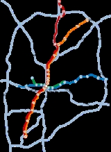
's heavy rail network is composed of four service lines: the Red Line
, Gold Line
, Blue Line
and the Green Line
. The lines connect at the Five Points station
and is the only station that provides connection from the group of the two lines that run mainly in opposite directions.
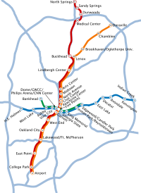 The Red and Gold lines split north of the Lindbergh Center Station
(stop N6). Northbound trains are identified by their destinations (North Springs
or Doraville
) on electronic LCD signs on the front and sides of the train and on each car. An automated announcement system announces train destinations, connections to bus routes at each station, connections to other rail lines, and other landmarks that apply to each rail station. During daytime hours, trains from both lines service the entire trunk line (N6 to S7); all southbound trains are identified with a destination of Airport
. After 7pm on weekdays and weekends only Doraville bound trains service N6 to S7. As a result, riders must transfer to or from a North Springs train at Lindbergh Center (N6).
The Blue and Green lines split at Ashby Station
(stop W3). Trains are identified by their final destination. Trains from H.E. Holmes
(W5) travel to Indian Creek Station
(E9). Normally, trains originating at Bankhead Station
(stop P4) travel to Edgewood/Candler Park Station
(stop E4). After 7pm on weekdays and weekends, trains originating at Bankhead Station only go so far as Vine City Station
(stop W2).
MARTA switched to a color-based naming system in October 2009. Previous maps of the MARTA system use orange to label the North-South line and blue to label the East-West line. Newer maps currently appear on trains, at stations, and on the system's website to further differentiate the different branches of the North-South and East-West Corridors with different colors (North Springs/Airport-red, Doraville/Airport-gold, H.E. Holmes-Indian Creek-blue, Proctor Creek/Edgewood-green).
Many suburb
an stations offer designated free daily and paid long term parking in MARTA operated park and ride
lots. These stations also have designated kiss ride passenger drop off parking spaces closest to the station entrance.
Metropolitan Atlanta Rapid Transit Authority
The Metropolitan Atlanta Rapid Transit Authority or MARTA is the principal rapid-transit system in the Atlanta metropolitan area and the ninth-largest in the United States. Formed in 1971 as strictly a bus system, MARTA operates a network of bus routes linked to a rapid transit system consisting...
's heavy rail network is composed of four service lines: the Red Line
Red Line (MARTA)
The Red Line is a rapid transit line in the MARTA rail system. It operates between North Springs and Airport stations, running through Sandy Springs, Atlanta, East Point and College Park....
, Gold Line
Gold Line (MARTA)
The Gold Line is a rapid transit line in the MARTA rail system. It operates between Doraville and Airport stations, running through Doraville, Chamblee, Atlanta, East Point and College Park....
, Blue Line
Blue Line (MARTA)
The Blue Line is a rapid transit line in the MARTA rail system. It operates between Hamilton E. Holmes and Indian Creek stations, running through Atlanta, Decatur and portions of unincorporated DeKalb County....
and the Green Line
Green Line (MARTA)
The Green Line is a rapid transit line in the MARTA rail system. It operates between Bankhead and Edgewood/Candler Park stations, running exclusively inside the Atlanta city limits....
. The lines connect at the Five Points station
Five Points (MARTA station)
Five Points is a tri-level underground multi-platform metro station of the Metropolitan Atlanta Rapid Transit Authority rail system. It is the transfer point between the Red and Gold Lines and the Blue and Green Lines and serves as MARTA's transportation hub. It provides access to the Five Points...
and is the only station that provides connection from the group of the two lines that run mainly in opposite directions.
Rail System
Lindbergh Center (MARTA station)
Lindbergh Center station is an at-grade Train station on the Red and Gold lines of the Metropolitan Atlanta Rapid Transit Authority rail system in the Lindbergh/Morosgo neighborhood in southern Buckhead. This is a partime terminus of the Red Line and the last transfer point for the Red and Gold ...
(stop N6). Northbound trains are identified by their destinations (North Springs
North Springs (MARTA station)
North Springs is an elevated metro station in the Metropolitan Atlanta Rapid Transit Authority rail system and the northern terminus for the Red Line...
or Doraville
Doraville (MARTA station)
Doraville is an elevated metro station and the northern terminus on the Gold Line of the Metropolitan Atlanta Rapid Transit Authority rail system, located in Doraville, Georgia...
) on electronic LCD signs on the front and sides of the train and on each car. An automated announcement system announces train destinations, connections to bus routes at each station, connections to other rail lines, and other landmarks that apply to each rail station. During daytime hours, trains from both lines service the entire trunk line (N6 to S7); all southbound trains are identified with a destination of Airport
Airport (MARTA station)
Airport is an elevated Rail station and southern terminus on the Red and Gold lines of the Metropolitan Atlanta Rapid Transit Authority rail system. It is served by the Gold Line at all times. It has an island platform between two tracks. This station is the southern terminus of the North-South...
. After 7pm on weekdays and weekends only Doraville bound trains service N6 to S7. As a result, riders must transfer to or from a North Springs train at Lindbergh Center (N6).
The Blue and Green lines split at Ashby Station
Ashby (MARTA station)
Ashby is an underground metro station on the Blue and Green lines of the Metropolitan Atlanta Rapid Transit Authority rail system.The area it serves was an important mini-downtown from the 1880s until the 1950s, centered on West Hunter St. and Ashby St....
(stop W3). Trains are identified by their final destination. Trains from H.E. Holmes
H.E. Holmes (MARTA station)
Hamilton E. Holmes is an elevated metro station in the Metropolitan Atlanta Rapid Transit Authority rail system, and the western terminus for the Blue Line. This is one of the busiest stations in the MARTA system, handling an average of 22,000 boardings per weekday...
(W5) travel to Indian Creek Station
Indian Creek (MARTA station)
Indian Creek is an at-grade terminus station on the Blue Line of the Metropolitan Atlanta Rapid Transit Authority rail system that serves a portion of DeKalb County, Georgia just outside of Interstate 285. It has an island platform with 1 track on each side of the platform...
(E9). Normally, trains originating at Bankhead Station
Bankhead (MARTA station)
Bankhead is an elevated metro station in the MARTA rail system and the western terminus of the Green Line , which was originally planned to serve points north beyond Bankhead such as Perry Homes. It is the only station served exclusively by the Green Line. This stations primarily serves the...
(stop P4) travel to Edgewood/Candler Park Station
Edgewood/Candler Park (MARTA station)
Edgewood / Candler Park is an at grade train station on the Blue and is a part-time terminus station on the Green lines of the Metropolitan Atlanta Rapid Transit Authority rail system. It has Single island platform with two tracks. This station was opened on June 30, 1979...
(stop E4). After 7pm on weekdays and weekends, trains originating at Bankhead Station only go so far as Vine City Station
Vine City (MARTA station)
Vine City is an at-grade train station on the Blue and part-time terminus station of Green lines of the Metropolitan Atlanta Rapid Transit Authority rail system. It is one of only 2 stations served by the Green, and Blue lines at all times...
(stop W2).
MARTA switched to a color-based naming system in October 2009. Previous maps of the MARTA system use orange to label the North-South line and blue to label the East-West line. Newer maps currently appear on trains, at stations, and on the system's website to further differentiate the different branches of the North-South and East-West Corridors with different colors (North Springs/Airport-red, Doraville/Airport-gold, H.E. Holmes-Indian Creek-blue, Proctor Creek/Edgewood-green).
Many suburb
Suburb
The word suburb mostly refers to a residential area, either existing as part of a city or as a separate residential community within commuting distance of a city . Some suburbs have a degree of administrative autonomy, and most have lower population density than inner city neighborhoods...
an stations offer designated free daily and paid long term parking in MARTA operated park and ride
Park and ride
Park and ride facilities are car parks with connections to public transport that allow commuters and other people wishing to travel into city centres to leave their vehicles and transfer to a bus, rail system , or carpool for the rest of their trip...
lots. These stations also have designated kiss ride passenger drop off parking spaces closest to the station entrance.
Stations
† denotes terminal station| Station | Code | Lines | Jurisdiction | Opened | Reference |
|---|---|---|---|---|---|
| Airport Airport (MARTA station) Airport is an elevated Rail station and southern terminus on the Red and Gold lines of the Metropolitan Atlanta Rapid Transit Authority rail system. It is served by the Gold Line at all times. It has an island platform between two tracks. This station is the southern terminus of the North-South... † |
S7 | Atlanta | |||
| Arts Center Arts Center (MARTA station) The Arts Center Station is an underground metro station on the Red and Gold lines of the Metropolitan Atlanta Rapid Transit Authority rail system.... |
N5 | Atlanta | |||
| Ashby Ashby (MARTA station) Ashby is an underground metro station on the Blue and Green lines of the Metropolitan Atlanta Rapid Transit Authority rail system.The area it serves was an important mini-downtown from the 1880s until the 1950s, centered on West Hunter St. and Ashby St.... |
W3 | Atlanta | |||
| Avondale Avondale (MARTA station) Avondale is an at-grade train station on the Blue Line of the Metropolitan Atlanta Rapid Transit Authority rail system . It serves Avondale Estates, Georgia , Clarkston, and the communities of Druid Hills, Scottsdale, Tucker, Northlake and North Decatur... |
E7 | Decatur Decatur, Georgia Decatur is a city in, and county seat of, DeKalb County, Georgia, United States. With a population of 19,335 in the 2010 census, the city is sometimes assumed to be larger since multiple zip codes in unincorporated DeKalb County bear the Decatur name... |
|||
| Bankhead Bankhead (MARTA station) Bankhead is an elevated metro station in the MARTA rail system and the western terminus of the Green Line , which was originally planned to serve points north beyond Bankhead such as Perry Homes. It is the only station served exclusively by the Green Line. This stations primarily serves the... † |
P4 | Atlanta | |||
| Brookhaven/Oglethorpe Brookhaven/Oglethorpe (MARTA station) Brookhaven/Oglethorpe is an elevated metro station on the Gold Line of the Metropolitan Atlanta Rapid Transit Authority rail system, located in Brookhaven, Georgia... |
NE8 | Atlanta | |||
| Buckhead Buckhead (MARTA station) Buckhead is an at-grade Train station on the Red Line of the Metropolitan Atlanta Rapid Transit Authority rail system. This station is the first station not served by the Gold Line. It is located in the median of State Route 400, a limited access highway, at Peachtree Road... |
N7 | Atlanta | |||
| Chamblee Chamblee (MARTA station) Chamblee is an elevated metro station on the Gold Line of the Metropolitan Atlanta Rapid Transit Authority rail system that provides access to the Chamblee, Georgia, area.... |
NE9 | Chamblee Chamblee, Georgia As of the 2010 Census Chamblee had a population of 9,892. The racial and ethnic composition of the population was 45.0% white , 7.0% black or African American , 2.1% Native American , 1.8% Vietnamese, 1.6% Asian Indian, 4.6% other Asian, 33.5% from some other race and... |
|||
| Civic Center Civic Center (MARTA station) Civic Center is an elevated metro station on the Red and Gold lines of the Metropolitan Atlanta Rapid Transit Authority rail system. It is located in the SoNo district of Atlanta... |
N2 | Atlanta | |||
| College Park College Park (MARTA station) College Park is an at-grade Rail station on the Red and Gold lines of the Metropolitan Atlanta Rapid Transit Authority rail system. This is the fourth busiest station in the MARTA system. It opened on June 18, 1988... |
S6 | Atlanta | |||
| Decatur Decatur (MARTA station) Decatur is an underground Train station on the Blue Line of the Metropolitan Atlanta Rapid Transit Authority rail system in the heart of Decatur, Georgia. It Serves Downtown Decatur, South Decatur, and South Dekalb. This station was opened on June 30, 1979. In 2005, a major renovation of the... |
E6 | Decatur Decatur, Georgia Decatur is a city in, and county seat of, DeKalb County, Georgia, United States. With a population of 19,335 in the 2010 census, the city is sometimes assumed to be larger since multiple zip codes in unincorporated DeKalb County bear the Decatur name... |
|||
| Dome/GWCC/Philips Arena/CNN Center Dome/GWCC/Philips Arena/CNN Center (MARTA station) Dome / GWCC / Philips Arena / CNN Center is an at-grade rail station on the Blue and Green lines of the Metropolitan Atlanta Rapid Transit Authority rail system. As the station name suggests, the station provides service to the Georgia Dome, the Georgia World Congress Center, Philips Arena, and... |
W1 | Atlanta | |||
| Doraville Doraville (MARTA station) Doraville is an elevated metro station and the northern terminus on the Gold Line of the Metropolitan Atlanta Rapid Transit Authority rail system, located in Doraville, Georgia... † |
NE10 | Doraville Doraville, Georgia Doraville is a city in DeKalb County, Georgia, United States, northeast of Atlanta. As of the 2010 census, the city had a population of 8,330.-History:Doraville was incorporated by an act of the Georgia General Assembly, approved December 15, 1871... |
|||
| Dunwoody Dunwoody (MARTA station) Dunwoody is an elevated metro station on the Red Line of the Metropolitan Atlanta Rapid Transit Authority rail system. It is located at the southwest corner of Perimeter Mall, and also serves the surrounding high-rise office parks in the Perimeter Center business district... |
N9 | Sandy Springs Sandy Springs, Georgia Sandy Springs is a city in north Georgia, United States. It is a northern suburb of Atlanta. With a 2010 population of 93,853, Sandy Springs is the sixth-largest city in the state and the second-largest city in Metro Atlanta. Sandy Springs is located in north Fulton County, Georgia, just south of... |
|||
| East Lake East Lake (MARTA station) East Lake is an at-grade Train station on the Blue Line of the Metropolitan Atlanta Rapid Transit Authority rail system. It has a island platform and two tracks that serve the platform in each direction. This station was opened on June 30, 1979. MARTA's opening cermonies and speeches took place in... |
E5 | Atlanta | |||
| East Point East Point (MARTA station) East Point is an at-grade Rail station on the Red and Gold lines of the Metropolitan Atlanta Rapid Transit Authority rail system, located in East Point, Georgia, USA. It has an island platform between two tracks. It was opened on August 16, 1986.... |
S5 | East Point East Point, Georgia The city of East Point is southwest of the neighborhoods of Atlanta in Fulton County, Georgia, United States. As of the 2010 census, the city had a population of 33,712... |
|||
| Edgewood/Candler Park Edgewood/Candler Park (MARTA station) Edgewood / Candler Park is an at grade train station on the Blue and is a part-time terminus station on the Green lines of the Metropolitan Atlanta Rapid Transit Authority rail system. It has Single island platform with two tracks. This station was opened on June 30, 1979... |
E4 | Atlanta | |||
| Five Points Five Points (MARTA station) Five Points is a tri-level underground multi-platform metro station of the Metropolitan Atlanta Rapid Transit Authority rail system. It is the transfer point between the Red and Gold Lines and the Blue and Green Lines and serves as MARTA's transportation hub. It provides access to the Five Points... * |
– | Atlanta | (East-West) (North-South) |
||
| Garnett Garnett (MARTA station) Garnett is an elevated Rail station on the Red and Gold lines of the Metropolitan Atlanta Rapid Transit Authority rail system, located in South Downtown. It has an island platform between two tracks. This station has three levels to it. It was opened on December 4, 1981... |
S1 | Atlanta | |||
| Georgia State Georgia State (MARTA station) Georgia State is an at-grade station on the Blue and part-time on the Green lines of the Metropolitan Atlanta Rapid Transit Authority rail system located in the eastern part of Downtown Atlanta. The station is located within the James H. Floyd State Office Building and was constructed... |
E1 | Atlanta | |||
| H. E. Holmes† | W5 | Atlanta | |||
| Indian Creek Indian Creek (MARTA station) Indian Creek is an at-grade terminus station on the Blue Line of the Metropolitan Atlanta Rapid Transit Authority rail system that serves a portion of DeKalb County, Georgia just outside of Interstate 285. It has an island platform with 1 track on each side of the platform... † |
E9 | Stone Mountain Stone Mountain, Georgia Stone Mountain is a city in eastern DeKalb County, Georgia, United States. The population was 5,802 at the 2010 census. It is an outer suburb of the Atlanta Metropolitan Area.-Geography:... |
|||
| Inman Park/Reynoldstown Inman Park/Reynoldstown (MARTA station) Inman Park / Reynoldstown is an at-grade station on the Blue and part-time on the Green lines of the Metropolitan Atlanta Rapid Transit Authority rail system it has two side platforms and 2 tracks. This station opened June 30, 1979. It is located adjacent to Freedom Park, Inman Park and Reynoldstown... |
E3 | Atlanta | |||
| Kensington Kensington (MARTA station) Kensington is an at-grade train station on the Blue Line of the Metropolitan Atlanta Rapid Transit Authority rail system that serves a central part of DeKalb County, Georgia. It is located on Memorial Drive and Kensington Road near the Kensington Office Park and in walking distance away from the... |
E8 | Decatur Decatur, Georgia Decatur is a city in, and county seat of, DeKalb County, Georgia, United States. With a population of 19,335 in the 2010 census, the city is sometimes assumed to be larger since multiple zip codes in unincorporated DeKalb County bear the Decatur name... |
|||
| King Memorial King Memorial (MARTA station) King Memorial is an elevated station on the Blue and part-time on the Green lines of the Metropolitan Atlanta Rapid Transit Authority rail system located in the Old Fourth Ward, near Oakland Cemetery. The station name is a portmanteau of Martin Luther King and nearby Memorial Drive. It provides... |
E2 | Atlanta | |||
| Lakewood/Fort McPherson Lakewood/Fort McPherson (MARTA station) Lakewood / Fort McPherson is an at-grade Rail station on the Red and Gold lines of the Metropolitan Atlanta Rapid Transit Authority rail system. It has an island platform between two tracks. It was opened on December 15, 1984. The set up for this station is like many on the East-West line... |
S4 | Atlanta | |||
| Lenox Lenox (MARTA station) Lenox is an underground metro station on the Gold Line of the Metropolitan Atlanta Rapid Transit Authority. It provides access to Lenox Mall, Phipps Plaza,and Buckhead Business District... |
NE7 | Atlanta | |||
| Lindbergh Center Lindbergh Center (MARTA station) Lindbergh Center station is an at-grade Train station on the Red and Gold lines of the Metropolitan Atlanta Rapid Transit Authority rail system in the Lindbergh/Morosgo neighborhood in southern Buckhead. This is a partime terminus of the Red Line and the last transfer point for the Red and Gold ... |
N6 | Atlanta | |||
| Medical Center Medical Center (MARTA station) Medical Center is an at-grade metro station on the Red Line of the Metropolitan Atlanta Rapid Transit Authority rail system. It serves the Pill Hill neighborhood of Perimeter Center, the location of Northside Hospital , St... |
N8 | Sandy Springs Sandy Springs, Georgia Sandy Springs is a city in north Georgia, United States. It is a northern suburb of Atlanta. With a 2010 population of 93,853, Sandy Springs is the sixth-largest city in the state and the second-largest city in Metro Atlanta. Sandy Springs is located in north Fulton County, Georgia, just south of... |
|||
| Midtown Midtown (MARTA station) Midtown is an underground metro station on the Red and Gold lines of the Metropolitan Atlanta Rapid Transit Authority rail system located in Midtown Atlanta. As of April 2006, 4,085 daily fares were collected at the gates... |
N4 | Atlanta | |||
| North Avenue North Avenue (MARTA station) North Avenue is an underground train station on the Red and Gold lines of the Metropolitan Atlanta Rapid Transit Authority rail system, named after the nearby North Avenue. The walls are made of white tile and painted with a mural of green hills, a blue sky, and clouds. It is among the busiest... |
N3 | Atlanta | |||
| North Springs North Springs (MARTA station) North Springs is an elevated metro station in the Metropolitan Atlanta Rapid Transit Authority rail system and the northern terminus for the Red Line... † |
N11 | Sandy Springs Sandy Springs, Georgia Sandy Springs is a city in north Georgia, United States. It is a northern suburb of Atlanta. With a 2010 population of 93,853, Sandy Springs is the sixth-largest city in the state and the second-largest city in Metro Atlanta. Sandy Springs is located in north Fulton County, Georgia, just south of... |
|||
| Oakland City Oakland City (MARTA station) Oakland City is an elevated Rail station on the Red and Gold lines of the Metropolitan Atlanta Rapid Transit Authority rail system. It has one island platform between two tracks. It was opened on December 15, 1984. For both entrances to this station, you have to go through the fare gates and an... |
S3 | Atlanta | |||
| Peachtree Center Peachtree Center (MARTA station) Peachtree Center station is an underground Train station on the Red and Gold lines of the Metropolitan Atlanta Rapid Transit Authority rail system. It is the deepest station in the MARTA rail system, at below Peachtree Street. It serves the Peachtree Center area of downtown Atlanta, and is the... |
N1 | Atlanta | |||
| Sandy Springs Sandy Springs (MARTA station) Sandy Springs is an underground metro station on the Red Line of the Metropolitan Atlanta Rapid Transit Authority rail system. It serves the Perimeter Center area, including high-rise office parks near Georgia 400 and Abernathy Road, north of Perimeter Mall and within the recently-incorporated... |
N10 | Sandy Springs Sandy Springs, Georgia Sandy Springs is a city in north Georgia, United States. It is a northern suburb of Atlanta. With a 2010 population of 93,853, Sandy Springs is the sixth-largest city in the state and the second-largest city in Metro Atlanta. Sandy Springs is located in north Fulton County, Georgia, just south of... |
|||
| Vine City Vine City (MARTA station) Vine City is an at-grade train station on the Blue and part-time terminus station of Green lines of the Metropolitan Atlanta Rapid Transit Authority rail system. It is one of only 2 stations served by the Green, and Blue lines at all times... |
W2 | Atlanta | |||
| West End West End (MARTA station) West End is an elevated Rail station on the Red and Gold lines of the Metropolitan Atlanta Rapid Transit Authority rail system servicing the West End and most of Southwest Atlanta, including neighborhoods bordering Cascade Road and Metropolitan Parkway. The West End station opened on September... |
S2 | Atlanta | |||
| West Lake West Lake (MARTA station) West Lake is an at-grade metro station on the Blue Line of the Metropolitan Atlanta Rapid Transit Authority rail system. It serves the area near Westview Cemetery. The station is located between West Lake & Anderson Avenues in West Atlanta... |
W4 | Atlanta |
Historical timeline
This is a list of key dates which led to the formation of the MARTA stations along the established rapid rail lines.- June 30, 1979 -- MARTA's first train, the East Line, began operating between Avondale and Five Points Station. It also marked the start of MARTA's combined bus and rail service.
- December 22, 1979 -- MARTA's second train, the West Line, began operating between Hightower (H.E. Holmes) and Five Points Station.
- September 1982 -- the Peachtree Center and West End stations, along the North Line began service.
- December 1982 -- the Arts Center and Midtown stations began service.
- December 1984 -- five new stations opened: Lindbergh Center, Lenox, Brookhaven, Oakland City and Lakewood/Fort McPherson. The South Line was introduced.
- August 1986 -- the East Point Station opened, extending the South Line by about two miles. A little more than a year later, the Chamblee Station began service and served as the temporary end of the Northeast Line.
- June 18, 1988 --- the Airport Station opens, and becomes the southern termini of the North-South Line.
- December 12, 1992 -- The Bankhead Station/Proctor Creek Line went into service.
- December 29, 1992 -- The Doraville Station opens and becomes the northern termini of the Northeast Line.
- June 26, 1993 -- MARTA extended East Line services through Kensington to Indian Creek Station - the first time the rail line went beyond the I-285 perimeter.
- June 8, 1996 -- MARTA extended North Line services through Buckhead, Medical Center and Dunwoody Stations.
- 1999 -- MARTA announced a partnership with BellSouth to create the Lindbergh Transit Oriented Development (TOD), a live, work and play community built around a rail station and the largest multi-use development of its kind in the United States at the time.
- December 16, 2000 -- MARTA opened two new rail stations - Sandy Springs and North Springs -on the North Line.
- October 1, 2009 -- MARTA renames its lines based on colors instead of directions.
- February 2010 -- MARTA agrees to rename the Yellow Line as the Gold Line in response to outcry from members of the Doraville Asian community.