

List of Hewitts in Ireland
Encyclopedia
Ireland
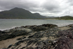
Ireland is an island to the northwest of continental Europe. It is the third-largest island in Europe and the twentieth-largest island on Earth...
that are at least 2000 feet (609.6 m) high with a relative height of at least 30 m. The original list, covering only England and Wales, was compiled by Alan Dawson and originally published in The Relative Hills of Britain under the name Sweats. The list was subsequently renamed Hewitts to include Ireland, updated, and published in a series of three booklets edited by Dave Hewitt: The Hewitts and Marilyns of Wales, The Hewitts and Marilyns of England and The Hewitts and Marilyns of Ireland.
This list concerns the Hewitts in the Republic of Ireland
Republic of Ireland
Ireland , described as the Republic of Ireland , is a sovereign state in Europe occupying approximately five-sixths of the island of the same name. Its capital is Dublin. Ireland, which had a population of 4.58 million in 2011, is a constitutional republic governed as a parliamentary democracy,...
.
- Carrauntoohil — 1,038 m
- Cnoc na PéisteCnoc na PéisteCnoc na Péiste—often anglicised as Knocknapeasta and more rarely given as Slievenapeesta or Cummeennapeasta—is a 988 m mountain peak in County Kerry, Republic of Ireland...
— 988 m - Brandon MountainMount BrandonMount Brandon or Brandon Mountain is a 952 m mountain on the Dingle Peninsula in County Kerry, Republic of Ireland. It is the highest peak of the unnamed central mountain range of the Dingle Peninsula and the ninth highest peak in Ireland...
— 951 m - LugnaquillaLugnaquillaLugnaquilla or Lugnaquillia, historically called Lugnaculliagh is a mountain in County Wicklow, Republic of Ireland. It is the highest peak of the Wicklow Mountains range, the highest in the province of Leinster, and the 13th highest peak in Ireland and affectionately known as "Lug".Views, on a...
— 924 m - Galtymore — 917 m
- BaurtregaumBaurtregaumBaurtregaum or Bartregaum is a 851 m mountain peak in County Kerry, Republic of Ireland. It is the highest of the Slieve Mish Mountains and the 17th highest peak in Ireland....
— 851 m - MullaghcleevaunMullaghcleevaunMullaghcleevaun is a mountain in County Wicklow, Republic of Ireland. At 849 m tall, it is the second highest of the Wicklow Mountains and the 20th highest in Ireland....
— 849 m - Mangerton MountainMangerton MountainMangerton or Mangerton Mountain is a mountain in County Kerry, Republic of Ireland. At a height of 839 m it is the tallest of the Mangerton range and 25th tallest in Ireland...
— 843 m - Brandon Peak — 840 m
- Purple Mountain — 832 m
- BeenoskeeBeenoskeeBeenoskee or Benoskee is a 826 m mountain on the Dingle Peninsula in County Kerry, Republic of Ireland. Part of the Dingle Mountains, it is the highest of the "Central Dingle" group and the 28th highest in Ireland....
— 826 m - TonelageeTonelageeTonelagee is a mountain with a height of 817 m in County Wicklow, Republic of Ireland. It lies just north of the high point of the Wicklow Gap in the centre of the Wicklow Mountains. Tonelagee is the third highest of the Wicklow Mountains and the 33rd highest peak in Ireland...
— 817 m - MweelreaMweelreaMweelrea is a mountain in County Mayo, Republic of Ireland. With a height of 814 metres , it is the highest point in County Mayo, the highest point in the province of Connacht and the 34th highest in Ireland...
— 814 m - NephinNephinNephin or Nefin , at 806 metres , is the second highest peak in County Mayo and the second highest in Connacht, in Ireland...
— 806 m - Ben Lugmore — 803 m
- Greenane — 802 m
- KnockmealdownKnockmealdownKnockmealdown is the highest peak of the Knockmealdown Range of mountains, located on the border between Co Tipperary and Co Waterford. The peak itself is located in County Waterford and is the highest point in that county. However, since the county border generally follows the summit line the...
— 794 m - Mount LeinsterMount LeinsterAt 796 metres Mount Leinster is the fifth highest mountain after Lugnaquilla 925m, Mullaghcleevaun 849m, Tonelegee 817m, and Cloghernagh 800m, in the province of Leinster, Ireland. It is the highest of the Blackstairs Mountains at 796 metres...
— 793 m - Over FauscoumOver FauscoumFauscoum is a mountain in County Waterford, Ireland. It is the highest mountain of the Comeragh Mountain Range and the second highest mountain in County Waterford after Knockmealdown.- References :* . Mountainviews.ie....
— 792 m - Temple HillTemple Hill (Ireland)- References :*...
— 785 m - Stumpa Duloigh — 784 m
- Mullaghanattin — 773 m
- BarrclashcameBarrclashcameBarrclashcame is a 772 m mountain in County Mayo, Republic of Ireland. It is within the townland of Clashcame and is the highest peak of the Sheeffry Hills....
— 772 m - Coomacarrea — 772 m
- Croagh PatrickCroagh PatrickCroagh Patrick , nicknamed the Reek, is a tall mountain and an important site of pilgrimage in County Mayo, Republic of Ireland. It is from Westport, above the villages of Murrisk and Lecanvey. It is the third highest mountain in County Mayo after Mweelrea and Nephin. On "Reek Sunday", the last...
— 764 m - KippureKippureKippure is a granite mountain that straddles the county boundaries of South Dublin and Wicklow. It is popular for hill walking and outdoor leisure activity owing to its proximity to Dublin city, with its fine views over Dublin Bay towards Howth Head. It has convenient access and easy terrain...
— 757 m - Knockanaffrin — 755 m
- Beann — 752 m
- Errigal MountainMount ErrigalMount Errigal, or simply Errigal is a mountain near Gweedore in County Donegal, Republic of Ireland. It is the tallest peak of the Derryveagh Mountains, the tallest peak in County Donegal, and the 76th tallest peak in Ireland. Errigal is also the most southern, steepest and highest of the...
— 749 m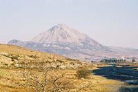
- Broaghnabinnia — 745 m
- Blackstairs MountainBlackstairs MountainBlackstairs Mountain in southern Leinster, is the second-highest mountain in the Blackstairs Mountains....
— 732 m - BenbaunBenbaunBenbaun is a mountain in County Galway, Ireland, the highest of the Twelve Bens, and the highest peak in Galway. As the highest point in Galway, it is the 10th highest county peak in Ireland....
— 729 m - DjouceDjouceDjouce , sometimes referred to as Djouce Mountain, is a mountain situated in the northeastern section of the Wicklow Mountains. To the west it overlooks the highlands around the Sally Gap; to the east the Roundwood / Calary Bog plateau....
— 725 m - Slieve Cor — 721 m
- SlievenamonSlievenamonSlievenamon is a mountain in County Tipperary in the province of Munster in Ireland. It stands at 721 m . It is located in the south of the county, near the town of Clonmel...
— 721 m - Corranabinnia — 716 m
- BencorrBencorrBencorr is a mountain in Galway, Ireland. With a height of 711 metres it is the second highest mountain in the Twelve Bens after Benbaun and the 101st highest summit in Ireland. It is the second highest mountain in Galway. Englishman Tim Robinson gave this mountain the alternative name of Binn an...
— 711 m - KnockboyKnockboyKnockboy is a 706-metre-high mountain on the border between counties Cork and Kerry in Ireland. It is the highest peak in the Shehy mountain range and the highest mountain in County Cork with its summit shared with County Kerry. It is the 104th highest peak in Ireland...
— 706 m - BarrslievenaroyBarrslievenaroyBarrslievenaroy —also called Binn idir an Dá Log— is a 702 m mountain in County Galway, Republic of Ireland. It is the highest of the Maumturks range, which lie within the Connemara region....
— 702 m - Ben GormBen Gorm- References :*...
— 700 m - Birreencorragh — 698 m
- CamaderryCamaderryCamaderry is a mountain in the Wicklow Mountains, just south of the Wicklow Gap in County Wicklow, which runs over the gap between it and Tonelagee Mountain...
— 698 m - Bencollaghduff — 696 m
- Slievekimalta — 694 m
- The Paps (East) — 694 m
- Benbreen — 691 m
- Knocknadobar — 690 m
- CroaghaunCroaghaunCroaghaun is a mountain in County Mayo, Ireland. At 688 metres , it has the highest cliffs in Ireland and the second highest sea cliffs in Europe ....
— 688 m - War HillWar HillWar Hill is a mountain in County Wicklow, Ireland. At 686 metres it is the 20th highest mountain in the Wicklow Mountains and the 129th highest summit in Ireland.-References:...
— 686 m - Hungry HillHungry HillHungry Hill is a 685 m, 2248 ft mountain on the Beara Peninsula in the Republic of Ireland. It is the highest peak of the Caha Mountains and the 130th highest in Ireland...
— 685 m - KnockmoyleKnockmoyleKnockmoyle is a hamlet and townland about 8 kilometres northwest of Omagh in County Tyrone, Northern Ireland. In the 2001 census the Knockmoyle area had 141 households and a population of 329. It has a post office, church and public house. The nearby River Strule is well known for its trout fishing...
— 684 m - MaumtrasnaMaumtrasnaMaumtrasna is a mountain in County Mayo, Ireland.The name derives from its Irish name which is roughly translated as the "Mountain pass crossing".- References :*...
— 682 m - Caherbarnagh — 681 m
- Slieve SnaghtSlieve SnaghtSlieve Snaght is a mountain in Inishowen, County Donegal, Ireland, not to be confused with the mountain of the same name in the nearby Derryveagh range.- References :* *...
— 678 m - Coomcallee — 675 m
- CroaghgormCroaghgormCroaghgorm or Bluestack is a 674 m mountain in County Donegal, Ireland. It is the highest of the Bluestack Mountains and the third-highest mountain in County Donegal....
— 674 m - Lavagh More — 671 m
- SlievemoreSlievemoreSlievemore is the second highest peak on Achill Island, in County Mayo, Ireland. Its elevation is 671 metres.-Archaeology:* Achill Archaeological Field School is based at the Achill Archaeology Centre in Dooagh. It was founded in 1991 and is a training school for students of archaeology and...
— 671 m - Slievanea — 670 m
- Knocknafallia — 668 m
- Letterbreckaun — 667 m
- Muckish MountainMuckishMuckish is a distinctive flat-topped mountain in the Derryveagh Mountains of County Donegal, Republic of Ireland. At , it is the third-highest peak in the Derryveagh Mountains and the 163rd highest in Ireland. Muckish is also the most northern and second highest of the mountain chain called the...
— 666 m
- CuilcaghCuilcaghCuilcagh, historically Slieve Cuilcagh , is the highest mountain in the Breifne area and the 165th highest on the island of Ireland . The summit lies on the border between County Fermanagh and County Cavan , and is the highest point in both counties...
— 665 m - Bengower — 664 m
- Croaghanmoira Mountain — 664 m
- Sugarloaf HillSugarloaf Hill (Knockmealdowns)Sugarloaf Hill is a mountain peak located in the Knockmealdown Mountains on the border between South Tipperary and County Waterford.-See also:* List of mountains in Ireland* Sugarloaf...
— 663 m - Binn Mhor — 661 m
- Knockowen — 658 m
- Crohane — 656 m
- Muckanaght — 654 m
- Keadeen MountainKeadeen MountainKeadeen is a mountain of the Wicklow Mountains located in western County Wicklow located near Donard and Baltinglass, overlooking the Glen of Imaal to the north, Kiltegan to the south and Kilranelagh to the west...
— 653 m - DooishDooishDooish is a village and townland near Drumquin in County Tyrone, Northern Ireland. In the 2001 Census it had a population of 93 people. It lies within the Omagh District Council area.-References:*...
— 652 m - Knockshanahullion — 652 m
- MullaghanishMullaghanishMullaghanish is a mountain located just northeast of Ballyvourney in County Cork, Ireland. It is home to one of RTÉ's main transmitters, as well as some other mobile phone and independent radio stations....
— 649 m - TruskmoreTruskmoreTruskmore is a 647 m mountain on the border of County Sligo and County Leitrim, Republic of Ireland. It is the highest peak of the Dartry Mountains and the highest in County Sligo....
— 647 m - DevilsmotherDevilsmotherDevilsmother , also known as Binn Gharbh , is a small mountain in Connemara, Ireland. It is just off the edge of the Maumturks chain and overlooks the Western Way long distance path....
— 645 m - Coomnadiha — 644 m
- MusheramoreMusheramoreMusheramore is a 644 m mountain in County Cork, Ireland. It is the highest of the Boggeragh Mountains.There are two holy wells on the mountain: one at the summit for sick animals and one on its northern slopes for humans....
— 644 m - Banoge North — 641 m
- Knocklomena — 641 m
- Scarr — 641 m
- Cnoc na gCapall — 639 m
- Cush — 639 m
- Knocknamanagh — 637 m
- Bencullagh — 632 m
- White Hill — 630 m
- Nephin BegNephin BegNephin Beg or Nefin Beg is a mountain in the Nephin Beg Range in north County Mayo, Ireland. The mountain takes its name from Nephin, although that mountain is some distance away and with intervening mountains between them The highest point is 365 meters....
— 627 m - Ballysitteragh — 623 m
- MaulinMaulinMaulin is a hill located in the northeastern section of the Wicklow Mountains, close to the border with County Dublin. It can be found on a side trail off the main Wicklow Way. It is readily accessible via well-marked trails from Crone Wood carpark, located south-west of Enniskerry...
— 621 m - Leenaun Hill — 618 m
- Slieve SnaghtSlieve SnaghtSlieve Snaght is a mountain in Inishowen, County Donegal, Ireland, not to be confused with the mountain of the same name in the nearby Derryveagh range.- References :* *...
— 615 m