

List of Georgia rivers (U.S. state)
Encyclopedia
River
A river is a natural watercourse, usually freshwater, flowing towards an ocean, a lake, a sea, or another river. In a few cases, a river simply flows into the ground or dries up completely before reaching another body of water. Small rivers may also be called by several other names, including...
s in Georgia (U.S. state)
Georgia (U.S. state)
Georgia is a state located in the southeastern United States. It was established in 1732, the last of the original Thirteen Colonies. The state is named after King George II of Great Britain. Georgia was the fourth state to ratify the United States Constitution, on January 2, 1788...
.
By drainage basinDrainage basinA drainage basin is an extent or an area of land where surface water from rain and melting snow or ice converges to a single point, usually the exit of the basin, where the waters join another waterbody, such as a river, lake, reservoir, estuary, wetland, sea, or ocean...
This list is arranged by drainage basin, with respective tributaries indented under each larger stream's name. Atlantic OceanAtlantic OceanThe Atlantic Ocean is the second-largest of the world's oceanic divisions. With a total area of about , it covers approximately 20% of the Earth's surface and about 26% of its water surface area...
- Savannah RiverSavannah RiverThe Savannah River is a major river in the southeastern United States, forming most of the border between the states of South Carolina and Georgia. Two tributaries of the Savannah, the Tugaloo River and the Chattooga River, form the northernmost part of the border...
- Black Creek
- Knoxboro CreekKnoxboro CreekThe Knoxboro Creek is a tributary of the Savannah River. It is located at the boundary between Effingham and Chatham counties in the Greater Savannah Area ....
- Ebenezer CreekEbenezer CreekEbenezer Creek is a location in Georgia where hundreds of freed black slaves were abandoned during General Sherman's march during the American Civil War. After the army had crossed over on pontoons the commander in charge of the crossing, BG Jefferson C. Davis, cut them loose, leaving the escaped...
- Brier CreekBrier CreekBrier Creek is a tributary of the Savannah River in the U.S. state of Georgia. It rises in Warren County east of Camak and flows southeast to the Savannah River in Screven County, east of Sylvania.- References :...
- Little River
- Kettle CreekKettle Creek (Georgia)Kettle Creek is a tributary of the Little River in Wilkes County, Georgia, in the United States. It is part of the Savannah River watershed.The Battle of Kettle Creek, an important battle in the American Revolutionary War, took place at this site....
- Kettle Creek
- Broad RiverBroad River (Georgia)The Broad River is a tributary of the Savannah River in northeastern Georgia. The North Fork of the Broad River begins in the foothills of the Appalachian Mountains in Stephens County, then joins the Middle Fork west of Royston in Franklin County to form the main stem. The Broad River continues...
- Hudson RiverHudson River (Georgia)The Hudson River is a tributary of the Broad River in the U.S. state of Georgia. Via the Broad River, it is part of the Savannah River watershed....
- Hudson River
- Tugaloo RiverTugaloo RiverThe Tugaloo River is a river bordering the U.S. states of Georgia and South Carolina. It is fed by the Tallulah River and the Chattooga River, which each form an arm of Lake Tugalo, on the edge of Georgia's Tallulah Gorge State Park. The Tugaloo then flows out of the lake via Tugaloo Dam,...
- Chattooga RiverChattooga RiverThe Chattooga River is the main tributary of the Tugaloo River. Its headwaters are located southwest of Cashiers, North Carolina, and it stretches to where it has its confluence with the Tallulah River within Lake Tugalo, held back by the Tugalo Dam...
- Tallulah RiverTallulah RiverThe Tallulah River is a river in Georgia and North Carolina. It begins in Clay County, North Carolina, near Standing Indian Mountain in the Southern Nantahala Wilderness and flows south into Georgia, crossing the state line into Towns County. The river then travels through Rabun County and ends in...
- Coleman RiverColeman RiverColeman River is a stream that is located in the Blue Ridge Mountains, mostly within Rabun County, Georgia. It is one of the main tributaries of the Tallulah River. The headwaters of Coleman River are located in Clay County, North Carolina, and the river travels a short distance before crossing...
- Coleman River
- Chattooga River
- Bull RiverBull River (Georgia)The Bull River is an tidal river in the U.S. state of Georgia, running through Chatham County east of Savannah. At its north end it connects via St. Augustine Creek and the Wilmington River with the Savannah River. Its south end is at Wassaw Sound, leading to the Atlantic Ocean...
- Shad RiverShad River (Georgia)The Shad River is a tidal river in the U.S. state of Georgia. It is a tributary of the Bull River and flows through salt marshes connected to Wilmington Island in Chatham County.- References :*USGS Hydrologic Unit Map - State of Georgia...
- Shad River
- Halfmoon RiverHalfmoon RiverThe Halfmoon River is a tidal river in the U.S. state of Georgia. It flows through saltmarshes connected to Wilmington Island in Chatham County, ending at Wassaw Sound, an arm of the Atlantic Ocean.- References :...
- Wilmington RiverWilmington River (Georgia)The Wilmington River is a tidal river in the U.S. state of Georgia. It flows through Chatham County along the east side of the city of Savannah. At its north end, it connects with the Savannah River, then travels southwest past Savannah, then turns southeast and ends in Wassaw Sound, an arm of...
- Skidaway RiverSkidaway RiverThe Skidaway River is an tidal river in the U.S. state of Georgia. It is located in Chatham County southeast of Savannah. Its north end is at the Wilmington River, and it flows southwest from there through Skidaway Narrows to end at the Burnside River, which connects via the Vernon and Little...
- Herb RiverHerb RiverThe Herb River is an tidal river in the U.S. state of Georgia. It is located in Chatham County, near the southeastern edge of Savannah. It connects with the Wilmington River to the north and the Moon River to the south, and it separates the mainland on the west from Isle of Hope and Dutch Island...
- Skidaway River
- Odingsell RiverOdingsell RiverThe Odingsell River is a tidal river in the U.S. state of Georgia. It flows into Ossabaw Sound just north of the mouth of the Ogeechee River. It passes through salt marshes lying between Skidaway Island to the west, Wassaw Island to the north and east, and Little Wassaw Island to the south.-...
- Ogeechee RiverOgeechee RiverOgeechee River is a river in the U.S. state of Georgia. It heads at the confluence of its North and South Forks, about south-southwest of Crawfordville and flowing generally southeast to Ossabaw Sound about south of Savannah. Its largest tributary is the Canoochee River...
- Little Ogeechee River (Chatham County)Little Ogeechee River (Chatham County)The Little Ogeechee River in Chatham County is one of two rivers by that name in the U.S. state of Georgia. Rising in southern Effingham County, the Little Ogeechee flows to the southeast and enters Chatham County, where it becomes tidal in the vicinity of its crossing by U.S. Route 17...
- Vernon RiverVernon River (Georgia)The Vernon River is a primarily tidal river in the U.S. state of Georgia. Located in Chatham County, it rises south of Hunter Army Airfield in Savannah and flows south into tidal marshes, where it joins the Little Ogeechee River southwest of Skidaway Island....
- Vernon River
- Canoochee RiverCanoochee RiverThe Canoochee River is a river in southeastern Georgia in the United States. It is a tributary of the Ogeechee River, which flows to the Atlantic Ocean.-Course:...
- Williamson Swamp CreekWilliamson Swamp CreekThe Williamson Swamp Creek is a tributary of the Ogeechee River in the U.S. state of Georgia. Rising in northwestern Washington County north of Sandersville, it flows southeast past Davisboro and enters Jefferson County, ending at the Ogeechee River southeast of Wadley.- References :*USGS...
- Rocky Comfort CreekRocky Comfort CreekRocky Comfort Creek is a tributary of the Ogeechee River in the U.S. state of Georgia. Rising in Warren County northwest of Warrenton, it flows southeast, entering Glascock County and passing the town of Gibson, then continuing south into Jefferson County, where it reaches the Ogeechee River at...
- Little Ogeechee River (Hancock County)Little Ogeechee River (Hancock County)The Little Ogeechee River in Hancock County is one of two rivers with that name in the U.S. state of Georgia. It rises in Hancock County northeast of Sparta and flows southeast into Washington County, passing through Hamburgh State Park and entering the Ogeechee River southwest of Mitchell. The...
- Little Ogeechee River (Chatham County)
- Bear RiverBear River (Georgia)The Bear River is a tidal river in the U.S. state of Georgia. It forms the channel that separates Ossabaw Island from the Georgia mainland, connecting with the Ogeechee River at its north end and the Medway River at its south.- References :...
- Medway RiverMedway River (Georgia)The Medway River is an tidal river in the U.S. state of Georgia. It is formed by the confluence of the Laurel View River with the smaller Belfast and Tivoli rivers, all three of which are tidal. It empties into St. Catherines Sound, an arm of the Atlantic Ocean...
- Belfast RiverBelfast River (Georgia)The Belfast River is a tidal channel in Bryan County, Georgia, in the United States. It is a northern side channel of the Laurel View River. At its seaward end where it rejoins the Laurel View, the two rivers form the Medway River, which continues to the Atlantic Ocean through St. Catherines...
- Tivoli RiverTivoli RiverThe Tivoli River is an primarily tidal river in Bryan County, Georgia, in the United States. It flows into the Belfast River, just north of that river's terminus at the Medway River, an arm of the Atlantic Ocean.- References :...
- Tivoli River
- Laurel View RiverLaurel View RiverThe Laurel View River is a tidal river in the U.S. state of Georgia. It is fed by the Jerico River, which splits into the Laurel View and Belfast rivers, and ends where the Belfast River rejoins it, forming the Medway River, which continues to the Atlantic Ocean...
- Jerico RiverJerico RiverThe Jerico River is a river on the Atlantic coastal plain in the U.S. state of Georgia. It serves as the boundary between Bryan and Liberty counties for its entire length....
- Jerico River
- Belfast River
- North Newport RiverNorth Newport RiverThe North Newport River is a tidal river in Liberty County in the U.S. state of Georgia. It rises just west of Interstate 95, south of Richmond Hill, and flows generally east-southeast to its mouth at the Medway River and St. Catherines Sound on the Atlantic Ocean....
- South Newport RiverSouth Newport RiverThe South Newport River is a river on the Atlantic coastal plain in the U.S. state of Georgia. It rises in Long County south of Walthourville and flows east-southeast, becoming the boundary between Liberty and McIntosh counties. It flows into Sapelo Sound, an arm of the Atlantic Ocean, south of St...
- Sapelo RiverSapelo RiverThe Sapelo River is a primarily tidal river in McIntosh County in the U.S. state of Georgia. It forms between Interstate 95 and U.S. Route 17 near the community of Eulonia and winds generally east through salt marshes into Sapelo Sound, an arm of the Atlantic Ocean that separates St...
- Broro RiverBroro RiverThe Broro River is a tidal arm of the Sapelo River in McIntosh County, Georgia, in the United States.- References :*USGS Hydrologic Unit Map - State of Georgia...
- Broro River
- Mud RiverMud River (Georgia)The Mud River is a tidal arm of the Sapelo River in McIntosh County, Georgia, in the United States. It forms the northern part of the channel separating Sapelo Island from the mainland.- References :*USGS Hydrologic Unit Map - State of Georgia...
- Crescent RiverCrescent River (Georgia)The Crescent River is a tidal river in McIntosh County, Georgia, in the United States. It forms in salt marshes east of the community of Bellville Point and flows southeast, ending at a river junction where the Mud River flows northeast into Sapelo Sound and Old Teakettle Creek flows south to...
- Crescent River
- Duplin RiverDuplin RiverThe Duplin River is an tidal river in McIntosh County, Georgia, in the United States. It flows from north to south along the western edge of Sapelo Island into Doboy Sound, an arm of the Atlantic Ocean.- References :...
- North RiverNorth River (Darien River)The North River is a tidal river channel, approximately long, in coastal Georgia, the United States. It is a longer and narrower alternative channel to the tidal Darien River and ultimately is part of the Altamaha River system in the marshes between Darien, Georgia and the Atlantic Ocean....
- South RiverSouth River (Darien River)The South River is a tidal channel in McIntosh County, Georgia, in the United States. It connects the Darien River to its west with Doboy Sound, an arm of the Atlantic Ocean, to its east. It flows through an extensive saltmarsh complex, with Queens Island to the north and Wolf Island to the...
- Darien RiverDarien River (Georgia)The Darien River is a tidal river in the U.S. state of Georgia, in the vicinity of the city of Darien. It is part of the large complex of salt marshes surrounding the mouth of the Altamaha River.- References :...
- Darien River
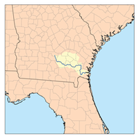
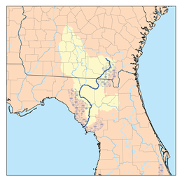
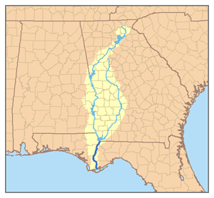
- Altamaha RiverAltamaha RiverThe Altamaha River is a major river of the American state of Georgia. It flows generally eastward for 137 miles from its origin at the confluence of the Oconee River and Ocmulgee River towards the Atlantic Ocean, where it empties into the ocean near Brunswick, Georgia. There are no dams...
- Ohoopee RiverOhoopee RiverThe Ohoopee River is a river in east-central Georgia in the United States. It is a tributary of the Altamaha River, which flows to the Atlantic Ocean.-Course:...
- Little Ohoopee River
- Ocmulgee RiverOcmulgee RiverThe Ocmulgee River is a tributary of the Altamaha River, approximately 255 mi long, in the U.S. state of Georgia...
- Little Ocmulgee RiverLittle Ocmulgee RiverThe Little Ocmulgee River is a tributary of the Ocmulgee River in the U.S. state of Georgia.- References :*USGS Hydrologic Unit Map - State of Georgia...
- Alligator Creek
- Gum Swamp Creek
- Tobesofkee CreekTobesofkee CreekTobesofkee Creek is a river in Georgia. It originates near Barnesville and flows roughly southeast across Lamar, Monroe, and Bibb counties to join the Ocmulgee River south of the city of Macon...
- Swift Creek
- Towaliga RiverTowaliga RiverThe Towaliga River is a tributary of the Ocmulgee River in central Georgia. The name, Towaliga, is of Creek origin and translates to "Roasted Scalp." The Creek Indians of the area were known to scalp their enemies and place their scalps on the large rocks by the river...
- Alcovy RiverAlcovy RiverThe Alcovy River is a tributary of the Ocmulgee River in north-central Georgia in the United States. Via the Ocmulgee River, it is part of the watershed of the Altamaha River, which flows to the Atlantic Ocean.-Course:...
- South RiverSouth River (Ocmulgee River)The South River is a tributary of the Ocmulgee River in the U.S. state of Georgia. It originates in the city of East Point in Fulton County and eventually flows into Lake Jackson, joining the Yellow River and the Alcovy River to form the Ocmulgee....
- Yellow RiverYellow River (Georgia)The Yellow River is a tributary of the Ocmulgee River in the U.S. state Georgia.The river rises north of Lawrenceville in Gwinnett County and flows south through the outer eastern suburbs of Atlanta, passing through the easternmost corner of DeKalb County before entering Rockdale County...
- Little Ocmulgee River
- Oconee RiverOconee RiverThe Oconee River is a river which has its origin in Hall County, Georgia, and terminates where it joins the Ocmulgee River to form the Altamaha River near Lumber City at the borders of Montgomery County, Wheeler County, and Jeff Davis County. South of Athens, two forks, known as the North Oconee...
- Little RiverLittle River (Oconee River)The Little River is a tributary of the Oconee River in the U.S. state of Georgia. It rises in Walton County near the city of Social Circle and flows southeast to join the Oconee River in Lake Sinclair.- References :...
- Apalachee RiverApalachee RiverThe Apalachee River is a tributary of the Oconee River in the U.S. state of Georgia. It rises north of Lawrenceville in eastern Gwinnett County and flows southeast to join the Oconee River in Lake Oconee west of Greensboro.- References :...
- Middle Oconee River
- Mulberry RiverMulberry River (Georgia)The Mulberry River is a tributary of the Middle Oconee River in the U.S. state of Georgia. It rises in southeastern Hall County and flows southeast, forming the boundary between Jackson and Barrow counties, to join the Middle Oconee south of Jefferson....
- Mulberry River
- North Oconee River
- Little River
- Ohoopee River
- Hampton RiverHampton River (Georgia)The Hampton River is a tidal river in Glynn County, Georgia. It forms the channel between Saint Simons Island and Little Saint Simons Island on the Atlantic coast.- References :*USGS Hydrologic Unit Map - State of Georgia...
- Frederica RiverFrederica RiverThe Frederica River is an tidal river in Glynn County, Georgia. It forms the western boundary of Saint Simons Island of the Georgia Sea Islands. Fort Frederica National Monument is located on the eastern bank of the river on Saint Simons Island....
- Mackay RiverMackay RiverThe Mackay River is a tidal river in Glynn County, Georgia. It flows between Saint Simons Island to the east and the mainland, including the city of Brunswick, to the west, and connects to Buttermilk Sound at its north end and St. Simons Sound and the Brunswick River at its south end. It runs...
- Brunswick RiverBrunswick River (Georgia)The Brunswick River is a tidal river in Georgia. It begins at the Sidney Lanier Bridge at Brunswick, Georgia, at the confluence of the Turtle River with the East River, and flows east to St. Simons Sound, the strait between Saint Simons Island to the north and Jekyll Island to the south.-...
- Turtle RiverTurtle River (Georgia)The Turtle River is a tidal river in the vicinity of Brunswick, Georgia. It is the main tributary of the Brunswick River.- References :*USGS Hydrologic Unit Map - State of Georgia...
- Buffalo RiverBuffalo River (Georgia)The Buffalo River is a tidal river northwest of Brunswick, Georgia. It is part of the Brunswick River network of tidal channels along the Atlantic coast of the U.S. state of Georgia.- References :*USGS Hydrologic Unit Map - State of Georgia...
- Buffalo River
- Turtle River
- Little Satilla RiverLittle Satilla River (Atlantic Ocean)The Little Satilla River is a tidal river that forms the boundary between Glynn and Camden counties in the U.S. state of Georgia. It is a separate river from the Little Satilla River, to the northwest, that is a freshwater tributary of the Satilla River....
- Satilla RiverSatilla RiverThe Satilla River rises in Ben Hill County, Georgia, near the town of Fitzgerald, and flows in a mostly easterly direction to the Atlantic Ocean. Along its approximately course are the cities of Waycross, Waynesville, and Woodbine. The Satilla drains almost of land, all of it in the coastal...
- Little Satilla RiverLittle Satilla River (Satilla River)The Little Satilla River is a freshwater tributary of the Satilla River in the U.S. state of Georgia. It should not be confused with the tidal Little Satilla River that is to the southeast and is an inlet of the Atlantic Ocean....
- Big Satilla CreekBig Satilla CreekBig Satilla Creek is a tributary of the Little Satilla River in the U.S. state of Georgia. It is part of the Satilla River watershed of southeastern Georgia.The creek rises in Hazlehurst in Jeff Davis County and flows south, then southeast...
- Little Satilla CreekLittle Satilla CreekThe Little Satilla Creek is a tributary of the Little Satilla River in the U.S. state of Georgia. It is part of the Satilla River watershed in southeastern Georgia....
- Big Satilla Creek
- Alabaha RiverAlabaha RiverThe Alabaha River is a tributary of the Satilla River in the U.S. state of Georgia. It forms in northwestern Pierce County at the junction of Hurricane Creek and Little Hurricane Creek and flows southeast, past the county seat of Blackshear, and joins the Satilla River at the Pierce...
- Little Satilla River
- Cumberland RiverCumberland River (Georgia)The Cumberland River is a tidal channel in the U.S. state of Georgia. It forms the northern half of the waterway that separates Cumberland Island from the Georgia mainland, connecting with Cumberland Sound to the south and St. Andrew Sound and the Satilla River to the north...
- Crooked RiverCrooked River (Georgia)The Crooked River is a river in Camden County in the U.S. state of Georgia. Primarily tidal, it is an inlet of Cumberland Sound.It rises in freshwater wetlands northwest of Kingsland and flows east into saltmarsh. Grover Island lies to the north of the main channel, and Crooked River State Park...
- Crooked River
- St. Marys River
- North RiverNorth River (St. Marys River)The North River is a tidal river in southeastern Georgia, the United States. It is a tributary of the St. Marys River, joining it just east of the city of St. Marys....
- North River
Gulf of MexicoGulf of MexicoThe Gulf of Mexico is a partially landlocked ocean basin largely surrounded by the North American continent and the island of Cuba. It is bounded on the northeast, north and northwest by the Gulf Coast of the United States, on the southwest and south by Mexico, and on the southeast by Cuba. In...
- Suwannee RiverSuwannee RiverThe Suwannee River is a major river of southern Georgia and northern Florida in the United States. It is a wild blackwater river, about long. The Suwannee River is the site of the prehistoric Suwannee Straits which separated peninsular Florida from the panhandle.-Geography:The river rises in the...
- Withlacoochee River
- Okapilco CreekOkapilco CreekOkapilco Creek is a tributary of the Withlacoochee River in the U.S. state of Georgia. Via the Withlacoochee and the Suwannee River, the waters of Okapilco Creek flow to the Gulf of Mexico....
- Little RiverLittle River (Withlacoochee River)The Little River is a tributary of the Withlacoochee River in the U.S. state of Georgia. Via the Withlacoochee and the Suwannee River its waters flow to the Gulf of Mexico.The Little River rises in northwestern Turner County, Georgia, northwest of Ashburn...
- New RiverNew River (Withlacoochee River)The New River is a tributary of the Withlacoochee River in the U.S. state of Georgia. Via the Withlacoochee and Suwannee rivers, its waters flow to the Gulf of Mexico....
- Okapilco Creek
- Alapaha RiverAlapaha RiverThe Alapaha River is a river in southern Georgia and northern Florida in the United States. It is a tributary of the Suwannee River, which flows to the Gulf of Mexico.- Course :...
- Alapahoochee RiverAlapahoochee RiverThe Alapahoochee River is a tributary of the Alapaha River in Georgia and Florida in the United States. Via the Alapaha and Suwannee rivers, its waters flow to the Gulf of Mexico....
- Willacoochee RiverWillacoochee RiverThe Willacoochee River is a tributary of the Alapaha River in the U.S. state of Georgia. Via the Alapaha and Suwannee rivers, its waters flow to the Gulf of Mexico....
- Alapahoochee River
- Suwannoochee CreekSuwannoochee CreekSuwannoochee Creek is a tributary of the Suwannee River in the U.S. state of Georgia. It rises in western Clinch County, Georgia, about west of Homerville, and flows southeast to join the Suwannee near Fargo. For the lower half of its course it forms the boundary between Clinch and Echols...
- Okefenokee SwampOkefenokee SwampThe Okefenokee Swamp is a shallow, 438,000 acre , peat-filled wetland straddling the Georgia–Florida border in the United States. A majority of the swamp is in Georgia and protected by the Okefenokee National Wildlife Refuge and the Okefenokee Wilderness. The Okefenokee Swamp is considered to be...
- Black RiverBlack River (Okefenokee Swamp)The Black River is a waterway that flows into the Okefenokee Swamp in the U.S. state of Georgia.- References :*USGS Hydrologic Unit Map - State of Georgia...
- Gum Swamp
- Black River
- Withlacoochee River
- Aucilla RiverAucilla RiverThe Aucilla River rises close to Thomasville, Georgia, USA, and passes through the Big Bend region of Florida, emptying into the Gulf of Mexico at Apalachee Bay. The river is long and has a drainage basin of . The Wacissa River is a tributary...
- Ochlockonee RiverOchlockonee RiverThe Ochlockonee River is a fast running river originating in Georgia and flowing for before terminating in Florida.- Background :The Ochlockonee originates south of the town of Sylvester in Worth County in southwest Georgia emptying into Ochlockonee Bay, then into Apalachee Bay, in Florida...
- Little Ochlockonee RiverLittle Ochlockonee RiverThere are two streams named the Little Ochlockonee River in southern Georgia in the United States. Both are tributaries of the Ochlockonee River....
- Little Ochlockonee River
- Apalachicola River (FL)
- Chattahoochee RiverChattahoochee RiverThe Chattahoochee River flows through or along the borders of the U.S. states of Georgia, Alabama, and Florida. It is a tributary of the Apalachicola River, a relatively short river formed by the confluence of the Chattahoochee and Flint Rivers and emptying into Apalachicola Bay in the Gulf of...
- Sawhatchee Creek
- Pataula Creek
- Hannahatchee Creek
- Upatoi CreekUpatoi CreekUpatoi Creek is a river in western Georgia, just outside of Columbus. It runs from Upatoi, through South Columbus, and to the Chattahoochee River.- References :*USGS Hydrologic Unit Map - State of Georgia...
- Bull Creek
- Mulberry Creek
- Mountain Oak Creek
- Flat Shoal Creek
- Yellowjacket Creek
- Beech Creek
- New RiverNew River (Chattahoochee River)The New River is a tributary of the Chattahoochee River in Coweta and Heard counties in the U.S. state of Georgia. Rising south of the city of Newnan, the New River flows generally southwest, reaching the Chattahoochee at West Point Lake approximately west of Hogansville.- References :*USGS...
- Caney Creek
- Dog RiverDog River (Georgia)The Dog River is a river in Georgia. The river rises south of Villa Rica in Carroll County, flows west into Douglas County, then turns southwestward into Dog River Reservoir. The reservoir, completed in 1992, impounded of water before the dam and water level were increased in 2009. The reservoir...
- Camp CreekCamp Creek (Fulton County, Georgia)Camp Creek is a tributary of the Chattahoochee River in Fulton County, Georgia. Rising in College Park, the creek flows west to join the Chattahoochee northeast of Campbellton....
- Sweetwater Creek
- Noses CreekNoses CreekNoses Creek is a stream in Cobb County, Georgia, USA. It is a significant tributary of the much larger Sweetwater Creek, in turn part of the Chattahoochee River basin. On topographic maps, it begins between Kennesaw and Marietta and flows generally south-southwesterly to just northwest of Austell...
- Noses Creek
- Peachtree CreekPeachtree CreekPeachtree Creek is a major stream in Atlanta. It flows for almost due west into the Chattahoochee River just south of Vinings. Like other "Peachtree" names in the area, the name is most likely a corruption of "pitch tree", from the area's many pines and their sticky sap.Peachtree Creek is an...
- Nancy CreekNancy Creek (Atlanta)Nancy Creek is a stream in northern Atlanta, Georgia, United States. It begins in far northern DeKalb County, just north of Chamblee, and flows southwestward into Fulton County, through the far southeast corner of Sandy Springs, then through the Buckhead area of Atlanta. It empties into...
- Nancy Creek
- Sope CreekSope CreekSope Creek is an stream located in Cobb County, Georgia, United States. It is a significant tributary of the Chattahoochee River, and under high water levels it can be used for extreme whitewater kayaking...
- Sewell Mill CreekSewell mill creekSewell Mill Creek is a tributary of Sope Creek in Marietta, Georgia, United States. Via Sope Creek and the Chattahoochee River, it is part of the Apalachicola River basin, draining to the Gulf of Mexico....
- Sewell Mill Creek
- Willeo CreekWilleo CreekWilleo Creek is a stream in the U.S. state of Georgia, and is located in the north-northwestern part of metro Atlanta. It is a significant tributary of the Chattahoochee River, into which it flows at Bull Sluice Lake, just upstream from Morgan Falls Dam and downstream from the Chattahoochee...
- Vickery CreekVickery CreekBig Creek is a stream in Forsyth and Fulton counties in Georgia. The creek mouth into the Chattahoochee River is located at the southern border of Roswell where State Route 9 crosses the river...
(Big Creek)- Hog Wallow Creek
- Foe Killer CreekFoe Killer Creek- Name :The name Foe Killer Creek is most likely a corruption of Four Killer, a Cherokee who lived at the head of the creek....
- Crooked Creek
- Johns Creek
- Chestatee RiverChestatee RiverThe Chestatee River is a river in the Appalachian Mountains of northern Georgia, USA. It begins at the confluence of Dicks Creek and Frogtown Creek The Chestatee River (variant spellings Chestatie, Chestetee, Chostatee, Chosteta, none in modern use) is a river in the Appalachian Mountains of...
- Tesnatee Creek
- Soquee River
- Hazel Creek
- Lick Log Creek
- Law Creek
- Little Hazel Creek
- Deep Creek
- Liberty Creek
- Shoal Creek
- Alley Creek
- Hazel Creek
- Flint RiverFlint River (Georgia)The Flint River is a river in the U.S. state of Georgia. The river drains of western Georgia, flowing south from the upper Piedmont region south of Atlanta to the wetlands of the Gulf Coastal Plain in the southwestern corner of the state. Along with the Apalachicola and the Chattahoochee rivers,...
- Spring CreekSpring Creek (Flint River)Spring Creek is a tributary of the Flint River in southwest Georgia in the United States.Rising in the northeastern corner of Clay County, north of Bluffton, the creek flows south to join the Flint River in Lake Seminole, approximately upstream of that river's confluence with the Chattahoochee...
- Ichawaynochaway CreekIchawaynochaway CreekIchawaynochaway Creek is a creek in southwest Georgia. It rises near Weston in two forks and flows south-southeasterly for , joining the Flint River southwest of Newton....
- Kinchafoonee CreekKinchafoonee CreekKinchafoonee Creek is a creek in southwest Georgia. It originates near Buena Vista and flows southeasterly for to the Flint River near Albany, Georgia....
- Muckalee CreekMuckalee creekMuckalee Creek is a creek in southwest Georgia . It originates southeast of Buena Vista and flows south-southeast for and into Kinchafoonee Creek north of Albany, just upstream of that creek's confluence with the Flint River.-References:*...
- Muckalee Creek
- Spring Creek
- Chattahoochee River
- Mobile River (AL)
- Alabama River (AL)
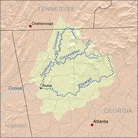
- Coosa RiverCoosa RiverThe Coosa River is a tributary of the Alabama River in the U.S. states of Alabama and Georgia. The river is about long altogether.The Coosa River is one of Alabama's most developed rivers...
- Chattooga RiverChattooga River (Alabama-Georgia)The Chattooga River runs through northwest Georgia and northeast Alabama in the United States. The river begins in Chattooga County, Georgia and flows into Weiss Lake on the Coosa River in Alabama. This river is one of two rivers named Chattooga in the state of Georgia. The other Chattooga...
- Etowah RiverEtowah RiverThe Etowah River is a waterway that rises northwest of Dahlonega, Georgia, north of Atlanta. Its name is the Cherokee version of the original Muskogee word Etalwa, which means a "trail crossing". On Matthew Carey's 1795 map the river was labeled "High Town River"...
- Little River
- Noonday CreekNoonday CreekNoonday Creek is a stream in Cobb and Cherokee counties in the U.S. state of Georgia. The stream begins near Kennesaw Mountain and ends at Lake Allatoona.-Geography:...
- Noonday Creek
- Little River
- Oostanaula RiverOostanaula RiverThe Oostanaula River is a principal tributary of the Coosa River, about long, in northwestern Georgia in the United States. Via the Coosa and Alabama rivers, it is part of the watershed of the Mobile River, which flows to the Gulf of Mexico. Its name is said to come from a Cherokee Indian term...
- Alan CreekAlan CreekAlan Creek is a small stream located in the community of New Town, Georgia, east of the city of Calhoun. It is a tributary of the Oostanaula River, part of the Coosa-Alabama-Mobile River watershed. It is near the New Echota Historic Site....
- Conasauga RiverConasauga RiverThe Conasauga River is a river that runs through southeast Tennessee and northwest Georgia. The Conasauga River is long and is home to 90 species of fish and 25 species of freshwater mussels...
- Jacks River
- Coosawattee RiverCoosawattee RiverThe Coosawattee River is a river located in the northwest part of the U.S. state of Georgia.The river begins at the confluence of the Ellijay River and Cartecay River in the city of Ellijay in Gilmer County. The river flows west through the foothills of the north Georgia mountains.In Murray...
- Cartecay RiverCartecay RiverThe Cartecay River is a river that runs through Ellijay, Georgia. It is the site of a class II whitewater run.The Cartecay and Ellijay rivers meet in Ellijay to form the Coosawattee River...
- Ellijay RiverEllijay RiverThe Ellijay River is a river in Georgia. It ends in the town of Ellijay at its confluence with the Cartecay River, forming the Coosawattee River.- References :*USGS Hydrologic Unit Map - State of Georgia...
- Cartecay River
- Alan Creek
- Chattooga River
- Tallapoosa RiverTallapoosa RiverThe Tallapoosa River runs from the southern end of the Appalachian Mountains in Georgia, in the United States, southward and westward into Alabama. It is formed by the confluence of McClendon Creek and Mud Creek in Paulding County, Georgia. Lake Martin at Alexander City, Alabama is a large and...
- Little Tallapoosa RiverLittle Tallapoosa RiverLittle Tallapoosa River is a river in Georgia and Alabama, in the United States. It rises in northern Carroll County, Georgia near the city of Villa Rica and flows southwest into Alabama, joining the Tallapoosa River in Randolph County near the head of R.L. Harris Reservoir.It is a water source...
- Little Tallapoosa River
- Coosa River
- Alabama River (AL)

- Mississippi River
- Ohio River
- Tennessee River (TN)
- Hiwassee RiverHiwassee RiverThe Hiwassee River has its headwaters on the north slope of Rocky Mountain in Towns County in northern Georgia and flows northward into North Carolina before turning westward into Tennessee, flowing into the Tennessee River a few miles west of State Route 58 in Meigs County, Tennessee...
- Toccoa River
- Nottely RiverNottely RiverThe Nottely River is a river in the United States. The river originates in the Blue Ridge Mountains in northern Georgia. The river flows for into the artificial Hiwassee Reservoir in North Carolina...
- Little Tennessee RiverLittle Tennessee RiverThe Little Tennessee River is a tributary of the Tennessee River, approximately 135 miles long, in the Appalachian Mountains in the southeastern United States.-Geography:...
- Hiwassee River
- Tennessee River (TN)
- Ohio River
Miscellaneous
- River StyxRiver Styx (Georgia)- References :**USGS Hydrologic Unit Map - State of Georgia...
- Georgia has two very small rivers named after the mythical StyxStyxIn Greek mythology the Styx is the river that forms the boundary between the underworld and the world of the living, as well as a goddess and a nymph that represents the river.Styx may also refer to:-Popular culture:...
. Both flow into swamps. One is in the Savannah River watershed, the other is in the St. Marys River watershed.
Alphabetically
- Alabaha RiverAlabaha RiverThe Alabaha River is a tributary of the Satilla River in the U.S. state of Georgia. It forms in northwestern Pierce County at the junction of Hurricane Creek and Little Hurricane Creek and flows southeast, past the county seat of Blackshear, and joins the Satilla River at the Pierce...
- Alan CreekAlan CreekAlan Creek is a small stream located in the community of New Town, Georgia, east of the city of Calhoun. It is a tributary of the Oostanaula River, part of the Coosa-Alabama-Mobile River watershed. It is near the New Echota Historic Site....
- Alapaha RiverAlapaha RiverThe Alapaha River is a river in southern Georgia and northern Florida in the United States. It is a tributary of the Suwannee River, which flows to the Gulf of Mexico.- Course :...
- Alapahoochee RiverAlapahoochee RiverThe Alapahoochee River is a tributary of the Alapaha River in Georgia and Florida in the United States. Via the Alapaha and Suwannee rivers, its waters flow to the Gulf of Mexico....
- Alcovy RiverAlcovy RiverThe Alcovy River is a tributary of the Ocmulgee River in north-central Georgia in the United States. Via the Ocmulgee River, it is part of the watershed of the Altamaha River, which flows to the Atlantic Ocean.-Course:...
- Alley Creek
- Alligator Creek
- Altamaha RiverAltamaha RiverThe Altamaha River is a major river of the American state of Georgia. It flows generally eastward for 137 miles from its origin at the confluence of the Oconee River and Ocmulgee River towards the Atlantic Ocean, where it empties into the ocean near Brunswick, Georgia. There are no dams...
- Apalachee RiverApalachee RiverThe Apalachee River is a tributary of the Oconee River in the U.S. state of Georgia. It rises north of Lawrenceville in eastern Gwinnett County and flows southeast to join the Oconee River in Lake Oconee west of Greensboro.- References :...
- Aucilla RiverAucilla RiverThe Aucilla River rises close to Thomasville, Georgia, USA, and passes through the Big Bend region of Florida, emptying into the Gulf of Mexico at Apalachee Bay. The river is long and has a drainage basin of . The Wacissa River is a tributary...
- Bear RiverBear River (Georgia)The Bear River is a tidal river in the U.S. state of Georgia. It forms the channel that separates Ossabaw Island from the Georgia mainland, connecting with the Ogeechee River at its north end and the Medway River at its south.- References :...
- Beech Creek
- Belfast RiverBelfast River (Georgia)The Belfast River is a tidal channel in Bryan County, Georgia, in the United States. It is a northern side channel of the Laurel View River. At its seaward end where it rejoins the Laurel View, the two rivers form the Medway River, which continues to the Atlantic Ocean through St. Catherines...
- Big Satilla CreekBig Satilla CreekBig Satilla Creek is a tributary of the Little Satilla River in the U.S. state of Georgia. It is part of the Satilla River watershed of southeastern Georgia.The creek rises in Hazlehurst in Jeff Davis County and flows south, then southeast...
- Big Satilla RiverBig Satilla River- References :*USGS Hydrologic Unit Map - State of Georgia...
- Black Creek
- Black RiverBlack River (Okefenokee Swamp)The Black River is a waterway that flows into the Okefenokee Swamp in the U.S. state of Georgia.- References :*USGS Hydrologic Unit Map - State of Georgia...
- Brier CreekBrier CreekBrier Creek is a tributary of the Savannah River in the U.S. state of Georgia. It rises in Warren County east of Camak and flows southeast to the Savannah River in Screven County, east of Sylvania.- References :...
- Brier River
- Broad RiverBroad River (Georgia)The Broad River is a tributary of the Savannah River in northeastern Georgia. The North Fork of the Broad River begins in the foothills of the Appalachian Mountains in Stephens County, then joins the Middle Fork west of Royston in Franklin County to form the main stem. The Broad River continues...
- Broro RiverBroro RiverThe Broro River is a tidal arm of the Sapelo River in McIntosh County, Georgia, in the United States.- References :*USGS Hydrologic Unit Map - State of Georgia...
- Brunswick RiverBrunswick River (Georgia)The Brunswick River is a tidal river in Georgia. It begins at the Sidney Lanier Bridge at Brunswick, Georgia, at the confluence of the Turtle River with the East River, and flows east to St. Simons Sound, the strait between Saint Simons Island to the north and Jekyll Island to the south.-...
- Buffalo RiverBuffalo River (Georgia)The Buffalo River is a tidal river northwest of Brunswick, Georgia. It is part of the Brunswick River network of tidal channels along the Atlantic coast of the U.S. state of Georgia.- References :*USGS Hydrologic Unit Map - State of Georgia...
- Bull Creek
- Bull RiverBull River (Georgia)The Bull River is an tidal river in the U.S. state of Georgia, running through Chatham County east of Savannah. At its north end it connects via St. Augustine Creek and the Wilmington River with the Savannah River. Its south end is at Wassaw Sound, leading to the Atlantic Ocean...
- Camp CreekCamp Creek (Fulton County, Georgia)Camp Creek is a tributary of the Chattahoochee River in Fulton County, Georgia. Rising in College Park, the creek flows west to join the Chattahoochee northeast of Campbellton....
- Caney Creek
- Canoochee RiverCanoochee RiverThe Canoochee River is a river in southeastern Georgia in the United States. It is a tributary of the Ogeechee River, which flows to the Atlantic Ocean.-Course:...
- Cartecay RiverCartecay RiverThe Cartecay River is a river that runs through Ellijay, Georgia. It is the site of a class II whitewater run.The Cartecay and Ellijay rivers meet in Ellijay to form the Coosawattee River...
- Chattahoochee RiverChattahoochee RiverThe Chattahoochee River flows through or along the borders of the U.S. states of Georgia, Alabama, and Florida. It is a tributary of the Apalachicola River, a relatively short river formed by the confluence of the Chattahoochee and Flint Rivers and emptying into Apalachicola Bay in the Gulf of...
- Chattooga RiverChattooga RiverThe Chattooga River is the main tributary of the Tugaloo River. Its headwaters are located southwest of Cashiers, North Carolina, and it stretches to where it has its confluence with the Tallulah River within Lake Tugalo, held back by the Tugalo Dam...
, the northeast boundary with South Carolina - Chattooga River (Alabama-Georgia)Chattooga River (Alabama-Georgia)The Chattooga River runs through northwest Georgia and northeast Alabama in the United States. The river begins in Chattooga County, Georgia and flows into Weiss Lake on the Coosa River in Alabama. This river is one of two rivers named Chattooga in the state of Georgia. The other Chattooga...
, in northwest Georgia - Chestatee RiverChestatee RiverThe Chestatee River is a river in the Appalachian Mountains of northern Georgia, USA. It begins at the confluence of Dicks Creek and Frogtown Creek The Chestatee River (variant spellings Chestatie, Chestetee, Chostatee, Chosteta, none in modern use) is a river in the Appalachian Mountains of...
- Coleman RiverColeman RiverColeman River is a stream that is located in the Blue Ridge Mountains, mostly within Rabun County, Georgia. It is one of the main tributaries of the Tallulah River. The headwaters of Coleman River are located in Clay County, North Carolina, and the river travels a short distance before crossing...
- Conasauga RiverConasauga RiverThe Conasauga River is a river that runs through southeast Tennessee and northwest Georgia. The Conasauga River is long and is home to 90 species of fish and 25 species of freshwater mussels...
- Coosa RiverCoosa RiverThe Coosa River is a tributary of the Alabama River in the U.S. states of Alabama and Georgia. The river is about long altogether.The Coosa River is one of Alabama's most developed rivers...
- Coosawattee RiverCoosawattee RiverThe Coosawattee River is a river located in the northwest part of the U.S. state of Georgia.The river begins at the confluence of the Ellijay River and Cartecay River in the city of Ellijay in Gilmer County. The river flows west through the foothills of the north Georgia mountains.In Murray...
- Crescent RiverCrescent River (Georgia)The Crescent River is a tidal river in McIntosh County, Georgia, in the United States. It forms in salt marshes east of the community of Bellville Point and flows southeast, ending at a river junction where the Mud River flows northeast into Sapelo Sound and Old Teakettle Creek flows south to...
- Crooked Creek
- Crooked RiverCrooked River (Georgia)The Crooked River is a river in Camden County in the U.S. state of Georgia. Primarily tidal, it is an inlet of Cumberland Sound.It rises in freshwater wetlands northwest of Kingsland and flows east into saltmarsh. Grover Island lies to the north of the main channel, and Crooked River State Park...
- Cumberland RiverCumberland River (Georgia)The Cumberland River is a tidal channel in the U.S. state of Georgia. It forms the northern half of the waterway that separates Cumberland Island from the Georgia mainland, connecting with Cumberland Sound to the south and St. Andrew Sound and the Satilla River to the north...
- Darien RiverDarien River (Georgia)The Darien River is a tidal river in the U.S. state of Georgia, in the vicinity of the city of Darien. It is part of the large complex of salt marshes surrounding the mouth of the Altamaha River.- References :...
- Deep Creek
- Dog RiverDog River (Georgia)The Dog River is a river in Georgia. The river rises south of Villa Rica in Carroll County, flows west into Douglas County, then turns southwestward into Dog River Reservoir. The reservoir, completed in 1992, impounded of water before the dam and water level were increased in 2009. The reservoir...
- Duplin RiverDuplin RiverThe Duplin River is an tidal river in McIntosh County, Georgia, in the United States. It flows from north to south along the western edge of Sapelo Island into Doboy Sound, an arm of the Atlantic Ocean.- References :...
- Ebenezer CreekEbenezer CreekEbenezer Creek is a location in Georgia where hundreds of freed black slaves were abandoned during General Sherman's march during the American Civil War. After the army had crossed over on pontoons the commander in charge of the crossing, BG Jefferson C. Davis, cut them loose, leaving the escaped...
- Ellijay RiverEllijay RiverThe Ellijay River is a river in Georgia. It ends in the town of Ellijay at its confluence with the Cartecay River, forming the Coosawattee River.- References :*USGS Hydrologic Unit Map - State of Georgia...
- Etowah RiverEtowah RiverThe Etowah River is a waterway that rises northwest of Dahlonega, Georgia, north of Atlanta. Its name is the Cherokee version of the original Muskogee word Etalwa, which means a "trail crossing". On Matthew Carey's 1795 map the river was labeled "High Town River"...
- Flat Shoal Creek
- Flint RiverFlint River (Georgia)The Flint River is a river in the U.S. state of Georgia. The river drains of western Georgia, flowing south from the upper Piedmont region south of Atlanta to the wetlands of the Gulf Coastal Plain in the southwestern corner of the state. Along with the Apalachicola and the Chattahoochee rivers,...
- Foe Killer CreekFoe Killer Creek- Name :The name Foe Killer Creek is most likely a corruption of Four Killer, a Cherokee who lived at the head of the creek....
- Frederica RiverFrederica RiverThe Frederica River is an tidal river in Glynn County, Georgia. It forms the western boundary of Saint Simons Island of the Georgia Sea Islands. Fort Frederica National Monument is located on the eastern bank of the river on Saint Simons Island....
- Gum Swamp Creek
- Halfmoon RiverHalfmoon RiverThe Halfmoon River is a tidal river in the U.S. state of Georgia. It flows through saltmarshes connected to Wilmington Island in Chatham County, ending at Wassaw Sound, an arm of the Atlantic Ocean.- References :...
- Hampton RiverHampton River (Georgia)The Hampton River is a tidal river in Glynn County, Georgia. It forms the channel between Saint Simons Island and Little Saint Simons Island on the Atlantic coast.- References :*USGS Hydrologic Unit Map - State of Georgia...
- Hannahatchee Creek
- Hazel Creek
- Herb RiverHerb RiverThe Herb River is an tidal river in the U.S. state of Georgia. It is located in Chatham County, near the southeastern edge of Savannah. It connects with the Wilmington River to the north and the Moon River to the south, and it separates the mainland on the west from Isle of Hope and Dutch Island...
- Hiwassee RiverHiwassee RiverThe Hiwassee River has its headwaters on the north slope of Rocky Mountain in Towns County in northern Georgia and flows northward into North Carolina before turning westward into Tennessee, flowing into the Tennessee River a few miles west of State Route 58 in Meigs County, Tennessee...
- Hog Wallow Creek
- Hudson River (Georgia)Hudson River (Georgia)The Hudson River is a tributary of the Broad River in the U.S. state of Georgia. Via the Broad River, it is part of the Savannah River watershed....
- Ichawaynochaway CreekIchawaynochaway CreekIchawaynochaway Creek is a creek in southwest Georgia. It rises near Weston in two forks and flows south-southeasterly for , joining the Flint River southwest of Newton....
- Jacks River
- Jerico RiverJerico RiverThe Jerico River is a river on the Atlantic coastal plain in the U.S. state of Georgia. It serves as the boundary between Bryan and Liberty counties for its entire length....
- Johns Creek
- Kettle CreekKettle Creek (Georgia)Kettle Creek is a tributary of the Little River in Wilkes County, Georgia, in the United States. It is part of the Savannah River watershed.The Battle of Kettle Creek, an important battle in the American Revolutionary War, took place at this site....
- Kinchafoonee CreekKinchafoonee CreekKinchafoonee Creek is a creek in southwest Georgia. It originates near Buena Vista and flows southeasterly for to the Flint River near Albany, Georgia....
- Knoxboro CreekKnoxboro CreekThe Knoxboro Creek is a tributary of the Savannah River. It is located at the boundary between Effingham and Chatham counties in the Greater Savannah Area ....
- Laurel View RiverLaurel View RiverThe Laurel View River is a tidal river in the U.S. state of Georgia. It is fed by the Jerico River, which splits into the Laurel View and Belfast rivers, and ends where the Belfast River rejoins it, forming the Medway River, which continues to the Atlantic Ocean...
- Law Creek
- Liberty Creek
- Lick Log Creek
- Little Hazel Creek
- Little Ochlockonee RiverLittle Ochlockonee RiverThere are two streams named the Little Ochlockonee River in southern Georgia in the United States. Both are tributaries of the Ochlockonee River....
- Little Ocmulgee RiverLittle Ocmulgee RiverThe Little Ocmulgee River is a tributary of the Ocmulgee River in the U.S. state of Georgia.- References :*USGS Hydrologic Unit Map - State of Georgia...
- Little Ogeechee River (Chatham County)Little Ogeechee River (Chatham County)The Little Ogeechee River in Chatham County is one of two rivers by that name in the U.S. state of Georgia. Rising in southern Effingham County, the Little Ogeechee flows to the southeast and enters Chatham County, where it becomes tidal in the vicinity of its crossing by U.S. Route 17...
- Little Ogeechee River (Hancock County)Little Ogeechee River (Hancock County)The Little Ogeechee River in Hancock County is one of two rivers with that name in the U.S. state of Georgia. It rises in Hancock County northeast of Sparta and flows southeast into Washington County, passing through Hamburgh State Park and entering the Ogeechee River southwest of Mitchell. The...
- Little Ohoopee River
- Little River (Columbia County, Georgia)
- Little River (Etowah River)
- Little River (Oconee River)Little River (Oconee River)The Little River is a tributary of the Oconee River in the U.S. state of Georgia. It rises in Walton County near the city of Social Circle and flows southeast to join the Oconee River in Lake Sinclair.- References :...
- Little River (Savannah River)Little River (Savannah River)The Little River is a tributary of the Savannah River in the U.S. state of Georgia. It is formed by the juncture of its North and South forks north of Crawfordville, and it flows generally east to Clark Hill Lake, where it joins the Savannah River north of the dam.-References:*USGS Hydrologic...
- Little River (Withlacoochee River)Little River (Withlacoochee River)The Little River is a tributary of the Withlacoochee River in the U.S. state of Georgia. Via the Withlacoochee and the Suwannee River its waters flow to the Gulf of Mexico.The Little River rises in northwestern Turner County, Georgia, northwest of Ashburn...
- Little Satilla CreekLittle Satilla CreekThe Little Satilla Creek is a tributary of the Little Satilla River in the U.S. state of Georgia. It is part of the Satilla River watershed in southeastern Georgia....
- Little Satilla RiverLittle Satilla River (Atlantic Ocean)The Little Satilla River is a tidal river that forms the boundary between Glynn and Camden counties in the U.S. state of Georgia. It is a separate river from the Little Satilla River, to the northwest, that is a freshwater tributary of the Satilla River....
- Little Tallapoosa RiverLittle Tallapoosa RiverLittle Tallapoosa River is a river in Georgia and Alabama, in the United States. It rises in northern Carroll County, Georgia near the city of Villa Rica and flows southwest into Alabama, joining the Tallapoosa River in Randolph County near the head of R.L. Harris Reservoir.It is a water source...
- Little Tennessee RiverLittle Tennessee RiverThe Little Tennessee River is a tributary of the Tennessee River, approximately 135 miles long, in the Appalachian Mountains in the southeastern United States.-Geography:...
- Mackay RiverMackay RiverThe Mackay River is a tidal river in Glynn County, Georgia. It flows between Saint Simons Island to the east and the mainland, including the city of Brunswick, to the west, and connects to Buttermilk Sound at its north end and St. Simons Sound and the Brunswick River at its south end. It runs...
- Medway RiverMedway River (Georgia)The Medway River is an tidal river in the U.S. state of Georgia. It is formed by the confluence of the Laurel View River with the smaller Belfast and Tivoli rivers, all three of which are tidal. It empties into St. Catherines Sound, an arm of the Atlantic Ocean...
- Middle Oconee River
- Mountain Oak Creek
- Muckalee CreekMuckalee creekMuckalee Creek is a creek in southwest Georgia . It originates southeast of Buena Vista and flows south-southeast for and into Kinchafoonee Creek north of Albany, just upstream of that creek's confluence with the Flint River.-References:*...
- Mud RiverMud River (Georgia)The Mud River is a tidal arm of the Sapelo River in McIntosh County, Georgia, in the United States. It forms the northern part of the channel separating Sapelo Island from the mainland.- References :*USGS Hydrologic Unit Map - State of Georgia...
- Mulberry Creek
- Mulberry RiverMulberry River (Georgia)The Mulberry River is a tributary of the Middle Oconee River in the U.S. state of Georgia. It rises in southeastern Hall County and flows southeast, forming the boundary between Jackson and Barrow counties, to join the Middle Oconee south of Jefferson....
- Nancy CreekNancy Creek (Atlanta)Nancy Creek is a stream in northern Atlanta, Georgia, United States. It begins in far northern DeKalb County, just north of Chamblee, and flows southwestward into Fulton County, through the far southeast corner of Sandy Springs, then through the Buckhead area of Atlanta. It empties into...
- New River (Chattahoochee River)New River (Chattahoochee River)The New River is a tributary of the Chattahoochee River in Coweta and Heard counties in the U.S. state of Georgia. Rising south of the city of Newnan, the New River flows generally southwest, reaching the Chattahoochee at West Point Lake approximately west of Hogansville.- References :*USGS...
- New River (Withlacoochee River)New River (Withlacoochee River)The New River is a tributary of the Withlacoochee River in the U.S. state of Georgia. Via the Withlacoochee and Suwannee rivers, its waters flow to the Gulf of Mexico....
- Noonday CreekNoonday CreekNoonday Creek is a stream in Cobb and Cherokee counties in the U.S. state of Georgia. The stream begins near Kennesaw Mountain and ends at Lake Allatoona.-Geography:...
- North Newport RiverNorth Newport RiverThe North Newport River is a tidal river in Liberty County in the U.S. state of Georgia. It rises just west of Interstate 95, south of Richmond Hill, and flows generally east-southeast to its mouth at the Medway River and St. Catherines Sound on the Atlantic Ocean....
- North Oconee River
- North River (Darien River)North River (Darien River)The North River is a tidal river channel, approximately long, in coastal Georgia, the United States. It is a longer and narrower alternative channel to the tidal Darien River and ultimately is part of the Altamaha River system in the marshes between Darien, Georgia and the Atlantic Ocean....
- North River (St. Marys River)North River (St. Marys River)The North River is a tidal river in southeastern Georgia, the United States. It is a tributary of the St. Marys River, joining it just east of the city of St. Marys....
- Noses CreekNoses CreekNoses Creek is a stream in Cobb County, Georgia, USA. It is a significant tributary of the much larger Sweetwater Creek, in turn part of the Chattahoochee River basin. On topographic maps, it begins between Kennesaw and Marietta and flows generally south-southwesterly to just northwest of Austell...
- Nottely RiverNottely RiverThe Nottely River is a river in the United States. The river originates in the Blue Ridge Mountains in northern Georgia. The river flows for into the artificial Hiwassee Reservoir in North Carolina...
- Ochlockonee RiverOchlockonee RiverThe Ochlockonee River is a fast running river originating in Georgia and flowing for before terminating in Florida.- Background :The Ochlockonee originates south of the town of Sylvester in Worth County in southwest Georgia emptying into Ochlockonee Bay, then into Apalachee Bay, in Florida...
- Ocmulgee RiverOcmulgee RiverThe Ocmulgee River is a tributary of the Altamaha River, approximately 255 mi long, in the U.S. state of Georgia...
- Oconee RiverOconee RiverThe Oconee River is a river which has its origin in Hall County, Georgia, and terminates where it joins the Ocmulgee River to form the Altamaha River near Lumber City at the borders of Montgomery County, Wheeler County, and Jeff Davis County. South of Athens, two forks, known as the North Oconee...
- Odingsell RiverOdingsell RiverThe Odingsell River is a tidal river in the U.S. state of Georgia. It flows into Ossabaw Sound just north of the mouth of the Ogeechee River. It passes through salt marshes lying between Skidaway Island to the west, Wassaw Island to the north and east, and Little Wassaw Island to the south.-...
- Ogeechee RiverOgeechee RiverOgeechee River is a river in the U.S. state of Georgia. It heads at the confluence of its North and South Forks, about south-southwest of Crawfordville and flowing generally southeast to Ossabaw Sound about south of Savannah. Its largest tributary is the Canoochee River...
- Ohoopee RiverOhoopee RiverThe Ohoopee River is a river in east-central Georgia in the United States. It is a tributary of the Altamaha River, which flows to the Atlantic Ocean.-Course:...
- Okapilco CreekOkapilco CreekOkapilco Creek is a tributary of the Withlacoochee River in the U.S. state of Georgia. Via the Withlacoochee and the Suwannee River, the waters of Okapilco Creek flow to the Gulf of Mexico....
- Oostanaula RiverOostanaula RiverThe Oostanaula River is a principal tributary of the Coosa River, about long, in northwestern Georgia in the United States. Via the Coosa and Alabama rivers, it is part of the watershed of the Mobile River, which flows to the Gulf of Mexico. Its name is said to come from a Cherokee Indian term...
- Pataula Creek
- Peachtree CreekPeachtree CreekPeachtree Creek is a major stream in Atlanta. It flows for almost due west into the Chattahoochee River just south of Vinings. Like other "Peachtree" names in the area, the name is most likely a corruption of "pitch tree", from the area's many pines and their sticky sap.Peachtree Creek is an...
- River StyxRiver Styx (Georgia)- References :**USGS Hydrologic Unit Map - State of Georgia...
- Rocky Comfort CreekRocky Comfort CreekRocky Comfort Creek is a tributary of the Ogeechee River in the U.S. state of Georgia. Rising in Warren County northwest of Warrenton, it flows southeast, entering Glascock County and passing the town of Gibson, then continuing south into Jefferson County, where it reaches the Ogeechee River at...
- St. Marys River
- Sapelo RiverSapelo RiverThe Sapelo River is a primarily tidal river in McIntosh County in the U.S. state of Georgia. It forms between Interstate 95 and U.S. Route 17 near the community of Eulonia and winds generally east through salt marshes into Sapelo Sound, an arm of the Atlantic Ocean that separates St...
- Satilla RiverSatilla RiverThe Satilla River rises in Ben Hill County, Georgia, near the town of Fitzgerald, and flows in a mostly easterly direction to the Atlantic Ocean. Along its approximately course are the cities of Waycross, Waynesville, and Woodbine. The Satilla drains almost of land, all of it in the coastal...
- Savannah RiverSavannah RiverThe Savannah River is a major river in the southeastern United States, forming most of the border between the states of South Carolina and Georgia. Two tributaries of the Savannah, the Tugaloo River and the Chattooga River, form the northernmost part of the border...
- Sawhatchee Creek
- Sewell Mill CreekSewell mill creekSewell Mill Creek is a tributary of Sope Creek in Marietta, Georgia, United States. Via Sope Creek and the Chattahoochee River, it is part of the Apalachicola River basin, draining to the Gulf of Mexico....
- Shad RiverShad River (Georgia)The Shad River is a tidal river in the U.S. state of Georgia. It is a tributary of the Bull River and flows through salt marshes connected to Wilmington Island in Chatham County.- References :*USGS Hydrologic Unit Map - State of Georgia...
- Shoal Creek
- Sixteen Mile River
- Skidaway RiverSkidaway RiverThe Skidaway River is an tidal river in the U.S. state of Georgia. It is located in Chatham County southeast of Savannah. Its north end is at the Wilmington River, and it flows southwest from there through Skidaway Narrows to end at the Burnside River, which connects via the Vernon and Little...
- Sope CreekSope CreekSope Creek is an stream located in Cobb County, Georgia, United States. It is a significant tributary of the Chattahoochee River, and under high water levels it can be used for extreme whitewater kayaking...
- Soquee River
- South Newport RiverSouth Newport RiverThe South Newport River is a river on the Atlantic coastal plain in the U.S. state of Georgia. It rises in Long County south of Walthourville and flows east-southeast, becoming the boundary between Liberty and McIntosh counties. It flows into Sapelo Sound, an arm of the Atlantic Ocean, south of St...
- South River (Darien River)South River (Darien River)The South River is a tidal channel in McIntosh County, Georgia, in the United States. It connects the Darien River to its west with Doboy Sound, an arm of the Atlantic Ocean, to its east. It flows through an extensive saltmarsh complex, with Queens Island to the north and Wolf Island to the...
- South River (Ocmulgee River)South River (Ocmulgee River)The South River is a tributary of the Ocmulgee River in the U.S. state of Georgia. It originates in the city of East Point in Fulton County and eventually flows into Lake Jackson, joining the Yellow River and the Alcovy River to form the Ocmulgee....
- Spring CreekSpring Creek (Flint River)Spring Creek is a tributary of the Flint River in southwest Georgia in the United States.Rising in the northeastern corner of Clay County, north of Bluffton, the creek flows south to join the Flint River in Lake Seminole, approximately upstream of that river's confluence with the Chattahoochee...
- Suwannee RiverSuwannee RiverThe Suwannee River is a major river of southern Georgia and northern Florida in the United States. It is a wild blackwater river, about long. The Suwannee River is the site of the prehistoric Suwannee Straits which separated peninsular Florida from the panhandle.-Geography:The river rises in the...
- Suwannoochee CreekSuwannoochee CreekSuwannoochee Creek is a tributary of the Suwannee River in the U.S. state of Georgia. It rises in western Clinch County, Georgia, about west of Homerville, and flows southeast to join the Suwannee near Fargo. For the lower half of its course it forms the boundary between Clinch and Echols...
- Sweetwater Creek
- Swift Creek
- Tallapoosa RiverTallapoosa RiverThe Tallapoosa River runs from the southern end of the Appalachian Mountains in Georgia, in the United States, southward and westward into Alabama. It is formed by the confluence of McClendon Creek and Mud Creek in Paulding County, Georgia. Lake Martin at Alexander City, Alabama is a large and...
- Tallulah RiverTallulah RiverThe Tallulah River is a river in Georgia and North Carolina. It begins in Clay County, North Carolina, near Standing Indian Mountain in the Southern Nantahala Wilderness and flows south into Georgia, crossing the state line into Towns County. The river then travels through Rabun County and ends in...
- Tesnatee Creek
- Tivoli RiverTivoli RiverThe Tivoli River is an primarily tidal river in Bryan County, Georgia, in the United States. It flows into the Belfast River, just north of that river's terminus at the Medway River, an arm of the Atlantic Ocean.- References :...
- Tobesofkee CreekTobesofkee CreekTobesofkee Creek is a river in Georgia. It originates near Barnesville and flows roughly southeast across Lamar, Monroe, and Bibb counties to join the Ocmulgee River south of the city of Macon...
- Toccoa River
- Towaliga RiverTowaliga RiverThe Towaliga River is a tributary of the Ocmulgee River in central Georgia. The name, Towaliga, is of Creek origin and translates to "Roasted Scalp." The Creek Indians of the area were known to scalp their enemies and place their scalps on the large rocks by the river...
- Tugaloo RiverTugaloo RiverThe Tugaloo River is a river bordering the U.S. states of Georgia and South Carolina. It is fed by the Tallulah River and the Chattooga River, which each form an arm of Lake Tugalo, on the edge of Georgia's Tallulah Gorge State Park. The Tugaloo then flows out of the lake via Tugaloo Dam,...
- Turtle RiverTurtle River (Georgia)The Turtle River is a tidal river in the vicinity of Brunswick, Georgia. It is the main tributary of the Brunswick River.- References :*USGS Hydrologic Unit Map - State of Georgia...
- Upatoi CreekUpatoi CreekUpatoi Creek is a river in western Georgia, just outside of Columbus. It runs from Upatoi, through South Columbus, and to the Chattahoochee River.- References :*USGS Hydrologic Unit Map - State of Georgia...
- Vernon RiverVernon River (Georgia)The Vernon River is a primarily tidal river in the U.S. state of Georgia. Located in Chatham County, it rises south of Hunter Army Airfield in Savannah and flows south into tidal marshes, where it joins the Little Ogeechee River southwest of Skidaway Island....
- Vickery CreekVickery CreekBig Creek is a stream in Forsyth and Fulton counties in Georgia. The creek mouth into the Chattahoochee River is located at the southern border of Roswell where State Route 9 crosses the river...
, or Big Creek - Willacoochee RiverWillacoochee RiverThe Willacoochee River is a tributary of the Alapaha River in the U.S. state of Georgia. Via the Alapaha and Suwannee rivers, its waters flow to the Gulf of Mexico....
- Willeo CreekWilleo CreekWilleo Creek is a stream in the U.S. state of Georgia, and is located in the north-northwestern part of metro Atlanta. It is a significant tributary of the Chattahoochee River, into which it flows at Bull Sluice Lake, just upstream from Morgan Falls Dam and downstream from the Chattahoochee...
- Williamson Swamp CreekWilliamson Swamp CreekThe Williamson Swamp Creek is a tributary of the Ogeechee River in the U.S. state of Georgia. Rising in northwestern Washington County north of Sandersville, it flows southeast past Davisboro and enters Jefferson County, ending at the Ogeechee River southeast of Wadley.- References :*USGS...
- Wilmington RiverWilmington River (Georgia)The Wilmington River is a tidal river in the U.S. state of Georgia. It flows through Chatham County along the east side of the city of Savannah. At its north end, it connects with the Savannah River, then travels southwest past Savannah, then turns southeast and ends in Wassaw Sound, an arm of...
- Withlacoochee River
- Yellow RiverYellow River (Georgia)The Yellow River is a tributary of the Ocmulgee River in the U.S. state Georgia.The river rises north of Lawrenceville in Gwinnett County and flows south through the outer eastern suburbs of Atlanta, passing through the easternmost corner of DeKalb County before entering Rockdale County...
- Yellowjacket Creek