

Lincoln County, Wisconsin
Encyclopedia
Lincoln County is a county
located in the U.S. state
of Wisconsin
. As of 2000, the population was 29,641. Its county seat
is Merrill
.
, the county has a total area of 907 square miles (2,349.1 km²), of which 883 square miles (2,287 km²) is land and 24 square miles (62.2 km²) (2.62%) is water.
As of the census
of 2000, there were 29,641 people, 11,721 households, and 8,228 families residing in the county. The population density
was 34 people per square mile (13/km²). There were 14,681 housing units at an average density of 17 per square mile (6/km²). The racial makeup of the county was 97.76% White
, 0.41% Black
or African American
, 0.44% Native American
, 0.39% Asian
, 0.03% Pacific Islander
, 0.29% from other races
, and 0.68% from two or more races. 0.82% of the population were Hispanic
or Latino
of any race. 55.9% were of German, 5.7% Polish and 5.3% Norwegian ancestry according to Census 2000. 96.9% spoke English
, 1.3% German
and 1.2% Spanish
as their first language.
There were 11,721 households out of which 31.40% had children under the age of 18 living with them, 58.40% were married couples
living together, 8.10% had a female householder with no husband present, and 29.80% were non-families. 25.50% of all households were made up of individuals and 12.10% had someone living alone who was 65 years of age or older. The average household size was 2.46 and the average family size was 2.94.
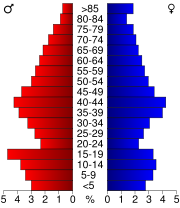
In the county, the population was spread out with 25.40% under the age of 18, 6.90% from 18 to 24, 28.00% from 25 to 44, 23.30% from 45 to 64, and 16.40% who were 65 years of age or older. The median age was 39 years. For every 100 females there were 99.90 males. For every 100 females age 18 and over, there were 95.10 males.
This digital collection contains historic images and texts that document central Wisconsin schools and libraries in Marathon and Lincoln Counties. Text-based materials include: Marchetti, Louis. History of the Public Library Building and Names of Donors, 1909, a record of the proceedings, leading up, and culminating in the erection and completion of the Library Building of the city of Wausau, with names of Donors attached thereto. Compiled and presented to the Library by Louis Marchetti, President of the Library Board from 1904 to 1908.
County (United States)
In the United States, a county is a geographic subdivision of a state , usually assigned some governmental authority. The term "county" is used in 48 of the 50 states; Louisiana is divided into parishes and Alaska into boroughs. Parishes and boroughs are called "county-equivalents" by the U.S...
located in the U.S. state
U.S. state
A U.S. state is any one of the 50 federated states of the United States of America that share sovereignty with the federal government. Because of this shared sovereignty, an American is a citizen both of the federal entity and of his or her state of domicile. Four states use the official title of...
of Wisconsin
Wisconsin
Wisconsin is a U.S. state located in the north-central United States and is part of the Midwest. It is bordered by Minnesota to the west, Iowa to the southwest, Illinois to the south, Lake Michigan to the east, Michigan to the northeast, and Lake Superior to the north. Wisconsin's capital is...
. As of 2000, the population was 29,641. Its county seat
County seat
A county seat is an administrative center, or seat of government, for a county or civil parish. The term is primarily used in the United States....
is Merrill
Merrill, Wisconsin
Merrill is a city in Lincoln County, Wisconsin, United States. The population was 10,728 at the 2010 census. The city is located to the south of and adjacent to the Town of Merrill....
.
Geography
According to the U.S. Census BureauUnited States Census Bureau
The United States Census Bureau is the government agency that is responsible for the United States Census. It also gathers other national demographic and economic data...
, the county has a total area of 907 square miles (2,349.1 km²), of which 883 square miles (2,287 km²) is land and 24 square miles (62.2 km²) (2.62%) is water.
Adjacent counties
- Oneida CountyOneida County, WisconsinOneida County is a county in the U.S. state of Wisconsin. As of 2000, the population was 36,776. Its county seat is Rhinelander.-Geography:According to the U.S. Census Bureau, the county has a total area of 1,236 square miles , of which 1,124 square miles is land and 111 square...
- north - Langlade CountyLanglade County, WisconsinLanglade County is a county located in the U.S. state of Wisconsin. As of 2000, the population was 20,740. Its county seat is Antigo.-Geography:According to the U.S. Census Bureau, the county has a total area of , of which is land and is water...
- east - Marathon CountyMarathon County, WisconsinMarathon County is a county located in the U.S. state of Wisconsin. It is part of the Wausau, WI, Metropolitan Statistical Area. As of 2010, the population was 134,063. Its county seat is Wausau.-Geography:...
- south - Taylor CountyTaylor County, WisconsinTaylor County is a county in the U.S. state of Wisconsin. As of 2010, the population was 20,689. Its county seat is Medford.-History:The earliest recorded event in Taylor county probably occurred in 1661, when Wisconsin was part of New France...
- west - Price CountyPrice County, WisconsinPrice County is a county in the U.S. state of Wisconsin. As of 2000, the population was 15,822. Its county seat is Phillips.-Geography:According to the U.S. Census Bureau, the county has a total area of , of which is land and is water...
- northwest
Major highways
|
 Highway 64 (Wisconsin) Highway 64 (Wisconsin)Highway 64 (Wisconsin) State Trunk Highway 64 is a Wisconsin state highway running east–west across central Wisconsin. It is in length. The western end of Highway 64 is located at the Minnesota state line on the Stillwater Bridge in Stillwater, Minnesota. The eastern end is located at U.S...  Highway 86 (Wisconsin) Highway 86 (Wisconsin)Highway 86 (Wisconsin) State Trunk Highway 86 is a state highway in the U.S. state of Wisconsin. It runs east–west in north central Wisconsin from Ogema to Tomahawk....  Highway 107 (Wisconsin) Highway 107 (Wisconsin)Highway 107 (Wisconsin) State Trunk Highway 107 is a state highway in the U.S. state of Wisconsin. It runs in a north–south in central Wisconsin from west of Mosinee to south of Tomahawk.... |
 U.S. Highway 8
 U.S. Highway 51
Demographics
As of the census
Census
A census is the procedure of systematically acquiring and recording information about the members of a given population. It is a regularly occurring and official count of a particular population. The term is used mostly in connection with national population and housing censuses; other common...
of 2000, there were 29,641 people, 11,721 households, and 8,228 families residing in the county. The population density
Population density
Population density is a measurement of population per unit area or unit volume. It is frequently applied to living organisms, and particularly to humans...
was 34 people per square mile (13/km²). There were 14,681 housing units at an average density of 17 per square mile (6/km²). The racial makeup of the county was 97.76% White
Race (United States Census)
Race and ethnicity in the United States Census, as defined by the Federal Office of Management and Budget and the United States Census Bureau, are self-identification data items in which residents choose the race or races with which they most closely identify, and indicate whether or not they are...
, 0.41% Black
Race (United States Census)
Race and ethnicity in the United States Census, as defined by the Federal Office of Management and Budget and the United States Census Bureau, are self-identification data items in which residents choose the race or races with which they most closely identify, and indicate whether or not they are...
or African American
Race (United States Census)
Race and ethnicity in the United States Census, as defined by the Federal Office of Management and Budget and the United States Census Bureau, are self-identification data items in which residents choose the race or races with which they most closely identify, and indicate whether or not they are...
, 0.44% Native American
Race (United States Census)
Race and ethnicity in the United States Census, as defined by the Federal Office of Management and Budget and the United States Census Bureau, are self-identification data items in which residents choose the race or races with which they most closely identify, and indicate whether or not they are...
, 0.39% Asian
Race (United States Census)
Race and ethnicity in the United States Census, as defined by the Federal Office of Management and Budget and the United States Census Bureau, are self-identification data items in which residents choose the race or races with which they most closely identify, and indicate whether or not they are...
, 0.03% Pacific Islander
Race (United States Census)
Race and ethnicity in the United States Census, as defined by the Federal Office of Management and Budget and the United States Census Bureau, are self-identification data items in which residents choose the race or races with which they most closely identify, and indicate whether or not they are...
, 0.29% from other races
Race (United States Census)
Race and ethnicity in the United States Census, as defined by the Federal Office of Management and Budget and the United States Census Bureau, are self-identification data items in which residents choose the race or races with which they most closely identify, and indicate whether or not they are...
, and 0.68% from two or more races. 0.82% of the population were Hispanic
Race (United States Census)
Race and ethnicity in the United States Census, as defined by the Federal Office of Management and Budget and the United States Census Bureau, are self-identification data items in which residents choose the race or races with which they most closely identify, and indicate whether or not they are...
or Latino
Race (United States Census)
Race and ethnicity in the United States Census, as defined by the Federal Office of Management and Budget and the United States Census Bureau, are self-identification data items in which residents choose the race or races with which they most closely identify, and indicate whether or not they are...
of any race. 55.9% were of German, 5.7% Polish and 5.3% Norwegian ancestry according to Census 2000. 96.9% spoke English
English language
English is a West Germanic language that arose in the Anglo-Saxon kingdoms of England and spread into what was to become south-east Scotland under the influence of the Anglian medieval kingdom of Northumbria...
, 1.3% German
German language
German is a West Germanic language, related to and classified alongside English and Dutch. With an estimated 90 – 98 million native speakers, German is one of the world's major languages and is the most widely-spoken first language in the European Union....
and 1.2% Spanish
Spanish language
Spanish , also known as Castilian , is a Romance language in the Ibero-Romance group that evolved from several languages and dialects in central-northern Iberia around the 9th century and gradually spread with the expansion of the Kingdom of Castile into central and southern Iberia during the...
as their first language.
There were 11,721 households out of which 31.40% had children under the age of 18 living with them, 58.40% were married couples
Marriage
Marriage is a social union or legal contract between people that creates kinship. It is an institution in which interpersonal relationships, usually intimate and sexual, are acknowledged in a variety of ways, depending on the culture or subculture in which it is found...
living together, 8.10% had a female householder with no husband present, and 29.80% were non-families. 25.50% of all households were made up of individuals and 12.10% had someone living alone who was 65 years of age or older. The average household size was 2.46 and the average family size was 2.94.
In the county, the population was spread out with 25.40% under the age of 18, 6.90% from 18 to 24, 28.00% from 25 to 44, 23.30% from 45 to 64, and 16.40% who were 65 years of age or older. The median age was 39 years. For every 100 females there were 99.90 males. For every 100 females age 18 and over, there were 95.10 males.
Towns
- BirchBirch, WisconsinBirch is a town in Lincoln County, Wisconsin, United States. As of the 2000 census, the town had a total population of 801. The town of Irma is located in the town.-Geography:...
- BradleyBradley, WisconsinBradley is a town in Lincoln County, Wisconsin, United States. The population was 2,573 at the 2000 census. The unincorporated communities of Bradley and Heafford Junction are located in the town.-Geography:...
- CorningCorning, WisconsinCorning is a town in Lincoln County, Wisconsin, United States. The population was 826 at the 2000 census.-Geography:According to the United States Census Bureau, the town has a total area of 146.6 square miles , of which, 146.5 square miles of it is land and 0.1 square miles of it ...
- HardingHarding, WisconsinHarding is a town in Lincoln County, Wisconsin, United States. The population was 334 at the 2000 census.-Geography:According to the United States Census Bureau, the town has a total area of 72.8 square miles , of which, 72.1 square miles of it is land and 0.7 square miles of it ...
- HarrisonHarrison, Lincoln County, WisconsinHarrison is a town in Lincoln County, Wisconsin, United States. The population was 793 at the 2000 census. The unincorporated communities of Bundy, Harrison, and Jeffris are located in the town.-Geography:...
- KingKing, Lincoln County, WisconsinKing is a town in Lincoln County, Wisconsin, United States. The population was 842 at the 2000 census.-Geography:According to the United States Census Bureau, the town has a total area of 36.9 square miles , of which, 33.9 square miles of it is land and 3.0 square miles of it is...
- Merrill (town)Merrill (town), WisconsinMerrill is a town in Lincoln County, Wisconsin, United States. The population was 2,979 at the 2000 census. The City of Merrill is located to the south of and adjacent to the town...
- Pine RiverPine River, WisconsinPine River is a town in Lincoln County, Wisconsin, United States. The population was 1,877 at the 2000 census. The unincorporated community of Pine River is located in the town.-Geography:...
- Rock FallsRock Falls, WisconsinRock Falls is a town in Lincoln County, Wisconsin, United States. The population was 598 at the 2000 census.-Geography:According to the United States Census Bureau, the town has a total area of 49.2 square miles , of which, 47.8 square miles of it is land and 1.4 square miles of it...
- RussellRussell, Lincoln County, WisconsinRussell is a town in Lincoln County, Wisconsin, United States. The population was 693 at the 2000 census. The unincorporated community of Gleason is located in the town.-Geography:...
- SchleySchley, WisconsinSchley is a town in Lincoln County, Wisconsin, United States. The population was 909 at the 2000 census.-Geography:According to the United States Census Bureau, the town has a total area of 48.3 square miles , of which, 48.3 square miles of it is land and 0.1 square miles of it is...
- ScottScott, Lincoln County, WisconsinScott is a town in Lincoln County, Wisconsin, United States. The population was 1,287 at the 2000 census.-Geography:According to the United States Census Bureau, the town has a total area of 30.6 square miles , of which, 30.2 square miles of it is land and 0.5 square miles of it ...
- SkanawanSkanawan, WisconsinSkanawan is a town in Lincoln County, Wisconsin, United States. The population was 354 at the 2000 census.-Geography:According to the United States Census Bureau, the town has a total area of 35.9 square miles , of which, 35.4 square miles of it is land and 0.5 square miles of it ...
- SomoSomo, WisconsinSomo is a town in Lincoln County, Wisconsin, United States. The population was 121 at the 2000 census. The unincorporated communities of Clifford and Tripoli are located partially in the town.-Geography:...
- Tomahawk (town)Tomahawk (town), WisconsinTomahawk is a town in Lincoln County, Wisconsin, United States. The population was 439 at the 2000 census. The City of Tomahawk is located to the northeast of the town and is not contiguous with it...
- WilsonWilson, Lincoln County, WisconsinWilson is a town in Lincoln County, Wisconsin, United States. The population was 299 at the 2000 census. The unincorporated community of McCord is located partially in the town.-Geography:...
Unincorporated communities
- BradleyBradley (community), Lincoln County, WisconsinBradley is an unincorporated community located in the town of Bradley, Lincoln County, Wisconsin, United States. Bradley is located on County Highway Y near U.S. Route 8, north-northwest of Tomahawk....
- BundyBundy, WisconsinBundy is an unincorporated community located in the town of Harrison, Lincoln County, Wisconsin, United States....
- CliffordClifford, WisconsinClifford is an unincorporated community in Lincoln, Oneida, and Price counties, Wisconsin, United States. Clifford is located in the towns of Somo in Lincoln County, Lynne in Oneida County, and Knox in Price County. The community is located on U.S. Route 8 east of Prentice.-References:...
(partial) - GleasonGleason, WisconsinGleason is an unincorporated community located in Lincoln County, Wisconsin, United States. Gleason is located on Wisconsin Highway 17 northeast of Merrill, in the town of Russell. Gleason has a post office with ZIP code 54435.-Popular culture:...
- HarrisonHarrison (community), Lincoln County, WisconsinHarrison is an unincorporated community located in the town of Harrison, Lincoln County, Wisconsin, United States....
- Heafford JunctionHeafford Junction, WisconsinHeafford Junction is an unincorporated community located in Lincoln County, Wisconsin, United States. Heafford Junction is located along U.S. Route 8 north of Tomahawk, in the town of Bradley, and is surrounded by several lakes. Heafford Junction had a post office, which closed on November 30, 1984....
- IrmaIrma, WisconsinIrma is an unincorporated community located in Lincoln County, Wisconsin, United States. Irma is located on U.S. Route 51 north of Merrill, in the town of Birch. Irma has a post office with ZIP code 54442....
- JeffrisJeffris, WisconsinJeffris is an unincorporated community located in the town of Harrison, Lincoln County, Wisconsin, United States....
- McCordMcCord, WisconsinMcCord is an unincorporated community in Lincoln and Oneida counties in the U.S. state of Wisconsin. The Lincoln County portion of McCord is located in the town of Wilson, while the Oneida County portion is located in the town of Little Rice. McCord is located on U.S. Route 8 west-northwest of...
(partial) - Pine RiverPine River, Lincoln County, WisconsinPine River is an unincorporated community located in the town of Pine River, Lincoln County, Wisconsin, United States....
- Spirit FallsSpirit Falls, WisconsinSpirit Falls is an unincorporated community in the town of Tomahawk, Lincoln County, Wisconsin, United States....
- TripoliTripoli, WisconsinTripoli is an unincorporated community in Lincoln and Oneida counties in the U.S. state of Wisconsin. Tripoli is located on U.S. Route 8 west of Rhinelander, in the towns of Somo and Lynne. Tripoli has a post office with ZIP code 54564....
(partial)
See also
- National Register of Historic Places listings in Lincoln County, Wisconsin
External links
Resources
This digital collection contains historic images and texts that document central Wisconsin schools and libraries in Marathon and Lincoln Counties. Text-based materials include: Marchetti, Louis. History of the Public Library Building and Names of Donors, 1909, a record of the proceedings, leading up, and culminating in the erection and completion of the Library Building of the city of Wausau, with names of Donors attached thereto. Compiled and presented to the Library by Louis Marchetti, President of the Library Board from 1904 to 1908.