
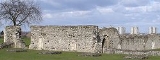
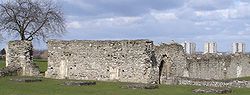
Lesnes Abbey
Encyclopedia
Abbey
An abbey is a Catholic monastery or convent, under the authority of an Abbot or an Abbess, who serves as the spiritual father or mother of the community.The term can also refer to an establishment which has long ceased to function as an abbey,...
, now ruined, in Abbey Wood
Abbey Wood
Abbey Wood is a district of South-East London, England, located mostly in the London Borough of Greenwich, and partly within the London Borough of Bexley. It is situated east of Charing Cross.-Development:...
, in the London Borough of Bexley
London Borough of Bexley
The London Borough of Bexley lies in south east Greater London, and is a borough referred to as part of Outer London. It has common borders with the London Borough of Bromley to the south, the London Borough of Greenwich to the west, across the River Thames to the north it borders the London...
. It is a scheduled ancient monument
Scheduled Ancient Monument
In the United Kingdom, a scheduled monument is a 'nationally important' archaeological site or historic building, given protection against unauthorized change. The various pieces of legislation used for legally protecting heritage assets from damage and destruction are grouped under the term...
and the adjacent park and heath are a Site of Special Scientific Interest
Site of Special Scientific Interest
A Site of Special Scientific Interest is a conservation designation denoting a protected area in the United Kingdom. SSSIs are the basic building block of site-based nature conservation legislation and most other legal nature/geological conservation designations in Great Britain are based upon...
. The ruins are adjacent to Lesnes Abbey Woods
Lesnes Abbey Woods
Lesnes Abbey Woods, sometimes known as Abbey Wood, is an area of ancient woodland in southeast London, England. It is located near to, and named after, the ruined Lesnes Abbey in the London Borough of Bexley and gives its name to the Abbey Wood district...
.
History
After the Norman Conquest in 1066 the area of Lesnes, close to the town of ErithErith
Erith is a district of southeast London on the River Thames. Erith's town centre has undergone a series of modernisations since 1961.-Pre-medieval:...
passed into the possession of Bishop Odo and is mentioned in the Domesday Survey. The year 1178 saw the foundation of the Abbey of St Mary and St Thomas the Martyr at Lesnes.
Lesnes Abbey, as it is known, was founded by Richard de Luci
Richard de Luci
Richard de Luci was first noted as Sheriff of the County of Essex, then he was made Chief Justiciar of England.- Biography :His wife Rohese, who is named in several documents, was a sister of Faramus of Boulogne...
, Chief Justiciar
Justiciar
In medieval England and Ireland the Chief Justiciar was roughly equivalent to a modern Prime Minister as the monarch's chief minister. Similar positions existed on the Continent, particularly in Norman Italy. The term is the English form of the medieval Latin justiciarius or justitiarius In...
of England
England
England is a country that is part of the United Kingdom. It shares land borders with Scotland to the north and Wales to the west; the Irish Sea is to the north west, the Celtic Sea to the south west, with the North Sea to the east and the English Channel to the south separating it from continental...
, in 1178. It is speculated, this may have been in penance for the murder of Thomas Becket
Thomas Becket
Thomas Becket was Archbishop of Canterbury from 1162 until his murder in 1170. He is venerated as a saint and martyr by both the Roman Catholic Church and the Anglican Communion...
, in which he was involved. In 1179, de Luci resigned his office and retired to the Abbey, where he died three months later. He was buried in the chapter house.
The abbey is situated in the suburbs of south east London, in the north of an ancient but long-managed Lesnes Abbey Woods
Lesnes Abbey Woods
Lesnes Abbey Woods, sometimes known as Abbey Wood, is an area of ancient woodland in southeast London, England. It is located near to, and named after, the ruined Lesnes Abbey in the London Borough of Bexley and gives its name to the Abbey Wood district...
that are named after it, where the land rises above what would originally have been marshland.
In 1381 Abel Ker of Erith led a local uprising linked to the famous Peasants' Revolt
Peasants' Revolt
The Peasants' Revolt, Wat Tyler's Rebellion, or the Great Rising of 1381 was one of a number of popular revolts in late medieval Europe and is a major event in the history of England. Tyler's Rebellion was not only the most extreme and widespread insurrection in English history but also the...
. It actually began in Essex but a mob from Erith burst in to nearby Lesnes Abbey and forced the abbot to swear an oath to support them. After this they marched to Maidstone to
join the main body of men led by Wat Tyler
Wat Tyler
Walter "Wat" Tyler was a leader of the English Peasants' Revolt of 1381.-Early life:Knowledge of Tyler's early life is very limited, and derives mostly through the records of his enemies. Historians believe he was born in Essex, but are not sure why he crossed the Thames Estuary to Kent...
. http://www.bexley.gov.uk/localstudies/history_pdfs/11_erith.pdf
The Abbott of Lesnes Abbey was an important local landlord, and took a leading part in draining the marshland. However, this and the cost of maintaining river embankments was one of the reasons given for the Abbey's chronic financial difficulties. It never became a
large community, and was closed by Cardinal Wolsey in 1525, under a licence to suppress monasteries of less than seven inmates.
It was one of the first monasteries to be closed after the Dissolution of the Monasteries
Dissolution of the Monasteries
The Dissolution of the Monasteries, sometimes referred to as the Suppression of the Monasteries, was the set of administrative and legal processes between 1536 and 1541 by which Henry VIII disbanded monasteries, priories, convents and friaries in England, Wales and Ireland; appropriated their...
in 1524, and the monastic buildings were all pulled down, except for the Abbott's Lodging. Henry Cooke acquired the site in 1541 and it eventually passed to Sir John Hippersley who salvaged building materials, before selling the property to Thomas Hawes of London in 1632. It was then bequeathed to Christ's Hospital in 1633. Some of the stone is said to have been used in the construction of Hall Place
Hall Place
Hall Place is a former stately home, today a Grade I listed building and Scheduled Ancient Monument, beside the River Cray on the outskirts of Crayford, west of Bexleyheath and north-east of Old Bexley...
in nearby Bexley
Bexley
Bexley is an South East London]] in the London Borough of Bexley, London, England. It is located on the banks of the River Cray south of the Roman Road, Watling Street...
.
The abbey was effectively lost and the area became farmland with the abbots house forming part of a farmhouse. It has been restored to show some of the walls and the entire outline of the abbey is visible giving a good idea of the size and atmosphere of the original place.
It is on the Green Chain Walk and well worth a visit as it is surrounded by good parkland and an ornamental garden. There is a cafe and a small exhibition of the abbey and also toilet facilities for visitors.
The is a low, leaning tree at the Northern side of the abbey, and this is reputed to be a mulberry tree.
The site was excavated by Woolwich & District Antiquarian Society in 1909-1910 approx. Some archaeological finds from the Abbey's site are displayed in Plumstead
Plumstead
Plumstead is a district of south London, England, located in the London Borough of Greenwich. Plumstead is a multi cultural area with large Asian and Afro-Caribbean communities, in similarity to local areas such as Woolwich and Thamesmead...
Museum at 232 Plumstead High Street, others are further east in the museum above Erith
Erith
Erith is a district of southeast London on the River Thames. Erith's town centre has undergone a series of modernisations since 1961.-Pre-medieval:...
Library in Walnut Tree Road. The "Missale de Lesnes" is in the library of the Victoria & Albert Museum in Exhibition Road, London.
The former London County Council
London County Council
London County Council was the principal local government body for the County of London, throughout its 1889–1965 existence, and the first London-wide general municipal authority to be directly elected. It covered the area today known as Inner London and was replaced by the Greater London Council...
purchased the site of the ruins in 1930, which were opened to the public as a park in 1931. Since 1986, the site has been the property
Property
Property is any physical or intangible entity that is owned by a person or jointly by a group of people or a legal entity like a corporation...
of the London Borough of Bexley
London Borough of Bexley
The London Borough of Bexley lies in south east Greater London, and is a borough referred to as part of Outer London. It has common borders with the London Borough of Bromley to the south, the London Borough of Greenwich to the west, across the River Thames to the north it borders the London...
. A branch of the Green Chain Walk
South East London Green Chain
The South East London Green Chain, also known as the Green Chain Walk is a linked system of open spaces between the River Thames and Crystal Palace Park in London, England. In 1977 four London Boroughs and the Greater London Council created this Green Chain of 300 open spaces to protect them from...
passes the ruins on its way from Oxleas Wood
Oxleas Wood
Oxleas Wood is one of the few remaining areas of ancient deciduous forest in the London Borough of Greenwich in southeast London, dating back over 8,000 years...
to Thamesmead
Thamesmead
Thamesmead is a district of south-east London, England, located in the London Boroughs of Greenwich and Bexley. It is situated east of Charing Cross....
riverside.
Lesnes Abbey ward
Today Lesnes Abbey gives it name to one of the 21 electoral wardsWards of the United Kingdom
A ward in the United Kingdom is an electoral district at sub-national level represented by one or more councillors. It is the primary unit of British administrative and electoral geography .-England:...
that the London Borough of Bexley is divided into. The ruins themselves are in the north of Lesnes Abbey ward. Woolwich Road, the A206 road
A206 road
The A206 road links Greenwich with Greenhithe following the line of the River Thames. Today it is approximately 15 miles in length, although the final section is a relatively new road. Its primary purpose is to link into the London Orbital motorway at the Dartford Crossing and is heavily used by...
cuts through the middle of the ward spanning east to west; the A2041 road spans north to south marking the ward's western boundary. West Heath
West Heath, London
West Heath is a district located within the electoral wards of Lesnes Abbey in the London Borough of Bexley. It is located east of Charing Cross, and is on the A206 road, which is called Woolwich road in the area.-Education:-Nearest places:*Abbey Wood*Belvedere*Lessness Heath*Plumstead...
is located within the ward to the south of Woolwich road. Lesnes Abbey ward is 2.5 km (1.6 mi) long north to south at its longest point, and little under 1.5 km (0.93205910497471 mi) at its widest point east to east.