

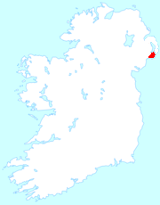
Lecale peninsula
Encyclopedia
Ulster
Ulster is one of the four provinces of Ireland, located in the north of the island. In ancient Ireland, it was one of the fifths ruled by a "king of over-kings" . Following the Norman invasion of Ireland, the ancient kingdoms were shired into a number of counties for administrative and judicial...
, on the southeastern side of County Down
County Down
-Cities:*Belfast *Newry -Large towns:*Dundonald*Newtownards*Bangor-Medium towns:...
, covering an area of some 78 square miles (202 km²) between Downpatrick
Downpatrick
Downpatrick is a medium-sized town about 33 km south of Belfast in County Down, Northern Ireland. It is the county town of Down with a rich history and strong connection to Saint Patrick. It had a population of 10,316 at the 2001 Census...
and Dundrum
Dundrum, County Down
Dundrum is a village and townland in County Down, Northern Ireland. It is beside Dundrum Bay, about 4 miles outside Newcastle on the A2 road. The town is best known for its ruined Norman castle. It had a population of 1,065 people in the 2001 Census....
. It is an area of historical and geographic significance, bounded by the Quoile Marshes (now drained, but formerly extensive), the Blackstaff River
Blackstaff River
Blackstaff River is a watercourse that flows along the M1 Motorway and then through a series of piped sections under Belfast, discharging into Belfast Lough....
, the Irish Sea
Irish Sea
The Irish Sea separates the islands of Ireland and Great Britain. It is connected to the Celtic Sea in the south by St George's Channel, and to the Atlantic Ocean in the north by the North Channel. Anglesey is the largest island within the Irish Sea, followed by the Isle of Man...
and Strangford Lough
Strangford Lough
Strangford Lough, sometimes Strangford Loch, is a large sea loch or inlet in County Down, Northern Ireland. It is separated from the Irish Sea by the Ards Peninsula. The name Strangford is derived ; describing the fast-flowing narrows at its mouth...
. It has an oddly isolated position, virtually cut off from its hinterland, but open to invasion and influence from the east and south.
Derivation of name
It was formerly known as Isle Lecale. The name Lecale is derived from the IrishIrish language
Irish , also known as Irish Gaelic, is a Goidelic language of the Indo-European language family, originating in Ireland and historically spoken by the Irish people. Irish is now spoken as a first language by a minority of Irish people, as well as being a second language of a larger proportion of...
Leath Cathail which means "Cathal's portion"; Cathal mac Muiredaig being a prince of the Dál Fiatach
Dál Fiatach
The Dál Fiatach were a group of related dynasties located in eastern Ulster in the Early Christian and Early Medieval periods of the history of Ireland.-Description:...
who died in the middle of the 8th century. An even earlier name Magh-Inis - "the island plain" - reflected the area's geography, which is surrounded on three sides by the sea. Indeed some people in the area still use the name Isle Lecale.
Features
Until about 200 years ago, when the first sea barriers were constructed and drainage began, the sea encircled almost the whole of the area: Strangford Lough, the Irish Sea and Dundrum Bay. There are a few small hills. On Slieve Patrick stands a giant statue of Saint PatrickSaint Patrick
Saint Patrick was a Romano-Briton and Christian missionary, who is the most generally recognized patron saint of Ireland or the Apostle of Ireland, although Brigid of Kildare and Colmcille are also formally patron saints....
, erected in 1932.
Agriculture
The soils are mostly light-medium loamLoam
Loam is soil composed of sand, silt, and clay in relatively even concentration . Loam soils generally contain more nutrients and humus than sandy soils, have better infiltration and drainage than silty soils, and are easier to till than clay soils...
s, well suited for the production of grain, and it forms one of the most extensively cultivated areas of Northern Ireland. This was also the case historically. Ordnance Survey
Ordnance Survey
Ordnance Survey , an executive agency and non-ministerial government department of the Government of the United Kingdom, is the national mapping agency for Great Britain, producing maps of Great Britain , and one of the world's largest producers of maps.The name reflects its creation together with...
memoirs of 1833 to 1837 state that in some parishes, such as Dunsfort and Ballee, the land was almost exclusively used for cultivation, rather than grazing. The low livestock density meant that marl
Marl
Marl or marlstone is a calcium carbonate or lime-rich mud or mudstone which contains variable amounts of clays and aragonite. Marl was originally an old term loosely applied to a variety of materials, most of which occur as loose, earthy deposits consisting chiefly of an intimate mixture of clay...
and lime
Agricultural lime
Agricultural lime, also called aglime, agricultural limestone, garden lime or liming, is a soil additive made from pulverized limestone or chalk. The primary active component is calcium carbonate...
was often used instead of manure. Arthur Young observed that the area was almost completely under grain cultivation (largely barley
Barley
Barley is a major cereal grain, a member of the grass family. It serves as a major animal fodder, as a base malt for beer and certain distilled beverages, and as a component of various health foods...
) during the late 18th century and that south Lecale was more fertile than the north.
Lecale Coast AONB
In 1967, a 3108ha area of the Lecale Peninsula, lying between the Mourne Mountains and Strangford Lough, was designated as the Lecale Coast Area of Outstanding Natural BeautyLecale Coast AONB
The Lecale Coast AONB is an Area of Outstanding Natural Beauty on the Lecale peninsula in County Down, Northern Ireland. It is located between Strangford Lough and the Mourne Mountains and has a low, sometimes sandy, rocky or grassy shoreline. Its southern tip lies along an extensive sand dune...
.