

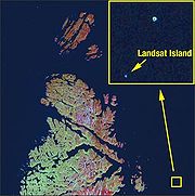
Landsat Island
Encyclopedia
Labrador
Labrador is the distinct, northerly region of the Canadian province of Newfoundland and Labrador. It comprises the mainland portion of the province, separated from the island of Newfoundland by the Strait of Belle Isle...
(part of the Canadian
Canada
Canada is a North American country consisting of ten provinces and three territories. Located in the northern part of the continent, it extends from the Atlantic Ocean in the east to the Pacific Ocean in the west, and northward into the Arctic Ocean...
province of Newfoundland and Labrador
Newfoundland and Labrador
Newfoundland and Labrador is the easternmost province of Canada. Situated in the country's Atlantic region, it incorporates the island of Newfoundland and mainland Labrador with a combined area of . As of April 2011, the province's estimated population is 508,400...
). It was discovered in 1973 during the analysis of imagery from the Landsat 1
Landsat 1
Landsat 1, originally named "Earth Resources Technology Satellite 1", was the first satellite of the United States' Landsat program. It was a modified version of the Nimbus 4 meteorological satellite and was launched on July 23, 1972 by a Delta 900 rocket from Vandenberg Air Force Base in California...
satellite. Its total area is only 25 m by 45 m (1,125 m²).
Discovery
In 1976, a Canadian coastal survey was carried out using data from the Landsat 1 satellite. Analysis of the data revealed several previously uncharted features including Landsat Island, which was subsequently named after the satellite. Verification of the island's existence fell to Dr. Frank Hall of the Canadian Hydrographic ServiceCanadian Hydrographic Service
The Canadian Hydrographic Service is Canada's hydrographic office, with responsibility for performing hydrographic surveys and publishing paper and electronic nautical charts...
:
Following Dr. Hall's encounter with the polar bear, it was suggested that the island be named "Polar Island", but the present name was retained.
Landsat Island marks the eastern most point of the Canadian land mass on the Labrador coast. As such, its discovery increased Canada's territory by 68 km².
Flora and fauna
As Landsat Island is completely covered with ice, no plants are known to exist there. As experienced by Dr. Hall, however, it appears that polar bearPolar Bear
The polar bear is a bear native largely within the Arctic Circle encompassing the Arctic Ocean, its surrounding seas and surrounding land masses. It is the world's largest land carnivore and also the largest bear, together with the omnivorous Kodiak Bear, which is approximately the same size...
s frequent the island. As of 2006, no extensive studies of flora or fauna have been conducted there.
External links
- NASA article: Landsat Island (April 19, 2006)
- David H. Gray, "Discovering Rocks off Labrador: A Photo Essay", IBRU Boundary and Security Bulletin, Summer 2000.