

Lambert Glacier
Encyclopedia
Lambert Glacier is a major glacier
Glacier
A glacier is a large persistent body of ice that forms where the accumulation of snow exceeds its ablation over many years, often centuries. At least 0.1 km² in area and 50 m thick, but often much larger, a glacier slowly deforms and flows due to stresses induced by its weight...
in East Antarctica
East Antarctica
East Antarctica, also called Greater Antarctica, constitutes the majority of the Antarctic continent, lying on the Indian Ocean side of the Transantarctic Mountains...
. At about 60 miles (100 km) wide, over 250 miles (400 km) long, and about 2,500 meters deep, it holds the Guinness world record for the world's largest glacier
Glacier
A glacier is a large persistent body of ice that forms where the accumulation of snow exceeds its ablation over many years, often centuries. At least 0.1 km² in area and 50 m thick, but often much larger, a glacier slowly deforms and flows due to stresses induced by its weight...
. It drains 8 % of the Antarctic ice sheet
Ice sheet
An ice sheet is a mass of glacier ice that covers surrounding terrain and is greater than 50,000 km² , thus also known as continental glacier...
to the east and south of the Prince Charles Mountains
Prince Charles Mountains
Prince Charles Mountains is a major group of mountains in Mac. Robertson Land in Antarctica, including the Athos Range, the Porthos Range, and the Aramis Range. The highest peak is Mount Menzies . Other prominent peaks are Mount Izabelle and Mount Stinear...
and flows northward to the Amery Ice Shelf
Amery Ice Shelf
The Amery Ice Shelf is a broad ice shelf in Antarctica at the head of Prydz Bay between the Lars Christensen Coast and Ingrid Christensen Coast. It is part of Mac. Robertson Land. The name "Cape Amery" was applied to a coastal angle mapped on February 11, 1931 by the British Australian New Zealand...
.
This glacier was delineated and named in 1952 by American geographer John H. Roscoe who made a detailed study of this area from aerial photographs taken by USN Operation Highjump
Operation Highjump
Operation Highjump , officially titled The United States Navy Antarctic Developments Program, 1946-1947, was a United States Navy operation organized by RADM Richard E. Byrd Jr. USN, , Officer in Charge, Task Force 68, and led by RADM Richard H. Cruzen, USN, Commanding Officer, Task Force 68....
, 1946-47. He gave the name "Baker Three Glacier", using the code name of the Navy photographic aircraft and crew that made three flights in this coastal area in March 1947 resulting in geographic discoveries. The glacier was described in Gazetteer No. 14, Geographic Names of Antarctica (U.S. Board on Geographic Names, 1956), but the feature did not immediately appear on published maps. As a result the name Lambert Glacier, as applied by ANCA in 1957 following mapping of the area by ANARE (Australian National Antarctic Research Expeditions
Australian National Antarctic Research Expeditions
The Australian National Antarctic Research Expeditions is the historical name for the Australian Antarctic Program administered for Australia by the Australian Antarctic Division .-The ANARE Name:...
) in 1956, has become established for this feature. Named for Bruce P. Lambert, Director of National Mapping in the Australian Department of National Development. It is flows in part of Lambert Graben and exits the continent at Prydz Bay
Prydz Bay
Prydz Bay is a deep embayment of Antarctica between the Lars Christensen Coast and Ingrid Christensen Coast. Portions of the bay were sighted in January and February 1931 by Norwegian whalers and the British Australian New Zealand Antarctic Research Expedition...
.
Remote sensing
The glacier is important in the study of climate changeClimate change
Climate change is a significant and lasting change in the statistical distribution of weather patterns over periods ranging from decades to millions of years. It may be a change in average weather conditions or the distribution of events around that average...
because very small changes in the climate can have significant consequences for the flow of ice down the glacier. Most studies of the Lambert glacier are done with remote sensing
Remote sensing
Remote sensing is the acquisition of information about an object or phenomenon, without making physical contact with the object. In modern usage, the term generally refers to the use of aerial sensor technologies to detect and classify objects on Earth by means of propagated signals Remote sensing...
due to the harsh conditions in the area.
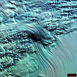
The photo reproduced here (above) shows a small tributary right-flank glacier flowing down from the ice-covered East Antarctic Plateau, flanked by slower-moving ice flowing down over a steep escarpment. The ice-fall which so impressively illustrates the flow characteristics of glacier ice is only about 6 km wide, and Lambert Glacier proper is off the bottom right corner of the photo. The ice here is flowing at about 500 m per year, but velocities of over 1200 m per year are known at the edge of the Amery Ice Shelf, which is fed by this gigantic stream of ice.
On the lower photo north is at the bottom, and the ice velocities are approximately as follow:
- Brown areas—up to 50 m per year.
- Green areas—up to 250 m per year.
- Blue areas—up to 500 m per year.
- Purple areas—around 1000 m per year.
- Red area—up to 1200 m per year.
See also
- Ice streamIce streamAn ice stream is a region of an ice sheet that moves significantly faster than the surrounding ice. Ice streams are a type of glacier. They are significant features of the Antarctic where they account for 10% of the volume of the ice...
- List of glaciers in the Antarctic
- List of Antarctic ice streams