
Laguna de Cotacotani
Encyclopedia
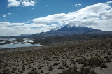
Laguna de Cotacotani is a lake
located in the Andean
altiplano
of the Parinacota Province
, Arica-Parinacota Region
, Chile
. It lies 4 km northwest of Chungará Lake, which is one of the highest lakes in the world and is surrounded by several volcanoes, such as the group formed by the Nevados de Payachata
(Parinacota and Pomerape
), the Nevado Sajama
and the Guallatiri
.
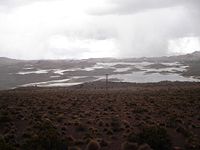
Laguna de Cotacotani is separated from the lake Chungará by a strip of volcanic rock and receives groundwater inflow from that lake, however its major sources are Benedicto Morales River and El Encuentro Creek. Cotacotani Lake's main feature is the considerable number of islands and islets that it holds, which are really lava hummocks generated by a past volcanic event. With a surface of 6 km², the Cotacotani holds a volume of water between 30 to 40 million of m³, which empty through Lauca River
into Coipasa Lake, in Bolivia
.
Although much of its present hummocky topography is related to a large volcanic debris avalanche occurred in the zone, this lacustrine area was not originated by such event. Recent investigations suggests that Cotacotani originated as a series of kettle hole ponds.
Cotacotani lies close to the Route CH-11, which connects Arica
and La Paz via Tambo Quemado International Pass. The lake is located about 54 km east of Putre
and 9 km west of the border with Bolivia, within Lauca National Park
.
Lake
A lake is a body of relatively still fresh or salt water of considerable size, localized in a basin, that is surrounded by land. Lakes are inland and not part of the ocean and therefore are distinct from lagoons, and are larger and deeper than ponds. Lakes can be contrasted with rivers or streams,...
located in the Andean
Andes
The Andes is the world's longest continental mountain range. It is a continual range of highlands along the western coast of South America. This range is about long, about to wide , and of an average height of about .Along its length, the Andes is split into several ranges, which are separated...
altiplano
Altiplano
The Altiplano , in west-central South America, where the Andes are at their widest, is the most extensive area of high plateau on Earth outside of Tibet...
of the Parinacota Province
Parinacota Province
Parinacota Province is one of two provinces of the Chilean region of Arica and Parinacota . Its capital is Putre. It is named after the Parinacota Volcano.-History:...
, Arica-Parinacota Region
Arica-Parinacota Region
The XV Arica and Parinacota Region is one of Chile's 15 first order administrative divisions. It borders Peru to the north, Bolivia to the east and Chile's Tarapacá Region to the south. It is also the country's newest region, created under Law 20.175. It became operational on October 8, 2007...
, Chile
Chile
Chile ,officially the Republic of Chile , is a country in South America occupying a long, narrow coastal strip between the Andes mountains to the east and the Pacific Ocean to the west. It borders Peru to the north, Bolivia to the northeast, Argentina to the east, and the Drake Passage in the far...
. It lies 4 km northwest of Chungará Lake, which is one of the highest lakes in the world and is surrounded by several volcanoes, such as the group formed by the Nevados de Payachata
Nevados de Payachata
Nevados de Payachata is a north-south trending complex of potentially active volcanos on the border of Bolivia and Chile, directly north of Chungará Lake. The complex contains two peaks, Pomerape to the north and Parinacota to the south. According to helium surface dating, Parinacota has erupted...
(Parinacota and Pomerape
Pomerape
Pomerape is a stratovolcano lying on the border of Chile and Bolivia . It is part of the Nevados de Payachata complex of volcanoes together with Parinacota Volcano to the south. It is of Pleistocene age.Climbing the volcano is alpine AD grade, sometimes on 50+ degree snow/rubble slope...
), the Nevado Sajama
Nevado Sajama
Nevado Sajama is an extinct stratovolcano and the highest peak in Bolivia. The mountain is located in the Oruro Department, Sajama Province, Curahuara de Carangas Municipality, Sajama Canton. It is situated in the Sajama National Park in the southwest area of the country some 16–24 km from...
and the Guallatiri
Guallatiri
Guallatiri is one of the most active volcanoes in northern Chile. It is just west of the border with Bolivia and at the southwestern end of the Nevados de Quimsachata. It is a symmetrical 6,071 m high ice-clad stratovolcano...
.
Laguna de Cotacotani is separated from the lake Chungará by a strip of volcanic rock and receives groundwater inflow from that lake, however its major sources are Benedicto Morales River and El Encuentro Creek. Cotacotani Lake's main feature is the considerable number of islands and islets that it holds, which are really lava hummocks generated by a past volcanic event. With a surface of 6 km², the Cotacotani holds a volume of water between 30 to 40 million of m³, which empty through Lauca River
Lauca River
The Lauca River is a binational river. It originates from Chilean Altiplano of the Tarapacá Region, crosses the Andes and empties into Coipasa Lake, in Bolivia....
into Coipasa Lake, in Bolivia
Bolivia
Bolivia officially known as Plurinational State of Bolivia , is a landlocked country in central South America. It is the poorest country in South America...
.
Although much of its present hummocky topography is related to a large volcanic debris avalanche occurred in the zone, this lacustrine area was not originated by such event. Recent investigations suggests that Cotacotani originated as a series of kettle hole ponds.
Cotacotani lies close to the Route CH-11, which connects Arica
Arica, Chile
Arica is a commune and a port city with a population of 185,269 in the Arica Province of northern Chile's Arica and Parinacota Region, located only south of the border with Peru. The city is the capital of both the Arica Province and the Arica and Parinacota Region...
and La Paz via Tambo Quemado International Pass. The lake is located about 54 km east of Putre
Putre
Putre is a Chilean town and commune, capital of the Parinacota Province in the Arica-Parinacota Region. It is located east of Arica, at an altitude of...
and 9 km west of the border with Bolivia, within Lauca National Park
Lauca National Park
Lauca National Park is located in Chile's far north, in the Andean range. It encompasses an area of 1,379 km² of altiplano and mountains, the latter consisting mainly of enormous volcanoes. Las Vicuñas National Reserve is its neighbour to the south. Both protected areas, along with Salar de Surire...
.