
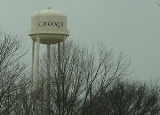
Ladoga, Indiana
Encyclopedia
Ladoga is a town in Clark Township
, Montgomery County
, Indiana
, United States
. The population was 985 at the 2010 census.
on a map of Russia
.
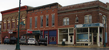
In 1840 there were fifteen buildings in Ladoga, including two large stores selling general merchandise. One owned by Taylor Webster and one owned by William Nofsinger. By 1848, there were thirty families living in the town.
The Haw Creek Academy was built two miles south of Ladoga in 1838 by the Christian Church
. Later, in 1855, the Ladoga Female Seminary was established by the Baptist Church which quickly decided to allow male students, and shortly after the Ladoga Male Academy was established which soon allowed female students. (Both decided to let in the other gender because of financial concerns.)
Central Normal College was founded in Ladoga in 1876; it moved to Danville, Indiana
in 1878. The original building still stands in Ladoga.
. Designed by Pittsburgh, Pennsylvania bridge-builder, George Ferris
, Luther Rice of Ladoga agreed to build it. After the Chicago World's Fair it was placed in Ferris Wheel Park for a while, and then move to St. Louis
for its World's Fair.
According to the United States Census Bureau
, the town has a total area of 0.5 square miles (1.3 km²), all of it land.
 As of the census
of 2000, there were 1,047 people, 385 households, and 286 families residing in the town. The population density
was 2,085.4 people per square mile (808.5/km²). There were 421 housing units at an average density of 838.6 per square mile (325.1/km²). The racial makeup of the town was 98.57% White, 0.19% African American, 0.29% Asian, 0.29% Pacific Islander, 0.29% from other races
, and 0.38% from two or more races. Hispanic or Latino of any race were 0.57% of the population.
There were 385 households out of which 37.9% had children under the age of 18 living with them, 57.9% were married couples
living together, 9.9% had a female householder with no husband present, and 25.5% were non-families. 23.1% of all households were made up of individuals and 12.2% had someone living alone who was 65 years of age or older. The average household size was 2.57 and the average family size was 2.99.
In the town the population was spread out with 26.6% under the age of 18, 7.9% from 18 to 24, 26.9% from 25 to 44, 20.8% from 45 to 64, and 17.7% who were 65 years of age or older. The median age was 37 years. For every 100 females there were 97.5 males. For every 100 females age 18 and over, there were 92.0 males.
The median income for a household in the town was $40,781, and the median income for a family was $43,917. Males had a median income of $31,100 versus $24,135 for females. The per capita income
for the town was $16,163. About 6.4% of families and 7.7% of the population were below the poverty line, including 12.1% of those under age 18 and 8.7% of those age 65 or over.
Clark Township, Montgomery County, Indiana
Clark Township is one of eleven townships in Montgomery County, Indiana, USA. As of the 2000 census, its population was 1,898.-Geography:According to the United States Census Bureau, Clark Township covers an area of ; of this, is land and is water.-Cemeteries:The township contains these six...
, Montgomery County
Montgomery County, Indiana
Montgomery County is a county located in the U.S. state of Indiana. As of 2010, the population was 38,124. The county seat is Crawfordsville-Early history and settlement:...
, Indiana
Indiana
Indiana is a US state, admitted to the United States as the 19th on December 11, 1816. It is located in the Midwestern United States and Great Lakes Region. With 6,483,802 residents, the state is ranked 15th in population and 16th in population density. Indiana is ranked 38th in land area and is...
, United States
United States
The United States of America is a federal constitutional republic comprising fifty states and a federal district...
. The population was 985 at the 2010 census.
History
Ladoga was platted in 1836 by John Meyers. Meyers invited his friends to help him find a name. He required that the name not end in -burg or -ville and that it would not be named after another town. He chose Ladoga after finding Lake LadogaLake Ladoga
Lake Ladoga is a freshwater lake located in the Republic of Karelia and Leningrad Oblast in northwestern Russia, not far from Saint Petersburg. It is the largest lake in Europe, and the 14th largest lake by area in the world.-Geography:...
on a map of Russia
Russia
Russia or , officially known as both Russia and the Russian Federation , is a country in northern Eurasia. It is a federal semi-presidential republic, comprising 83 federal subjects...
.
In 1840 there were fifteen buildings in Ladoga, including two large stores selling general merchandise. One owned by Taylor Webster and one owned by William Nofsinger. By 1848, there were thirty families living in the town.
The Haw Creek Academy was built two miles south of Ladoga in 1838 by the Christian Church
Christian Church
The Christian Church is the assembly or association of followers of Jesus Christ. The Greek term ἐκκλησία that in its appearances in the New Testament is usually translated as "church" basically means "assembly"...
. Later, in 1855, the Ladoga Female Seminary was established by the Baptist Church which quickly decided to allow male students, and shortly after the Ladoga Male Academy was established which soon allowed female students. (Both decided to let in the other gender because of financial concerns.)
Central Normal College was founded in Ladoga in 1876; it moved to Danville, Indiana
Danville, Indiana
Danville is a town in Center Township, Hendricks County, Indiana, United States. The population was 9,001at the 2010 census. The town is the county seat of Hendricks County. -History:...
in 1878. The original building still stands in Ladoga.
Ferris wheel
The town of Ladoga lays claim to the Chicago World's Fair Ferris wheelFerris wheel
A Ferris wheel is a nonbuilding structure consisting of a rotating upright wheel with passenger cars attached to the rim in such a way that as the wheel turns, the cars are kept upright, usually by gravity.Some of the largest and most modern Ferris wheels have cars mounted on...
. Designed by Pittsburgh, Pennsylvania bridge-builder, George Ferris
George Washington Gale Ferris, Jr.
George Washington Gale Ferris, Jr. was an American engineer. He is most famous for creating the original Ferris Wheel for the 1893 Chicago World's Columbian Exposition.-Early life:...
, Luther Rice of Ladoga agreed to build it. After the Chicago World's Fair it was placed in Ferris Wheel Park for a while, and then move to St. Louis
St. Louis, Missouri
St. Louis is an independent city on the eastern border of Missouri, United States. With a population of 319,294, it was the 58th-largest U.S. city at the 2010 U.S. Census. The Greater St...
for its World's Fair.
Geography
Ladoga is located at 39°54′55"N 86°47′57"W (39.915223, -86.799271).According to the United States Census Bureau
United States Census Bureau
The United States Census Bureau is the government agency that is responsible for the United States Census. It also gathers other national demographic and economic data...
, the town has a total area of 0.5 square miles (1.3 km²), all of it land.
Demographics
Census
A census is the procedure of systematically acquiring and recording information about the members of a given population. It is a regularly occurring and official count of a particular population. The term is used mostly in connection with national population and housing censuses; other common...
of 2000, there were 1,047 people, 385 households, and 286 families residing in the town. The population density
Population density
Population density is a measurement of population per unit area or unit volume. It is frequently applied to living organisms, and particularly to humans...
was 2,085.4 people per square mile (808.5/km²). There were 421 housing units at an average density of 838.6 per square mile (325.1/km²). The racial makeup of the town was 98.57% White, 0.19% African American, 0.29% Asian, 0.29% Pacific Islander, 0.29% from other races
Race (United States Census)
Race and ethnicity in the United States Census, as defined by the Federal Office of Management and Budget and the United States Census Bureau, are self-identification data items in which residents choose the race or races with which they most closely identify, and indicate whether or not they are...
, and 0.38% from two or more races. Hispanic or Latino of any race were 0.57% of the population.
There were 385 households out of which 37.9% had children under the age of 18 living with them, 57.9% were married couples
Marriage
Marriage is a social union or legal contract between people that creates kinship. It is an institution in which interpersonal relationships, usually intimate and sexual, are acknowledged in a variety of ways, depending on the culture or subculture in which it is found...
living together, 9.9% had a female householder with no husband present, and 25.5% were non-families. 23.1% of all households were made up of individuals and 12.2% had someone living alone who was 65 years of age or older. The average household size was 2.57 and the average family size was 2.99.
In the town the population was spread out with 26.6% under the age of 18, 7.9% from 18 to 24, 26.9% from 25 to 44, 20.8% from 45 to 64, and 17.7% who were 65 years of age or older. The median age was 37 years. For every 100 females there were 97.5 males. For every 100 females age 18 and over, there were 92.0 males.
The median income for a household in the town was $40,781, and the median income for a family was $43,917. Males had a median income of $31,100 versus $24,135 for females. The per capita income
Per capita income
Per capita income or income per person is a measure of mean income within an economic aggregate, such as a country or city. It is calculated by taking a measure of all sources of income in the aggregate and dividing it by the total population...
for the town was $16,163. About 6.4% of families and 7.7% of the population were below the poverty line, including 12.1% of those under age 18 and 8.7% of those age 65 or over.