Kurihara, Miyagi
Encyclopedia


Cities of Japan
||A is a local administrative unit in Japan. Cities are ranked on the same level as and , with the difference that they are not a component of...
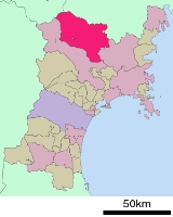
located in Miyagi Prefecture
Miyagi Prefecture
is a prefecture of Japan in the Tōhoku Region on Honshu island. The capital is Sendai.- History :Miyagi Prefecture was formerly part of the province of Mutsu. Mutsu Province, on northern Honshu, was one of the last provinces to be formed as land was taken from the indigenous Emishi, and became the...
, Japan
Japan
Japan is an island nation in East Asia. Located in the Pacific Ocean, it lies to the east of the Sea of Japan, China, North Korea, South Korea and Russia, stretching from the Sea of Okhotsk in the north to the East China Sea and Taiwan in the south...
. As of 2008, the city has an estimated population
Population
A population is all the organisms that both belong to the same group or species and live in the same geographical area. The area that is used to define a sexual population is such that inter-breeding is possible between any pair within the area and more probable than cross-breeding with individuals...
of 77,012 and a population density
Population density
Population density is a measurement of population per unit area or unit volume. It is frequently applied to living organisms, and particularly to humans...
of 95.7 persons per km². The total area is 804.93 km². Previously a district consisting of nine towns and one village, on April 1, 2005, the towns and village merged to form a new city. The new city hall is located at Tsukidate. Though technically referred to as a "city", Kurihara in fact functions more like a county composed of ten separate towns.
During the 2011 Tōhoku earthquake, Kurihara was the only city to report the maximum value of 7 on the Japan Meteorological Agency seismic intensity scale
Japan Meteorological Agency seismic intensity scale
The Japan Meteorological Agency seismic intensity scale is a seismic scale used in Japan and Taiwan to measure the intensity of earthquakes. It is measured in units of...
.
Geography
Kurihara covers the entire northwestern corner of Miyagi PrefectureMiyagi Prefecture
is a prefecture of Japan in the Tōhoku Region on Honshu island. The capital is Sendai.- History :Miyagi Prefecture was formerly part of the province of Mutsu. Mutsu Province, on northern Honshu, was one of the last provinces to be formed as land was taken from the indigenous Emishi, and became the...
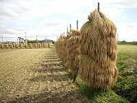
. It is mostly farmland, mostly rice fields, and small mountain ranges throughout, the largest of which cluster around Kurikoma-san, the tallest mountain in Kurihara located at the furthest northwestern point of Miyagi Prefecture.
Weather
Like most of Japan, the summers in Kurihara are hot and humid with temperatures usually around 30 Degrees Celsius. Summer is also typhoon season, however, since Kurihara is so far north and inland the area is rarely affected. The typhoons that do end up hitting the area are often mild without much consequence. Fall and spring are mild, with temperatures in the low to mid 20s (Celsius). In fall the days usually begin foggy and cold but clear up by midday. Spring comes late to the region since it is so far North and is mostly sunny punctuated with random light showers. Winter is the longest season in this Northern region. The temperature fluctuates around 0 Degrees Celsius, falling to an average low of -10 Degrees Celsius, and snow levels vary from town to town. Since Kurikoma and Hanayama towns are more mountainous their snowfall is significantly greater compared to Shiwahime and Tsukidate which are in flatter areas.Seasons
Kurihara has an abundance of natural beauty in all of its seasons. Spring is the time for cherry blossoms, arguably the most beautiful season in Japan. In summer the lotus petals on Lake Izunuma bloom. In fall Mt. Kurikoma is covered in fall colors and in winter migrating swans and geese come in flocks to spend the season on Kurihara's lakes.Sights to see
Mt. Kurikoma:- Mt. Kurikoma is a dormant volcano straddling the tri-prefectural border of MiyagiMiyagi Prefectureis a prefecture of Japan in the Tōhoku Region on Honshu island. The capital is Sendai.- History :Miyagi Prefecture was formerly part of the province of Mutsu. Mutsu Province, on northern Honshu, was one of the last provinces to be formed as land was taken from the indigenous Emishi, and became the...
, AkitaAkita Prefectureis a prefecture of Japan located in the Tōhoku Region of northern Honshu, the main island of Japan. The capital is the city of Akita.- History :The area of Akita has been created from the ancient provinces of Dewa and Mutsu....
and IwateIwate Prefectureis the second largest prefecture of Japan after Hokkaido. It is located in the Tōhoku region of Honshū island and contains the island's easternmost point. The capital is Morioka. Iwate has the lowest population density of any prefecture outside Hokkaido...
. It is 1627 meters high, conical, and has a 365 degree panoramic view. There is an abundance of diverse alpine floraAlpine plantAlpine plants are plants that grow in the alpine climate, which occurs at high elevation and above the tree line. Alpine plants grow together as a plant community in alpine tundra.-Alpine plant diversity:...
in the wetlands near its peak and expansive virgin beech forests that are home to many precious birds, insects, and other fauna. There are extensive hiking trails with hot springs located at the base and top of the mountain.
Sekai Yachi Wetlands Flower Park:
- This 14.34-hectareHectareThe hectare is a metric unit of area defined as 10,000 square metres , and primarily used in the measurement of land. In 1795, when the metric system was introduced, the are was defined as being 100 square metres and the hectare was thus 100 ares or 1/100 km2...
wetlands area is situated in the southern foothills of Mt. Kurikoma, between 669 and 707 meters above sea level. Late June is the best time to see the Middendorff's daylilies. The flowering seasons are spring and summer.
Lake Izunuma and Lake Uchinuma:
- Izunuma once covered 420 hectares but was drained in the last century to just 289 hectares. It is the largest freshwater lake in Miyagi. Migrating birds including swanSwanSwans, genus Cygnus, are birds of the family Anatidae, which also includes geese and ducks. Swans are grouped with the closely related geese in the subfamily Anserinae where they form the tribe Cygnini. Sometimes, they are considered a distinct subfamily, Cygninae...
s, geese, and ducks, winter here. It is also the site of the Miyagi Prefectural Sanctuary Center of Izunuma-Uchinuma which was created in order to protect the abundant plant and animal life in the area. Izunuma is home to 223 species of waterfowl, or 42% of Japan's 535 total water bird. Also, from late July to late August is when the Lotus flowers bloom and the Izunuma-Uchinuma Lotus Festival is held.
There are also a number of beautiful waterfalls, parks filled with cherry blossoms in spring, and flower gardens. These include: Abazu Gorge, Shiraito Falls, Gorindoyama Park, Hasama River Park, and Sanno Historic Park Iris Garden.
Culture
Kurihara is known for the abundant, high-quality rice it produces. It is also a renowned place for viewing the leaves change in Fall as Mt. Kurikoma gets some of the best fall colors. Kurihara also has an abundance of hot springsHot Springs
Hot Springs may refer to:* Hot Springs, Arkansas** Hot Springs National Park, Arkansas*Hot Springs, California**Hot Springs, Lassen County, California**Hot Springs, Modoc County, California**Hot Springs, Placer County, California...
which tourists flock to in winter in order to warm up. These include: Yu no Kura Hot Spring, Yubama Hot Spring, Hanayama Hot Spring, and Nuruyu Hot Spring.
Festivals
- Late March Tohoku Draft Horse Pull Kurikoma Tournament (Kurikoma)
- 1st Sun of April Obasama Festival and Longevity Rites (Kannari)
- Mid-April Izumiya Oyashiki Festival (Semine)
- April 29 Masaoka Festival (Ichihasama)
- Mid-April Cherry Blossom Festivals (all areas)
- May 5 Hanayama Rifle Festival (Hanayama)
- Mid-June Iris Festival (Ichihasama)
- Mid-June Ichihasama Lily Garden Opening (Ichihasama)
- 1st Sun of July Iris Festival and Kagura Sacred Dance (Ichihasama)
- 3rd Sun of July Michinoku Kagura Sacred Dance Festival (Tsukidate)
- Late July Kurikoma Float Parade Festival (Kurikoma)
- August Izunuma-Uchinuma Lotus Festival (Wakayanagi, Tsukidate)
- August 5–6 Tsukidate Tanabata Festival (Tsukidate)
- August 14 Waterwheel (Suisha) Festival (Shiwahime)
- August 15–16 Wakayanagi Summer Festival (Wakayanagi)
- Early October Autumn Lake Festival (Hanayama)
- Oct-Nov Tagaiichi Markets and Festivals
- November 3 Tsukidate Yakushi Festival
- Early Nov Industries Festival
- Dec-Feb Festivals to Beckon and Welcome Spring (all areas)
- Mid-Jan Donto Festivals (all areas)
Train stations
- Tōhoku ShinkansenTohoku ShinkansenThe is a Japanese high-speed Shinkansen rail line, connecting Tokyo with Aomori in Aomori Prefecture for a total length of 674 km, Japan's longest Shinkansen line. It runs through the more sparsely populated Tōhoku region of Japan's main island Honshu. It has two spur lines, Yamagata...
: Kurikoma-KōgenKurikoma-Kogen Stationis a railway station operated by JR East on the Tōhoku Shinkansen. It is located in Kurihara, Miyagi, Japan. In 2006, there were 1,206 daily boardings at Kurikoma-Kōgen station, about 440,190 annually, 4% down from 2005's 1,251 daily boardings.-Station layout:...
(Shiwahime) - Tōhoku Main Line: SemineSemine Stationis a railway station located on the JR Tōhoku Main Line in Kurihara, Miyagi Prefecture, Japan.-Adjacent stations:...
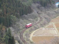
, ArikabeArikabe Stationis a railway station located on the JR Tōhoku Main Line in Kurihara, Miyagi Prefecture, Japan.-Adjacent stations:... - Most of the former stations of the Kurihara Den'en Railway (decommissioned on March 31, 2007) were located in Kurihara: IshikoshiIshikoshi Stationthumb|Ishikoshi Station is a railway station on the JR East Tōhoku Main Line. It is located in Tome, Miyagi, Japan.- History :*April 16, 1890: Station begins operation on what is now the Tōhoku Main Line....
- AramachiAramachi Station (Miyagi)was a station located on the Kurihara Den'en Railway Company Kurihara Den'en Railway Line in Kurihara, Miyagi Prefecture, Japan.-Adjacent stations:...
- WakayanagiWakayanagi Stationthumb|Wakayanagi Station was a station located on the Kurihara Den'en Railway Company Kurihara Den'en Railway Line in Kurihara, Miyagi Prefecture, Japan.-Surrounding area:...
- YachihataYachihata Stationwas a train station located on the Kurihara Den'en Railway Company Kurihara Den'en Railway Line in Kurihara, Miyagi Prefecture, Japan.-Adjacent stations:...
- ŌokashōmaeOokashomae Stationwas a train station located on the Kurihara Den'en Railway Company Kurihara Den'en Railway Line in Kurihara, Miyagi Prefecture, Japan....
- ŌokaOoka Station (Miyagi)was a train station located on the Kurihara Den'en Railway Company Kurihara Den'en Railway Line in Kurihara, Miyagi Prefecture, Japan.-Adjacent stations:...
- SawabeSawabe Stationthumb|Sawabe Station was a train station located on the Kurihara Den'en Railway Company Kurihara Den'en Railway Line in Kurihara, Miyagi Prefecture, Japan.-Adjacent stations:...
- TsukumoTsukumo Stationthumb|Tsukumo Station was a train station located on the Kurihara Den'en Railway Company Kurihara Den'en Railway Line in Kurihara, Miyagi Prefecture, Japan.-Adjacent stations:...
- SugihashiSugihashi Stationthumb|Sugihashi Station was a train station located on the Kurihara Den'en Railway Company Kurihara Den'en Railway Line in Kurihara, Miyagi Prefecture, Japan.-Adjacent stations:...
- ToyasakiToyasaki Stationthumb|Toyasaki Station was a train station located on the Kurihara Den'en Railway Company Kurihara Den'en Railway Line in Kurihara, Miyagi Prefecture, Japan.-Adjacent stations:...
- KurikomaKurikoma Stationthumb|Kurikoma Station was a train station located on the Kurihara Den'en Railway Company Kurihara Den'en Railway Line in Kurihara, Miyagi Prefecture, Japan.-History:*December 17, 1922: Station begins operation as Iwagazaki Station....
- Kurihara TamachiKurihara Tamachi Stationwas a train station located on the Kurihara Den'en Railway Company Kurihara Den'en Railway Line in Kurihara, Miyagi Prefecture, Japan.-Adjacent stations:...
- OmatsuOmatsu Stationwas a train station located on the Kurihara Den'en Railway Company Kurihara Den'en Railway Line in Kurihara, Miyagi Prefecture, Japan.-Adjacent stations:...
- UguisuzawaUguisuzawa Stationwas a train station located on the Kurihara Den'en Railway Company Kurihara Den'en Railway Line in Kurihara, Miyagi Prefecture, Japan.-Adjacent stations:...
- Uguisuzawa Kōgyōkōkō MaeUguisuzawa Kogyokoko Mae Stationwas a train station located on the Kurihara Den'en Railway Company Kurihara Den'en Railway Line in Kurihara, Miyagi Prefecture, Japan.-Adjacent stations:...
- Hosokura Mine Park MaeHosokura Mine Park Mae Stationwas a train station located on the Kurihara Den'en Railway Company Kurihara Den'en Railway Line in Kurihara, Miyagi Prefecture, Japan.-History:*December 1, 1942: Station begins operation as Hosokura Station....
Major roads
- Tohoku ExpresswayTohoku ExpresswayThe is a national expressway in Japan. It is owned by Japan Expressway Holding and Debt Repayment Agency and operated by East Nippon Expressway Company.-Naming:Tōhoku refers to the Tōhoku region, the northernmost region on the island of Honshū....
, Route 4Route 4 (Japan)National Route 4 is a major highway in eastern Honshū, Japan. The longest of the ordinary highways in Japan, it originates in Chūō, Tokyo and stretches north for 743.6 km to the city of Aomori in Aomori Prefecture. From Saitama Prefecture to Iwate Prefecture, it parallels the Tōhoku...
, Route 398Route 398 (Japan)National Route 398 is a national highway of Japan connecting Ishinomaki, Miyagi and Yurihonjō, Akita in Japan, with a total length of 273.6 km ....
, Route 457Route 457 (Japan)National Route 457 is a national highway of Japan connecting Ichinoseki, Iwate and Shiroishi, Miyagi in Japan, with a total length of 173.9 km ....
Former towns and villages
- Hanayama
- Ichihasama
- Kannari
- KurikomaKurikoma, Miyagiwas a town in Kurihara District, Miyagi, Japan. Established in 1955 with the consolidation of six municipalities, it was abolished in a merger forming the larger Kurihara City in 2005. The municipal area was 244.36 km² and the population was 13,736 in 2005....
- Semine
- Shiwahime
- Takashimizu
- Tsukidate
- UguisuzawaUguisuzawa, Miyagiwas a town located in Kurihara District, Miyagi, Japan.On April 1, 2005, Uguisuzawa was merged with the towns of Ichihasama, Kannari, Kurikoma, Semine, Shiwahime, Takashimizu, Tsukidate and Wakayanagi, and the village of Hanayama, all from Kurihara District, to form the new city of...
- WakayanagiWakayanagi, Miyagiwas a town located in Kurihara District, Miyagi, Japan.On April 1, 2005, Wakayanagi was merged with the towns of Ichihasama, Kannari, Kurikoma, Semine, Shiwahime, Takashimizu, Tsukidate and Uguisuzawa, and the village of Hanayama, all from Kurihara District, to form the new city of Kurihara.In...

