

Kuranda Range Highway
Encyclopedia
Kennedy Highway
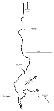
The Kennedy Highway is a highway in northern Queensland, Australia. It runs for approximately 250 km from Smithfield, on the northern outskirts of Cairns, to the Gulf Development Road in the vicinity of Forty Mile Scrub and Undara Volcanic national parks, about 40 kilometres south of Mount...
, located near Cairns (16°50′18"S 145°40′21"E) that traverses the Macalister Range, connecting Smithfield
Smithfield, Queensland
Smithfield, about 15 km to the north of Cairns, Queensland, Australia that was first established in 1876, was a rival for dominance of the area to Cairns at that time...
(a suburb of Cairns) and Kuranda
Kuranda, Queensland
Kuranda is a town on the Atherton Tableland in Far North Queensland, Australia, it is 25 kilometres from Cairns, via the Kuranda Range road. It is surrounded by rainforest. At the 2006 census, Kuranda had a population of 1,611.-History:...
, after which it is named. The winding road is approximately 11.5 kilometres (7.1 mi) long, through rainforest
Rainforest
Rainforests are forests characterized by high rainfall, with definitions based on a minimum normal annual rainfall of 1750-2000 mm...
from sealevel to an altitude 360 metres (1,181.1 ft) metres above sea level at Kuranda. For most of the length of the road, traffic is limited to one lane each way, with overtaking lanes scattered at various points. The Kuranda Skyrail
Kuranda Skyrail
Skyrail Rainforest Cableway is a scenic cableway running above the Barron Gorge National Park from the Cairns suburb of Caravonica to Kuranda, Queensland. The development of Skyrail was controversial as some local residents believed that damage may be done to World Heritage listed rainforest...
cableway crosses the road twice. Henry Ross Lookout is located near the road's highest point, at an altitude of 430 metres (1,410.8 ft), and is named after the foreman in charge of building the road to cross the range in 1939.
History
Construction of the present Kuranda Range road as an alternative to the Gillies Highway began in 1940. This was partly as a result of public demand for better access to the Atherton TablelandAtherton Tableland
The Atherton Tableland is a fertile plateau which is part of the Great Dividing Range in Queensland, Australia. It is located west to south-south-west inland from Cairns, well into the tropics, but its elevated position provides a climate suitable for dairy farming. It has an area of around...
, but also due to strategic wartime use. Whereas the previous Smithfield Track went relatively straight up the spur from Avondale Creek, passing by the present location of Henry Ross Lookout, and emerged at Mountain Grove, the new road took a far more circuitous route.
The Queensland Main Roads
Department of Main Roads (Queensland)
The Queensland Government Department of Transport and Main Roads plans, designs, builds and maintains the 34,000km of Queensland state-controlled roads, under the Minister for Local Government and Main Roads. Warren Pitt is the current Minister for Local Government and Main Roads.The department is...
Commission surveyed, planned and constructed the Cairns-Kuranda road. The initial survey work was undertaken by the Commission Engineer A.J. Bond in 1939 in order to determine whether a grade was feasible. Henry Ross was appointed foreman. Single and married men’s quarters were also established where the Smithfield Shopping Centre now stands. About 100 men built the road, with the aid of bulldozer
Bulldozer
A bulldozer is a crawler equipped with a substantial metal plate used to push large quantities of soil, sand, rubble, etc., during construction work and typically equipped at the rear with a claw-like device to loosen densely-compacted materials.Bulldozers can be found on a wide range of sites,...
s, jackhammer
Jackhammer
A jackhammer is a pneumatic tool that combines a hammer directly with a chisel that was invented by Charles Brady King. Hand-held jackhammers are typically powered by compressed air, but some use electric motors. Larger jackhammers, such as rig mounted hammers used on construction machinery, are...
s and dynamite
Dynamite
Dynamite is an explosive material based on nitroglycerin, initially using diatomaceous earth , or another absorbent substance such as powdered shells, clay, sawdust, or wood pulp. Dynamites using organic materials such as sawdust are less stable and such use has been generally discontinued...
. Although most workers had to walk up and down the range each day to their work area, temporary blacksmith’s shops were set up on site to sharpen jackhammer bits. There were no fatal accidents during construction and the road was completed to the top of the range in approximately 12 months.
Henry Ross chose "The Orange Grove" as the campsite for the second stage of the road into Kuranda. At the time of construction there was a low-level bridge over the Barron River
Barron River (Queensland)
The Barron River is located on the Atherton Tableland inland from Cairns in Northern Queensland, Australia. With its headwater at Lake Tinaroo, it is more than 165 km long and has a catchment area of approximately 2138 km².-History:...
to allow access to rainforest timbers on the eastern side of the river. On completion, the gravel road was predominantly a dual carriageway, however there were parts that were of one-way standard due to their roughness. In 1944 the road was reconditioned, and the Barron River bridge and approaches widened. In the years since, the range road has been improved, widened and re-surfaced many times.
Upgrade project
The state governmentGovernment of Queensland
The Government of Queensland is commonly known as the "Queensland Government".The form of the Government of Queensland is prescribed in its Constitution, which dates from 1859, although it has been amended many times since then...
has proposed that the current two lane road be replaced with a four-lane, raised freeway. The current road would not be usable after the freeway is completed. The use of the controversial Stone mastic asphalt
Stone mastic asphalt
Stone mastic asphalt was developed in Germany in the 1960s. It provides a deformation resistant, durable surfacing material, suitable for heavily trafficked roads. SMA has found use in Europe, Australia, the United States, and Canada as a durable asphalt surfacing option for residential streets...
has been proposed for the new freeway.