
.gif)
Barron River (Queensland)
Encyclopedia
The Barron River is located on the Atherton Tableland
inland from Cairns in Northern Queensland
, Australia
. With its headwater at Lake Tinaroo
, it is more than 165 km long and has a catchment area of approximately 2138 km².
in 1874.
Heavy rain associated with a cyclone early in 1939 caused substantial flooding on the Barron River and resulted in the river changing its course. The mouth of the Barron moved about 2 km north from Casuarina Point on the northern Cairns esplanade to Ellie Point.
 Some of the river's worst flooding occurred in 1950
. This was due to a major tropical cyclone following the contour of the Queensland coast for over a week.
's former headwaters were diverted by natural forces into the Barron. These include the Clohesy River and other tributaries that used to flow northwest to the Gulf of Carpentaria
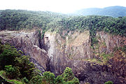
. With the extra water now flowing over the 260 metre high Barron Falls
, the steep, narrow Barron Gorge
was formed. Much of the water that used to flow over the falls has now been diverted in upstream dams and used to generate electricity at the Barron Gorge Hydroelectric Power Station.
The Barron's headwaters start in the Mount Hypipamee National Park
near Mount Hypipamee at an elevation of 1200 m. The river then flows north 65 km across the Atherton Tablelands before finally turning east after Mareeba towards Kuranda
. After passing under the Kuranda Range Highway's
bridge and through Kuranda proper, it descends down the 260 metre high Barron Falls and reaches the Cairns floodplains near Smithfield
. Dinner Falls
are located along the upper Barron River.
 The river's catchment area includes the major tributaries flowing into Lake Tinaroo including Kauri, Mazlin, McLean, Maroobi, Peterson and Severin Creeks. It also absorbs most of the major tributaries on the Atherton Tableland, including Emerald Creek, Granite Creek, the Clohesy River and Stoney Creek
. This also includes Thomatis Creek, which has only been connected to the Barron since 1932 and has been responsible for diverting part of the flow from the river. Freshwater Creek joins the Barron River below the Gorge and drains Lake Morris and the Lamb and Whitfield Ranges.
Before entering the Pacific Ocean
, the river's delta
splits into three distributaries, the main river channel, Thomatis/Richters Creek and Redden Creek. During times of flooding two other distributaries also operate - Barr Creek and Half Moon Creek.
Atherton Tableland
The Atherton Tableland is a fertile plateau which is part of the Great Dividing Range in Queensland, Australia. It is located west to south-south-west inland from Cairns, well into the tropics, but its elevated position provides a climate suitable for dairy farming. It has an area of around...
inland from Cairns in Northern Queensland
Queensland
Queensland is a state of Australia, occupying the north-eastern section of the mainland continent. It is bordered by the Northern Territory, South Australia and New South Wales to the west, south-west and south respectively. To the east, Queensland is bordered by the Coral Sea and Pacific Ocean...
, Australia
Australia
Australia , officially the Commonwealth of Australia, is a country in the Southern Hemisphere comprising the mainland of the Australian continent, the island of Tasmania, and numerous smaller islands in the Indian and Pacific Oceans. It is the world's sixth-largest country by total area...
. With its headwater at Lake Tinaroo
Lake Tinaroo
Lake Tinaroo, also known as Tinaroo Dam, is a man-made reservoir on the Atherton Tableland in Far North Queensland, Australia. It was constructed between 1953 and 1958 on the Barron River close to Lake Barrine and Lake Eacham .- History :...
, it is more than 165 km long and has a catchment area of approximately 2138 km².
History
The river's original Aboriginal name is Bibhoora. The river gained its current name in 1875 when two police sub-inspectors, Johnstone and Douglas, named it after Thomas Henry Bowman Barron (c1835 - 24 June 1882), chief clerk of police in Brisbane. The European discovery of the river was by James Venture MulliganJames Venture Mulligan
James Venture Mulligan was a bushman and prospector. He was born in Drumgooland, County Down, Ireland and emigrated to Australia in 1859...
in 1874.
Flooding
The lower reaches of the Barron River have a well-documented history of flooding dating from early last century. Tinaroo Falls Dams has little effect on the mitigation of floods. Both agricultural and residential areas can be affected. A network of rainfall and river height field stations was established in 1995 to provide a flood warning system for the Cairns City Council.Heavy rain associated with a cyclone early in 1939 caused substantial flooding on the Barron River and resulted in the river changing its course. The mouth of the Barron moved about 2 km north from Casuarina Point on the northern Cairns esplanade to Ellie Point.
1950 Australian rainfall records
The 1950 rainfall records for the Australian states of New South Wales and Queensland reported probably the most remarkable record high rainfall totals ever recorded anywhere in the continent. Averaged over both of these states, 1950 is clearly the wettest year since adequate records became...
. This was due to a major tropical cyclone following the contour of the Queensland coast for over a week.
Geography
Over time, some of the Mitchell RiverMitchell River (Queensland)
The Mitchell River is a river in the Far North Queensland region of Australia. The river begins on the Atherton Tableland about northwest of Cairns, and flows about northwest across Cape York Peninsula from Mareeba to the Gulf of Carpentaria....
's former headwaters were diverted by natural forces into the Barron. These include the Clohesy River and other tributaries that used to flow northwest to the Gulf of Carpentaria
Gulf of Carpentaria
The Gulf of Carpentaria is a large, shallow sea enclosed on three sides by northern Australia and bounded on the north by the Arafura Sea...
. With the extra water now flowing over the 260 metre high Barron Falls
Barron Falls
Barron Falls is where the Barron River makes its descent from the Atherton Tablelands to the Cairns coastal plain, in Queensland, Australia. Protected within the Barron Gorge National Park, the volume of water seen in the upper photo only occurs after substantial rainfall during the wet season...
, the steep, narrow Barron Gorge
Barron Gorge National Park
Barron Gorge National Park is a national park in Queensland , 1,404 km northwest of Brisbane and 2 km from Kuranda. Barron Gorge is part of the Wet Tropics World Heritage Area. The Kuranda Scenic Railway line passes through the park with a station at Barron Falls. One train runs from...
was formed. Much of the water that used to flow over the falls has now been diverted in upstream dams and used to generate electricity at the Barron Gorge Hydroelectric Power Station.
The Barron's headwaters start in the Mount Hypipamee National Park
Mount Hypipamee National Park
Mount Hypipamee is a national park in Queensland, Australia, 1358 km northwest of Brisbane....
near Mount Hypipamee at an elevation of 1200 m. The river then flows north 65 km across the Atherton Tablelands before finally turning east after Mareeba towards Kuranda
Kuranda, Queensland
Kuranda is a town on the Atherton Tableland in Far North Queensland, Australia, it is 25 kilometres from Cairns, via the Kuranda Range road. It is surrounded by rainforest. At the 2006 census, Kuranda had a population of 1,611.-History:...
. After passing under the Kuranda Range Highway's
Kuranda Range Highway
The Kuranda Range road is an informally named section of the Kennedy Highway, located near Cairns that traverses the Macalister Range, connecting Smithfield and Kuranda, after which it is named. The winding road is approximately long, through rainforest from sealevel to an altitude metres above...
bridge and through Kuranda proper, it descends down the 260 metre high Barron Falls and reaches the Cairns floodplains near Smithfield
Smithfield, Queensland
Smithfield, about 15 km to the north of Cairns, Queensland, Australia that was first established in 1876, was a rival for dominance of the area to Cairns at that time...
. Dinner Falls
Dinner Falls
Dinner Falls is a waterfall on the upper Barron River in Far North Queensland, Australia.The waterfall is located south of Atherton on the Atherton Tableland near the Mount Hypipamee Crater in...
are located along the upper Barron River.
Stoney Creek Falls
Stoney Creek Falls are found in the Barron Gorge National Park, north-east of Cairns, in Queensland, Australia. The falls are formed where Stoney Creek starts to descend in steps from the shoulders of the gorge. The falls are best known for the curved lattice railway bridge that passes in front of...
. This also includes Thomatis Creek, which has only been connected to the Barron since 1932 and has been responsible for diverting part of the flow from the river. Freshwater Creek joins the Barron River below the Gorge and drains Lake Morris and the Lamb and Whitfield Ranges.
Before entering the Pacific Ocean
Pacific Ocean
The Pacific Ocean is the largest of the Earth's oceanic divisions. It extends from the Arctic in the north to the Southern Ocean in the south, bounded by Asia and Australia in the west, and the Americas in the east.At 165.2 million square kilometres in area, this largest division of the World...
, the river's delta
River delta
A delta is a landform that is formed at the mouth of a river where that river flows into an ocean, sea, estuary, lake, reservoir, flat arid area, or another river. Deltas are formed from the deposition of the sediment carried by the river as the flow leaves the mouth of the river...
splits into three distributaries, the main river channel, Thomatis/Richters Creek and Redden Creek. During times of flooding two other distributaries also operate - Barr Creek and Half Moon Creek.
Fauna
The stocking of exotic sports fish into the river has led to a serious decline in the diversity and abundance of native fish.See also
- List of rivers of Queensland
- William Walter Mason BridgeWilliam Walter Mason BridgeThe William Walter Mason Memorial Bridge is a road bridge over the Barron River on the Captain Cook Highway in Stratford, Queensland, Australia....