

Kruispolderhaven
Encyclopedia
Zeeuws-Vlaanderen
Zeelandic Flanders is the southernmost region of the province of Zeeland in south-western Netherlands. It lies south of the Western Scheldt that separates the region from the remainder of Zeeland to the north...
portion of the Dutch
Netherlands
The Netherlands is a constituent country of the Kingdom of the Netherlands, located mainly in North-West Europe and with several islands in the Caribbean. Mainland Netherlands borders the North Sea to the north and west, Belgium to the south, and Germany to the east, and shares maritime borders...
province of Zeeland
Zeeland
Zeeland , also called Zealand in English, is the westernmost province of the Netherlands. The province, located in the south-west of the country, consists of a number of islands and a strip bordering Belgium. Its capital is Middelburg. With a population of about 380,000, its area is about...
. Its name originates from its location at the eastern tip of the Kruispolder, a "crossed" polder
Polder
A polder is a low-lying tract of land enclosed by embankments known as dikes, that forms an artificial hydrological entity, meaning it has no connection with outside water other than through manually-operated devices...
adjacent to a (now nonexistent) seaport on the southern bank of the Western Scheldt
Western Scheldt
The Western Scheldt in the province Zeeland in the southwestern Netherlands, is the estuary of the Scheldt river. This river once had several estuaries, but the others are disconnected from the Scheldt, leaving the Westerschelde as its only direct way to the sea. It is an important shipping route...
estuary.
History
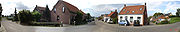
Kruispolderhaven is the harbour of the Kruispolder, which was reclaimed from the sea in 1612 by the Spaniards. The former island Hontenisse had drowned in 1508/1511.They built the dikes straight and at right angles to each other, making a cross. This newly reclaimed area was named "Cruys Polder" (cross polder), reflecting its uniqueness. People from this area sometimes took the surname Van de Cruys (from the cross), or simply, Cruys. Later derivations of the surname Cruys became Cruijsse, Crouse, and Kruis, among others.Today, while other dikes protect Kruispolderhaven, the original "cross" dikes have been reduced to field level and are represented by the east-west roads, Kruispolderkaai (cross-polder-quay) and Lange Nieuwstraat (long new-street). The north-south cross is represented by Ooststraat (east-street). Besides Kruispolderhaven, the Kruispolder also contains the hamlets of Kruisdorp and Baalhoek
Baalhoek
Baalhoek is a hamlet in the Dutch province of Zeeland. It is located in the municipality of Hulst, about 5 km east of Kloosterzande on the dyke of the Westerschelde.The name of the hamlet refers to an old pier to the north, "Ten Ballen", used by a ferry...
.