

Komati River
Encyclopedia
South Africa
The Republic of South Africa is a country in southern Africa. Located at the southern tip of Africa, it is divided into nine provinces, with of coastline on the Atlantic and Indian oceans...
, Swaziland
Swaziland
Swaziland, officially the Kingdom of Swaziland , and sometimes called Ngwane or Swatini, is a landlocked country in Southern Africa, bordered to the north, south and west by South Africa, and to the east by Mozambique...
and Mozambique
Mozambique
Mozambique, officially the Republic of Mozambique , is a country in southeastern Africa bordered by the Indian Ocean to the east, Tanzania to the north, Malawi and Zambia to the northwest, Zimbabwe to the west and Swaziland and South Africa to the southwest...
. It is 480 kilometres (298 mi) long, with a drainage basin
Drainage basin
A drainage basin is an extent or an area of land where surface water from rain and melting snow or ice converges to a single point, usually the exit of the basin, where the waters join another waterbody, such as a river, lake, reservoir, estuary, wetland, sea, or ocean...
50000 square kilometres (19,305.1 sq mi) in size. Its mean annual discharge
Discharge (hydrology)
In hydrology, discharge is the volume rate of water flow, including any suspended solids , dissolved chemical species and/or biologic material , which is transported through a given cross-sectional area...
is 111 m³/s (3,920 cfs) at its mouth. The name Komati is derived from inkomati (siSwati
Swati language
The Swazi or Swati language is a Bantu language of the Nguni group spoken in Swaziland and South Africa by the Swazi people. The number of speakers is estimated to be in the region of 3 million. The language is taught in Swaziland and some South African schools in Mpumalanga and KaNgwane areas...
), meaning "cow", as its perennial
Perennial stream
A perennial stream or perennial river is a stream or river that has continuous flow in parts of its bed all year round during years of normal rainfall. "Perennial" streams are contrasted with "intermittent" streams which normally cease flowing for weeks or months each year, and with "ephemeral"...
nature is compared to a cow that always has milk.
Geography
The river originates west of CarolinaCarolina, Mpumalanga
Carolina is a town situated on the Johannesburg to Swaziland route in Mpumalanga province in South Africa. It is a mixed farming and on a small scale coal and precious stone mining community. It was established by Cornelius Coetzee as a permanent outspan for wagons when gold was discovered in 1883...
, rising at an elevation of about 5000 feet (1,524 m) near Breyten
Breyten
Breyten is a small farming town in Mpumalanga, South Africa and is situated at the foot of Klipstapel, the highest point on the watershed between the westward flowing Vaal River system and the eastward flowing Olifants and Komati River systems...
in the Ermelo
Ermelo, Mpumalanga
Ermelo is the educational, industrial and commercial centre of the 7,750 km² Gert Sibande District Municipality in Mpumalanga province, Republic of South Africa. Mixed farming and anthracite, coal and torbanite mining take place here...
district of the Mpumalanga
Mpumalanga
Mpumalanga , is a province of South Africa. The name means east or literally "the place where the sun rises" in Swazi, Xhosa, Ndebele and Zulu. Mpumalanga lies in eastern South Africa, north of KwaZulu-Natal and bordering Swaziland and Mozambique. It constitutes 6.5% of South Africa's land area...
province. It flows in a general northeasterly direction and reaches the Indian Ocean
Indian Ocean
The Indian Ocean is the third largest of the world's oceanic divisions, covering approximately 20% of the water on the Earth's surface. It is bounded on the north by the Indian Subcontinent and Arabian Peninsula ; on the west by eastern Africa; on the east by Indochina, the Sunda Islands, and...
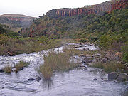
at Delagoa Bay, after a course of some 480 kilometres (298 mi). The Komati Gorge
Komati Gorge
Komati Gorge is a river valley in the Mpumalanga Province in central South Africa, which features vertical sandstone cliffs that provide habitat for a wide diversity of wildlife. Komati Gorge is located near the communities of Carolina and Machadodorp...
is situated in the upper reaches of the Komati River and is the habitat
Habitat
* Habitat , a place where a species lives and grows*Human habitat, a place where humans live, work or play** Space habitat, a space station intended as a permanent settlement...
of some endangered species
Endangered species
An endangered species is a population of organisms which is at risk of becoming extinct because it is either few in numbers, or threatened by changing environmental or predation parameters...
such as the Southern Bald Ibis
Southern Bald Ibis
The Southern Bald Ibis is a large bird found in open grassland or semi-desert in the mountains of southern Africa.This large, glossy, blue-black ibis has an unfeathered red face and head, and a long, decurved red bill. It breeds colonially on and amongst rocks and on cliffs, laying 2-3 eggs which...
. In 2001 the 115m high wall of the Maguga Dam
Maguga Dam
The Maguga Dam is a dam on the Komati River in Swaziland. It is 115 metre's high and is located 11 kilometres south of Piggs Peak. The dam is located at and was completed in 2001....
was completed south of Piggs Peak
Piggs Peak
Piggs Peak is a town in north western Swaziland. It was founded around gold prospecting in 1884, but its main industry is now forestry. The Phophonyane Falls lie near the town. Piggs Peak Casino takes its name from the area...
, Swaziland, 26°4′51.57"S 31°15′25.84"E.
In its upper valley near Steynsdorp are gold-fields, but the reefs consist almost entirely of low grade ore. The river descends the Drakensberg by a pass 30 miles (48.3 km) south of Barberton, and is deflected northward at the eastern border of Swaziland, keeping a course parallel to the Lebombo mountains. Just west of 32°E and 25°25'S, near the town of Komatipoort
Komatipoort
Komatipoort is a town situated at the confluence of the Crocodile and Komati Rivers in Mpumalanga province, South Africa. The town is 8km from the Crocodile Bridge Gate into the Kruger Park, and just 5km from the Mozambique border and 65km from the Swazi border. It is a small, quiet town with some...
, it is joined by the Crocodile River, one of several rivers in South Africa by that name. The Crocodile tributary rises, as the Elands River, in the Bergendal (1,961m) near the upper waters of the Komati, and flows eastwards across the highveld
Highveld
The Highveld is a high plateau region of inland South Africa which is largely home to the largest metropolitan area in the country, the Gauteng City Region, which accounts for one-third of South Africa's population.-Location and description:...
, being turned northward as it reaches the Drakensberg escarpment. The fall to the lowveld
Veld
The term Veld refers primarily to the wide open rural spaces of South Africa or southern Africa and in particular to certain flatter areas or districts covered in grass or low scrub...
is over 600m in 30 miles (48 km), and across the 100 miles (161 km) wide country between the Drakensberg and the Lebombo there is a further fall of 900m.
Just over a kilometre below the junction of the Crocodile, the united stream, which from this point is also known as the Manhissa, passes to the coastal plain through a 190m high cleft, high in the Lebombo known as Komatipoort
Komatipoort
Komatipoort is a town situated at the confluence of the Crocodile and Komati Rivers in Mpumalanga province, South Africa. The town is 8km from the Crocodile Bridge Gate into the Kruger Park, and just 5km from the Mozambique border and 65km from the Swazi border. It is a small, quiet town with some...
, where there are some picturesque falls. At Komatipoort, which marks the frontier between South Africa and Mozambique, the river is less than 60 miles (97 km) from its mouth in a direct line, but in crossing the plain it makes a wide sweep of 200 miles (322 km), first northwards before turning southwards, forming lagoon-like expanses and backwaters and receiving from the north several tributaries. In flood time there is a connection northward through the swamps with the basin of the Limpopo. The Komati enters the sea 15 miles (24 km) north of Maputo. It is navigable from its mouth, where the water is up to 5m deep, to the foot of the Lebombo.
History
The Portuguese named the river's lower reaches the Rio des Reijs, or "river of rice". Subsequently Jan van RiebeeckJan van Riebeeck
Johan Anthoniszoon "Jan" van Riebeeck was a Dutch colonial administrator and founder of Cape Town.-Biography:...
's journal mentions a Rio de Reijs, when he dispatched a ship up the east coast in search of rice supplies. In voortrekker Louis Tregardt
Louis Tregardt
Louis Johannes Tregardt was a farmer from the Cape Colony's eastern frontier, who became an early voortrekker leader. Shunning colonial authority, he emigrated in 1834 to live among the Xhosa, before he crossed the Orange River into neutral territory. His northward trek, along with fellow trekker...
's journal it is referred to as the Manhissa, a name still extant, while to the British it was known as the King George River.
In 1725 a Dutch expedition led by Francois de Kuiper explored the region of the lower Komati and travelled 30km into the current Mpumalanga province, before they were attacked by local tribes and had to return to Delagoa Bay
Maputo Bay
Maputo Bay , formerly Delagoa Bay, Baía da Lagoa is an inlet of the Indian Ocean on the coast of Mozambique, between 25° 40' and 26° 20' S, with a length from north to south of over 90 km long and 32 km wide....
.
On the September 23, 1900 during the Second Boer War
Second Boer War
The Second Boer War was fought from 11 October 1899 until 31 May 1902 between the British Empire and the Afrikaans-speaking Dutch settlers of two independent Boer republics, the South African Republic and the Orange Free State...
, 3,000 Boers crossed the frontier at the small town of Komati Poort, and surrendered to the Portuguese
Portugal
Portugal , officially the Portuguese Republic is a country situated in southwestern Europe on the Iberian Peninsula. Portugal is the westernmost country of Europe, and is bordered by the Atlantic Ocean to the West and South and by Spain to the North and East. The Atlantic archipelagos of the...
authorities. On November 7, 1900 the banks of the Komati became the site of a battle between the British Empire
British Empire
The British Empire comprised the dominions, colonies, protectorates, mandates and other territories ruled or administered by the United Kingdom. It originated with the overseas colonies and trading posts established by England in the late 16th and early 17th centuries. At its height, it was the...
and the Boers. The Battle of Leliefontein
Battle of Leliefontein
The Battle of Leliefontein was an engagement between Canadian/British and Boer forces during the Second Boer War on 7 November 1900, at the Komati River south of Belfast at the present day Nooitgedacht Dam....
was a retreat by the British, harassed by the Boers, who were threatening to capture the British Artillery. The British guns were saved by the Royal Canadian Dragoons who charged the Boers, whereby they placed the guns out of their reach.
Railway
The railway from MaputoMaputo
Maputo, also known as Lourenço Marques, is the capital and largest city of Mozambique. It is known as the City of Acacias in reference to acacia trees commonly found along its avenues and the Pearl of the Indian Ocean. It was famous for the inscription "This is Portugal" on the walkway of its...
to Pretoria
Pretoria
Pretoria is a city located in the northern part of Gauteng Province, South Africa. It is one of the country's three capital cities, serving as the executive and de facto national capital; the others are Cape Town, the legislative capital, and Bloemfontein, the judicial capital.Pretoria is...
traverses the plain in a direct line, and at seventy-two kilometres, reaches the Komati. It follows the south bank of the river and enters the high country at Komati Poort. From the Poort westward the railway skirts the south bank of the Crocodile River
Crocodile River
Crocodile River* Crocodile River , river in the north of South Africa, tributary of Limpopo River* Crocodile River , river in the northeast of South Africa, border river to the south of Kruger National Park...
throughout its length.