

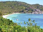
Ko Tao
Encyclopedia
Island
An island or isle is any piece of sub-continental land that is surrounded by water. Very small islands such as emergent land features on atolls can be called islets, cays or keys. An island in a river or lake may be called an eyot , or holm...
in Thailand
Thailand
Thailand , officially the Kingdom of Thailand , formerly known as Siam , is a country located at the centre of the Indochina peninsula and Southeast Asia. It is bordered to the north by Burma and Laos, to the east by Laos and Cambodia, to the south by the Gulf of Thailand and Malaysia, and to the...
located near the western shore of the Gulf of Thailand
Gulf of Thailand
The Gulf of Thailand , also known in to Malays as Teluk Siam literally meant Gulf of Siam, is a shallow arm of the South China Sea.-Geography:...
. It covers an area of about 21 km². Administratively it forms a tambon
Tambon
Tambon is a local government unit in Thailand. Below district and province , they form the third administrative subdivision level. As of the 2009 there are 7255 tambon, not including the 169 khwaeng of Bangkok, which are set at the same administrative level, thus every district contains 8-10 tambon...
within the district (Amphoe
Amphoe
An amphoe is the second level administrative subdivision of Thailand. Usually translated as district, amphoe make up the provinces, and are analogous to a county seat...
) Ko Pha Ngan
Ko Pha Ngan
Ko Pha Ngan is an island in the Gulf of Thailand in South East Thailand. It is famous for its full moon party at Haad Rin Beach and as a backpackers destination. Ko Pha Ngan has two sister islands: the larger Ko Samui to the south and the smaller Ko Tao to the north.* Area: about 168 km²*...
of Surat Thani Province
Surat Thani Province
Surat Thani is the largest of the southern provinces of Thailand, on the eastern shore of the Gulf of Thailand. Surat Thani means City of Good People, the title given to the city by King Vajiravudh ....
. As of 2006 its official population is 1382 . The main settlement is Ban Mae Hat.
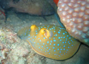
The economy of the island is almost exclusively centered around tourism, especially scuba diving
Scuba diving
Scuba diving is a form of underwater diving in which a diver uses a scuba set to breathe underwater....
.
Ko Tao was named by its first settlers for the island's turtle-like geographic shape. Coincidentally, the island is an important breeding ground for Hawksbill turtle
Hawksbill turtle
The hawksbill sea turtle is a critically endangered sea turtle belonging to the family Cheloniidae. It is the only extant species in its genus. The species has a worldwide distribution, with Atlantic and Pacific subspecies. E. imbricata imbricata is the Atlantic subspecies, while E...
s and Green turtles. Development of tourism has negatively impacted the health of these grounds but a breeding program organised in 2004 by the Royal Thai Navy and KT-DOC, a coalition of local scuba diving centres has reintroduced hundreds of juvenile turtles to the island's ecosystem.
History
Initially the island was not inhabited, there was only the occasional fisherman from the neighboring islands, looking for shelter in a storm or just taking a break before continuing his tiresome journey.It would appear from old maps (1600-1850) and descriptions that this island was known by European cartographers and mariners as "Pulo Bardia". The best example is a map by John Thornton dated 1685. Page 383 of 'The Edinburgh Gazetteer, or Geographical Dictionary' (1822) also mentions the island and provides a geographical position. In his book titled "Narrative of a residence at the capital of the Kingdom of Siam" by Frederick Arthur Neale (1852 p. 120) he describes the people and wildlife of Bardia. According to the account there were farms and even cows in a village on the bay lying to the west side of the island. The book includes a fanciful illustration of 'Bardia' showing huts and palm trees.
On June 18, 1899 King Chulalongkorn
Chulalongkorn
Phra Bat Somdet Phra Poramintharamaha Chulalongkorn Phra Chunla Chom Klao Chao Yu Hua , or Rama V was the fifth monarch of Siam under the House of Chakri. He was known to the Siamese of his time as Phra Phuttha Chao Luang . He is considered one of the greatest kings of Siam...
visited Ko Tao and left as evidence his monogram on a huge boulder at Jor Por Ror bay next to Sairee Beach. This place is still worshiped today.
In 1933 the island started to be used as a political prison. In 1947 Khuang Abhaiwongse
Khuang Abhaiwongse
Major Luang Khuang Abhaiwongse was three times the prime minister of Thailand.Khuang was born in Battambang now belonging to Cambodia as the son of the Siamese governor of the province Battambang, Chao Phraya Abhayabhubet...
, prime minister at that time, pleaded and received a royal pardon for all prisoners on the island. Everybody was taken to the shore of Surat Thani and Ko Tao was abandoned again.
In the same year Khun Uaem and his brother Khun Oh reached Ko Tao from the neighboring Ko Phangan by trying out their traditional sail boat, for that time a quite long and dangerous journey. Even though the island was still under royal patronage, it did not stop these pioneers claiming themselves a good part of the land on today's Sairee beach. Having brought their families over, they began to cultivate and harvest the excellent soil, forming the first generation of the present-day community. They lived a simple and tough life harvesting coconuts, fishing and growing vegetables, which were also traded with Ko Phangan. Despite the difficulties in reaching the island, the population grew steadily.
In the 1980s the first travelers discovered Ko Tao and their special backpacker network quickly made it widely known and a popular destination. As a consequence, bigger, faster and safer boats were used to allow easier access to Ko Tao. In the 1990s the island finally became known as a diving site.
Tourism

Scuba diving
Scuba diving is a form of underwater diving in which a diver uses a scuba set to breathe underwater....
and snorkeling. Also offers some hiking, rock climbing and bouldering. The most popular place for tourists is Sairee on the West coast, which has a white sandy beach of 1.7 km interrupted only by a few huge boulder
Boulder
In geology, a boulder is a rock with grain size of usually no less than 256 mm diameter. While a boulder may be small enough to move or roll manually, others are extremely massive....
s and a scattering of medium budget resorts and restaurants. Chalok Baan Khao, to the south of the island is becoming increasingly popular as an alternative for those wishing to escape the crowds. A multitude of beautiful granite boulders, which nestle both in the forests and on the beaches of Ko Tao, attract a growing number of climbers who visit each year to enjoy the adventurous aspect of their sport.
Ko Tao is less developed than Ko Samui
Ko Samui
Ko Samui island of Surat Thani Province , or often, simply Samui as it is referred to by locals, is an island off the east coast of the Kra Isthmus in Thailand, close to the mainland Surat Thani town. It is Thailand's second largest island, with an area of 228.7 km2 and a population of over...
and Ko Pha Ngan
Ko Pha Ngan
Ko Pha Ngan is an island in the Gulf of Thailand in South East Thailand. It is famous for its full moon party at Haad Rin Beach and as a backpackers destination. Ko Pha Ngan has two sister islands: the larger Ko Samui to the south and the smaller Ko Tao to the north.* Area: about 168 km²*...
, but has become increasingly popular especially with the mid-20's backpacker crowd in search of relatively inexpensive scuba diving certification. For the last two years the demographics of the island has seen an age increase with many of the visitors that first visited the island over ten years ago are now returning with their families.
As of December 2005, Ko Tao had about 150 resorts offering accommodation and approximately 50 bars/clubs. Most of the resorts are still bungalow-style, not hotel/resort style. As of 2007 there is a trend to more upmarket resorts which do not concentrate singularly on diving. Free WiFi is provided in increasing numbers and even the first sailing
Sailing
Sailing is the propulsion of a vehicle and the control of its movement with large foils called sails. By changing the rigging, rudder, and sometimes the keel or centre board, a sailor manages the force of the wind on the sails in order to move the boat relative to its surrounding medium and...
charter company on Ko Tao has opened.
Ko Tao is increasingly becoming a mecca for game fishermen on a budget. Species targeted include marlin, sailfish, king mackerel, cobia, baracuda, trevally and snapper.
Diving conditions have improved dramatically in the past few years with the continuing education of locals by the dive community. The El Nino weather pattern of 1997 caused a warming of the waters which resulted in the loss of a great deal of the shallow corals near the island. Since then, the recovery has been swift and dramatic. And with help by island conservation groups the island environmental outlook is strong.
Chumpon Pinnacle, a dive site to the west of the island has a reputation for divers in search of both whale sharks and bull sharks. However, because of the warmer water temperatures over the last year a great amount of bull sharks have migrated to cooler waters.
Transportation

Ko Tao is serviced by ferry services from Surat Thani
Surat Thani
Surat Thani is a city in Amphoe Mueang Surat Thani, Surat Thani Province, southern Thailand. It is the capital of the province Surat Thani. The city has a population of 128,179 , and an area of 68.97 square kilometers. The city's population density is 1,858.47 inhabitants per km².Suran Thani is...
(4 hours day boat, 9 hours on overnight boat), Chumphon
Chumphon
Chumphon is a town in southern Thailand, capital of the Chumphon Province and the Mueang Chumphon district. The city is located about 463 kilometers away from Bangkok...
(1.5 to 3 hours), Ko Samui
Ko Samui
Ko Samui island of Surat Thani Province , or often, simply Samui as it is referred to by locals, is an island off the east coast of the Kra Isthmus in Thailand, close to the mainland Surat Thani town. It is Thailand's second largest island, with an area of 228.7 km2 and a population of over...
(approx 2.5 hours) and Ko Pha Ngan
Ko Pha Ngan
Ko Pha Ngan is an island in the Gulf of Thailand in South East Thailand. It is famous for its full moon party at Haad Rin Beach and as a backpackers destination. Ko Pha Ngan has two sister islands: the larger Ko Samui to the south and the smaller Ko Tao to the north.* Area: about 168 km²*...
(approx 1 hour). All ferries dock at Ban Mae Haad. Journey times vary due to the different boats used by the various ferry companies. Ticket prices are almost the same for all companies, however, the boats themselves differ greatly. The two main ferries are Lomprayah and Songserm, with Seatran also offering services between the islands and mainland. Lomprayah offer the quickest service on the newest boats, and also have VIP lounges where passengers can watch movies in an air conditioned lounge. In contrast, Songserm is a no-frills point to point fast ferry, where most passengers disembark slightly more green in the face than when they boarded.
Ko Tao has no airport, so anyone wishing to fly would need to fly to Koh Samui Airport
Samui Airport
Samui International Airport , also known as Ko Samui Airport or Koh Samui Airport, is a privately owned airport on the island of Ko Samui in Thailand. The airport is located roughly 2 km north of the main village Chaweng....
and then transfer over on a ferry. Another option for flying down from Bangkok is to fly to Surat Thani Airport
Surat Thani Airport
Surat Thani Airport is situated in the Phunphin district, Surat Thani province, Thailand. The airport, which is located 21 km west of Surat Thani, is also the Wing 7 Airforce base...
, and then catch the boat over after a bus ride of 2 hours to the ferry terminal from the airport. Flights to Surat Thani are much cheaper than flights to Samui, and budget airlines such as Air Asia (and previously Fly-1-2-go who currently aren't flying) service the airport from Bangkok, Chiang Mai, Krabi and Phuket. A flight from Bangkok costs around £30 one way, and a ferry from Surat Thani costs around £5 including coach transfers.
Train services are available from Bangkok down to Chumphon where travellers can then catch a ferry. A first class ticket on an overnight train will cost around £20. Second class tickets are a little cheaper at around £16, passengers do not have the luxury of their own private cabin in second class, however, beds do pull down and once the party is over it is possible to have a good nights sleep. Food is served by train vendors.