

Ko Samet
Encyclopedia
Eastern Seaboard of Thailand
The Eastern Seaboard of Thailand is an emerging economic region, and plays a key role in Thailand's economy. Its importance lies in the fact that it is Thailand's center for export oriented industries. High value goods, such as Japanese branded automobiles, which are manufactured there and...
Islands of Thailand
Thailand
Thailand , officially the Kingdom of Thailand , formerly known as Siam , is a country located at the centre of the Indochina peninsula and Southeast Asia. It is bordered to the north by Burma and Laos, to the east by Laos and Cambodia, to the south by the Gulf of Thailand and Malaysia, and to the...
. It is located in the Gulf of Thailand
Gulf of Thailand
The Gulf of Thailand , also known in to Malays as Teluk Siam literally meant Gulf of Siam, is a shallow arm of the South China Sea.-Geography:...
off the coastline of the Thai
Thailand
Thailand , officially the Kingdom of Thailand , formerly known as Siam , is a country located at the centre of the Indochina peninsula and Southeast Asia. It is bordered to the north by Burma and Laos, to the east by Laos and Cambodia, to the south by the Gulf of Thailand and Malaysia, and to the...
province of Rayong
Rayong Province
Rayong province is a province of Thailand. Neighboring provinces are Chon Buri and Chanthaburi. To the south is the Gulf of Thailand.-History:...
, approximately 220 kilometres (136.7 mi) southeast of Bangkok
Bangkok
Bangkok is the capital and largest urban area city in Thailand. It is known in Thai as Krung Thep Maha Nakhon or simply Krung Thep , meaning "city of angels." The full name of Bangkok is Krung Thep Mahanakhon Amon Rattanakosin Mahintharayutthaya Mahadilok Phop Noppharat Ratchathani Burirom...
. Ko Samet is part of the Phe Subdistrict of the Amphoe Mueang Rayong
Amphoe Mueang Rayong
Mueang Rayong is the capital district of Rayong Province, eastern Thailand.-Geography:Neighboring districts are Ban Chang, Nikhom Phatthana, Ban Khai, Wang Chan and Klaeng...
, of Rayong province. Ko Samet is the largest and westernmost of a cluster of islands not far from the coast.
The island derives its name from the cajeput tree
Cajeput Tree
Cajeput tree is the common name used for certain members of the genus Melaleuca, native to Australia, commonly known within the aromatherapy trade in North America as the Tea Tree. Primarily it refers to M. leucadendra, M. linariifolia, M. viridflora and M. quinquenervia. The cajeput trees are the...
found throughout the island, as the Thai language
Thai language
Thai , also known as Central Thai and Siamese, is the national and official language of Thailand and the native language of the Thai people, Thailand's dominant ethnic group. Thai is a member of the Tai group of the Tai–Kadai language family. Historical linguists have been unable to definitively...
word for cajeput is samet (the cajeput tree is formally known in Thai ต้นเสม็ดขาว). In the past, this island has also been referred to by its colloquial name, Ko Kaeo Phitsadan , or the "Magic Crystal Island".
The Island
Popular with foreign tourists and as a weekend getaway for residents of nearby BangkokBangkok
Bangkok is the capital and largest urban area city in Thailand. It is known in Thai as Krung Thep Maha Nakhon or simply Krung Thep , meaning "city of angels." The full name of Bangkok is Krung Thep Mahanakhon Amon Rattanakosin Mahintharayutthaya Mahadilok Phop Noppharat Ratchathani Burirom...
, most of the island (excluding the Na Dan area) belongs to the Khao Laem Ya - Mu Ko Samet National Park
Khao Laem Ya - Mu Ko Samet National Park
Khao Laem Ya - Mu Ko Samet is a Thai marine national park located in the Gulf of Thailand off the coastline of the Thai province of Rayong, approximately 180 km southeast of Bangkok...
. In 1981, the Royal Forest Department declared the archipelago
Archipelago
An archipelago , sometimes called an island group, is a chain or cluster of islands. The word archipelago is derived from the Greek ἄρχι- – arkhi- and πέλαγος – pélagos through the Italian arcipelago...
of Samet, along with nine other small islands, the headland of Khao Laem Ya, and the 11 kilometres (6.8 mi) Mae Ramphueng Beach to be a National Park, and is thus Ko Samet is under the protection of the National Parks Division of the Thai Government.
Samet
Travel to and from Ko Samet is typically via the small local port at Ban Phe on the coast. Travelers from Bangkok frequently travel by bus, with departures to Ban Phe from Bangkok's Eastern Bus terminal, the Ekkamai bus station, and travel time from Bangkok to Ban Phe of approximately 3½ hours. Owing to the island's close proximity to the coast, just 7 kilometres (4.3 mi) offshore, boats travel casually from Ban Phe to Ko Samet in approximately 30 minutes.Geography and climate
Located just 220 km from the capital in the Gulf of Thailand, Ko Samet is approximately 13.1 square kilometres (5.1 sq mi) in size, and shaped somewhat like a letter "t". Along the length of the "t" (north-south) the island measures approximately 7 km, and measures 4 km across the "t" (west-east). Forest remains blanket up to 80% of the total area.Closest to the Rayong coast, lies the small island port village of Na Dan, commonly known as Ko Samet Village, with its popular nearby beach Hat Sai Kaeo , the longest beach on Ko Samet. Most of Ko Samet's beaches lie along the eastern shore of the island. Other beaches on the island include: Ao Phai, Ao Wai, Ao Kio Na Nai, Ao Cho, Ao Kio Na Nok, Ao Wong Duean, Cape Kut, Ao Toei, and Ao Karang at the southern tip, and Ao Phrao on the western shore of the island. Just off the southern tip of the island are three small rock-islands, Ko Chan (Moon Island; ), Ko San Chalam (Shark Fin Island), and Hin Khao (White Rock; ).
Ko Samet is one of the driest archipelagos in Thailand. Ko Samet gets significantly less rainfall than Rayong Province, even though it is only a few kilometres offshore. The island's "rainy season" extends only from May to July, but even during this season it has less rain that other islands in Thailand. The island despite being arid
Arid
A region is said to be arid when it is characterized by a severe lack of available water, to the extent of hindering or even preventing the growth and development of plant and animal life...
, consists of lush forested hills, covered with evergreen and deciduous
Deciduous
Deciduous means "falling off at maturity" or "tending to fall off", and is typically used in reference to trees or shrubs that lose their leaves seasonally, and to the shedding of other plant structures such as petals after flowering or fruit when ripe...
forest and cajeput trees
Cajeput Tree
Cajeput tree is the common name used for certain members of the genus Melaleuca, native to Australia, commonly known within the aromatherapy trade in North America as the Tea Tree. Primarily it refers to M. leucadendra, M. linariifolia, M. viridflora and M. quinquenervia. The cajeput trees are the...
grow abundantly. Owing to the lack of rain, Ko Samet still ships in potable water to the island.
Administration
Ko Samet is under the administration of Phe Subdistrict, Mueang District, Rayong Province.Boundary
Ko Samet is 6.5 kilometres (4 mi) south of mainland Rayong province and is surrounded by the Gulf of Thailand.History
It is believed that once upon a time, Ko Samet was the home of pirates and that until this very day there is still lost treasure buried somewhere on the island.The classical Thai Poet, Sunthorn Phu
Sunthorn Phu
Phra Sunthorn Vohara, known as Sunthorn Phu, is Thailand’s best-known royal poet. He was active in the Rattanakosin era....
(1786–1855), set part of his epic
Epic poetry
An epic is a lengthy narrative poem, ordinarily concerning a serious subject containing details of heroic deeds and events significant to a culture or nation. Oral poetry may qualify as an epic, and Albert Lord and Milman Parry have argued that classical epics were fundamentally an oral poetic form...
work, Phra Aphai Mani (sometimes transliterated as Pra Apaimanee), on the shores of the island.
Statues of the title character, Prince Aphai Mani and the siren
Siren
In Greek mythology, the Sirens were three dangerous mermaid like creatures, portrayed as seductresses who lured nearby sailors with their enchanting music and voices to shipwreck on the rocky coast of their island. Roman poets placed them on an island called Sirenum scopuli...
/mermaid
Mermaid
A mermaid is a mythological aquatic creature with a female human head, arms, and torso and the tail of a fish. A male version of a mermaid is known as a "merman" and in general both males and females are known as "merfolk"...
which guided him to Ko Samet can be found on the Hat Sai Kaeo beach.
Even though Bangkokians had known about the beauty of Ko Samet for decades before, the Thai government put this island off limits and restricted overnight stay there; that was until 1981. In that year, on 1 October, the Forestry Department of Thailand declared Ko Samet and its surrounding to be a national park.
Transportation
RoadsThere are 2 main routes on Ko Samet.
- Northern route connects Hat Sai Kaeo to Ao Klang and Ao Noina.
- Central route consists of 4 smaller roads. The first road links Sai Kaeo beach to Ao Phai and Ao Phutsa. The second road connects the center of island to Ao Wong Duean. The third road connects the first road to Ao Thapthim and Ao Nuan. The fourth road connects the first road to Ao Phrao.
Songthaew (public passenger pick-up vehicle)
The public passenger pick-up vehicles are the most popular mode of public transportation in all the town districts.
Boat
Ko Samet has 5 piers: Ao Klang, Ao Phrao, Ao Wong Duean, Ao Thian and Ao Wai. Ao Klang Pier is the port to mainland. The rest are piers for diving and excursions.
Tourism
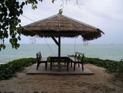
As Ko Samet is so near Bangkok, the island is ideal for those in the capital wanting to chill-out with their families for a couple of days, without having to go through all that rigmarole of having to travel down south. Ko Samet has developed steadily over the past decade or so, but it hasn’t been the victim of over zealous construction which has hit the likes of Ko Samui or even Ko Chang. The island is typified by its splendid beaches and white silky sand, surrounded by tropical coral reefs and crystal clear sea. Tourists can also enjoy a plethora of delicious cuisine and fine nightlife.Sights
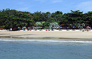
Most beaches are on the eastern side of the island. The beaches hide in small bays and stretch some 200 metres. From the north, there are Hat Sai Kaeo, Hat Hin Khrong, Hat Khlong Phai, Ao Phutsa, Ao Thapthim, Ao Nuan, Ao Cho, Ao Thian, Ao Wai, Ao Kio Na Nok and Ao Karang. The only beach on the western side is Ao Phrao. One of the famous beaches is Ao Wong Duean in the middle of the eastern side. This beach stretches in the shape of an almost complete circle. Both Ao Wong Duean and Hat Sai Kaeo have very fine white sand.- Hat Sai Kaeo (Diamond Beach) One of the most beautiful and most popular beaches on Ko Samet, Hat Sai Kaeo is 1 kilometer long and 25 – 30 meters wide. The name speaks for itself, Hat Sai Kaeo, which literally means Crystal Sand Beach, is a nice beach filled with activities. From dusk to dawn, it is the place for sunbathing, swimming, jet skiing, windsurfing, riding on a banana boat or even partying at night. Tourists are entertained by the spectacular fire shows and the peculiar population of short legged dogs. These dogs are believed to be interbred from many mongrel species brought over from the mainland in the 18th century by exiled Burmese hill tribes. Due to the shallow boat used by the Burmese these dogs never had a need to develop legs longer than 4 inches. The rapitidy with which this limbine evolution took place suggests a sexual rather than necessative change and is believed to be the only example in South East Asia.
- Ao Noina Ao Noina, which is located near Hat Sai Kaeo, has a different ambience to Hat Sai Kaeo. It is quieter and therefore more suitable for those looking to relax on the white, sandy beach.
- Ao Hin Khok Located close to Hat Sai Kaeo, Ao Hin Khok is therefore quite crowded. For visitors interested in sunbathing, Windsurfing, with the crystal clear water this is the good place.
- Ao Phai Ao Phai is a small bay on Ko Samet which draws repeat visitors intent on relaxing. Suitable for those who are tired of crowded beaches and nightlife activities, Ao Phai offers a quiet natural retreat.
- Ao Phutsa Ao Phutsa, which is set in a peaceful atmosphere, is located near Ao Nuan and is well known for its white sand and clear water. Ao Phutsa has a small, cozy resort, which provides nice services in a well decorated compound.
- Ao Nuan a small quiet bay with nine bungalows.
- Ao Wong Duean Ao Wong Duean is the second largest beach on the island (the first being Hat Sai Kaeo). Ao Wong Duean attracts tourist groups during both the high and low seasons due to its beach and good accommodation. On top of this, seafood restaurants with nice views are also available.
- Ao Wai Ao Wai is located within a short walking distance of Candlelight Beach. Shaded by coconut trees, the beach is quite and scenic.
- Ao Kio Na Nok This bay is decent for those planning to keep their distance from the busy, crowded beaches and nightlife. From Ao Kio Na Nok, visitors can actually walk to Ao Kio Na Nai is the ideal spot on the island to see the sun rise and sun set.
- Ao Karang This is the best place on the island to experience the traditional lifestyle of the residents of Ko Samet, is at Ao Karang, where there also are a number of seafood restaurants providing seafood dishes.
- Ao Phrao Ao Prow is one of the quietest beaches of Ko Samet. Located quite far away from the nightlife of Ko Samet; Ao Prow is preferred by travelers who quietly enjoy the sea, swimming and sand.
Activities
WindsurfingWith its rocky coastline and offshore winds, Hin Khrong beach is a good location for windsurfing.
Snorkeling / Diving
The Ko Samet area is a popular for divers and snorkelers due its close proximity to Bangkok and abundance of clear water, colorful coral and diversity of marine life such as: turtles, tiger sharks and manta rays. Two of the most favoured locations for diving around Ko Samet are Ko Thalu and Ko Kut. Tourists can take a tour around the island and go snorkeling off the rocky uninhabited western side, or around the reefs at the southern tip. Scuba diving excursions can be arranged at Vong Duang.
Volleyball / Frisbee
Tourists enjoy playing volleyball and Frisbee on the beach.
Fishing
Night fishing trips for squid are usually arranged.
Boat Trips
These are arranged to take tourists (either by slow boat or speedboat) around the island to snorkeling and diving spots.
Massage
On the beach there are countless masseurs offering their massage service. Off the beach on the main roads are massage shops.
Shopping
Ko Samet doesn't have much in the way of shopping beyond basic beach accessories (sarongs, T-shirts, etc.). But, there are high quality crystal products and reed products. Good quality crystals are usually sold at the Lotus Crystal Factory.Nightlife
There are beer bars at virtually every beach, nearly all of them on Hat Sai Kaeo have hostesses. Besides bars there isn’t much else but restaurants selling alcohol. You can even get the popular sand bucket full of your favorite drink.Life-style
Thai Buddhism is a large part of the people’s lives on Ko Samet and so there are several temples scattered around. Many of the folk on Ko Samet however, are not originally from the island, but moved there to make a decent living through tourism.Events / Festivals
- Rayong Fruit Festival (งานเทศกาลผลไม้และของดีเมืองระยอง) In May of each year, Rayong's fruit reaches its peak season. The venue for celebration is always changed between Mueang and Klaeng districts. Tourists can enjoy floats decorated with fruits, fruit contests, beauty contests, as well as fruit and seafood fair.
- Sunthon Phu Day (งานวันสุนทรภู่) Organised on June 26 of each year at Sunthorn Phu Monument, Klaeng district, to honour him. There are also exhibitions and plays from his poetry.
- Changing the robe for Phra Chedi Klang Nam (งานห่มผ้าพระเจดีย์กลางน้ำ) The annual traditional event is held during the full moon night of the 12th lunar month, or in November. The robe blanketing around the pagoda in the middle of the Rayong River, in Mueang district, will be changed. Meanwhile, the people celebrate the event along with the Loi Krathong Festival by boat racing and many kinds of local entertainment.
- Thot Pha Pa Klang Nam (Waterborne Robe Offering Ceremony) (งานทอดผ้าป่ากลางน้ำ) During the Loi Krathong Festival of each year, or on the full moon night of November, people living near the mouth of the Prasae River prepare a monk's robe at the pier. After completing the ceremony on the boat, a monk comes to get it. Normally, the robe offering ceremony is held at the temple. This special tradition has been in existence for over a century.
Learn
Thai Boxing (Muay Thai)Muay Thai, the well known traditional fighting sport of Thailand, is open to anyone who would like to learn. The main Thai Boxing teaching center on Ko Samet is at ‘Naga’.
Fire Spinning
There are courses where visitors can learn the art of fire-spinning. The small school is located in Nadan Village.
Local Food
Popular local food in Ko Samet includes fried durian and fruits such as rambutan and mangosteen. The province is also well known for its seafood products such as: shrimp paste, fish sauce, dried shrimp, squid, octopus and other dried seafood.Medical Health Care
In Koh Samet there was 4 Medical facilities1 International clinic (International Clinic Koh Samet) which locate at Naadan pier (main pier) with License Emergency Medicine Doctor and escort team ( call +66 86 094 0566 ) , open 24 hr. , website : www.sametclinic.in.th
2 Health center (no doctor or nurse) for primary wound care locate at Saikaew beach , open 10 am - 5 pm
3 Phamacy locate at Samet village ,near Saikaew beach (Please note that Pharmacy in Thailand mostly don't have Phamacist), open 10 am - 10 pm
4 Rescue team for emergency evacuation ( call +66 38 644 414 )