
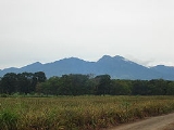
Kitanglad Mountain Range
Encyclopedia
Kitanglad Mountain Range is a mountain range that dominates the northern central portion of the province of Bukidnon
. It occupies portions of eight of the municipalities and cities in the province such as Talakag
, Baungon
, Libona
, Manolo Fortich
, Impasug-ong
, Lantapan
and Malaybalay City
. The range is one of the few remaining rainforests in the Philippines
, hosting one of the most important diverse species of rare and endemic wildlife such as the Philippine Eagle
. Five of its peaks have very high elevations: Mount Dulang-dulang
, the highest at 2,938 meters; Mount Kitanglad
at 2,899 meters; Mount Maagnaw at 2,742 meters; Mount Lumuluyaw at 2,612 meters; and Mount Tuminungan at 2,400 meters.
The name "kitanglad" was derived from a legend that there was once a great flood that submerged the native lands of Bukidnon
and only the tip of the mountain, the size of a "tanglad" (lemon grass), remained visible ("kita" in Cebuano).
The whole range was declared a national park
by virtue of Presidential Proclamation No. 677 on December 4, 1990 known as the Mount Kitanglad Range Natural Park. In 1994, it was chosen as one of the 10 priority sites under the World Bank
through the Conservation of Priority Protected Areas Project. Mount Kitanglad
and its outlying area was proclaimed a protected area under the natural park category through Presidential Proclamation 896 dated October 24, 1996. On November 9, 2000, the park finally became a full-pledge protected area
when Congress approved R.A. 8978 also known as the Mt. Kitanglad Range Protected Area Act of 2000.
province, directly north of the neighboring Kalatungan Mountain Range
. It lies in between 8°7′42″N and 124°55′30″E. It is bounded in the west by Talakag
, northwest by Baungon
, on the north by Libona
and Manolo Fortich
, on the northeast by Impasug-ong
, on the east by Malaybalay City
and on the south by Lantapan
.
Temperature ranges from 22.7°C in January to 24.6 °C in June. It receives the highest amount of rainfall in June. The driest period is March.
, Tagoloan River
, and Pulangi River
, a major tributary of the Rio Grande de Mindanao. Drainage in the area is in a characteristic radial pattern, emanating from the highest points in the range..
Bukidnon
Bukidnon is a landlocked province of the Philippines located in the Northern Mindanao region. Its capital is Malaybalay City. The province borders, clockwise starting from the north, Misamis Oriental, Agusan del Sur, Davao del Norte, Cotabato, Lanao del Sur, and Lanao del Norte.Bukidnon is...
. It occupies portions of eight of the municipalities and cities in the province such as Talakag
Talakag, Bukidnon
Talakag is a 1st class municipality in the province of Bukidnon, Philippines. According to the 2007 census, it has a population of 53,316 people and 8,342 households based on 2000 census.-Origin of Name:...
, Baungon
Baungon, Bukidnon
Baungon is a 2nd class municipality in the northern part of the province of Bukidnon, Philippines. It is about 132 kilometers north of Malaybalay City passing through Cagayan de Oro, which is about 30 kilometers from Imbatug, the towns poblacion. It is bounded on the northeast by the Libona, at the...
, Libona
Libona, Bukidnon
Libona is a 3rd class municipality in the province of Bukidnon, Philippines. According to the 2000 census, it has a population of 35,670 people in 6,459 households.-History of Libona:...
, Manolo Fortich
Manolo Fortich, Bukidnon
Manolo Fortich is a 1st class municipality in the province of Bukidnon, Philippines. According to the 2007 census, it has a population of 82,051 people...
, Impasug-ong
Impasug-Ong, Bukidnon
Impasug-ong is a 1st class municipality in the province of Bukidnon, Philippines. According to the 2000 census, it has a population of 31,173 people in 5,718 households.-Location and General Physical Characteristics:...
, Lantapan
Lantapan, Bukidnon
-Profile of Lantapan:Lantapan is a first class municipality in the province of Bukidnon, Philippines. It used to be a barrio of Malaybalay City until its creation, by virtue of Republic Act No. 4787 enacted on 18 June 1968, as a separate municipality...
and Malaybalay City
Malaybalay City
The City of Malaybalay , dubbed as the "South Summer Capital of the Philippines", is a first class component city and the capital and administrative center of the province of Bukidnon, Philippines...
. The range is one of the few remaining rainforests in the Philippines
Philippines
The Philippines , officially known as the Republic of the Philippines , is a country in Southeast Asia in the western Pacific Ocean. To its north across the Luzon Strait lies Taiwan. West across the South China Sea sits Vietnam...
, hosting one of the most important diverse species of rare and endemic wildlife such as the Philippine Eagle
Philippine Eagle
The Philippine Eagle , also known as the Monkey-eating Eagle, is an eagle of the family Accipitridae that is endemic to forests in the Philippines. It has brown and white-coloured plumage, and a shaggy crest, and generally measures in length and weighs...
. Five of its peaks have very high elevations: Mount Dulang-dulang
Mount Dulang-dulang
Mount Dulang-dulang, dubbed by Filipino mountaineers as "D2", is one of the high elevation peaks in the Kitanglad Mountain Range, located in the north central portion of the province of Bukidnon in the island of Mindanao...
, the highest at 2,938 meters; Mount Kitanglad
Mount Kitanglad
Mount Kitanglad is an inactive volcanic volcano located in the Kitanglad Mountain Range in Bukidnon province on Mindanao island. It is officially declared as the fourth highest mountain in the Philippines and has an approximate height of 2,899 meters...
at 2,899 meters; Mount Maagnaw at 2,742 meters; Mount Lumuluyaw at 2,612 meters; and Mount Tuminungan at 2,400 meters.
The name "kitanglad" was derived from a legend that there was once a great flood that submerged the native lands of Bukidnon
Bukidnon
Bukidnon is a landlocked province of the Philippines located in the Northern Mindanao region. Its capital is Malaybalay City. The province borders, clockwise starting from the north, Misamis Oriental, Agusan del Sur, Davao del Norte, Cotabato, Lanao del Sur, and Lanao del Norte.Bukidnon is...
and only the tip of the mountain, the size of a "tanglad" (lemon grass), remained visible ("kita" in Cebuano).
The whole range was declared a national park
National park
A national park is a reserve of natural, semi-natural, or developed land that a sovereign state declares or owns. Although individual nations designate their own national parks differently A national park is a reserve of natural, semi-natural, or developed land that a sovereign state declares or...
by virtue of Presidential Proclamation No. 677 on December 4, 1990 known as the Mount Kitanglad Range Natural Park. In 1994, it was chosen as one of the 10 priority sites under the World Bank
World Bank
The World Bank is an international financial institution that provides loans to developing countries for capital programmes.The World Bank's official goal is the reduction of poverty...
through the Conservation of Priority Protected Areas Project. Mount Kitanglad
Mount Kitanglad
Mount Kitanglad is an inactive volcanic volcano located in the Kitanglad Mountain Range in Bukidnon province on Mindanao island. It is officially declared as the fourth highest mountain in the Philippines and has an approximate height of 2,899 meters...
and its outlying area was proclaimed a protected area under the natural park category through Presidential Proclamation 896 dated October 24, 1996. On November 9, 2000, the park finally became a full-pledge protected area
Protected area
Protected areas are locations which receive protection because of their recognised natural, ecological and/or cultural values. There are several kinds of protected areas, which vary by level of protection depending on the enabling laws of each country or the regulations of the international...
when Congress approved R.A. 8978 also known as the Mt. Kitanglad Range Protected Area Act of 2000.
Geographical Location
Kitanglad Mountain Range is located in the northern central part of BukidnonBukidnon
Bukidnon is a landlocked province of the Philippines located in the Northern Mindanao region. Its capital is Malaybalay City. The province borders, clockwise starting from the north, Misamis Oriental, Agusan del Sur, Davao del Norte, Cotabato, Lanao del Sur, and Lanao del Norte.Bukidnon is...
province, directly north of the neighboring Kalatungan Mountain Range
Kalatungan Mountain Range
Kalatungan Mountain Range is a mountain range located in the central portion of the province of Bukidnon. It is one of the few areas in the province covered with old growth or mossy forests...
. It lies in between 8°7′42″N and 124°55′30″E. It is bounded in the west by Talakag
Talakag, Bukidnon
Talakag is a 1st class municipality in the province of Bukidnon, Philippines. According to the 2007 census, it has a population of 53,316 people and 8,342 households based on 2000 census.-Origin of Name:...
, northwest by Baungon
Baungon, Bukidnon
Baungon is a 2nd class municipality in the northern part of the province of Bukidnon, Philippines. It is about 132 kilometers north of Malaybalay City passing through Cagayan de Oro, which is about 30 kilometers from Imbatug, the towns poblacion. It is bounded on the northeast by the Libona, at the...
, on the north by Libona
Libona, Bukidnon
Libona is a 3rd class municipality in the province of Bukidnon, Philippines. According to the 2000 census, it has a population of 35,670 people in 6,459 households.-History of Libona:...
and Manolo Fortich
Manolo Fortich, Bukidnon
Manolo Fortich is a 1st class municipality in the province of Bukidnon, Philippines. According to the 2007 census, it has a population of 82,051 people...
, on the northeast by Impasug-ong
Impasug-Ong, Bukidnon
Impasug-ong is a 1st class municipality in the province of Bukidnon, Philippines. According to the 2000 census, it has a population of 31,173 people in 5,718 households.-Location and General Physical Characteristics:...
, on the east by Malaybalay City
Malaybalay City
The City of Malaybalay , dubbed as the "South Summer Capital of the Philippines", is a first class component city and the capital and administrative center of the province of Bukidnon, Philippines...
and on the south by Lantapan
Lantapan, Bukidnon
-Profile of Lantapan:Lantapan is a first class municipality in the province of Bukidnon, Philippines. It used to be a barrio of Malaybalay City until its creation, by virtue of Republic Act No. 4787 enacted on 18 June 1968, as a separate municipality...
.
Climate
The climate at the Kitanglad Ranges falls under the Modified Corona Classification, which is characterized by a short dry season usually lasting from one to three months, and no pronounced rainy season. The area is cloud-covered all year round.Temperature ranges from 22.7°C in January to 24.6 °C in June. It receives the highest amount of rainfall in June. The driest period is March.
Hydrological Features
The Kitanglad Mountain Range forms the headwater catchment area of several major river systems draining north and central Mindanao. Among these rivers are the Cagayan RiverCagayan River (Cagayan de Oro)
Cagayan River, often called as Cagayan de Oro River, is one of the rivers draining the northern central part of the island of Mindanao in the Philippines. The river has its headwaters in the Kalatungan Mountain Range found in the central part of the province of Bukidnon. It traverses the...
, Tagoloan River
Tagoloan River
Tagoloan River is the 13th largest river system in the Philippines in terms of watershed size, as classified by the National Water Resources Board. It has an estimated drainage area of 1,704 square kilometers covering the provinces of Bukidnon and Misamis Oriental. It has a length of 106 kilometers...
, and Pulangi River
Pulangi River
The Pulangi River , also spelled Pulangui, is the longest river in Bukidnon. It is one of the major tributaries of the Rio Grande de Mindanao, an extensive river system in Mindanao, Philippines...
, a major tributary of the Rio Grande de Mindanao. Drainage in the area is in a characteristic radial pattern, emanating from the highest points in the range..