
King's Sedgemoor Drain
Encyclopedia
King's Sedgemoor Drain is an artificial drainage channel
which diverts the River Cary
in Somerset
, England
along the southern flank of the Polden Hills
, to discharge into the River Parrett
at Dunball
near Bridgwater
. As the name suggests, the channel is used to help drain the peat moors of King's Sedgemoor
. There was opposition to drainage schemes from the local inhabitants, who feared that they would lose their common grazing rights. However, the main channel was constructed between 1791 and 1795, and despite some defects, brought some relief from flooding to the area.
The drain was upgraded during the Second World War, to provide a backup water supply for an armaments factory at Puriton
, and again in 1972, when the Sowy River
flood relief channel was built. The drain has hosted the National Fishing Championships, as it is well-stocked with fish, and is also an important haven for birds.
, but with its dissolution
in 1539, the land was divided among owners, with the soil belonging to the Crown. Cornelius Vermuyden
was active in the region in the mid 17th century, building small-scale drainage schemes at Cossington
, Catcott
, Huntspill
and Puriton
, but despite the devastation caused by extensive flooding in 1607
, was unable to convince the communities of Sedgemoor of the benefits that a drainage scheme would bring, as they feared that improved pastures would prejudice their common rights.
King's Sedgemoor was described by Arthur Young in his travelogue of 1771. It was generally flooded, and the water had "no way to get off but by evaporation." Although he felt that its condition was a disgrace to the Nation, he was also convinced that it could be improved by drainage. Drainage schemes were promoted in 1772, 1776 and 1788, and Richard Locke published a map showing what might be achieved in the 1780s. All this came to nothing, as the commoners and some of the manorial lords resisted the plans, while there was well-documented fraud among those proposing the schemes. The 1776 scheme was in reality an attempt by Lord Bolinbroke to raise money to settle a gambling debt. However, a series of Acts of Parliament
were passed between 1777 and 1801, which authorised the construction of drainage schemes in the Somerset moors and levels.
 An Act of 1791 authorised improvements to the drainage of the peat lands of King's Sedgemoor. The existing outfalls for the moor were inadequate. Cowhouse Clyse, near Andersea on the River Parrett, was too high to work well, and Bennett Clyse, a little further downstream, was not working at all. The five commissioners who were appointed under the act proposed a new drainage channel from the area to an existing sluice called Dunball Clyse, and asked William White, a surveyor from Wedmore
near Wells
, to carry out a survey. White found a suitable route, but there were some misgivings, as the area is separated from the coast by a slightly higher ridge of clay, and the scheme involved cutting nearly 2.5 miles (4 km) of drain to a depth of 15 feet (4.6 m) through this ridge, in order to provide the necessary gradient for the water to flow. He was supported in this by John Billingsley
, one of the commissioners who farmed near Sutton Mallet, but who had written a book on the agriculture of Somerset, and the drainage of the levels. He could see no alternative, and so the advice of the engineer William Jessop
was sought. Jessop supported White and Billingsley in his assessment of the options, and so the route was adopted.
The 10.5 miles (16.9 km) channel of the King's Sedgemoor Drain was completed in 1795, running from the River Cary at Henley Corner to Dunball
, to divert the River Cary around the south-western edge of the Polden Hills
. The engineer for the scheme was Robert Anstice, who lived in Bridgwater
and went on to become the first County Surveyor for Somerset. Problems were experienced with new foundations for the sluice at Dunball, which was built on ground which had until 1677 been a meander in the river. White's plans had proposed running the channal further downstream to Nine Streams Reach, but this had been opposed by landowners, and so the clyse was built at Dunball. The unsuitable conditions at Dunball resulted in the clyse being built about 4 feet (1.2 m) too high, and the shallower gradient caused sedimentation in the channels. Earth banks, built from the spoil, caused the underlying peat to rise up in the centre of the drain. A timber floor in the drain was built to restrict this, but the recurrent problem of the peat rising up was not finally solved until the banks were moved further back and in many cases, spread over the adjoining fields.
The scheme included a number of new bridges, with the main ones being at Crandon, Bawdrip, Parchey and Greylake. Penning sluices were fitted to the bridges at Bawdrip and Greylake, to allow the water to be used for irrigation, but in many cases, the bridge openings were too small, with the result that water stacked up behind them in flood conditions. In addition to the main channel, which increased in width from 26.5 to 55 ft (8.1 to 16.8 m) as it approached Dunball, the "Eighteen Feet Rhyne" was built to drain the moor to the north of Henley Corner, and rhynes at Aller, Chedzoy, Shapwick and Street were also 18 feet (5.5 m) wide. Other rhynes were 15 feet (4.6 m) wide. When the scheme was finished, it had cost over £32,000. £15,000 of the total had been spent on engineering work, and the scheme resulted in improvements to the drainage of an area of 11000 acres (4,451.5 ha).
Easton reported that the drain was now nearly useless, and that £10,000 would be needed to put it back into good order. In 1829, he published a proposal to improve the drain so that it would be navigable from Dunball to Yeovil. Drainage required the water levels to be lower, but navigation required them to be higher, and so the scheme came to nothing. The Commissioners scoured the drain, but no real progress was made. In 1842, another report was commissioned, from a Mr. Glyn. His two alternatives were to lower the clyse at Dunball by 4 feet (1.2 m), and to convert the lower part of the channel into a reservoir. Steam engines would be used to pump water into it, and it would empty by gravity at low tide. The Commissioners were unsure whether their powers allowed them to start such work, so they did nothing. In 1844, with the clyse doors in imminent danger of collapse, they paid for the cill to be lowered by 20 inches (50.8 cm) and fitted new doors, but the moors still flooded during most winters.
The Commissioners were replaced following the passing of the Land Drainage Act in 1861. A special commission, which was only responsible for King's Sedgemoor, was created, but like their predecessors, they found that their powers were limited, and their ability to raise funds by rates was inadequate. A high tide in 1876 carried the clyse gates away, and the adjacent bridge had to be demolished for safety. Tides passed up the channel and flooded the moors. Work to construct a new bridge with tidal doors cost £16,000, and the area was impoverished by the debt. The Somerset Drainage Act of 1877 was another attempt to sort out the lack of administrative power, but no work was undertaken in King's Sedgemoor. Serious breaches of the banks occurred in 1872, 1891, 1894, 1924 and 1929.
 The passing of another Land Drainage Act in 1930 held promise for the future. The many bodies responsible for small parts of Somerset's flood defences were swept away, and replaced by the Somerset Catchment Board. More importantly, perhaps, they did not have to prove that benefits would occur to a particular community in order to issue rates for drainage work, but could raise rates based on the rateable values of properties. This shoud have worked, but they soon became apprehensive, and reverted to producing reports, which were not actioned. However, inactivity gave way to action in 1939, when a new engineer was appointed, who saw it as his job to direct what needed to be done. Work began on improvements to the King's Sedgemoor Drain in 1939. The items to be addressed were the size of the channel, the size of the bridges, and the size of Dunball clyse, all of which were too small. The onset of the Second World War, just a few months later, threatened to stop the scheme, but did not.
As part of the war effort, an explosives factory, ROF Bridgwater
, was built at Puriton
. The Catchment Board needed to be able to guarantee that 4.5 million gallons (20.5 Megalitres) of process water would be available to the factory every day. To this end, the Huntspill River was constructed, a little further to the north, which was essentially a revival of a plan by J. Aubrey Clark in 1853, to provide better drainage for the Brue valley
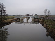
. King's Sedgemoor drain was deemed to be a backup source for water, should the Huntspill scheme fail, and so all of the work which had been planned before the war started was completed, to ensure that the volume of water needed was always available. Greylake sluice was built by the Somerset Rivers Catchment Board in 1942, and used guillotine gates to control water levels. The original plaque commemorating its completion was incorporated into the new structure when the sluice was rebuilt in 2006.
The drain was upgraded in 1972, as part of a £1.4 million scheme to construct a flood relief channel for the River Parrett. The 7.5 miles (12.1 km) embanked channel, called the Sowy River
, runs from Monks Leaze Clyse below Langport
to the King's Sedgemoor Drain near Westonzoyland
Airfield. Improvements to the drain included the relocation and rebuilding of the clyse at Dunball, to create a fresh water seal which prevents salt water from entering the drain where it joins the River Parrett. A further scheme for improvements to the Greylake Sluice was completed at a cost of £2.95 million in 2006, and resulted in the engineering contractor winning the 2006
Environment Agency Project Excellence Awards, for the health and safety and environmental risk aspects of the project. The main features of the new design were two tilting sluice gates, each 13 by contained in a structure which was only half as high as the previous structure, which allow water level management to be controlled in a more flexible manner.
Floodwater is removed from many of the moors of the Somerset Levels by pumping stations, which were originally steam-powered. These were superseded by diesel engines, and more recently by electric pumps. The King's Sedgemoor Drain is unusual in that it operates entirely by gravity. Consideration was given to replacing Dunball clyse with a pumping station in 2002, which would have allowed water to be discharged into the estuary at all states of the tide, but this course of action was not followed. Management of the Drain is the responsibility of the Environment Agency
, whereas the numerous rhynes or drainage ditches which feed into the Drain are the responsibility of several Internal Drainage Board
s, who work together as the Parrett Consortium of Drainage Boards.
-pass was installed at Greylake Sluice, consisting of an open-topped metal channel, fitted with bristles on its base, which allows glass eels returning from the Sargasso Sea
to wiggle their way past the sluice. The channel is equipped with an infra-red camera, to allow the movement of eels to be monitored during the night. The installation, together with a similar one at Oath lock on the River Parrett, has provided valuable information on the migration and decline of eels. The Drain is well stocked with fish, and was used, together with the Huntspill River, as the location for the Division 1 National Fishing Championships in 2008.
At Greylake the Royal Society for the Protection of Birds
have a reserve covering 270 acres (109.3 ha), where birds including curlew
s, lapwing
s, snipe
and redshanks
can be seen in summer, with Bewick's swans, golden plovers
, shovelers
, teals
and wigeon
s arriving in the winter.
was quite different from that of today. It followed part of the route of the present day King's Sedgemoor Drain, forming almost a great loop along the southern flank of the Polden Hills.
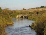
The Drain starts at a narrow sluice at Henley Corner, near Henley, which diverts most of the flow of the River Cary
into it. The old course of the River Cary continues westwards, while the drain heads north-west. Passing under a minor road at Cradle Bridge, it heads to Greylake Bridge, which carries the A361 over it. To the south, the parallel courses of the Langacre Rhyne and Sowy River also cross under the road, as they approach and run beside the Drain. Greylake Sluice is situated immediately after the bridge, and the three drains join about 1 miles (1.6 km) further on near Westonzoyland
Airfield, which was formerly RAF Weston Zoyland
. Just to the north of the bridge is the RSPB reserve, while to the south of the bridge there is an area of Pleistocene Burtle Beds, 22.9 acres (9.3 ha) of which have been a designated Site of Special Scientific Interest
since 1987.
Westonzoyland village is a little further to the west, near where the Battle of Sedgemoor
was fought in 1685. The drain passes close to the village, and then turns to follow a more northerly course, with bridges carrying minor roads at Parchey, with Chedzoy
slightly further west, and at Bawdrip
, which is to the north-east of the Drain. At Crandon Bridge the A39 road
crosses the Drain to a 'T'-junction
with the old course of the A39 to Glastonbury
and the newer A39 spur to the M5 motorway
. Passing to the south of Puriton
, it turns first west and then south-west as it passes under the M5 motorway, the Bristol and Exeter Railway
, and the A38 road
in quick succession, to reach the River Parrett
at Dunball clyse.
Canal
Canals are man-made channels for water. There are two types of canal:#Waterways: navigable transportation canals used for carrying ships and boats shipping goods and conveying people, further subdivided into two kinds:...
which diverts the River Cary
River Cary
The River Cary is a river in Somerset, England.The River Cary has its source at Park Pond in Castle Cary, and then flows southwest through Cary Moor to Babcary, where there is a biological Site of Special Scientific Interest at Babcary Meadows and Cary Fitzpaine. It then flows northwest through...
in Somerset
Somerset
The ceremonial and non-metropolitan county of Somerset in South West England borders Bristol and Gloucestershire to the north, Wiltshire to the east, Dorset to the south-east, and Devon to the south-west. It is partly bounded to the north and west by the Bristol Channel and the estuary of the...
, England
England
England is a country that is part of the United Kingdom. It shares land borders with Scotland to the north and Wales to the west; the Irish Sea is to the north west, the Celtic Sea to the south west, with the North Sea to the east and the English Channel to the south separating it from continental...
along the southern flank of the Polden Hills
Polden Hills
The Polden Hills in Somerset, England are a long, low ridge, extending for , and separated from the Mendip Hills, to which they are nearly parallel, by a marshy tract, known as the Somerset Levels...
, to discharge into the River Parrett
River Parrett
The River Parrett flows through the counties of Dorset and Somerset in South West England, from its source in the Thorney Mills springs in the hills around Chedington in Dorset...
at Dunball
Dunball
Dunball is a small hamlet west of the village of Puriton and close to the town of Bridgwater, Somerset, England.Just north of Dunball is Down End which is the site of Down End Castle a motte-and-bailey castle, which has been designated as a Scheduled Ancient Monument.Located on the A38, adjacent to...
near Bridgwater
Bridgwater
Bridgwater is a market town and civil parish in Somerset, England. It is the administrative centre of the Sedgemoor district, and a major industrial centre. Bridgwater is located on the major communication routes through South West England...
. As the name suggests, the channel is used to help drain the peat moors of King's Sedgemoor
King's Sedgemoor
King's Sedgemoor is a piece of rich animal habit and farming land, that forms part of the Somerset Levels in South West England.The area of King's Sedgemoor fell within the Whitley Hundred,...
. There was opposition to drainage schemes from the local inhabitants, who feared that they would lose their common grazing rights. However, the main channel was constructed between 1791 and 1795, and despite some defects, brought some relief from flooding to the area.
The drain was upgraded during the Second World War, to provide a backup water supply for an armaments factory at Puriton
Puriton
Puriton is a village and a parish, at the westerly end of the Polden Hills, in the Sedgemoor district of Somerset, UK. The parish has a population of 2,124. The local parish church is named after St Michael...
, and again in 1972, when the Sowy River
Sowy River
The Sowy River is an artificial drainage channel in Somerset, England.It is a embanked channel which starts at Monks Leaze clyce below Langport, and carries excess water from the River Parrett to the King's Sedgemoor Drain, from where it flows to the estuary by gravity, rejoining the Parrett near...
flood relief channel was built. The drain has hosted the National Fishing Championships, as it is well-stocked with fish, and is also an important haven for birds.
Background
The area through which the drain runs was farmed as common land when it was owned by the Abbey at GlastonburyGlastonbury Abbey
Glastonbury Abbey was a monastery in Glastonbury, Somerset, England. The ruins are now a grade I listed building, and a Scheduled Ancient Monument and are open as a visitor attraction....
, but with its dissolution
Dissolution of the Monasteries
The Dissolution of the Monasteries, sometimes referred to as the Suppression of the Monasteries, was the set of administrative and legal processes between 1536 and 1541 by which Henry VIII disbanded monasteries, priories, convents and friaries in England, Wales and Ireland; appropriated their...
in 1539, the land was divided among owners, with the soil belonging to the Crown. Cornelius Vermuyden
Cornelius Vermuyden
Sir Cornelius Wasterdyk Vermuyden was a Dutch engineer who introduced Dutch reclamation methods to Britain, and made the first important attempts to drain The Fens of East Anglia.-Life:...
was active in the region in the mid 17th century, building small-scale drainage schemes at Cossington
Cossington, Somerset
Cossington is a village and civil parish close to Woolavington and north of Bridgwater, in the Sedgemoor district in Somerset, England. The village lies on the north side of the Polden Hills.-History:...
, Catcott
Catcott
Catcott is a rural village and civil parish, situated close to Edington to the east of Bridgwater on the Somerset Levels to the north of the Polden Hills in the Sedgemoor district of Somerset, England.-History:...
, Huntspill
Huntspill
West Huntspill and East Huntspill are villages and civil parishes on the Huntspill Level, near Highbridge, Somerset, West of England. The civil parish of West Huntspill contains the hamlet of Alstone, and East Huntspill includes Cote....
and Puriton
Puriton
Puriton is a village and a parish, at the westerly end of the Polden Hills, in the Sedgemoor district of Somerset, UK. The parish has a population of 2,124. The local parish church is named after St Michael...
, but despite the devastation caused by extensive flooding in 1607
Bristol Channel floods, 1607
The Bristol Channel floods, which occurred on 30 January 1607 , resulted in the drowning of a large number of people and the destruction of a large amount of farmland and livestock...
, was unable to convince the communities of Sedgemoor of the benefits that a drainage scheme would bring, as they feared that improved pastures would prejudice their common rights.
King's Sedgemoor was described by Arthur Young in his travelogue of 1771. It was generally flooded, and the water had "no way to get off but by evaporation." Although he felt that its condition was a disgrace to the Nation, he was also convinced that it could be improved by drainage. Drainage schemes were promoted in 1772, 1776 and 1788, and Richard Locke published a map showing what might be achieved in the 1780s. All this came to nothing, as the commoners and some of the manorial lords resisted the plans, while there was well-documented fraud among those proposing the schemes. The 1776 scheme was in reality an attempt by Lord Bolinbroke to raise money to settle a gambling debt. However, a series of Acts of Parliament
Act of Parliament
An Act of Parliament is a statute enacted as primary legislation by a national or sub-national parliament. In the Republic of Ireland the term Act of the Oireachtas is used, and in the United States the term Act of Congress is used.In Commonwealth countries, the term is used both in a narrow...
were passed between 1777 and 1801, which authorised the construction of drainage schemes in the Somerset moors and levels.
Construction
Wedmore
Wedmore is a village and civil parish in the county of Somerset, England. It is situated on raised ground, in the Somerset Levels between the River Axe and River Brue, often called the Isle of Wedmore. It forms part of Sedgemoor district...
near Wells
Wells
Wells is a cathedral city and civil parish in the Mendip district of Somerset, England, on the southern edge of the Mendip Hills. Although the population recorded in the 2001 census is 10,406, it has had city status since 1205...
, to carry out a survey. White found a suitable route, but there were some misgivings, as the area is separated from the coast by a slightly higher ridge of clay, and the scheme involved cutting nearly 2.5 miles (4 km) of drain to a depth of 15 feet (4.6 m) through this ridge, in order to provide the necessary gradient for the water to flow. He was supported in this by John Billingsley
John Billingsley (agriculturist)
John Billingsley was an agricultural pioneer in 18th century Somerset, England.The writer of the 1794 Survey of Somerset, Billingsley was a leading agriculturalist who was one of the founders of the Bath and West Society, known today as the Royal Bath and West of England Society...
, one of the commissioners who farmed near Sutton Mallet, but who had written a book on the agriculture of Somerset, and the drainage of the levels. He could see no alternative, and so the advice of the engineer William Jessop
William Jessop
William Jessop was an English civil engineer, best known for his work on canals, harbours and early railways in the late 18th and early 19th centuries.-Early life:...
was sought. Jessop supported White and Billingsley in his assessment of the options, and so the route was adopted.
The 10.5 miles (16.9 km) channel of the King's Sedgemoor Drain was completed in 1795, running from the River Cary at Henley Corner to Dunball
Dunball
Dunball is a small hamlet west of the village of Puriton and close to the town of Bridgwater, Somerset, England.Just north of Dunball is Down End which is the site of Down End Castle a motte-and-bailey castle, which has been designated as a Scheduled Ancient Monument.Located on the A38, adjacent to...
, to divert the River Cary around the south-western edge of the Polden Hills
Polden Hills
The Polden Hills in Somerset, England are a long, low ridge, extending for , and separated from the Mendip Hills, to which they are nearly parallel, by a marshy tract, known as the Somerset Levels...
. The engineer for the scheme was Robert Anstice, who lived in Bridgwater
Bridgwater
Bridgwater is a market town and civil parish in Somerset, England. It is the administrative centre of the Sedgemoor district, and a major industrial centre. Bridgwater is located on the major communication routes through South West England...
and went on to become the first County Surveyor for Somerset. Problems were experienced with new foundations for the sluice at Dunball, which was built on ground which had until 1677 been a meander in the river. White's plans had proposed running the channal further downstream to Nine Streams Reach, but this had been opposed by landowners, and so the clyse was built at Dunball. The unsuitable conditions at Dunball resulted in the clyse being built about 4 feet (1.2 m) too high, and the shallower gradient caused sedimentation in the channels. Earth banks, built from the spoil, caused the underlying peat to rise up in the centre of the drain. A timber floor in the drain was built to restrict this, but the recurrent problem of the peat rising up was not finally solved until the banks were moved further back and in many cases, spread over the adjoining fields.
The scheme included a number of new bridges, with the main ones being at Crandon, Bawdrip, Parchey and Greylake. Penning sluices were fitted to the bridges at Bawdrip and Greylake, to allow the water to be used for irrigation, but in many cases, the bridge openings were too small, with the result that water stacked up behind them in flood conditions. In addition to the main channel, which increased in width from 26.5 to 55 ft (8.1 to 16.8 m) as it approached Dunball, the "Eighteen Feet Rhyne" was built to drain the moor to the north of Henley Corner, and rhynes at Aller, Chedzoy, Shapwick and Street were also 18 feet (5.5 m) wide. Other rhynes were 15 feet (4.6 m) wide. When the scheme was finished, it had cost over £32,000. £15,000 of the total had been spent on engineering work, and the scheme resulted in improvements to the drainage of an area of 11000 acres (4,451.5 ha).
Maintenance
The next 140 years were marked by an inability to take action on the part of those responsible for the maintenance of the drainage scheme. Once completed, it came under the jurisdiction of the Commissioners of Sewers, and routine maintenance did not take place. In 1811, the Commissioners pinned their hopes on the proposed Bristol to Taunton canal, which would have crossed the drain by an aqueduct, which would have included a new clyse at a lower level than the Dunball outlet, but the canal project came to nothing. The banks continued to slip, and the peak continued to rise up in the bottom of the drain. They asked Robert Anstice to produce a report on the condition of the drain in 1816, but it was 1818 before the report was produced and highlighted the poor state of repair of the system. They also asked for a report on ways to make the bridges wider, but nothing came of it. Ten years later, they commissioned another report, but the local landowners took matters into their own hands and asked Josiah Easton to inspect the drain.Easton reported that the drain was now nearly useless, and that £10,000 would be needed to put it back into good order. In 1829, he published a proposal to improve the drain so that it would be navigable from Dunball to Yeovil. Drainage required the water levels to be lower, but navigation required them to be higher, and so the scheme came to nothing. The Commissioners scoured the drain, but no real progress was made. In 1842, another report was commissioned, from a Mr. Glyn. His two alternatives were to lower the clyse at Dunball by 4 feet (1.2 m), and to convert the lower part of the channel into a reservoir. Steam engines would be used to pump water into it, and it would empty by gravity at low tide. The Commissioners were unsure whether their powers allowed them to start such work, so they did nothing. In 1844, with the clyse doors in imminent danger of collapse, they paid for the cill to be lowered by 20 inches (50.8 cm) and fitted new doors, but the moors still flooded during most winters.
The Commissioners were replaced following the passing of the Land Drainage Act in 1861. A special commission, which was only responsible for King's Sedgemoor, was created, but like their predecessors, they found that their powers were limited, and their ability to raise funds by rates was inadequate. A high tide in 1876 carried the clyse gates away, and the adjacent bridge had to be demolished for safety. Tides passed up the channel and flooded the moors. Work to construct a new bridge with tidal doors cost £16,000, and the area was impoverished by the debt. The Somerset Drainage Act of 1877 was another attempt to sort out the lack of administrative power, but no work was undertaken in King's Sedgemoor. Serious breaches of the banks occurred in 1872, 1891, 1894, 1924 and 1929.
Modern era
As part of the war effort, an explosives factory, ROF Bridgwater
ROF Bridgwater
Royal Ordnance Factory Bridgwater was a factory which produced high explosives for munitions. It was located between the villages of Puriton and Woolavington in the Sedgemoor district of Somerset, UK; but was always known as ROF Bridgwater, after the nearest town...
, was built at Puriton
Puriton
Puriton is a village and a parish, at the westerly end of the Polden Hills, in the Sedgemoor district of Somerset, UK. The parish has a population of 2,124. The local parish church is named after St Michael...
. The Catchment Board needed to be able to guarantee that 4.5 million gallons (20.5 Megalitres) of process water would be available to the factory every day. To this end, the Huntspill River was constructed, a little further to the north, which was essentially a revival of a plan by J. Aubrey Clark in 1853, to provide better drainage for the Brue valley
River Brue
The River Brue originates in the parish of Brewham in Somerset, England, and reaches the sea some 50 km west at Burnham-on-Sea. It originally took a different route from Glastonbury to the sea, but this was changed by the monastery in the twelfth century....
. King's Sedgemoor drain was deemed to be a backup source for water, should the Huntspill scheme fail, and so all of the work which had been planned before the war started was completed, to ensure that the volume of water needed was always available. Greylake sluice was built by the Somerset Rivers Catchment Board in 1942, and used guillotine gates to control water levels. The original plaque commemorating its completion was incorporated into the new structure when the sluice was rebuilt in 2006.
The drain was upgraded in 1972, as part of a £1.4 million scheme to construct a flood relief channel for the River Parrett. The 7.5 miles (12.1 km) embanked channel, called the Sowy River
Sowy River
The Sowy River is an artificial drainage channel in Somerset, England.It is a embanked channel which starts at Monks Leaze clyce below Langport, and carries excess water from the River Parrett to the King's Sedgemoor Drain, from where it flows to the estuary by gravity, rejoining the Parrett near...
, runs from Monks Leaze Clyse below Langport
Langport
Langport is a small town and civil parish in Somerset, England, situated west of Somerton in the South Somerset district. The town has a population of 1,067. The parish includes the hamlets of Bowdens and Combe...
to the King's Sedgemoor Drain near Westonzoyland
Westonzoyland
Westonzoyland is a village and civil parish in Somerset, England. It is situated on the Somerset Levels, south east of Bridgwater.-History:The name of the parish derives from its location on the "island" of Sowy, an area of slightly higher ground on the Somerset Levels between the River Cary and...
Airfield. Improvements to the drain included the relocation and rebuilding of the clyse at Dunball, to create a fresh water seal which prevents salt water from entering the drain where it joins the River Parrett. A further scheme for improvements to the Greylake Sluice was completed at a cost of £2.95 million in 2006, and resulted in the engineering contractor winning the 2006
Environment Agency Project Excellence Awards, for the health and safety and environmental risk aspects of the project. The main features of the new design were two tilting sluice gates, each 13 by contained in a structure which was only half as high as the previous structure, which allow water level management to be controlled in a more flexible manner.
Floodwater is removed from many of the moors of the Somerset Levels by pumping stations, which were originally steam-powered. These were superseded by diesel engines, and more recently by electric pumps. The King's Sedgemoor Drain is unusual in that it operates entirely by gravity. Consideration was given to replacing Dunball clyse with a pumping station in 2002, which would have allowed water to be discharged into the estuary at all states of the tide, but this course of action was not followed. Management of the Drain is the responsibility of the Environment Agency
Environment Agency
The Environment Agency is a British non-departmental public body of the Department for Environment, Food and Rural Affairs and an Assembly Government Sponsored Body of the Welsh Assembly Government that serves England and Wales.-Purpose:...
, whereas the numerous rhynes or drainage ditches which feed into the Drain are the responsibility of several Internal Drainage Board
Internal Drainage Board
An internal drainage board is a type of operating authority which is established in areas of special drainage need in England and Wales with permissive powers to undertake work to secure clean water drainage and water level management within drainage districts...
s, who work together as the Parrett Consortium of Drainage Boards.
Wildlife
In mid-2008, an eelEel
Eels are an order of fish, which consists of four suborders, 20 families, 111 genera and approximately 800 species. Most eels are predators...
-pass was installed at Greylake Sluice, consisting of an open-topped metal channel, fitted with bristles on its base, which allows glass eels returning from the Sargasso Sea
Sargasso Sea
The Sargasso Sea is a region in the middle of the North Atlantic Ocean, surrounded by ocean currents. It is bounded on the west by the Gulf Stream; on the north, by the North Atlantic Current; on the east, by the Canary Current; and on the south, by the North Atlantic Equatorial Current. This...
to wiggle their way past the sluice. The channel is equipped with an infra-red camera, to allow the movement of eels to be monitored during the night. The installation, together with a similar one at Oath lock on the River Parrett, has provided valuable information on the migration and decline of eels. The Drain is well stocked with fish, and was used, together with the Huntspill River, as the location for the Division 1 National Fishing Championships in 2008.
At Greylake the Royal Society for the Protection of Birds
Royal Society for the Protection of Birds
Bird Notes and News was first published in April 1903.The title changed to 'Bird Notes' in 1947. In the 1950s, there were four copies per year . Each volume covered two years, spread over three calendar years...
have a reserve covering 270 acres (109.3 ha), where birds including curlew
Curlew
The curlews , genus Numenius, are a group of eight species of birds, characterised by long, slender, downcurved bills and mottled brown plumage. They are one of the most ancient lineages of scolopacid waders, together with the godwits which look similar but have straight bills...
s, lapwing
Lapwing
Vanellinae are any of various crested plovers, family Charadriidae, noted for its slow, irregular wingbeat in flight and a shrill, wailing cry. Its length is 10-16 inches. They are a subfamily of medium-sized wading birds which also includes the plovers and dotterels. The Vanellinae are...
s, snipe
Snipe
A snipe is any of about 25 wading bird species in three genera in the family Scolopacidae. They are characterized by a very long, slender bill and crypsis plumage. The Gallinago snipes have a nearly worldwide distribution, the Lymnocryptes Jack Snipe is restricted to Asia and Europe and the...
and redshanks
Common Redshank
The Common Redshank or simply Redshank is an Eurasian wader in the large family Scolopacidae.- Description and systematics :...
can be seen in summer, with Bewick's swans, golden plovers
Eurasian Golden Plover
The European Golden Plover is a largish plover. This species is similar to two other golden plovers. American Golden Plover, Pluvialis dominiica, and Pacific Golden Plover, Pluvialis fulva, are both smaller, slimmer and relatively longer-legged than European Golden Plover, and both have grey...
, shovelers
Northern Shoveler
The Northern Shoveler , Northern Shoveller in British English, sometimes known simply as the Shoveler, is a common and widespread duck. It breeds in northern areas of Europe and Asia and across most of North America, and is a rare vagrant to Australia...
, teals
Common Teal
The Eurasian Teal or Common Teal is a common and widespread duck which breeds in temperate Eurasia and migrates south in winter. The Eurasian Teal is often called simply the Teal due to being the only one of these small dabbling ducks in much of its range...
and wigeon
Wigeon
The Eurasian Wigeon, also known as Widgeon or Eurasian Widgeon is one of three species of wigeon in the dabbling duck genus Anas. It is common and widespread within its range...
s arriving in the winter.
Route
In Roman times the course of the River Parrett near PuritonPuriton
Puriton is a village and a parish, at the westerly end of the Polden Hills, in the Sedgemoor district of Somerset, UK. The parish has a population of 2,124. The local parish church is named after St Michael...
was quite different from that of today. It followed part of the route of the present day King's Sedgemoor Drain, forming almost a great loop along the southern flank of the Polden Hills.
The Drain starts at a narrow sluice at Henley Corner, near Henley, which diverts most of the flow of the River Cary
River Cary
The River Cary is a river in Somerset, England.The River Cary has its source at Park Pond in Castle Cary, and then flows southwest through Cary Moor to Babcary, where there is a biological Site of Special Scientific Interest at Babcary Meadows and Cary Fitzpaine. It then flows northwest through...
into it. The old course of the River Cary continues westwards, while the drain heads north-west. Passing under a minor road at Cradle Bridge, it heads to Greylake Bridge, which carries the A361 over it. To the south, the parallel courses of the Langacre Rhyne and Sowy River also cross under the road, as they approach and run beside the Drain. Greylake Sluice is situated immediately after the bridge, and the three drains join about 1 miles (1.6 km) further on near Westonzoyland
Westonzoyland
Westonzoyland is a village and civil parish in Somerset, England. It is situated on the Somerset Levels, south east of Bridgwater.-History:The name of the parish derives from its location on the "island" of Sowy, an area of slightly higher ground on the Somerset Levels between the River Cary and...
Airfield, which was formerly RAF Weston Zoyland
RAF Weston Zoyland
thumb|C-47s of the 306th Troop Carrier SquadronRAF Station Weston Zoyland is a former World War II airfield in Somerset, England. The airfield is located approximately east-southeast of Bridgwater; about west-southwest of London...
. Just to the north of the bridge is the RSPB reserve, while to the south of the bridge there is an area of Pleistocene Burtle Beds, 22.9 acres (9.3 ha) of which have been a designated Site of Special Scientific Interest
Site of Special Scientific Interest
A Site of Special Scientific Interest is a conservation designation denoting a protected area in the United Kingdom. SSSIs are the basic building block of site-based nature conservation legislation and most other legal nature/geological conservation designations in Great Britain are based upon...
since 1987.
Westonzoyland village is a little further to the west, near where the Battle of Sedgemoor
Battle of Sedgemoor
The Battle of Sedgemoor was fought on 6 July 1685 and took place at Westonzoyland near Bridgwater in Somerset, England.It was the final battle of the Monmouth Rebellion and followed a series of skirmishes around south west England between the forces of James Scott, 1st Duke of Monmouth and the...
was fought in 1685. The drain passes close to the village, and then turns to follow a more northerly course, with bridges carrying minor roads at Parchey, with Chedzoy
Chedzoy
Chedzoy is a civil parish village east of Bridgwater in the Sedgemoor district of Somerset, England.-History:The village is at the western end of King's Sedgemoor and lies on an 'island' of Burtle marine sands, close to King's Sedgemoor Drain. The area was settled possibly in the Mesolithic...
slightly further west, and at Bawdrip
Bawdrip
Bawdrip is a village and civil parish in the Sedgemoor district of Somerset, England. The village is on the south side of the Polden Hills about north-east of Bridgwater. According to the 2001 census the parish had a population of 498. The parish includes the hamlets of Bradney and Horsey...
, which is to the north-east of the Drain. At Crandon Bridge the A39 road
A39 road
The A39 is an A road in south west England. It runs south-west from Bath in Somerset through Wells, Glastonbury, Street and Bridgwater. It then follows the north coast of Somerset and Devon through Williton, Minehead, Porlock, Lynmouth, Barnstaple, Bideford, Stratton, Camelford, Wadebridge and St...
crosses the Drain to a 'T'-junction
3-way junction
A 3-way junction is a type of road junction with three arms. A Y junction generally has 3 arms of equal size...
with the old course of the A39 to Glastonbury
Glastonbury
Glastonbury is a small town in Somerset, England, situated at a dry point on the low lying Somerset Levels, south of Bristol. The town, which is in the Mendip district, had a population of 8,784 in the 2001 census...
and the newer A39 spur to the M5 motorway
M5 motorway
The M5 is a motorway in England. It runs from a junction with the M6 at West Bromwich near Birmingham to Exeter in Devon. Heading south-west, the M5 runs east of West Bromwich and west of Birmingham through Sandwell Valley...
. Passing to the south of Puriton
Puriton
Puriton is a village and a parish, at the westerly end of the Polden Hills, in the Sedgemoor district of Somerset, UK. The parish has a population of 2,124. The local parish church is named after St Michael...
, it turns first west and then south-west as it passes under the M5 motorway, the Bristol and Exeter Railway
Bristol and Exeter Railway
The Bristol & Exeter Railway was a railway company formed to connect Bristol and Exeter.The company's head office was situated outside their Bristol station...
, and the A38 road
A38 road
The A38, part of which is also known as the Devon Expressway, is a major A-class trunk road in England.The road runs from Bodmin in Cornwall to Mansfield in Nottinghamshire. It is long, making it one of the longest A-roads in England. It was formerly known as the Leeds — Exeter Trunk Road,...
in quick succession, to reach the River Parrett
River Parrett
The River Parrett flows through the counties of Dorset and Somerset in South West England, from its source in the Thorney Mills springs in the hills around Chedington in Dorset...
at Dunball clyse.