

Kincardine and Deeside
Encyclopedia
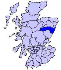
Kincardine and Deeside was formerly (1975-96) a local government district in
the Grampian
Grampian
Grampian was a local government region of Scotland from 1975 to 1996. It is now divided into the unitary council areas of:*Moray*Aberdeenshire*City of AberdeenThe region had five districts:*Aberdeen*Banff and Buchan...
Region of Scotland
Scotland
Scotland is a country that is part of the United Kingdom. Occupying the northern third of the island of Great Britain, it shares a border with England to the south and is bounded by the North Sea to the east, the Atlantic Ocean to the north and west, and the North Channel and Irish Sea to the...
.
In 1996 it was included in the Aberdeenshire unitary area.
History
This region is rich in prehistory with numerous megalithic sites, notable in the earliest period of recorded history with several significant RomanAncient Rome
Ancient Rome was a thriving civilization that grew on the Italian Peninsula as early as the 8th century BC. Located along the Mediterranean Sea and centered on the city of Rome, it expanded to one of the largest empires in the ancient world....
sites. The region is also traversed by several ancient trackway
Trackway
A trackway is an ancient route of travel for people or animals. In biology, a trackway can be a set of impressions in the soft earth, usually a set of footprints, left by an animal. A fossil trackway is the fossilized imprint of a trackway. Trackways have been found all over the world...
s across the Grampian Mounth, including the Causey Mounth
Causey Mounth
The Causey Mounth is an ancient drovers' road over the coastal fringe of the Grampian Mountains in Aberdeenshire, Scotland. This route was developed as the main highway between Stonehaven and Aberdeen around the 12th century AD and it continued to function as the principal route connecting these...
and Elsick Mounth
Elsick Mounth
The Elsick Mounth is an ancient trackway crossing the Grampian Mountains in the vicinity of Netherley, Scotland. This trackway was one of the few means of traversing the Grampian Mounth area in prehistoric and medieval times. The highest pass of the route is attained within the Durris Forest...
. In addition there is evidence of ancient burials from the Beaker Period.
Places of interest
- Dunnottar CastleDunnottar CastleDunnottar Castle is a ruined medieval fortress located upon a rocky headland on the north-east coast of Scotland, about two miles south of Stonehaven. The surviving buildings are largely of the 15th–16th centuries, but the site is believed to have been an early fortress of the Dark Ages...
- FowlsheughFowlsheughFowlsheugh is a coastal nature reserve in Kincardineshire, northeast Scotland, known for its seventy metre high cliff formations and habitat supporting prolific seabird nesting colonies. Designated as a Site of Special Scientific Interest by Scottish Natural Heritage, the property is owned by the...
Nature Reserve - Muchalls CastleMuchalls CastleMuchalls Castle stands overlooking the North Sea in the countryside of Kincardine and Mearns, Aberdeenshire, Scotland. The lower course is a well preserved double groined 13th century towerhouse structure, built by the Frasers of Muchalls. Upon this structure, the 17th century castle was begun by...
- Portlethen MossPortlethen MossThe Portlethen Moss is an acidic bog nature reserve located to the west of the town of Portlethen, Aberdeenshire in Scotland. Like other mosses, this wetland area supports a variety of plant and animal species, even though it has been subject to certain development and agricultural degradation...