
Kimba, South Australia
Encyclopedia
Kimba is a rural service town on the Eyre Highway
at the top of Eyre Peninsula
in South Australia
. At the 2006 census
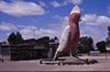
, Kimba had a population of 636 and it has an annual rainfall of 339 mm. There is 7 metre tall statue of a big galah
beside the highway marking halfway between the east and west coasts of Australia
. The Gawler Ranges
are north of the highway near the town.
Kimba is in the District Council of Kimba
, the South Australian Legislative Assembly electoral district of Flinders
and the Australian House of Representatives
Division of Grey
.
The word “Kimba” is derived from the local Aboriginal word for “bushfire”, and the District Council of Kimba's emblem reflects this in the form of a burning bush.
, who passed through the area on his passage from Streaky Bay
to the head of Spencer Gulf
in late 1839.
The area was first settled in the 1870s by lease-holding
pastoralists who moved north up the Eyre Peninsula
during the 1870s and 1880s. They lightly stocked the land and relied on the limited water supplies and intermittent open grass lands to raise their stock. It was more intensively settled for wheat farming from 1908, when overseas demand for wheat increased in the late nineteenth and early twentieth centuries. The large tracts of mallee
scrub began to be cleared to facilitate this, and soon regular mail services were established from the port at Cowell
. Bags of wheat had to be loaded onto bullock drays which carried the produce to Cowell 76 km south.
In 1913, Kimba was connected by narrow gauge railway
to Port Lincoln
. This development encouraged a number of new wheat farmers to move into the area. Two years later the township of Kimba was officially proclaimed and service industries began to move into the district.
Education within the town is Kimba Area School where around 170 students from reception to year 12 attend
Eyre Highway
The Eyre Highway is a highway linking Western Australia and South Australia via the Nullarbor Plain. Signed as National Highway 1/A1, it forms part of Highway 1 and the Australian National Highway network linking Perth and Adelaide. It was named after explorer Edward John Eyre, who was the first to...
at the top of Eyre Peninsula
Eyre Peninsula
Eyre Peninsula is a triangular peninsula in South Australia. It is bounded on the east by Spencer Gulf, the west by the Great Australian Bight, and the north by the Gawler Ranges. It is named after explorer Edward John Eyre who explored some of it in 1839-1841. The coastline was first explored by...
in South Australia
South Australia
South Australia is a state of Australia in the southern central part of the country. It covers some of the most arid parts of the continent; with a total land area of , it is the fourth largest of Australia's six states and two territories.South Australia shares borders with all of the mainland...
. At the 2006 census
Census in Australia
The Australian census is administered once every five years by the Australian Bureau of Statistics. The most recent census was conducted on 9 August 2011; the next will be conducted in 2016. Prior to the introduction of regular censuses in 1961, they had also been run in 1901, 1911, 1921, 1933,...
, Kimba had a population of 636 and it has an annual rainfall of 339 mm. There is 7 metre tall statue of a big galah
Galah
The Galah , Eolophus roseicapilla, also known as the Rose-breasted Cockatoo, Galah Cockatoo, Roseate Cockatoo or Pink and Grey, is one of the most common and widespread cockatoos, and it can be found in open country in almost all parts of mainland Australia.It is endemic on the mainland and was...
beside the highway marking halfway between the east and west coasts of Australia
Australia
Australia , officially the Commonwealth of Australia, is a country in the Southern Hemisphere comprising the mainland of the Australian continent, the island of Tasmania, and numerous smaller islands in the Indian and Pacific Oceans. It is the world's sixth-largest country by total area...
. The Gawler Ranges
Gawler Ranges
The Gawler Ranges are a range of stoney hills in South Australia to the north of Eyre Peninsula. The Eyre Highway skirts the south of the ranges. The Gawler Ranges National Park and Gawler Ranges Conservation Reserve are in the ranges north of Wudinna...
are north of the highway near the town.
Kimba is in the District Council of Kimba
District Council of Kimba
The District Council of Kimba is a local government area located on the northern Eyre Peninsula in South Australia. The district is mostly agricultural in nature, with the township of Kimba being the focal point of the district...
, the South Australian Legislative Assembly electoral district of Flinders
Electoral district of Flinders
Flinders is an electoral district of the House of Assembly in the Australian state of South Australia. It is named after explorer Matthew Flinders, who was responsible for charting most of the state's coastline. It is a 55,260.6 km² coastal rural electorate encompassing the Eyre Peninsula and...
and the Australian House of Representatives
Australian House of Representatives
The House of Representatives is one of the two houses of the Parliament of Australia; it is the lower house; the upper house is the Senate. Members of Parliament serve for terms of approximately three years....
Division of Grey
Division of Grey
The Division of Grey is an Australian Electoral Division in South Australia.The division was created in 1903 and is named for Sir George Grey, who was Governor of South Australia 1841-45 ....
.
The word “Kimba” is derived from the local Aboriginal word for “bushfire”, and the District Council of Kimba's emblem reflects this in the form of a burning bush.
Early history
The first European in the area was explorer Edward John EyreEdward John Eyre
Edward John Eyre was an English land explorer of the Australian continent, colonial administrator, and a controversial Governor of Jamaica....
, who passed through the area on his passage from Streaky Bay
Streaky Bay, South Australia
Streaky Bay is a coastal town on the western side of the Eyre Peninsula, in South Australia just off the Flinders Highway 303 km north west of Port Lincoln and 727 km by road from Adelaide...
to the head of Spencer Gulf
Spencer Gulf
The Spencer Gulf is the westernmost of two large inlets on the southern coast of Australia, in the state of South Australia, facing the Great Australian Bight. The Gulf is 322 km long and 129 km wide at its mouth. The western shore of the Gulf is the Eyre Peninsula, while the eastern side is the...
in late 1839.
The area was first settled in the 1870s by lease-holding
Pastoral lease
A pastoral lease is Crown land that government allows to be leased, generally for the purposes of farming.-Australia:Pastoral leases exist in both Australian commonwealth law and state jurisdictions....
pastoralists who moved north up the Eyre Peninsula
Eyre Peninsula
Eyre Peninsula is a triangular peninsula in South Australia. It is bounded on the east by Spencer Gulf, the west by the Great Australian Bight, and the north by the Gawler Ranges. It is named after explorer Edward John Eyre who explored some of it in 1839-1841. The coastline was first explored by...
during the 1870s and 1880s. They lightly stocked the land and relied on the limited water supplies and intermittent open grass lands to raise their stock. It was more intensively settled for wheat farming from 1908, when overseas demand for wheat increased in the late nineteenth and early twentieth centuries. The large tracts of mallee
Mallee (habit)
Mallee is the growth habit of certain eucalypt species that grow with multiple stems springing from an underground lignotuber, usually to a height of no more than ten metres...
scrub began to be cleared to facilitate this, and soon regular mail services were established from the port at Cowell
Cowell, South Australia
Cowell is a coastal town on Franklin Harbour on the eastern side of the Eyre Peninsula, in South Australia on the Lincoln Highway 111 km south from the major town of Whyalla...
. Bags of wheat had to be loaded onto bullock drays which carried the produce to Cowell 76 km south.
In 1913, Kimba was connected by narrow gauge railway
Eyre Peninsula Railway
The Eyre Peninsula Railway is a railway on the Eyre Peninsula of South Australia. The system is isolated from the rest of the South Australian railway network.- Overview :The network consists of about 600km of route and carries mainly wheat and gypsum...
to Port Lincoln
Port Lincoln, South Australia
- Transport :Port Lincoln is the port for the isolated narrow gauge Eyre Peninsular Railway.There is also a subsidiary port at Proper Bay which may be restored to use for iron ore traffic. The export of iron ore through Port Lincoln has been approved by the South Australian Government. Port...
. This development encouraged a number of new wheat farmers to move into the area. Two years later the township of Kimba was officially proclaimed and service industries began to move into the district.
Education within the town is Kimba Area School where around 170 students from reception to year 12 attend