

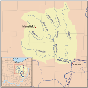
Killbuck Creek
Encyclopedia
Tributary
A tributary or affluent is a stream or river that flows into a main stem river or a lake. A tributary does not flow directly into a sea or ocean...
of the Walhonding River
Walhonding River
The Walhonding River is a principal tributary of the Muskingum River, 23.5 miles long, in east-central Ohio in the United States. Via the Muskingum and Ohio Rivers, it is part of the watershed of the Mississippi River. It drains an area of 2,252 square miles .The Walhonding flows for its entire...
, 81.7 mi (131.5 km) long, in north-central Ohio
Ohio
Ohio is a Midwestern state in the United States. The 34th largest state by area in the U.S.,it is the 7th‑most populous with over 11.5 million residents, containing several major American cities and seven metropolitan areas with populations of 500,000 or more.The state's capital is Columbus...
in the United States
United States
The United States of America is a federal constitutional republic comprising fifty states and a federal district...
. Via the Walhonding, Muskingum
Muskingum River
The Muskingum River is a tributary of the Ohio River, approximately 111 miles long, in southeastern Ohio in the United States. An important commercial route in the 19th century, it flows generally southward through the eastern hill country of Ohio...
and Ohio
Ohio River
The Ohio River is the largest tributary, by volume, of the Mississippi River. At the confluence, the Ohio is even bigger than the Mississippi and, thus, is hydrologically the main stream of the whole river system, including the Allegheny River further upstream...
Rivers, it is part of the watershed
Drainage basin
A drainage basin is an extent or an area of land where surface water from rain and melting snow or ice converges to a single point, usually the exit of the basin, where the waters join another waterbody, such as a river, lake, reservoir, estuary, wetland, sea, or ocean...
of the Mississippi River
Mississippi River
The Mississippi River is the largest river system in North America. Flowing entirely in the United States, this river rises in western Minnesota and meanders slowly southwards for to the Mississippi River Delta at the Gulf of Mexico. With its many tributaries, the Mississippi's watershed drains...
. It drains an area of 613 mi² (1588 km²).
Killbuck Creek rises in northern Wayne County
Wayne County, Ohio
Wayne County is a county located in the state of Ohio, United States, and is named for General "Mad" Anthony Wayne. As of the 2010 census, the population was 114,520. Its county seat is Wooster....
and initially flows in a counter-clockwise loop northward into southern Medina County and past the town of Burbank
Burbank, Ohio
Burbank is a village in Wayne County, Ohio, United States, along Killbuck Creek. The population was 279 at the 2000 census.-Geography:Burbank is located at ....
before turning to a southward course through Wayne, Holmes
Holmes County, Ohio
As of the census of 2000, there were 38,943 people, 11,337 households, and 9,194 families residing in the county. The population density was 92 people per square mile . There were 12,280 housing units at an average density of 29 per square mile...
and Coshocton
Coshocton County, Ohio
Coshocton County is a county located in the state of Ohio, United States. As of the 2010 census, the population was 36,901. Its county seat is Coshocton. Its name comes from the Delaware Indian language and has been translated as "union of waters" or "black bear crossing".The Coshocton...
Counties to its mouth at the Walhonding River, 5 mi (8 km) west of the city of Coshocton
Coshocton, Ohio
Coshocton is a city in and the county seat of Coshocton County, Ohio, United States. The population of the city was 11,682 at the 2000 census. The Walhonding River and the Tuscarawas River meet in Coshocton to form the Muskingum River....
. Along its course it flows to the west of the city of Wooster
Wooster, Ohio
Wooster is a city in the U.S. state of Ohio and the county seat of Wayne County. The municipality is located in northeastern Ohio approximately SSW of Cleveland and SW of Akron. Wooster is noted as the location of The College of Wooster...
and passes the towns of Holmesville
Holmesville, Ohio
Holmesville is a village in Holmes County, Ohio, United States, along Killbuck Creek. The population was 386 at the 2000 census.-Geography:Holmesville is located at ....
, Millersburg
Millersburg, Ohio
Millersburg is a village in Holmes County, Ohio, in the United States. As of the 2000 census, the village population was 3,326. It is the county seat of Holmes County.-Geography:Millersburg is located at , along Killbuck Creek...
and Killbuck
Killbuck, Ohio
Killbuck is a village in Holmes County, Ohio, United States, along Killbuck Creek. The population was 839 at the 2000 census.-Geography:Killbuck is located at ....
.
Name
Killbuck Creek and the town of KillbuckKillbuck, Ohio
Killbuck is a village in Holmes County, Ohio, United States, along Killbuck Creek. The population was 839 at the 2000 census.-Geography:Killbuck is located at ....
are named for the Shawnee
Shawnee
The Shawnee, Shaawanwaki, Shaawanooki and Shaawanowi lenaweeki, are an Algonquian-speaking people native to North America. Historically they inhabited the areas of Ohio, Virginia, West Virginia, Western Maryland, Kentucky, Indiana, and Pennsylvania...
war chief Bemino
Bemino
Bemino — known as John Killbuck, Sr to white settlers — was a renowned medicine man and war leader of Shawnee and Delaware warriors during the French and Indian War . He was a son of Netawatwees, at one time principal chief of the Delaware, and his own son was Gelelemend , a Delaware chief during...
(fl. 1710s–1780s) — known as John Killbuck, Sr, to the whites. According to the Geographic Names Information System
Geographic Names Information System
The Geographic Names Information System is a database that contains name and locative information about more than two million physical and cultural features located throughout the United States of America and its territories. It is a type of gazetteer...
, the stream has been known and spelled variously over the years:
- Kilbuck Creek
- Killbuck Run
- Killbucks Creek
- Kilbuck River
- Kill-Buck River
The United States Board on Geographic Names
United States Board on Geographic Names
The United States Board on Geographic Names is a United States federal body whose purpose is to establish and maintain uniform usage of geographic names throughout the U.S. government.-Overview:...
settled on "Killbuck Creek" as the stream's name in 1963.