

Kewaunee County, Wisconsin
Encyclopedia
Kewaunee County is a county
located in the U.S. state
of Wisconsin
. As of 2000, the population was 20,187. Its county seat
is Kewaunee
. Kewaunee County is part of the Green Bay
Metropolitan Statistical Area
.
, the county has a total area of 1085 square miles (2,810.1 km²), of which 343 square miles (888.4 km²) is land and 742 square miles (1,921.8 km²) (68.41%) is water.

As of the census
of 2000, there were 20,187 people, 7,623 households, and 5,549 families residing in the county. The population density
was 59 people per square mile (23/km²). There were 8,221 housing units at an average density of 24 per square mile (9/km²). The racial makeup of the county was 98.56% White
, 0.15% Black
or African American
, 0.27% Native American
, 0.13% Asian
, 0.30% from other races
, and 0.57% from two or more races. 0.76% of the population were Hispanic
or Latino
of any race. 36.4% were of German, 23.8% Belgian, 9.7% Czech
, 6.3% Polish and 5.1% American
ancestry according to Census 2000.
There were 7,623 households out of which 33.50% had children under the age of 18 living with them, 62.40% were married couples
living together, 6.60% had a female householder with no husband present, and 27.20% were non-families. 23.50% of all households were made up of individuals and 11.80% had someone living alone who was 65 years of age or older. The average household size was 2.61 and the average family size was 3.10.
In the county, the population was spread out with 25.80% under the age of 18, 8.00% from 18 to 24, 28.20% from 25 to 44, 22.80% from 45 to 64, and 15.20% who were 65 years of age or older. The median age was 38 years. For every 100 females there were 100.60 males. For every 100 females age 18 and over, there were 98.80 males.
County (United States)
In the United States, a county is a geographic subdivision of a state , usually assigned some governmental authority. The term "county" is used in 48 of the 50 states; Louisiana is divided into parishes and Alaska into boroughs. Parishes and boroughs are called "county-equivalents" by the U.S...
located in the U.S. state
U.S. state
A U.S. state is any one of the 50 federated states of the United States of America that share sovereignty with the federal government. Because of this shared sovereignty, an American is a citizen both of the federal entity and of his or her state of domicile. Four states use the official title of...
of Wisconsin
Wisconsin
Wisconsin is a U.S. state located in the north-central United States and is part of the Midwest. It is bordered by Minnesota to the west, Iowa to the southwest, Illinois to the south, Lake Michigan to the east, Michigan to the northeast, and Lake Superior to the north. Wisconsin's capital is...
. As of 2000, the population was 20,187. Its county seat
County seat
A county seat is an administrative center, or seat of government, for a county or civil parish. The term is primarily used in the United States....
is Kewaunee
Kewaunee, Wisconsin
Kewaunee is a city in Kewaunee County, Wisconsin, United States. The population was 2,806 at the 2000 census. Located on the northwestern shore of Lake Michigan, the city is the county seat of Kewaunee County....
. Kewaunee County is part of the Green Bay
Green Bay, Wisconsin
Green Bay is a city in and the county seat of Brown County in the U.S. state of Wisconsin, located at the head of Green Bay, a sub-basin of Lake Michigan, at the mouth of the Fox River. It has an elevation of above sea level and is located north of Milwaukee. As of the 2010 United States Census,...
Metropolitan Statistical Area
Green Bay metropolitan area
The Green Bay Metropolitan Statistical Area, as defined by the United States Census Bureau, is an area consisting of three counties in Wisconsin, anchored by the city of Green Bay...
.
Geography
According to the U.S. Census BureauUnited States Census Bureau
The United States Census Bureau is the government agency that is responsible for the United States Census. It also gathers other national demographic and economic data...
, the county has a total area of 1085 square miles (2,810.1 km²), of which 343 square miles (888.4 km²) is land and 742 square miles (1,921.8 km²) (68.41%) is water.
Adjacent counties
- Door CountyDoor County, WisconsinDoor County is a county in the U.S. state of Wisconsin. As of 2000, the population was 27,961. Its county seat is Sturgeon Bay. Door County is a popular vacation and tourist destination, especially for residents of Wisconsin and Illinois....
- north - Manitowoc CountyManitowoc County, WisconsinManitowoc County is a county in the U.S. state of Wisconsin. As of 2000, the population was 82,887. Its county seat is Manitowoc. The United States Census Bureau's Manitowoc Micropolitan Statistical Area includes all of Manitowoc County.-Government:...
- south - Brown County - west
Major highways


Demographics
As of the census
Census
A census is the procedure of systematically acquiring and recording information about the members of a given population. It is a regularly occurring and official count of a particular population. The term is used mostly in connection with national population and housing censuses; other common...
of 2000, there were 20,187 people, 7,623 households, and 5,549 families residing in the county. The population density
Population density
Population density is a measurement of population per unit area or unit volume. It is frequently applied to living organisms, and particularly to humans...
was 59 people per square mile (23/km²). There were 8,221 housing units at an average density of 24 per square mile (9/km²). The racial makeup of the county was 98.56% White
Race (United States Census)
Race and ethnicity in the United States Census, as defined by the Federal Office of Management and Budget and the United States Census Bureau, are self-identification data items in which residents choose the race or races with which they most closely identify, and indicate whether or not they are...
, 0.15% Black
Race (United States Census)
Race and ethnicity in the United States Census, as defined by the Federal Office of Management and Budget and the United States Census Bureau, are self-identification data items in which residents choose the race or races with which they most closely identify, and indicate whether or not they are...
or African American
Race (United States Census)
Race and ethnicity in the United States Census, as defined by the Federal Office of Management and Budget and the United States Census Bureau, are self-identification data items in which residents choose the race or races with which they most closely identify, and indicate whether or not they are...
, 0.27% Native American
Race (United States Census)
Race and ethnicity in the United States Census, as defined by the Federal Office of Management and Budget and the United States Census Bureau, are self-identification data items in which residents choose the race or races with which they most closely identify, and indicate whether or not they are...
, 0.13% Asian
Race (United States Census)
Race and ethnicity in the United States Census, as defined by the Federal Office of Management and Budget and the United States Census Bureau, are self-identification data items in which residents choose the race or races with which they most closely identify, and indicate whether or not they are...
, 0.30% from other races
Race (United States Census)
Race and ethnicity in the United States Census, as defined by the Federal Office of Management and Budget and the United States Census Bureau, are self-identification data items in which residents choose the race or races with which they most closely identify, and indicate whether or not they are...
, and 0.57% from two or more races. 0.76% of the population were Hispanic
Race (United States Census)
Race and ethnicity in the United States Census, as defined by the Federal Office of Management and Budget and the United States Census Bureau, are self-identification data items in which residents choose the race or races with which they most closely identify, and indicate whether or not they are...
or Latino
Race (United States Census)
Race and ethnicity in the United States Census, as defined by the Federal Office of Management and Budget and the United States Census Bureau, are self-identification data items in which residents choose the race or races with which they most closely identify, and indicate whether or not they are...
of any race. 36.4% were of German, 23.8% Belgian, 9.7% Czech
Czech people
Czechs, or Czech people are a western Slavic people of Central Europe, living predominantly in the Czech Republic. Small populations of Czechs also live in Slovakia, Austria, the United States, the United Kingdom, Chile, Argentina, Canada, Germany, Russia and other countries...
, 6.3% Polish and 5.1% American
United States
The United States of America is a federal constitutional republic comprising fifty states and a federal district...
ancestry according to Census 2000.
There were 7,623 households out of which 33.50% had children under the age of 18 living with them, 62.40% were married couples
Marriage
Marriage is a social union or legal contract between people that creates kinship. It is an institution in which interpersonal relationships, usually intimate and sexual, are acknowledged in a variety of ways, depending on the culture or subculture in which it is found...
living together, 6.60% had a female householder with no husband present, and 27.20% were non-families. 23.50% of all households were made up of individuals and 11.80% had someone living alone who was 65 years of age or older. The average household size was 2.61 and the average family size was 3.10.
In the county, the population was spread out with 25.80% under the age of 18, 8.00% from 18 to 24, 28.20% from 25 to 44, 22.80% from 45 to 64, and 15.20% who were 65 years of age or older. The median age was 38 years. For every 100 females there were 100.60 males. For every 100 females age 18 and over, there were 98.80 males.
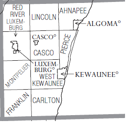
Cities, villages, and towns
- AhnapeeAhnapee, WisconsinAhnapee is a town in Kewaunee County, Wisconsin, United States. The population was 977 as of the 2000 Census. The unincorporated communities of Kodan and Rankin are located in the town.-Geography:...
- AlgomaAlgoma, WisconsinAlgoma is a city in Kewaunee County in the U.S. state of Wisconsin. The population was 3,357 at the 2000 census. Algoma is part of the Green Bay Metropolitan Statistical Area.-Geography:...
- CarltonCarlton, WisconsinCarlton is a town in Kewaunee County, Wisconsin, United States. The population was 1,000 at the 2000 census.-Geography:According to the United States Census Bureau, the town has a total area of 35.6 square miles , all of it land....
- Casco (town)Casco (town), WisconsinCasco is a town in Kewaunee County, Wisconsin, United States. The population was 1,153 at the 2000 census. The village of Casco and the unincorporated communities of Casco Junction, Ryans Corner, and Slovan are located in the town.-Geography:...
- CascoCasco, WisconsinCasco is a village in Kewaunee County, Wisconsin, United States. The population was 572 at the 2000 census. It is part of the Green Bay Metropolitan Statistical Area...
- FranklinFranklin, Kewaunee County, WisconsinFranklin is a town in Kewaunee County, Wisconsin, United States. The population was 997 at the 2000 census. The unincorporated communities of Curran and Stangelville are located in the town.-Geography:...
- KewauneeKewaunee, WisconsinKewaunee is a city in Kewaunee County, Wisconsin, United States. The population was 2,806 at the 2000 census. Located on the northwestern shore of Lake Michigan, the city is the county seat of Kewaunee County....
- LincolnLincoln, Kewaunee County, WisconsinLincoln is a town in Kewaunee County, Wisconsin, United States. The population was 957 at the 2000 census. The unincorporated communities of Lincoln and Rio Creek are located in the town...
- Luxemburg (town)Luxemburg (town), WisconsinLuxemburg is a town in Kewaunee County, Wisconsin, United States. The population was 1,402 at the 2000 census. The unincorporated community of Walhain is located in the town...
- LuxemburgLuxemburg, WisconsinLuxemburg is a village in Kewaunee County, Wisconsin, United States. The population was 1,935 at the 2000 census. It is part of the Green Bay Metropolitan Statistical Area...
- MontpelierMontpelier, WisconsinMontpelier is a town in Kewaunee County, Wisconsin, United States. The population was 1,371 at the 2000 census. The unincorporated communities of Cherneyville, Ellisville, and Pilsen are located in the town.-Geography:...
- PiercePierce, WisconsinPierce is a town in Kewaunee County, Wisconsin, United States. The population was 897 at the 2000 census. The unincorporated communities of Alaska and Rostok are located in the town.-Geography:...
- Red RiverRed River, WisconsinRed River is a town in Kewaunee County, Wisconsin, United States. The population was 1,476 at the 2000 census. The unincorporated communities of Bay View, Duvall, Frog Station, Thiry Daems, and Tonet are located in the town...
- West KewauneeWest Kewaunee, WisconsinWest Kewaunee is a town in Kewaunee County, Wisconsin, United States. The population was 1,287 at the 2000 census. The unincorporated communities of Birchwood, East Krok, and Krok are located in the town.-Geography:...
Unincorporated communities
- AlaskaAlaska, WisconsinAlaska is an unincorporated community located on Wisconsin Highway 42 in the town of Pierce, Kewaunee County, Wisconsin. Alaska falls between East Alaska Lake and West Alaska Lake and is an important tourist, and fishing spot in the region. It is also home to the Alaskan Golf Club a public course...
- Bay ViewBay View, Kewaunee County, WisconsinBay View is an unincorporated community in the town of Red River, Wisconsin, Kewaunee County, Wisconsin, United States....
- BirchwoodBirchwood, Kewaunee County, WisconsinBirchwood is an unincorporated community located in the town of West Kewaunee, Kewaunee County, Wisconsin, United States. Birchwood is located on County Highway F west of Kewaunee....
- Casco JunctionCasco Junction, WisconsinCasco Junction is an unincorporated community located in the town of Casco in Kewaunee County, Wisconsin. The community was an important railroad outpost for the Ahnapee and Western Railway where Casco Junction acted as the southern terminus of the railroad...
- CherneyvilleCherneyville, WisconsinCherneyville is an unincorporated community located in the town of Montpelier, Kewaunee County, Wisconsin, United States. Cherneyville is west of Kewaunee....
- CurranCurran, Kewaunee County, WisconsinCurran is an unincorporated community located in the town of Franklin, Kewaunee County, Wisconsin, United States. Curran is located at the junction of County Highways V and KB east of Denmark....
- DuvallDuvall, WisconsinDuvall is an unincorporated community located in the town of Red River, Kewaunee County, Wisconsin, United States. Duvall is located at the junction of County Highways X and AB north of Luxemburg....
- DyckesvilleDyckesville, WisconsinDyckesville is an unincorporated census-designated place in Brown and Kewaunee counties in the U.S. state of Wisconsin located in the towns of Red River and Green Bay. As of the 2010 census, its population is 538. Dyckesville is bypassed by Wisconsin Highway 57, which ran through the community...
(partial) - East KrokEast Krok, WisconsinEast Krok is an unincorporated community located, in the town of West Kewaunee, in Kewaunee County, Wisconsin. Unincorporated Krok is located just west of East Krok and can be accessed via Krok road.-References:...
- EllisvilleEllisville, WisconsinEllisville is an unincorporated community located in the town of Montpelier, Kewaunee County, Wisconsin, United States. Ellisville is located at the junction of County Highways AB and F south of Luxemburg. The George Halada Farmstead, which is listed on the National Register of Historic Places, is...
- EurenEuren, WisconsinEuren is an unincorporated community located in the town of Lincoln, Kewaunee County, Wisconsin, United States. Euren is located at the junction of County Highways C and S west of Algoma....
- Frog StationFrog Station, WisconsinFrog Station is an unincorporated community in the town of Red River, in Kewaunee County, Wisconsin, United States....
- GregorvilleGregorville, WisconsinGregorville is an unincorporated community located in the town of Lincoln, Kewaunee County, Wisconsin, United States. Gregorville is located at the junction of County Highways P and S west of Algoma....
- KodanKodan, WisconsinKodan is an unincorporated community located in the town of Ahnapee, Kewaunee County, Wisconsin, United States. Kodan is located on County Highway M near its junction with County Highway D, northwest of Algoma....
- KrokKrok, WisconsinKrok is an unincorporated community located in the town of West Kewaunee, in Kewaunee County, Wisconsin. Krok is situated near the origin of the East Twin River and its tributary Krok Creek. Unincorporated Krok is located just west of East Krok and can be accessed via Krok road. In a westward...
- LincolnLincoln (community), WisconsinLincoln is an unincorporated community located in the town of Lincoln, Kewaunee County, Wisconsin, United States. Lincoln is located on County Highway S north-northeast of Luxemburg....
- PilsenPilsen (community), WisconsinPilsen is an unincorporated community, in the town of Montpelier, in Kewaunee County, Wisconsin, United States. It is located on Wisconsin Highway 29.-Notes:...
- RankinRankin, WisconsinRankin is an unincorporated community located, in the town of Ahnapee, in Kewaunee County, Wisconsin. Rankin is positioned along the intersection of Wisconsin Highway 54 and County Highway D, and it is the closest community to Krohns Lake.-References:...
- Rio CreekRio Creek, WisconsinRio Creek is an unincorporated community located off of Wisconsin Highway 54, in the town of Lincoln, in Kewaunee County, Wisconsin. The community is also home to Rio Creek Airport which holds an annual "fly in" with food, camping, and live music....
- RosiereRosiere, WisconsinRosière is an unincorporated community located on the border of Kewaunee County and Door County in Wisconsin, in the towns of Lincoln, and Brussels.-Economy:...
(partial) - RostokRostok, WisconsinRostok is an unincorporated community located in the town of Pierce, Kewaunee County, Wisconsin, United States. Rostok is located on Wisconsin Highway 42 north of Kewaunee....
- Ryans CornerRyans Corner, WisconsinRyans Corner is an unincorporated community located in the town of Casco, in Kewaunee County, Wisconsin, United States. The name was collected by the United States Geological Survey between 1976 and 1980, and entered into the Geographic Names Information System on August 29, 1980.-References:...
- SlovanSlovan, WisconsinSlovan is an unincorporated community located in the town of Casco, Kewaunee County, Wisconsin, United States. Slovan is southeast of the village of Casco....
- StangelvilleStangelville, WisconsinStangelville is an unincorporated community located in the town of Franklin, Kewaunee County, Wisconsin, United States. Stangelville is located at the junction of County Highways AB and J west-southwest of Kewaunee. St. Lawrence Catholic Church, which is listed on the National Register of Historic...
- Thiry DaemsThiry Daems, WisconsinThiry Daems is an unincorporated community located in the town of Red River, Kewaunee County, Wisconsin, United States. Thiry Daems is north of Luxemburg. The community was settled by Belgian immigrants and was named for a surveyor named Constant Thiry and a priest called Father Daems....
- TonetTonet, WisconsinTonet is an unincorporated community located, in the town of Red River, Kewaunee County, Wisconsin, United States. It is located at latitude 44.589 and longitude -87.734; its elevation is 718 feet....
- WalhainWalhain, WisconsinWalhain is an unincorporated community in Kewaunee County, Wisconsin, United States, within the town of Luxemburg. The community is located at the intersection of Walhain Road and Wisconsin Highway 54 about 1 mile east of Luxemburg. It is located at 44.545 latitude and -87.754 longitude at...
See also
- National Register of Historic Places listings in Kewaunee County, Wisconsin
External links
- Kewaunee County
- Northeast Wisconsin Historical County Plat Maps & Atlases University of Wisconsin Digital Collections Center