
.gif)
Highway 57 (Wisconsin)
Encyclopedia
Wisconsin Highway 57 is a 191.82 miles (308.7 km) state highway in the U.S. state
of Wisconsin
. It runs from its southern terminus at Wisconsin Highway 59 in Milwaukee
to its northern terminus at Wisconsin Highway 42 in Sister Bay
. Much of WIS 57 parallels the Interstate 43
corridor, and the highway is concurrent with I-43 for 12 miles (19.3 km) in Ozaukee County. Like most Wisconsin state highways, WIS 57 is maintained by the Wisconsin Department of Transportation
(WisDOT).
WIS 57 serves as a major highway in eastern Wisconsin, and it was originally designed to connect the major cities of Milwaukee and Green Bay
as well as several other large cities along its corridor. The state of Wisconsin proposed that the WIS 57 route become an Interstate Highway corridor when the Interstate Highway System
was planned in the 1950s; the state's plan was rejected in favor of the current routing of Interstate 43. WIS 57 is also a major route to the popular tourist destination of Door County
; it is one of only two state highways to serve the county.
north to Milwaukee along a route that later became U.S. Route 41 and is now Wisconsin Highway 241. By 1921, WIS 57 had been significantly expanded. It was extended northward from Milwaukee to Green Bay
along what is generally its present-day route and southward from Racine to the Illinois
state line. WIS 57 grew even more in 1923, when the state extended the highway northward from Green Bay to the Michigan
state line. However, WIS 57 did not keep this alignment for very long. In 1927, when the U.S. Highway System was established in Wisconsin, WIS 57 was shortened at both ends. The section between Green Bay and Michigan became U.S. Route 141
, and the section south of Milwaukee became part of US 41.
WIS 57 replaced WIS 78 in the Door Peninsula
in 1930, reaching its present-day terminus in Sister Bay. This routing from Milwaukee to Sister Bay stayed mostly the same until the 1990s, with a few minor exceptions. WIS 57 was rerouted onto its current alignment between Hilbert
and Askeaton
in 1932, replacing a former routing to Holland
; the original routing was replaced by county roads. The highway was also realigned between Plymouth
and Kiel
in 1956, and the former route became part of WIS 67.
When the federal government was planning the Interstate Highway System
in the 1950s, Wisconsin proposed that the WIS 57 corridor become the route of an interstate highway. The state wanted an interstate to connect Milwaukee and Green Bay, two of Wisconsin's largest cities. Their plan chose the WIS 57 route over the nearby US 41
and US 141
corridors; the state did not want the interstate's route to favor either the port cities of Manitowoc
and Sheboygan
or the inland cities of Appleton
, Fond du Lac
and Oshkosh
. Wisconsin wanted to designate the highway as Interstate 57 to preserve the highway's number; while this numbering would have fit in the west–east Interstate number scheme, an Interstate 57
was already planned in Illinois
and Missouri
. The state's proposal was ultimately rejected, and Interstate 43
was built on the US 141 corridor along the lakeshore instead.
WisDOT rerouted WIS 57 in south Ozaukee County during the early 1990s in response to local municipalities who complained about heavy traffic on the road. This realignment signed the highway along WIS 167 and Interstate 43
to avoid entering the downtown areas of Mequon
, Thiensville
, Grafton
and Cedarburg
. WIS 57's former routing became a municipal road. This realignment plan also turned WIS 143 over to the county and extended WIS 181 northward from WIS 167 to WIS 60.
A WisDOT project rebuilt and widened the stretch of WIS 57 between WIS 54 and WIS 42, between Sturgeon Bay
and Green Bay
, a primary route to the Door Peninsula
, to four lanes between 1999 and 2008. This section had been a two-lane highway, but traffic during the vacation season caused long delays and made an expansion necessary. The heavy traffic also resulted in the deaths of eighteen people on this section between 1994 and 1997, earning the highway the nickname "Bloody Route 57" among locals. The project began in 1999 when the interchange between WIS 54 and WIS 57 was rebuilt as Phase I of the project. Phase 2 widened WIS 57 to four lanes on the 8 miles (12.9 km) between WIS 54 and Dyckesville
during 2002 and 2003. The first section of four-lane road officially opened on December 2, 2003. WisDOT then began Phase 3 of the project, which widened the rest of the highway through the WIS 42 junction. The first part of this phase, a 6 miles (9.7 km) bypass
of Dyckesville that reached the Door
-Kewaunee
county line, opened on December 1, 2006. The entire project was completed on October 6, 2008, when the last 11 miles (17.7 km) section near Sturgeon Bay
was officially opened.
 Wisconsin Highway 57 has one bannered route, Wisconsin Business Highway 42/57 in Sturgeon Bay
. Business Highway 42/57 is 3.55 miles (5.7 km) long and connects to downtown Sturgeon Bay, which WIS 42 and WIS 57 bypass. It is cosigned as a business route of both WIS 42 and WIS 57 because it splits off of the concurrency of the two highways at both of its ends. Like most auxiliary state highways in Wisconsin, Business Highway 42/57 is locally maintained.
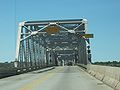
Business Route 42/57 crossed Sturgeon Bay
via the Michigan Street Bridge
, a historic drawbridge near downtown Sturgeon Bay, until September 2008. This bridge was built in 1930 and is 1420 feet (432.8 m) long. The bridge is one of only three crossings of Sturgeon Bay, the others being the WIS 42/WIS 57 bridge and the recently opened Maple and Oregon Streets Bridge. It was placed on the National Register of Historic Places
on January 17, 2008. The bridge was closed to all traffic in July 2008 when structural problems were found in its supports, though it was reopened to light traffic after two days. It was again closed to all traffic when the Maple and Oregon Streets Bridge opened in September 2008, and Business Highway 42/57 was rerouted over this bridge.
U.S. state
A U.S. state is any one of the 50 federated states of the United States of America that share sovereignty with the federal government. Because of this shared sovereignty, an American is a citizen both of the federal entity and of his or her state of domicile. Four states use the official title of...
of Wisconsin
Wisconsin
Wisconsin is a U.S. state located in the north-central United States and is part of the Midwest. It is bordered by Minnesota to the west, Iowa to the southwest, Illinois to the south, Lake Michigan to the east, Michigan to the northeast, and Lake Superior to the north. Wisconsin's capital is...
. It runs from its southern terminus at Wisconsin Highway 59 in Milwaukee
Milwaukee, Wisconsin
Milwaukee is the largest city in the U.S. state of Wisconsin, the 28th most populous city in the United States and 39th most populous region in the United States. It is the county seat of Milwaukee County and is located on the southwestern shore of Lake Michigan. According to 2010 census data, the...
to its northern terminus at Wisconsin Highway 42 in Sister Bay
Sister Bay, Wisconsin
Sister Bay is a village in Door County, Wisconsin, United States. The population was 886 at the 2000 census.-Geography:Sister Bay is located at ....
. Much of WIS 57 parallels the Interstate 43
Interstate 43
Interstate 43 is a intrastate Interstate Highway located entirely within the U.S. state of Wisconsin, connecting Interstate 39 and Interstate 90 in Beloit with Milwaukee and U.S. Route 41 and U.S. Route 141 in Green Bay. I-43 is the 5th longest intrastate Interstate Highway of the Interstate...
corridor, and the highway is concurrent with I-43 for 12 miles (19.3 km) in Ozaukee County. Like most Wisconsin state highways, WIS 57 is maintained by the Wisconsin Department of Transportation
Wisconsin Department of Transportation
The Wisconsin Department of Transportation, abbreviated as WisDOT, is a governmental agency of the U.S. state of Wisconsin responsible for planning, building and maintaining the state's highways...
(WisDOT).
WIS 57 serves as a major highway in eastern Wisconsin, and it was originally designed to connect the major cities of Milwaukee and Green Bay
Green Bay, Wisconsin
Green Bay is a city in and the county seat of Brown County in the U.S. state of Wisconsin, located at the head of Green Bay, a sub-basin of Lake Michigan, at the mouth of the Fox River. It has an elevation of above sea level and is located north of Milwaukee. As of the 2010 United States Census,...
as well as several other large cities along its corridor. The state of Wisconsin proposed that the WIS 57 route become an Interstate Highway corridor when the Interstate Highway System
Interstate Highway System
The Dwight D. Eisenhower National System of Interstate and Defense Highways, , is a network of limited-access roads including freeways, highways, and expressways forming part of the National Highway System of the United States of America...
was planned in the 1950s; the state's plan was rejected in favor of the current routing of Interstate 43. WIS 57 is also a major route to the popular tourist destination of Door County
Door County, Wisconsin
Door County is a county in the U.S. state of Wisconsin. As of 2000, the population was 27,961. Its county seat is Sturgeon Bay. Door County is a popular vacation and tourist destination, especially for residents of Wisconsin and Illinois....
; it is one of only two state highways to serve the county.
History
When the Wisconsin State Highway system was laid out in 1918, WIS 57 ran from RacineRacine, Wisconsin
Racine is a city in and the county seat of Racine County, Wisconsin, United States. According to 2008 U.S. Census Bureau estimates, the city had a population of 82,196...
north to Milwaukee along a route that later became U.S. Route 41 and is now Wisconsin Highway 241. By 1921, WIS 57 had been significantly expanded. It was extended northward from Milwaukee to Green Bay
Green Bay, Wisconsin
Green Bay is a city in and the county seat of Brown County in the U.S. state of Wisconsin, located at the head of Green Bay, a sub-basin of Lake Michigan, at the mouth of the Fox River. It has an elevation of above sea level and is located north of Milwaukee. As of the 2010 United States Census,...
along what is generally its present-day route and southward from Racine to the Illinois
Illinois
Illinois is the fifth-most populous state of the United States of America, and is often noted for being a microcosm of the entire country. With Chicago in the northeast, small industrial cities and great agricultural productivity in central and northern Illinois, and natural resources like coal,...
state line. WIS 57 grew even more in 1923, when the state extended the highway northward from Green Bay to the Michigan
Michigan
Michigan is a U.S. state located in the Great Lakes Region of the United States of America. The name Michigan is the French form of the Ojibwa word mishigamaa, meaning "large water" or "large lake"....
state line. However, WIS 57 did not keep this alignment for very long. In 1927, when the U.S. Highway System was established in Wisconsin, WIS 57 was shortened at both ends. The section between Green Bay and Michigan became U.S. Route 141
U.S. Route 141
U.S. Route 141 is a north–south highway in the U.S. states of Michigan and Wisconsin. US 41 is its parent route. Its northern terminus, on US 41, is near Covington, Michigan; its southern terminus, with I-43 near Bellevue, Wisconsin; it remains in existence in Green Bay, Wisconsin as a...
, and the section south of Milwaukee became part of US 41.
WIS 57 replaced WIS 78 in the Door Peninsula
Door Peninsula
The Door Peninsula is a peninsula in eastern Wisconsin, separating the southern part of the Green Bay from Lake Michigan. The peninsula begins in northern Brown and Kewaunee counties and proceeds northeast to include all of Door County. It is the western portion of the Niagara Escarpment. Well...
in 1930, reaching its present-day terminus in Sister Bay. This routing from Milwaukee to Sister Bay stayed mostly the same until the 1990s, with a few minor exceptions. WIS 57 was rerouted onto its current alignment between Hilbert
Hilbert, Wisconsin
Hilbert is a village in Calumet County in the U.S. state of Wisconsin. The population was 1,089 at the 2000 census.-Geography:Hilbert is located at ....
and Askeaton
Askeaton, Wisconsin
Askeaton is an unincorporated community located in the town of Holland, Brown County, Wisconsin, United States. Askeaton is located along Wisconsin Highway 32 and Wisconsin Highway 57 southeast of Wrightstown....
in 1932, replacing a former routing to Holland
Holland, Wisconsin
Holland, Wisconsin is the name of some places in the U.S. state of Wisconsin:*Holland, Brown County, Wisconsin, a town in Brown County*Holland, La Crosse County, Wisconsin, a town in La Crosse County...
; the original routing was replaced by county roads. The highway was also realigned between Plymouth
Plymouth, Wisconsin
Plymouth is a city in Sheboygan County, Wisconsin, along the Mullet River. The population was 7,781 at the 2000 census. It is included in the Sheboygan, Wisconsin Metropolitan Statistical Area. The city is located within the Town of Plymouth, but is politically independent...
and Kiel
Kiel, Wisconsin
Kiel is a city in Calumet and Manitowoc Counties in the U.S. state of Wisconsin. The population was 3,450 at the 2000 census. The city is located mostly within Manitowoc County, though a portion extends west into adjacent Calumet County....
in 1956, and the former route became part of WIS 67.
When the federal government was planning the Interstate Highway System
Interstate Highway System
The Dwight D. Eisenhower National System of Interstate and Defense Highways, , is a network of limited-access roads including freeways, highways, and expressways forming part of the National Highway System of the United States of America...
in the 1950s, Wisconsin proposed that the WIS 57 corridor become the route of an interstate highway. The state wanted an interstate to connect Milwaukee and Green Bay, two of Wisconsin's largest cities. Their plan chose the WIS 57 route over the nearby US 41
U.S. Route 41
U.S. Route 41 is a north–south United States Highway that runs from Miami, Florida to the Upper Peninsula of Michigan. Until 1949, the part in southern Florida, from Naples to Miami, was U.S...
and US 141
U.S. Route 141
U.S. Route 141 is a north–south highway in the U.S. states of Michigan and Wisconsin. US 41 is its parent route. Its northern terminus, on US 41, is near Covington, Michigan; its southern terminus, with I-43 near Bellevue, Wisconsin; it remains in existence in Green Bay, Wisconsin as a...
corridors; the state did not want the interstate's route to favor either the port cities of Manitowoc
Manitowoc, Wisconsin
Manitowoc is a city in and the county seat of Manitowoc County, Wisconsin, United States. The city is located on Lake Michigan at the mouth of the Manitowoc River. According to the 2000 census, Manitowoc had a population of 34,053, with over 50,000 residents in the surrounding communities...
and Sheboygan
Sheboygan, Wisconsin
-Airport:Sheboygan is served by the Sheboygan County Memorial Airport, which is located several miles from the city.-Roads:Interstate 43 is the primary north-south transportation route into Sheboygan, and forms the west boundary of the city. U.S...
or the inland cities of Appleton
Appleton, Wisconsin
Appleton is a city in Outagamie, Calumet, and Winnebago Counties in the U.S. state of Wisconsin. It is situated on the Fox River, 30 miles southwest of Green Bay and 100 miles north of Milwaukee. Appleton is the county seat of Outagamie County. The population was 78,086 at the 2010 census...
, Fond du Lac
Fond du Lac, Wisconsin
Fond du Lac is a city in Fond du Lac County, Wisconsin, United States. The name is French for bottom of the lake, for it is located at the bottom of Lake Winnebago. The population was 42,203 at the 2000 census...
and Oshkosh
Oshkosh, Wisconsin
As of the census of 2000, there were 62,916 people, 24,082 households, and 13,654 families residing in the city. The population density was 2,662.2 people per square mile . There were 25,420 housing units at an average density of 1,075.6 per square mile...
. Wisconsin wanted to designate the highway as Interstate 57 to preserve the highway's number; while this numbering would have fit in the west–east Interstate number scheme, an Interstate 57
Interstate 57
Interstate 57 is an Interstate Highway in Missouri and Illinois that parallels the old Illinois Central rail line for much of its route. It goes from Miner, Missouri, at Interstate 55 to Chicago, Illinois, at Interstate 94. I-57 essentially serves as a shortcut route for travelers headed between...
was already planned in Illinois
Illinois
Illinois is the fifth-most populous state of the United States of America, and is often noted for being a microcosm of the entire country. With Chicago in the northeast, small industrial cities and great agricultural productivity in central and northern Illinois, and natural resources like coal,...
and Missouri
Missouri
Missouri is a US state located in the Midwestern United States, bordered by Iowa, Illinois, Kentucky, Tennessee, Arkansas, Oklahoma, Kansas and Nebraska. With a 2010 population of 5,988,927, Missouri is the 18th most populous state in the nation and the fifth most populous in the Midwest. It...
. The state's proposal was ultimately rejected, and Interstate 43
Interstate 43
Interstate 43 is a intrastate Interstate Highway located entirely within the U.S. state of Wisconsin, connecting Interstate 39 and Interstate 90 in Beloit with Milwaukee and U.S. Route 41 and U.S. Route 141 in Green Bay. I-43 is the 5th longest intrastate Interstate Highway of the Interstate...
was built on the US 141 corridor along the lakeshore instead.
WisDOT rerouted WIS 57 in south Ozaukee County during the early 1990s in response to local municipalities who complained about heavy traffic on the road. This realignment signed the highway along WIS 167 and Interstate 43
Interstate 43
Interstate 43 is a intrastate Interstate Highway located entirely within the U.S. state of Wisconsin, connecting Interstate 39 and Interstate 90 in Beloit with Milwaukee and U.S. Route 41 and U.S. Route 141 in Green Bay. I-43 is the 5th longest intrastate Interstate Highway of the Interstate...
to avoid entering the downtown areas of Mequon
Mequon, Wisconsin
Mequon is a city in Ozaukee County, Wisconsin, United States. It had a population of 21,823 at the 2000 census, and an estimated population of 23,739 in July 2009...
, Thiensville
Thiensville, Wisconsin
Thiensville is a village in Ozaukee County, Wisconsin, United States. The population was 3,254 at the 2000 census. It was founded by its namesake, John Henry Thien....
, Grafton
Grafton, Wisconsin
Grafton is a village in Ozaukee County, Wisconsin, United States. The population was 10,312 at the 2000 census. The village is adjacent to the Town of Grafton and the City of Cedarburg.-History:...
and Cedarburg
Cedarburg, Wisconsin
Cedarburg is a city in Ozaukee County, Wisconsin, United States with Cedar Creek running through it. The city is bordered by the Village of Grafton to the east and the Town of Cedarburg elsewhere...
. WIS 57's former routing became a municipal road. This realignment plan also turned WIS 143 over to the county and extended WIS 181 northward from WIS 167 to WIS 60.
A WisDOT project rebuilt and widened the stretch of WIS 57 between WIS 54 and WIS 42, between Sturgeon Bay
Sturgeon Bay, Wisconsin
Sturgeon Bay is a city in and the county seat of Door County, Wisconsin, United States. The population was 9,437 at the 2000 census. It is located at the natural end of Sturgeon Bay, although the Sturgeon Bay Ship Canal was built across the remainder of the Door Peninsula.-Geography:Sturgeon Bay is...
and Green Bay
Green Bay, Wisconsin
Green Bay is a city in and the county seat of Brown County in the U.S. state of Wisconsin, located at the head of Green Bay, a sub-basin of Lake Michigan, at the mouth of the Fox River. It has an elevation of above sea level and is located north of Milwaukee. As of the 2010 United States Census,...
, a primary route to the Door Peninsula
Door Peninsula
The Door Peninsula is a peninsula in eastern Wisconsin, separating the southern part of the Green Bay from Lake Michigan. The peninsula begins in northern Brown and Kewaunee counties and proceeds northeast to include all of Door County. It is the western portion of the Niagara Escarpment. Well...
, to four lanes between 1999 and 2008. This section had been a two-lane highway, but traffic during the vacation season caused long delays and made an expansion necessary. The heavy traffic also resulted in the deaths of eighteen people on this section between 1994 and 1997, earning the highway the nickname "Bloody Route 57" among locals. The project began in 1999 when the interchange between WIS 54 and WIS 57 was rebuilt as Phase I of the project. Phase 2 widened WIS 57 to four lanes on the 8 miles (12.9 km) between WIS 54 and Dyckesville
Dyckesville, Wisconsin
Dyckesville is an unincorporated census-designated place in Brown and Kewaunee counties in the U.S. state of Wisconsin located in the towns of Red River and Green Bay. As of the 2010 census, its population is 538. Dyckesville is bypassed by Wisconsin Highway 57, which ran through the community...
during 2002 and 2003. The first section of four-lane road officially opened on December 2, 2003. WisDOT then began Phase 3 of the project, which widened the rest of the highway through the WIS 42 junction. The first part of this phase, a 6 miles (9.7 km) bypass
Bypass (road)
A bypass is a road or highway that avoids or "bypasses" a built-up area, town, or village, to let through traffic flow without interference from local traffic, to reduce congestion in the built-up area, and to improve road safety....
of Dyckesville that reached the Door
Door County, Wisconsin
Door County is a county in the U.S. state of Wisconsin. As of 2000, the population was 27,961. Its county seat is Sturgeon Bay. Door County is a popular vacation and tourist destination, especially for residents of Wisconsin and Illinois....
-Kewaunee
Kewaunee County, Wisconsin
Kewaunee County is a county located in the U.S. state of Wisconsin. As of 2000, the population was 20,187. Its county seat is Kewaunee. Kewaunee County is part of the Green Bay Metropolitan Statistical Area.-Geography:According to the U.S...
county line, opened on December 1, 2006. The entire project was completed on October 6, 2008, when the last 11 miles (17.7 km) section near Sturgeon Bay
Sturgeon Bay, Wisconsin
Sturgeon Bay is a city in and the county seat of Door County, Wisconsin, United States. The population was 9,437 at the 2000 census. It is located at the natural end of Sturgeon Bay, although the Sturgeon Bay Ship Canal was built across the remainder of the Door Peninsula.-Geography:Sturgeon Bay is...
was officially opened.
Bannered routes
Sturgeon Bay, Wisconsin
Sturgeon Bay is a city in and the county seat of Door County, Wisconsin, United States. The population was 9,437 at the 2000 census. It is located at the natural end of Sturgeon Bay, although the Sturgeon Bay Ship Canal was built across the remainder of the Door Peninsula.-Geography:Sturgeon Bay is...
. Business Highway 42/57 is 3.55 miles (5.7 km) long and connects to downtown Sturgeon Bay, which WIS 42 and WIS 57 bypass. It is cosigned as a business route of both WIS 42 and WIS 57 because it splits off of the concurrency of the two highways at both of its ends. Like most auxiliary state highways in Wisconsin, Business Highway 42/57 is locally maintained.
Business Route 42/57 crossed Sturgeon Bay
Sturgeon Bay
Sturgeon Bay is an arm of Green Bay extending southeastward approximately 10 miles into the Door Peninsula at the city of Sturgeon Bay, located approximately halfway up the Door Peninsula. The bay is connected to Lake Michigan by the Sturgeon Bay Ship Canal. Three bridges cross the bay, including...
via the Michigan Street Bridge
Sturgeon Bay Bridge
The Sturgeon Bay Bridge is a historic bridge in Sturgeon Bay, Wisconsin, United States. The bridge was built in 1930 and carried Michigan Street, which was signed as Wisconsin Business Highway 42/57. The Sturgeon Bay Bridge was listed on the National Register of Historic Places on January 17, 2008...
, a historic drawbridge near downtown Sturgeon Bay, until September 2008. This bridge was built in 1930 and is 1420 feet (432.8 m) long. The bridge is one of only three crossings of Sturgeon Bay, the others being the WIS 42/WIS 57 bridge and the recently opened Maple and Oregon Streets Bridge. It was placed on the National Register of Historic Places
National Register of Historic Places
The National Register of Historic Places is the United States government's official list of districts, sites, buildings, structures, and objects deemed worthy of preservation...
on January 17, 2008. The bridge was closed to all traffic in July 2008 when structural problems were found in its supports, though it was reopened to light traffic after two days. It was again closed to all traffic when the Maple and Oregon Streets Bridge opened in September 2008, and Business Highway 42/57 was rerouted over this bridge.
Major intersections
| County | Location | Mile | Junction | Notes |
|---|---|---|---|---|
| Milwaukee | Milwaukee Milwaukee, Wisconsin Milwaukee is the largest city in the U.S. state of Wisconsin, the 28th most populous city in the United States and 39th most populous region in the United States. It is the county seat of Milwaukee County and is located on the southwestern shore of Lake Michigan. According to 2010 census data, the... |
0.0 | ||
| 0.8 | Access to Interstate 94 is via St. Paul Avenue | |||
| 1.5 | Begin concurrency with US 18 | |||
| 2.2 | End concurrency with US 18 | |||
| 3.1 | Begin concurrency with WIS 145 | |||
| 3.4 | End concurrency with WIS 145 | |||
| 5.4 | Begin concurrency with WIS 190 | |||
| 6.2 | End concurrency with WIS 190 | |||
| 6.3 | Access to southbound I-43 only; the northbound entrance ramp can be accessed via WIS 190 and 7th St. | |||
| Brown Deer Brown Deer, Wisconsin Brown Deer is a village in Milwaukee County, Wisconsin, United States. It is a suburb of Milwaukee. The population was 11,999 at the 2010 census... |
13.0 | |||
| Ozaukee | Thiensville Thiensville, Wisconsin Thiensville is a village in Ozaukee County, Wisconsin, United States. The population was 3,254 at the 2000 census. It was founded by its namesake, John Henry Thien.... |
16.2 | Begin concurrency with WIS 167 | |
| 19.3 | Begin concurrency with I-43 and WIS 32; end concurrency with WIS 167 | |||
| Ulao Ulao, Wisconsin Ulao, Wisconsin, is an unincorporated community in the Town of Grafton in Ozaukee County, Wisconsin. It is located at the intersection of Ulao Road and the old Chicago and Northwestern railroad running from Milwaukee to Green Bay. Today, I-43 runs a few hundred feet to the west of the town... |
26.2 | |||
| Grafton Grafton, Wisconsin Grafton is a village in Ozaukee County, Wisconsin, United States. The population was 10,312 at the 2000 census. The village is adjacent to the Town of Grafton and the City of Cedarburg.-History:... |
27.6 | End concurrency with WIS 32 | ||
| Saukville Saukville, Wisconsin -External links:* *... |
30.7 | |||
| 31.5 | End concurrency with I-43 | |||
| Sheboygan | Random Lake Random Lake, Wisconsin Random Lake is a village in Sheboygan County, Wisconsin, United States. The population was 1,551 at the 2000 census. It is part of the Sheboygan, Wisconsin Metropolitan Statistical Area.-Geography:Random Lake is located at .... |
43.3 | ||
| Waldo Waldo, Wisconsin Waldo is a village in Sheboygan County, Wisconsin, United States, along the Onion River. The population was 450 at the 2000 census. It is included in the Sheboygan, Wisconsin Metropolitan Statistical Area.-History:... |
50.9 | Begin concurrency with WIS 28 | ||
| 51.4 | End concurrency with WIS 28 | |||
| Plymouth Plymouth, Wisconsin Plymouth is a city in Sheboygan County, Wisconsin, along the Mullet River. The population was 7,781 at the 2000 census. It is included in the Sheboygan, Wisconsin Metropolitan Statistical Area. The city is located within the Town of Plymouth, but is politically independent... |
56.6 | |||
| Manitowoc Manitowoc County, Wisconsin Manitowoc County is a county in the U.S. state of Wisconsin. As of 2000, the population was 82,887. Its county seat is Manitowoc. The United States Census Bureau's Manitowoc Micropolitan Statistical Area includes all of Manitowoc County.-Government:... |
Millhome Millhome, Wisconsin Millhome is an unincorporated community in the town of Schleswig, Manitowoc County, Wisconsin, United States. The nearest city to Millhome is Kiel. The community is located just west of the intersection of Wisconsin Highway 32 and Wisconsin Highway 57 and is along the border between Manitowoc and... |
66.2 | Begin concurrency with WIS 32 | |
| Kiel Kiel, Wisconsin Kiel is a city in Calumet and Manitowoc Counties in the U.S. state of Wisconsin. The population was 3,450 at the 2000 census. The city is located mostly within Manitowoc County, though a portion extends west into adjacent Calumet County.... |
69.8 | |||
| Calumet Calumet County, Wisconsin Calumet County is a county located in the U.S. state of Wisconsin. It is included in the Appleton, Wisconsin, Metropolitan Statistical Area. As of 2010, the county's population was 48,971. The county seat is Chilton.-History:... |
Chilton Chilton, Wisconsin Chilton is a city in and county seat of Calumet County in the U.S. state of Wisconsin. The population was 3,708 at the 2000 census. The city is located partially within the Town of Chilton.-History:... |
81.0 | Begin concurrency with US 151 | |
| 81.8 | End concurrency with US 151 | |||
| Hilbert Hilbert, Wisconsin Hilbert is a village in Calumet County in the U.S. state of Wisconsin. The population was 1,089 at the 2000 census.-Geography:Hilbert is located at .... |
89.4 | |||
| Forest Junction Forest Junction, Wisconsin Forest Junction is an unincorporated census-designated place in the Town of Brillion, in Calumet County, Wisconsin in the United States. As of the 2010 census, its population was 616.The community has its own water tower and utilities. Its ZIP code is 54123.... |
94.5 | |||
| Brown | Greenleaf Greenleaf, Wisconsin Greenleaf, Wisconsin is an unincorporated census-designated place in Brown County, Wisconsin, in the town of Wrightstown. It is located at the intersection of Wisconsin Highways 57/32 and 96. It uses ZIP code 54126. As of the 2010 census, Greenleaf has a population of 607... |
102.3 | ||
| De Pere De Pere, Wisconsin De Pere is a city located in Brown County, Wisconsin, United States. The population was 20,559 at the 2000 census. De Pere is a suburb of Green Bay and is part of the Green Bay Metropolitan Statistical Area.-Registered historic places:... |
112.1 | End of concurrency with WIS 32 | ||
| Allouez Allouez, Wisconsin Allouez is a village in Brown County in the U.S. state of Wisconsin. As of the 2000 census, the village population was 15,443. It is part of the Green Bay Metropolitan Statistical Area.-Geography:... |
114.4 | |||
| Green Bay Green Bay, Wisconsin Green Bay is a city in and the county seat of Brown County in the U.S. state of Wisconsin, located at the head of Green Bay, a sub-basin of Lake Michigan, at the mouth of the Fox River. It has an elevation of above sea level and is located north of Milwaukee. As of the 2010 United States Census,... |
116.9 | Beginning of concurrency with WIS 54 | ||
| 117.4 | Beginning of concurrency with WIS 29 | |||
| 117.7 | End of concurrency with WIS 29 | |||
| 120.6 | ||||
| 125.1 | ||||
| Door Door County, Wisconsin Door County is a county in the U.S. state of Wisconsin. As of 2000, the population was 27,961. Its county seat is Sturgeon Bay. Door County is a popular vacation and tourist destination, especially for residents of Wisconsin and Illinois.... |
Maplewood Maplewood, Wisconsin Maplewood is an unincorporated community in Door County, in the town of Forestville, Wisconsin, United States. The nearest city to Maplewood is Sturgeon Bay. Maplewood is located along Wisconsin Highway 42 approximately 3 miles south of its junction with Wisconsin Highway 57.... |
154.1 | Begin concurrency with WIS 42 | |
| Sturgeon Bay Sturgeon Bay, Wisconsin Sturgeon Bay is a city in and the county seat of Door County, Wisconsin, United States. The population was 9,437 at the 2000 census. It is located at the natural end of Sturgeon Bay, although the Sturgeon Bay Ship Canal was built across the remainder of the Door Peninsula.-Geography:Sturgeon Bay is... |
159.1 | |||
| 163.5 | ||||
| 164.9 | End concurrency with WIS 42 | |||
| Sister Bay Sister Bay, Wisconsin Sister Bay is a village in Door County, Wisconsin, United States. The population was 886 at the 2000 census.-Geography:Sister Bay is located at .... |
191.82 |