

Kew East, Victoria
Encyclopedia
Kew East is a suburb in Melbourne
, Victoria
, Australia
, 9 km east from Melbourne's central business district
. Its Local Government Area is the City of Boroondara
. At the 2006 Census, Kew East had a population of 6140.
The Wills family established "Willsmere Estate" a grazing and dairying property, the name now reflected in Willsmere Road and Willsmere Park.
William Wade established a farm named "Belford" next door. A flood in December 1863 devastated the property, which later became the Kew Golf Course.
The Harp of Erin Hotel on the corner of Harp Road and High Street was established in 1854 by Edward Glynn. It was a centre for race meetings and gave its name to Harp Road which was part of a route to Lilydale
used by Cobb and Co.
Kew East Post Office opened around 1924.
The East Kew Maternal and Child Health Centre in Strathalbyn Street, Kew East is registered as a Historic Place with Heritage Victoria. Opened in December 1925, it is the earliest purpose-built and intact baby health centre in the state.
; to the north by the Yarra River
and to the west by the Yarra River, parts of Kilby and Willsmere Roads and the property boundaries between Willsmere Road and Rattan Avenue. The southern boundary follows Carnegie Avenue, Park Crescent, Earl Street, Asquith Street, property boundaries near Belford Road (south), High Street and Harp Road. The Eastern Freeway runs across the centre of the suburb from east to west.
, a secondary college located on Burke Road
and Kew East Primary School on Kitchener Street. St Annes Catholic School is located on Beresford Street.
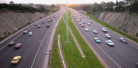 The Eastern Freeway is accessible via the Chandler Highway
or Burke Road. The Main Yarra Trail
, a shared bicycle and pedestrian path, runs along the north side of the freeway. Belford Road bridges the freeway, providing a link to the northern part of the suburb. The suburb has a single tram line along High Street which accommodates tram route 24
and 48
.
There are a number of bus routes which connect the suburb to surrounding areas.
Melbourne
Melbourne is the capital and most populous city in the state of Victoria, and the second most populous city in Australia. The Melbourne City Centre is the hub of the greater metropolitan area and the Census statistical division—of which "Melbourne" is the common name. As of June 2009, the greater...
, Victoria
Victoria (Australia)
Victoria is the second most populous state in Australia. Geographically the smallest mainland state, Victoria is bordered by New South Wales, South Australia, and Tasmania on Boundary Islet to the north, west and south respectively....
, Australia
Australia
Australia , officially the Commonwealth of Australia, is a country in the Southern Hemisphere comprising the mainland of the Australian continent, the island of Tasmania, and numerous smaller islands in the Indian and Pacific Oceans. It is the world's sixth-largest country by total area...
, 9 km east from Melbourne's central business district
Melbourne city centre
Melbourne City Centre is an area of Melbourne in Victoria, Australia. It is not to be confused with the larger local government area of the City of Melbourne...
. Its Local Government Area is the City of Boroondara
City of Boroondara
The City of Boroondara is a Local Government Area in Victoria, Australia. It is located in the eastern suburbs of Melbourne.This area was originally occupied by the Wurundjeri, Indigenous Australians of the Kulin nation....
. At the 2006 Census, Kew East had a population of 6140.
History
A number of farming properties were established along the Yarra River following government land auctions between 1845 and 1847.The Wills family established "Willsmere Estate" a grazing and dairying property, the name now reflected in Willsmere Road and Willsmere Park.
William Wade established a farm named "Belford" next door. A flood in December 1863 devastated the property, which later became the Kew Golf Course.
The Harp of Erin Hotel on the corner of Harp Road and High Street was established in 1854 by Edward Glynn. It was a centre for race meetings and gave its name to Harp Road which was part of a route to Lilydale
Lilydale, Victoria
Lilydale is a suburb of Melbourne, Victoria, Australia, 35 km north-east from Melbourne's central business district situated in the Olinda Creek valley. At the 2006 Census, Lilydale had a population of 13,887...
used by Cobb and Co.
Kew East Post Office opened around 1924.
The East Kew Maternal and Child Health Centre in Strathalbyn Street, Kew East is registered as a Historic Place with Heritage Victoria. Opened in December 1925, it is the earliest purpose-built and intact baby health centre in the state.
Street names
Windella Road was originally named Balfour Road, after Kew resident and politician James Balfour. It was renamed to Windella Avenue, after Balfour's residence Windella, due to the similarity of the former name to that of nearby Belford Road. Longstaff, Leason, McCubbin, Newbury, Fraser and Lister Streets are all named after Australian painters.Geography
The suburb is bounded to the to the east by Burke RoadBurke Road, Melbourne
Burke Road is a major north-south thoroughfare in Melbourne, Australia. It runs from Ivanhoe to Caulfield, and includes the major shopping district at Camberwell...
; to the north by the Yarra River
Yarra River
The Yarra River, originally Birrarung, is a river in east-central Victoria, Australia. The lower stretches of the river is where the city of Melbourne was established in 1835 and today Greater Melbourne dominates and influences the landscape of its lower reaches...
and to the west by the Yarra River, parts of Kilby and Willsmere Roads and the property boundaries between Willsmere Road and Rattan Avenue. The southern boundary follows Carnegie Avenue, Park Crescent, Earl Street, Asquith Street, property boundaries near Belford Road (south), High Street and Harp Road. The Eastern Freeway runs across the centre of the suburb from east to west.
Education
There are two co-educational government schools located in Kew East — Kew High SchoolKew High School
Kew High School is a co-educational school in suburban Melbourne, Victoria, Australia, for students in years 7–12. It has over 1,400 students from the neighbourhoods of Kew, Balwyn, Ivanhoe, East Ivanhoe, Alphington, Rosanna, Clifton Hill, Richmond, Abbotsford, Hawthorn and Bundoora, with waiting...
, a secondary college located on Burke Road
Burke Road, Melbourne
Burke Road is a major north-south thoroughfare in Melbourne, Australia. It runs from Ivanhoe to Caulfield, and includes the major shopping district at Camberwell...
and Kew East Primary School on Kitchener Street. St Annes Catholic School is located on Beresford Street.
Sport and recreation
Kew Golf Club and Green Acres Golf Club on Elm Grove are located in the north of the suburb and Balwyn Judo Clubhttp://www.judobalwyn.org.au in the east. Parks in Kew East include Willsmere-Chandler Park, home of the suburb's only sport team East Kew United Soccer Club, and the adjacent Kew Billabong, Hays Paddock on Glass Creek, Hyde Park, Harrison Park and Stradbroke Park.Shopping
The main shopping area, "Harp Village", is located on High Street near the intersection with Harp Road. A small local centre, Belford Court Shopping Centre, is located on Belford Road.Transport
Chandler Highway
Chandler Highway is a short road in the inner eastern suburbs of Melbourne. It runs from Heidelberg Road in Alphington, across the Yarra River, using a narrow two-lane bridge over the Yarra River, then continues across the Eastern Freeway, then terminates at an intersection with Princess Street and...
or Burke Road. The Main Yarra Trail
Main Yarra Trail
The Yarra Trail is a shared use path for cyclists and pedestrians, which follows the Yarra River through the north eastern suburbs of Melbourne, Victoria, Australia....
, a shared bicycle and pedestrian path, runs along the north side of the freeway. Belford Road bridges the freeway, providing a link to the northern part of the suburb. The suburb has a single tram line along High Street which accommodates tram route 24
Melbourne tram route 24
Tram route 24 is a public transport service in Melbourne, Victoria, Australia, which runs from La Trobe Street in the city centre, to North Balwyn. Like most tram routes in Melbourne, it falls within Metcard ticketing Zone 1....
and 48
Melbourne tram route 48
Tram route 48 is a public transport service in Melbourne, Victoria, Australia. It runs from Victoria Harbour, Docklands to North Balwyn via Collins Street, Spring Street, Wellington Parade and Bridge Road...
.
There are a number of bus routes which connect the suburb to surrounding areas.
Places of worship
Places of worship include:- St Paul's Anglican Church, located on the corner of Windella Avenue and Hale Street
- East Kew Uniting Church, Normanby Road
- MWP Centre, Westbrook Street
- St Anne's Catholic Church, Windellla Avenue
- The Leo Baeck Centre for Progressive Judaism, Harp Road