
Kettleshulme
Encyclopedia
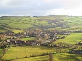
Kettleshulme is a small village and civil parish in the unitary authority of Cheshire East
and the ceremonial county of Cheshire
, England
. The village is close to the border with Derbyshire
, on the B5470 road
(Macclesfield Road) from Whaley Bridge
to Macclesfield
, in the valley of the Todd Brook
, a tributary of the River Goyt between Sponds Hill and Taxal Edge. The civil parish has a population of around 353 people.
limestone
and the Derbyshire, Cheshire shale
and gritstone
. The original settlement mainly consisted of a mixture of limestone and sandstone buildings, including the old Church, built in the 19th century out of limestone quarried near the town of Buxton
, around 7 miles away. At 1000 ft above sea level, Kettleshulme is relatively high up which makes the weather colder at times, but its location and climate make the land very suitable for farming. The nearest weather station in Buxton recorded that the area has a mean temperature on average since 1969 up to the present day of 7.8.C and average rainfall per year of 1286 mm.
countryside, it is only around 13 miles away from the centre of Manchester
, and a 40 minute drive from the city airport. This makes it popular for business people to live here and commute to the city or the airport. There is a bus service that starts in Disley and goes through Kettleshulme to Macclesfield and back five times a day. The nearest railway is at Whaley Bridge railway station
on the
Manchester-Buxton line
wick material, but this ceased in 1937. The old abandoned mill still exists today but is not in use. Kettleshulme's only other claim to fame is as the home of a 19th century record breaking character called Amos Broadhurst, whose beard grew to a length of seven feet.
. The views from Bowstones house are absolutely spectacular on a clear day. From here you can see the entire surrounding area for 20–30 miles in all directions, including, to the west, the Lovell Telescope at Jodrell Bank
, at one time the world's largest radio telescope
, to the North-West, the city of Manchester and its airport and to the East, the rest of the High Peak including Kinder Scout, the High Peak's highest point. For the climbing enthusiast, the challenging Windgather Rocks offer a good day's climbing with substantial parking and magnificent views overlooking the valley. For the children there is a large football field, with large goals for the older ones, and small goals for the youngsters. There is also swings, a see-saw, climbing frames and various other play equipment.
Cheshire East
Cheshire East is a unitary authority area with borough status in the ceremonial county of Cheshire, England.The borough was established in April 2009 as part of the 2009 structural changes to local government in England, by virtue of an order under the Local Government and Public Involvement in...
and the ceremonial county of Cheshire
Cheshire
Cheshire is a ceremonial county in North West England. Cheshire's county town is the city of Chester, although its largest town is Warrington. Other major towns include Widnes, Congleton, Crewe, Ellesmere Port, Runcorn, Macclesfield, Winsford, Northwich, and Wilmslow...
, England
England
England is a country that is part of the United Kingdom. It shares land borders with Scotland to the north and Wales to the west; the Irish Sea is to the north west, the Celtic Sea to the south west, with the North Sea to the east and the English Channel to the south separating it from continental...
. The village is close to the border with Derbyshire
Derbyshire
Derbyshire is a county in the East Midlands of England. A substantial portion of the Peak District National Park lies within Derbyshire. The northern part of Derbyshire overlaps with the Pennines, a famous chain of hills and mountains. The county contains within its boundary of approx...
, on the B5470 road
B5470 road
The B5470 is a road in England, running from Chapel-en-le-Frith, Derbyshire to Macclesfield, Cheshire via Whaley Bridge, Derbyshire. The hilly and winding section between Whaley Bridge and Macclesfield is often called ‘The Highwayman’ after a prominent roadside pub...
(Macclesfield Road) from Whaley Bridge
Whaley Bridge
Whaley Bridge is a small town and civil parish in the High Peak district of Derbyshire, England, situated on the River Goyt. Whaley Bridge is approximately south of Manchester, north of Buxton , east of Macclesfield and west of Sheffield, and had a population of 6,226 at the 2001 census. This...
to Macclesfield
Macclesfield
Macclesfield is a market town within the unitary authority of Cheshire East, the county palatine of Chester, also known as the ceremonial county of Cheshire, England. The population of the Macclesfield urban sub-area at the time of the 2001 census was 50,688...
, in the valley of the Todd Brook
Todd Brook
Todd Brook is a small river running through the English counties of Cheshire and Derbyshire.The Brook rises beneath Shining Tor on the border between the two counties and flows northwards through east Cheshire, passing by Kettleshulme before turning east, forming the border between Cheshire and...
, a tributary of the River Goyt between Sponds Hill and Taxal Edge. The civil parish has a population of around 353 people.
Geology and Climate
Kettleshulme is built on the boundary of the CarboniferousCarboniferous
The Carboniferous is a geologic period and system that extends from the end of the Devonian Period, about 359.2 ± 2.5 Mya , to the beginning of the Permian Period, about 299.0 ± 0.8 Mya . The name is derived from the Latin word for coal, carbo. Carboniferous means "coal-bearing"...
limestone
Limestone
Limestone is a sedimentary rock composed largely of the minerals calcite and aragonite, which are different crystal forms of calcium carbonate . Many limestones are composed from skeletal fragments of marine organisms such as coral or foraminifera....
and the Derbyshire, Cheshire shale
Shale
Shale is a fine-grained, clastic sedimentary rock composed of mud that is a mix of flakes of clay minerals and tiny fragments of other minerals, especially quartz and calcite. The ratio of clay to other minerals is variable. Shale is characterized by breaks along thin laminae or parallel layering...
and gritstone
Gritstone
Gritstone or Grit is a hard, coarse-grained, siliceous sandstone. This term is especially applied to such sandstones that are quarried for building material. British gritstone was used for millstones to mill flour, to grind wood into pulp for paper and for grindstones to sharpen blades. "Grit" is...
. The original settlement mainly consisted of a mixture of limestone and sandstone buildings, including the old Church, built in the 19th century out of limestone quarried near the town of Buxton
Buxton
Buxton is a spa town in Derbyshire, England. It has the highest elevation of any market town in England. Located close to the county boundary with Cheshire to the west and Staffordshire to the south, Buxton is described as "the gateway to the Peak District National Park"...
, around 7 miles away. At 1000 ft above sea level, Kettleshulme is relatively high up which makes the weather colder at times, but its location and climate make the land very suitable for farming. The nearest weather station in Buxton recorded that the area has a mean temperature on average since 1969 up to the present day of 7.8.C and average rainfall per year of 1286 mm.
Events
A lot goes on in Kettleshulme, even though it is a small village. The Church hosts a wide range of events throughout the year. Every Sunday there is a Church service held, every other week there is a Sunday School and on Christmas Eve there is a Christmas service which always draws in a large congregation. The Village Hall is the venue for an even wider range of events as well.There is a Christmas party put on for the older people, which includes a Christmas dinner, and quality entertainment that goes on until late. Also, there is a New Years Party, Christmas Fair, Summer Fair and Easter Fair held throughout the year respectively.Transport and Accessibility
Although the village is in the middle of the beautiful PenninePennines
The Pennines are a low-rising mountain range, separating the North West of England from Yorkshire and the North East.Often described as the "backbone of England", they form a more-or-less continuous range stretching from the Peak District in Derbyshire, around the northern and eastern edges of...
countryside, it is only around 13 miles away from the centre of Manchester
Manchester
Manchester is a city and metropolitan borough in Greater Manchester, England. According to the Office for National Statistics, the 2010 mid-year population estimate for Manchester was 498,800. Manchester lies within one of the UK's largest metropolitan areas, the metropolitan county of Greater...
, and a 40 minute drive from the city airport. This makes it popular for business people to live here and commute to the city or the airport. There is a bus service that starts in Disley and goes through Kettleshulme to Macclesfield and back five times a day. The nearest railway is at Whaley Bridge railway station
Whaley Bridge railway station
Whaley Bridge railway station serves the town of Whaley Bridge in Derbyshire, England.The station is on the Manchester-Buxton Line 26 km south east of Manchester Piccadilly....
on the
Manchester-Buxton line
Buxton Line
The Buxton Line is a railway line in northern England, connecting Manchester with Buxton in Derbyshire. Passenger services on the line are currently operated by Northern Rail and most continue through Manchester from Blackpool North.-History:...
Claims To Fame
Kettleshulme was once also a centre for the manufacture of candleCandle
A candle is a solid block or cylinder of wax with an embedded wick, which is lit to provide light, and sometimes heat.Today, most candles are made from paraffin. Candles can also be made from beeswax, soy, other plant waxes, and tallow...
wick material, but this ceased in 1937. The old abandoned mill still exists today but is not in use. Kettleshulme's only other claim to fame is as the home of a 19th century record breaking character called Amos Broadhurst, whose beard grew to a length of seven feet.
Things To Do
The area around Kettleshulme offers good walking. To the north it is quite easy to walk from the village to the Bowstones, an early Christian stone sculpture. From there it is a short walk to Lyme ParkLyme Park
Lyme Park is a large estate located south of Disley, Cheshire, England. It consists of a mansion house surrounded by formal gardens, in a deer park in the Peak District National Park...
. The views from Bowstones house are absolutely spectacular on a clear day. From here you can see the entire surrounding area for 20–30 miles in all directions, including, to the west, the Lovell Telescope at Jodrell Bank
Jodrell Bank
The Jodrell Bank Observatory is a British observatory that hosts a number of radio telescopes, and is part of the Jodrell Bank Centre for Astrophysics at the University of Manchester...
, at one time the world's largest radio telescope
Radio telescope
A radio telescope is a form of directional radio antenna used in radio astronomy. The same types of antennas are also used in tracking and collecting data from satellites and space probes...
, to the North-West, the city of Manchester and its airport and to the East, the rest of the High Peak including Kinder Scout, the High Peak's highest point. For the climbing enthusiast, the challenging Windgather Rocks offer a good day's climbing with substantial parking and magnificent views overlooking the valley. For the children there is a large football field, with large goals for the older ones, and small goals for the youngsters. There is also swings, a see-saw, climbing frames and various other play equipment.