
Kensington, California
Encyclopedia
Kensington is an unincorporated community and census-designated place
located in the East Bay
, part of the San Francisco Bay Area
, in Contra Costa County, California
, United States
. The population was 5,077 at the 2010 census.
that borders Alameda County
. Unlike many unincorporated communities, Kensington has local jurisdiction over its police department, park services, refuse collection and fire department. These are governed by two elected boards: the five-member Kensington Police Protection and Community Services District (KPPCSD) Board which oversee the police department, park services and refuse collection and the five-member Kensington Fire District Board which oversee the fire department and emergency medical services, of which the day-to-day function is outsourced to the fire department of El Cerrito
, a neighboring community. A citizen commission, the Kensington Municipal Advisory Board (KMAC), reviews development plans and makes recommendations to the county Public Works department.
indigenous people who occupied much of the East Bay of the San Francisco Bay Area.
In 1823, the Republic of Mexico granted Rancho San Pablo
, an extent of land lying north of Cerrito Creek and the Rancho San Antonio, including that portion of land that is now Kensington, to Francisco Castro
, a veteran of the Mexican Army.
In 1892, Anson iles Blake purchased a portion of Castro's land, most of which is now Kensington.
In 1911, the area was named "Kensington" by Robert Brousefield, a surveyor who had lived in the London
borough of South Kensington
at one time.
In the 1920s, the East Bay Municipal Utility District
(EBMUD) constructed an aqueduct through the Berkeley Hills
to transport water from the San Pablo Reservoir
to a still-active pumping facility in Kensington, located just above the Colusa Circle. Some of the water received by this facility is pumped up the hill to the Summit Reservoir located at the top of Spruce Street. The rest is pumped to other reservoirs serving the East Bay.
Until 1948, streetcar line #7 of the Key System
ran to Kensington from Berkeley along Arlington Avenue, terminating in the small commercial area at Amherst Avenue. The streetcar was then replaced by an AC Transit
bus route of the same name which continues to run along Arlington Avenue. The streetcar service played an important role in the development of Kensington, and was fed by a network of mid-block pathways most of which persist to this day.
The late local historian Louis Stein Jr. lived and worked in Kensington, maintaining a pharmacy on the corner of Amherst and Arlington Avenue. For many years, he kept one of the East Bay's oldest horsecar
s in his yard---one that had probably seen service between Temescal, Oakland and the University of California
in Berkeley. The horsecar is now at the Western Railway Museum
..
, the CDP has a total area of 1 square miles (2.6 km²), of which, 99% is land 1% is water.
Kensington borders Berkeley
and Albany
to the south, El Cerrito
to its west and north, and Wildcat Canyon Regional Park
and Tilden Regional Park
to the east.
Kensington is largely residential, with two small shopping districts. One of these is located on Arlington Avenue, the other centered on the Colusa Circle.
was 5,361.1 people per square mile (2,069.7/km²). There were 2,305 housing units at an average density of 2,409.7 per square mile (930.4/km²). The racial makeup of the CDP was 78.1% White (74.8% non-Hispanic), 2.6% African American (2.5% non-Hispanic), 0.3% Native American, 12.0% Asian, 1.1% from other races
, and 5.9% from two or more races. 5.2% of the population was Hispanic or Latino of any race.
The Census reported that 100% of the population lived in households.
There were 2,199 households out of which 25.8% had children under the age of 18 living in them, 54.9% were opposite-sex married couples
living together, 7.0% had a female householder with no husband present, and 2.5% had a male householder with no wife present. 4.1% of households were unmarried opposite-sex partnerships
and 2.0% were same-sex married couples or partnerships. 26.6% were made up of individuals and 12.5% had someone living alone who was 65 years of age or older. The average household size was 2.31 and the average family size was 2.76.
The population was spread out with 18.4% under the age of 18, 3.2% aged 18 to 24, 20.9% aged 25 to 44, 35.2% aged 45 to 64, and 22.2% who were 65 years of age or older. The median age was 49.5 years. For every 100 females there were 89.7 males. For every 100 females age 18 and over, there were 88.7 males.
There were 2,305 housing units of which 82.9% were owner-occupied and 17.1% were occupied by renters. The homeowner vacancy rate was 1.1%; the rental vacancy rate was 5.0%. 83.8% of the population lived in owner-occupied housing units and 16.2% lived in rental housing units.
of 2000, there were 4,936 people, 2,192 households, and 1,372 families residing in the CDP. The population density
was 4,301.9 people per square mile (1,657.2/km²). There were 2,245 housing units at an average density of 1,956.6 per square mile (753.7/km²). The racial makeup of the CDP was 81.77% White
, 2.55% Black
or African American
, 0.24% Native American
, 10.58% Asian
, 0.02% Pacific Islander
, 0.91% from other races
, and 3.93% from two or more races. 3.48% of the population were Hispanic
or Latino
of any race.
There were 2,192 households out of which 23.8% had children under the age of 18 living with them, 53.5% were married couples
living together, 6.6% had a female householder with no husband present, and 37.4% were non-families. 26.7% of all households were made up of individuals and 12.5% had someone living alone who was 65 years of age or older. The average household size was 2.25 and the average family size was 2.69.
In the CDP the population was spread out with 17.7% under the age of 18, 3.1% from 18 to 24, 25.4% from 25 to 44, 31.7% from 45 to 64, and 22.1% who were 65 years of age or older. The median age was 47 years. For every 100 females there were 89.9 males. For every 100 females age 18 and over, there were 89.3 males.
The median income for a household in the CDP was $93,247, and the median income for a family was $102,601. Males had a median income of $71,278 versus $55,347 for females. The per capita income
for the CDP was $55,275. About 1.7% of families and 3.3% of the population were below the poverty line, including 3.0% of those under age 18 and 3.8% of those age 65 or over.
is located in Kensington. Kensington Hilltop Elementary School serves to educate Kindergarten to 6th grade. The non-profit German International School of Silicon Valley serves K-5.
Census-designated place
A census-designated place is a concentration of population identified by the United States Census Bureau for statistical purposes. CDPs are delineated for each decennial census as the statistical counterparts of incorporated places such as cities, towns and villages...
located in the East Bay
East Bay (San Francisco Bay Area)
The East Bay is a commonly used, informal term for the lands on the eastern side of the San Francisco Bay, in the San Francisco Bay Area, in California, United States...
, part of the San Francisco Bay Area
San Francisco Bay Area
The San Francisco Bay Area, commonly known as the Bay Area, is a populated region that surrounds the San Francisco and San Pablo estuaries in Northern California. The region encompasses metropolitan areas of San Francisco, Oakland, and San Jose, along with smaller urban and rural areas...
, in Contra Costa County, California
Contra Costa County, California
Contra Costa County is a primarily suburban county in the San Francisco Bay Area of the U.S. state of California. As of the 2010 census, it had a population of 1,049,025...
, United States
United States
The United States of America is a federal constitutional republic comprising fifty states and a federal district...
. The population was 5,077 at the 2010 census.
Law and government
Kensington is an unincorporated area of Contra Costa CountyContra Costa County, California
Contra Costa County is a primarily suburban county in the San Francisco Bay Area of the U.S. state of California. As of the 2010 census, it had a population of 1,049,025...
that borders Alameda County
Alameda County, California
Alameda County is a county in the U.S. state of California. It occupies most of the East Bay region of the San Francisco Bay Area. As of the 2010 census it had a population of 1,510,271, making it the 7th most populous county in the state...
. Unlike many unincorporated communities, Kensington has local jurisdiction over its police department, park services, refuse collection and fire department. These are governed by two elected boards: the five-member Kensington Police Protection and Community Services District (KPPCSD) Board which oversee the police department, park services and refuse collection and the five-member Kensington Fire District Board which oversee the fire department and emergency medical services, of which the day-to-day function is outsourced to the fire department of El Cerrito
El Cerrito, Contra Costa County, California
-Transportation:The city's primary transportation infrastructure consists of the El Cerrito Plaza and El Cerrito del Norte BART stations along with several local bus lines, operated by AC Transit, providing access to the surrounding area and the nearby cities of Albany, Berkeley and Richmond...
, a neighboring community. A citizen commission, the Kensington Municipal Advisory Board (KMAC), reviews development plans and makes recommendations to the county Public Works department.
History
The area that is now Kensington was originally the territory of the Huichin band of the OhloneOhlone
The Ohlone people, also known as the Costanoan, are a Native American people of the central California coast. When Spanish explorers and missionaries arrived in the late 18th century, the Ohlone inhabited the area along the coast from San Francisco Bay through Monterey Bay to the lower Salinas Valley...
indigenous people who occupied much of the East Bay of the San Francisco Bay Area.
In 1823, the Republic of Mexico granted Rancho San Pablo
Rancho San Pablo
Rancho San Pablo was a land grant in present day Contra Costa County, California given in 1823 by Governor Luís Antonio Argüello to Francisco María Castro , a former soldier at the San Francisco Presidio and one-time alcalde of the Pueblo of San José. The grant was reconfirmed by Governor José...
, an extent of land lying north of Cerrito Creek and the Rancho San Antonio, including that portion of land that is now Kensington, to Francisco Castro
Víctor Castro
Víctor Ramón Castro was a landowner in an area of Alta California which later became part of Contra Costa County, California.Víctor Castro was the son of Francisco María Castro, a former soldier at the San Francisco Presidio, one-time alcalde of the Pueblo of San José, and grantee of Rancho San...
, a veteran of the Mexican Army.
In 1892, Anson iles Blake purchased a portion of Castro's land, most of which is now Kensington.
In 1911, the area was named "Kensington" by Robert Brousefield, a surveyor who had lived in the London
London
London is the capital city of :England and the :United Kingdom, the largest metropolitan area in the United Kingdom, and the largest urban zone in the European Union by most measures. Located on the River Thames, London has been a major settlement for two millennia, its history going back to its...
borough of South Kensington
South Kensington
South Kensington is a district in the Royal Borough of Kensington and Chelsea in London. It is a built-up area located 2.4 miles west south-west of Charing Cross....
at one time.
In the 1920s, the East Bay Municipal Utility District
East Bay Municipal Utility District
East Bay Municipal Utility District , colloquially referred to as "East Bay Mud", provides water and sewage treatment for customers in portions of Alameda County and Contra Costa County in California, on the eastern side of San Francisco Bay, including the cities of Richmond, El Cerrito, Hercules,...
(EBMUD) constructed an aqueduct through the Berkeley Hills
Berkeley Hills
The Berkeley Hills are a range of the Pacific Coast Ranges that overlook the northeast side of the valley that surrounds San Francisco Bay. They were previously called the "Contra Costa Range/Hills" , but with the establishment of Berkeley and the University of California, the current usage was...
to transport water from the San Pablo Reservoir
San Pablo Reservoir
The San Pablo Reservoir is an open cut terminal water storage reservoir owned and operated by the East Bay Municipal Utility District . It is located in the valley of San Pablo Creek, north of Orinda, California and south of El Sobrante and Richmond, east of the Berkeley Hills between the Sobrante...
to a still-active pumping facility in Kensington, located just above the Colusa Circle. Some of the water received by this facility is pumped up the hill to the Summit Reservoir located at the top of Spruce Street. The rest is pumped to other reservoirs serving the East Bay.
Until 1948, streetcar line #7 of the Key System
Key System
The Key System was a privately owned company which provided mass transit in the cities of Oakland, Berkeley, Alameda, Emeryville, Piedmont, San Leandro, Richmond, Albany and El Cerrito in the eastern San Francisco Bay Area from 1903 until 1960, when the system was sold to a newly formed public...
ran to Kensington from Berkeley along Arlington Avenue, terminating in the small commercial area at Amherst Avenue. The streetcar was then replaced by an AC Transit
AC Transit
AC Transit is an Oakland-based regional public transit agency serving the western half of Alameda County and parts of western Contra Costa County in the western, Bay-side area of the East Bay of the San Francisco Bay Area...
bus route of the same name which continues to run along Arlington Avenue. The streetcar service played an important role in the development of Kensington, and was fed by a network of mid-block pathways most of which persist to this day.
The late local historian Louis Stein Jr. lived and worked in Kensington, maintaining a pharmacy on the corner of Amherst and Arlington Avenue. For many years, he kept one of the East Bay's oldest horsecar
Horsecar
A horsecar or horse-drawn tram is an animal-powered streetcar or tram.These early forms of public transport developed out of industrial haulage routes that had long been in existence, and from the omnibus routes that first ran on public streets in the 1820s, using the newly improved iron or steel...
s in his yard---one that had probably seen service between Temescal, Oakland and the University of California
University of California, Berkeley
The University of California, Berkeley , is a teaching and research university established in 1868 and located in Berkeley, California, USA...
in Berkeley. The horsecar is now at the Western Railway Museum
Western Railway Museum
The Western Railway Museum, in Solano County, California is located on Highway 12 between Rio Vista and Suisun. The museum is built along the former mainline of theSacramento Northern Railway...
..
Geography
According to the United States Census BureauUnited States Census Bureau
The United States Census Bureau is the government agency that is responsible for the United States Census. It also gathers other national demographic and economic data...
, the CDP has a total area of 1 square miles (2.6 km²), of which, 99% is land 1% is water.
Kensington borders Berkeley
Berkeley, California
Berkeley is a city on the east shore of the San Francisco Bay in Northern California, United States. Its neighbors to the south are the cities of Oakland and Emeryville. To the north is the city of Albany and the unincorporated community of Kensington...
and Albany
Albany, California
Albany is a city in Alameda County, California, United States. The population was 18,539 at the 2010 census.-History:In 1908, a group of local women protested the dumping of Berkeley garbage in their community...
to the south, El Cerrito
El Cerrito, Contra Costa County, California
-Transportation:The city's primary transportation infrastructure consists of the El Cerrito Plaza and El Cerrito del Norte BART stations along with several local bus lines, operated by AC Transit, providing access to the surrounding area and the nearby cities of Albany, Berkeley and Richmond...
to its west and north, and Wildcat Canyon Regional Park
Wildcat Canyon Regional Park
Wildcat Canyon Regional Park is a East Bay Regional Parks District park located within the city limits of Richmond in Contra Costa County in the San Francisco Bay Area of California...
and Tilden Regional Park
Tilden Regional Park
Tilden Regional Park, also known as "Tilden" , is a regional park in the East Bay, part of the San Francisco Bay Area in California. It is situated between the Berkeley Hills and San Pablo Ridge....
to the east.
Kensington is largely residential, with two small shopping districts. One of these is located on Arlington Avenue, the other centered on the Colusa Circle.
2010
The 2010 United States Census reported that 5,077 people, 2,199 households, and 1,417 families resided in the CDP. The population densityPopulation density
Population density is a measurement of population per unit area or unit volume. It is frequently applied to living organisms, and particularly to humans...
was 5,361.1 people per square mile (2,069.7/km²). There were 2,305 housing units at an average density of 2,409.7 per square mile (930.4/km²). The racial makeup of the CDP was 78.1% White (74.8% non-Hispanic), 2.6% African American (2.5% non-Hispanic), 0.3% Native American, 12.0% Asian, 1.1% from other races
Race (United States Census)
Race and ethnicity in the United States Census, as defined by the Federal Office of Management and Budget and the United States Census Bureau, are self-identification data items in which residents choose the race or races with which they most closely identify, and indicate whether or not they are...
, and 5.9% from two or more races. 5.2% of the population was Hispanic or Latino of any race.
The Census reported that 100% of the population lived in households.
There were 2,199 households out of which 25.8% had children under the age of 18 living in them, 54.9% were opposite-sex married couples
Marriage
Marriage is a social union or legal contract between people that creates kinship. It is an institution in which interpersonal relationships, usually intimate and sexual, are acknowledged in a variety of ways, depending on the culture or subculture in which it is found...
living together, 7.0% had a female householder with no husband present, and 2.5% had a male householder with no wife present. 4.1% of households were unmarried opposite-sex partnerships
POSSLQ
POSSLQ is an abbreviation for "Persons of Opposite Sex Sharing Living Quarters," a term coined in the late 1970s by the United States Census Bureau as part of an effort to more accurately gauge the prevalence of cohabitation in American households....
and 2.0% were same-sex married couples or partnerships. 26.6% were made up of individuals and 12.5% had someone living alone who was 65 years of age or older. The average household size was 2.31 and the average family size was 2.76.
The population was spread out with 18.4% under the age of 18, 3.2% aged 18 to 24, 20.9% aged 25 to 44, 35.2% aged 45 to 64, and 22.2% who were 65 years of age or older. The median age was 49.5 years. For every 100 females there were 89.7 males. For every 100 females age 18 and over, there were 88.7 males.
There were 2,305 housing units of which 82.9% were owner-occupied and 17.1% were occupied by renters. The homeowner vacancy rate was 1.1%; the rental vacancy rate was 5.0%. 83.8% of the population lived in owner-occupied housing units and 16.2% lived in rental housing units.
2000
As of the censusCensus
A census is the procedure of systematically acquiring and recording information about the members of a given population. It is a regularly occurring and official count of a particular population. The term is used mostly in connection with national population and housing censuses; other common...
of 2000, there were 4,936 people, 2,192 households, and 1,372 families residing in the CDP. The population density
Population density
Population density is a measurement of population per unit area or unit volume. It is frequently applied to living organisms, and particularly to humans...
was 4,301.9 people per square mile (1,657.2/km²). There were 2,245 housing units at an average density of 1,956.6 per square mile (753.7/km²). The racial makeup of the CDP was 81.77% White
Race (United States Census)
Race and ethnicity in the United States Census, as defined by the Federal Office of Management and Budget and the United States Census Bureau, are self-identification data items in which residents choose the race or races with which they most closely identify, and indicate whether or not they are...
, 2.55% Black
Race (United States Census)
Race and ethnicity in the United States Census, as defined by the Federal Office of Management and Budget and the United States Census Bureau, are self-identification data items in which residents choose the race or races with which they most closely identify, and indicate whether or not they are...
or African American
Race (United States Census)
Race and ethnicity in the United States Census, as defined by the Federal Office of Management and Budget and the United States Census Bureau, are self-identification data items in which residents choose the race or races with which they most closely identify, and indicate whether or not they are...
, 0.24% Native American
Race (United States Census)
Race and ethnicity in the United States Census, as defined by the Federal Office of Management and Budget and the United States Census Bureau, are self-identification data items in which residents choose the race or races with which they most closely identify, and indicate whether or not they are...
, 10.58% Asian
Race (United States Census)
Race and ethnicity in the United States Census, as defined by the Federal Office of Management and Budget and the United States Census Bureau, are self-identification data items in which residents choose the race or races with which they most closely identify, and indicate whether or not they are...
, 0.02% Pacific Islander
Race (United States Census)
Race and ethnicity in the United States Census, as defined by the Federal Office of Management and Budget and the United States Census Bureau, are self-identification data items in which residents choose the race or races with which they most closely identify, and indicate whether or not they are...
, 0.91% from other races
Race (United States Census)
Race and ethnicity in the United States Census, as defined by the Federal Office of Management and Budget and the United States Census Bureau, are self-identification data items in which residents choose the race or races with which they most closely identify, and indicate whether or not they are...
, and 3.93% from two or more races. 3.48% of the population were Hispanic
Race (United States Census)
Race and ethnicity in the United States Census, as defined by the Federal Office of Management and Budget and the United States Census Bureau, are self-identification data items in which residents choose the race or races with which they most closely identify, and indicate whether or not they are...
or Latino
Race (United States Census)
Race and ethnicity in the United States Census, as defined by the Federal Office of Management and Budget and the United States Census Bureau, are self-identification data items in which residents choose the race or races with which they most closely identify, and indicate whether or not they are...
of any race.
There were 2,192 households out of which 23.8% had children under the age of 18 living with them, 53.5% were married couples
Marriage
Marriage is a social union or legal contract between people that creates kinship. It is an institution in which interpersonal relationships, usually intimate and sexual, are acknowledged in a variety of ways, depending on the culture or subculture in which it is found...
living together, 6.6% had a female householder with no husband present, and 37.4% were non-families. 26.7% of all households were made up of individuals and 12.5% had someone living alone who was 65 years of age or older. The average household size was 2.25 and the average family size was 2.69.
In the CDP the population was spread out with 17.7% under the age of 18, 3.1% from 18 to 24, 25.4% from 25 to 44, 31.7% from 45 to 64, and 22.1% who were 65 years of age or older. The median age was 47 years. For every 100 females there were 89.9 males. For every 100 females age 18 and over, there were 89.3 males.
The median income for a household in the CDP was $93,247, and the median income for a family was $102,601. Males had a median income of $71,278 versus $55,347 for females. The per capita income
Per capita income
Per capita income or income per person is a measure of mean income within an economic aggregate, such as a country or city. It is calculated by taking a measure of all sources of income in the aggregate and dividing it by the total population...
for the CDP was $55,275. About 1.7% of families and 3.3% of the population were below the poverty line, including 3.0% of those under age 18 and 3.8% of those age 65 or over.
Education
The Kensington Branch Library of the Contra Costa County LibraryContra Costa County Library
Contra Costa County Library is a public library that is part of Contra Costa County, California, United States. There are 26 community libraries, access to electronic information via a website, over 455,000 cardholders and more than 7 million items borrowed annually...
is located in Kensington. Kensington Hilltop Elementary School serves to educate Kindergarten to 6th grade. The non-profit German International School of Silicon Valley serves K-5.
Points of interest
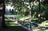
- Blake GardenBlake Garden, KensingtonBlake Garden is a botanical garden located at 70 Rincon Road in Kensington, California, United States. It is a teaching facility for the Department of Landscape Architecture and Environmental Planning of the University of California, Berkeley. It is also the site of Blake House, the official...
External links
- About Kensington portal website
- Kensington Fire Protection District
- Kensington Library
- Kensington Police Protection & Community Services District (KPPCSD)
- Open Directory Kensington, CA additional locality links