

Kelsey-Woodlawn, Saskatoon
Encyclopedia
| City of Saskatoon Neighbourhoods | |
|---|---|
| Kelsey-Woodlawn | |
| Lawson Suburban Development Area | |
| Population: | 860 |
| Average Family Income: | $37,454 |
| Average Household Size: | 2.2 |
| Homeownership: | 57.7% |
| Average Home Selling Price: | $70,806 |
| Municipal Ward: | 1 |
| Statistics c2005 - | |
Canadian National Railway
The Canadian National Railway Company is a Canadian Class I railway headquartered in Montreal, Quebec. CN's slogan is "North America's Railroad"....
to both the north and east. There are two older neighbourhoods, one still survives near SIAST - Kelsey
Saskatchewan Institute of Applied Science and Technology
Saskatchewan Institute of Applied Science and Technology is a diploma-granting college that has four campuses across Saskatchewan. More than 12,000 students are enrolled in its programs and has approximately 29,000 additional individual registrations....
institute on Idylwyld Drive North, and the other is the McVicar Addition near the Woodlawn Cemetery.
Location
Within the Lawson Suburban Development Area (West Side), the neighbourhood of Kelsey-Woodlawn reaches as far north as the north industrial area bearing 40A Street as its northern perimeter. The CNR train track marks the eastern boundary at Warman Road, thus encompassing the Woodlawn Cemetery. The southern most road within Kelsey-Woodlawn is 33rd Street East, and the western edge includes all the places along Idylwyld Drive. Most homes were built prior to the 60's with no new construction virtually after 1980 at all and the main tenants would be students attending SIAST on 33rd Street and Idylwyld Drive.Layout
Along the Woodlawn Cemetery is a small neighborhood known as the "McVicar Addition" The other residential community in the Kelsey Woodlawn subidivision are those who reside in the places which branch off Idylwyld DriveIdylwyld Drive
Idylwyld Drive is an arterial road in Saskatoon, Saskatchewan. It is one of the main roads in and out of the downtown area of the city.On the south side of the Senator Sid Buckwold Bridge, it is a freeway and is known as the Idylwyld Freeway. It eventually turns into Circle Drive, just east of...
. These places are named after governors general of Canada.
Throughout the remainder of the area, the streets are numerically numbered from 33rd Street and continue north to 40 A Street. The avenues are named after the provinces of Canada.
| List of Places and Avenues | |
|---|---|
| Connaught Place | Duke of Connaught Prince Arthur, Duke of Connaught and Strathearn Prince Arthur, Duke of Connaught and Strathearn was a member of the shared British and Saxe-Coburg and Gotha royal family who served as the Governor General of Canada, the 10th since Canadian Confederation.Born the seventh child and third son of Queen Victoria and Prince Albert of Saxe-Coburg and... |
| Grey Place | Earl Grey Albert Grey, 4th Earl Grey Albert Henry George Grey, 4th Earl Grey was a British nobleman and politician who served as Governor General of Canada, the ninth since Canadian Confederation.... |
| Aberdeen Place | Lord Aberdeen John Hamilton-Gordon, 1st Marquess of Aberdeen and Temair John Campbell Hamilton-Gordon, 1st Marquess of Aberdeen and Temair, KT, GCMG, GCVO, PC , known as The Earl of Aberdeen from 1870 to 1916, was a Scottish politician... |
| Minto Place | Earl of Minto Gilbert Elliot-Murray-Kynynmound, 4th Earl of Minto Gilbert John Elliot-Murray-Kynynmound, 4th Earl of Minto was a British nobleman and politician who served as Governor General of Canada, the eighth since Canadian Confederation, and as Viceroy and Governor-General of India, the country's 17th.-Early life and career:Minto was born in London, the... |
| Stanley Place | Lord Stanley of Preston Frederick Stanley, 16th Earl of Derby Frederick Arthur Stanley, 16th Earl of Derby KG, GCB, GCVO, PC , known as Frederick Stanley until 1886 and as Lord Stanley of Preston between 1886 and 1893, was a Conservative Party politician in the United Kingdom who served as Colonial Secretary from 1885 to 1886 and the sixth Governor General... |
| Saskatchewan Avenue | Saskatchewan Saskatchewan Saskatchewan is a prairie province in Canada, which has an area of . Saskatchewan is bordered on the west by Alberta, on the north by the Northwest Territories, on the east by Manitoba, and on the south by the U.S. states of Montana and North Dakota.... |
| Alberta Avenue | Alberta Alberta Alberta is a province of Canada. It had an estimated population of 3.7 million in 2010 making it the most populous of Canada's three prairie provinces... |
| Quebec Avenue | Quebec Quebec Quebec or is a province in east-central Canada. It is the only Canadian province with a predominantly French-speaking population and the only one whose sole official language is French at the provincial level.... |
| Ontario Avenue | Ontario Ontario Ontario is a province of Canada, located in east-central Canada. It is Canada's most populous province and second largest in total area. It is home to the nation's most populous city, Toronto, and the nation's capital, Ottawa.... |
History
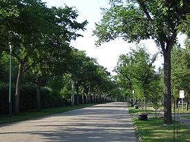
The Wood Lawn Cemetery is the only active municipal cemetery within city limits. It replaced the first cemetery - Nutana Pioneer Cemetery in 1910.Next of Kin Memorial Avenue
Next of Kin Memorial Avenue
Next of Kin Memorial Avenue is a National Historic Site of Canada which is part of Woodlawn Cemetery, Saskatoon, Saskatchewan, Canada.-Plaque 2:...
is bedecked with many planted trees honoring those who gave the ultimate sacrifice in war engagements. This Road of Remembrance was designated in 1993 as a National Historic Site.
Shopping
Within Kelsey-Woodlawn are industrial areas interspersed with the residential areas. The business and industrial areas stem off the Central Business District Warehouse area. The CNR rail yards were first located down town, and there are still CPR spur lines throughout the Kelsey Woodlawn Subdivision. Shopping is available at several various strip malls along Idylwyld Drive North, Quebec Avenue and 33rd Street East.Area Parks
- Dr. J. Valens Park 2.1 acres (8,498.4 m²)
- Industrial Park 6 acres (24,281.2 m²)
Transportation
Idylwyld Drive has had many titles: Avenue A, (Highway 11Saskatchewan Highway 11
Highway 11 is a major north-south highway in Saskatchewan, Canada that connects the province's three largest cities: Regina, Saskatoon and Prince Albert. It is a structural pavement major arterial highway which is approximately long. It is also known as the Louis Riel Trail after the 19th century...
and most currently Louis Riel Trail. It is a main thoroughfare through the city connecting Regina
Regina, Saskatchewan
Regina is the capital city of the Canadian province of Saskatchewan. The city is the second-largest in the province and a cultural and commercial centre for southern Saskatchewan. It is governed by Regina City Council. Regina is the cathedral city of the Roman Catholic and Romanian Orthodox...
, Saskatoon
Saskatoon
Saskatoon is a city in central Saskatchewan, Canada, on the South Saskatchewan River. Residents of the city of Saskatoon are called Saskatonians. The city is surrounded by the Rural Municipality of Corman Park No. 344....
and Prince Albert, Saskatchewan
Prince Albert, Saskatchewan
Prince Albert is the third-largest city in Saskatchewan, Canada. It is situated in the centre of the province on the banks of the North Saskatchewan River. The city is known as the "Gateway to the North" because it is the last major centre along the route to the resources of northern Saskatchewan...
. It also connects west Saskatoon with the bedroom communities of Warman
Warman, Saskatchewan
-History:The town of Warman was born when the Canadian National Railway running from Humboldt to North Battleford intersected with the Canadian Pacific Railway running from Regina to Prince Albert. This took place in the fall of 1904....
and Martensville
Martensville, Saskatchewan
Martensville is a city located in Saskatchewan, Canada, just north of Saskatoon, and south west of Clarkboro Ferry which crosses the South Saskatchewan River. Martensville is one of the fastest growing communities in Saskatchewan, with the population growing 25% between 1996 and 2001. It is...
City Transit
Kelsey-Woodlawn serviced by City Transit Bus Routes Saskatoon TransitSaskatoon Transit
Saskatoon Transit is the public transport arm of the City of Saskatoon, Saskatchewan, Canada. It operates a fleet of diesel buses. A total of 23 bus routes serve every area of the city, carrying approximately 11 million passengers in 2008...
.
Location
Coordinates: 52°9′3″N 106°39′18″W| North: North Industrial | ||
| West: Mayfair | Kelsey-Woodlawn | East: North Park |
| South: Central Industrial |