

Karakuwa, Miyagi
Encyclopedia
Towns of Japan
A town is a local administrative unit in Japan. It is a local public body along with prefecture , city , and village...
located in the extreme northeast of Miyagi Prefecture
Miyagi Prefecture
is a prefecture of Japan in the Tōhoku Region on Honshu island. The capital is Sendai.- History :Miyagi Prefecture was formerly part of the province of Mutsu. Mutsu Province, on northern Honshu, was one of the last provinces to be formed as land was taken from the indigenous Emishi, and became the...
, bordering Kesennuma
Kesennuma, Miyagi
is a city located in the extreme northeast of Miyagi Prefecture, Japan, founded on June 1, 1953. It wraps around the western part of Kesennuma Bay, and also includes the island of Ōshima...
to the north-west and Rikuzentakata
Rikuzentakata, Iwate
is a city in Iwate, Japan.In the quinquennial census of 2010, the city had a population of 23,302 . With a total area of 232.29 km² the density is 100 persons per km². The city was founded on January 1, 1955. The 2011 Tōhoku earthquake and tsunami caused extensive damage to the city.- Politics...
, part of Iwate Prefecture
Iwate Prefecture
is the second largest prefecture of Japan after Hokkaido. It is located in the Tōhoku region of Honshū island and contains the island's easternmost point. The capital is Morioka. Iwate has the lowest population density of any prefecture outside Hokkaido...
, to the north, and with Kesennuma Bay including Oshima island to the west, Hirota Bay to the north-east, and the Pacific Ocean
Pacific Ocean
The Pacific Ocean is the largest of the Earth's oceanic divisions. It extends from the Arctic in the north to the Southern Ocean in the south, bounded by Asia and Australia in the west, and the Americas in the east.At 165.2 million square kilometres in area, this largest division of the World...
to the south and east.
On March 31, 2006, Karakuwa was merged into the neighboring city of Kesennuma
Kesennuma, Miyagi
is a city located in the extreme northeast of Miyagi Prefecture, Japan, founded on June 1, 1953. It wraps around the western part of Kesennuma Bay, and also includes the island of Ōshima...
and is no longer an independent municipality
Municipalities of Japan
Japan has three levels of government: national, prefectural, and municipal. The nation is divided into 47 prefectures. Each prefecture consists of numerous municipalities. There are four types of municipalities in Japan: cities, towns, villages and special wards...
.
The highest point in former Karakuwa is Sasanagane-yama (笹長根山 meaning 'bamboo grass with long roots mountain') (520 m), near the border with Rikuzentakata
Rikuzentakata, Iwate
is a city in Iwate, Japan.In the quinquennial census of 2010, the city had a population of 23,302 . With a total area of 232.29 km² the density is 100 persons per km². The city was founded on January 1, 1955. The 2011 Tōhoku earthquake and tsunami caused extensive damage to the city.- Politics...
, and the lowest point is sea level.
Name origin
Karakuwa's name (唐桑) literally means "ChinaChina
Chinese civilization may refer to:* China for more general discussion of the country.* Chinese culture* Greater China, the transnational community of ethnic Chinese.* History of China* Sinosphere, the area historically affected by Chinese culture...
(Tang Dynasty
Tang Dynasty
The Tang Dynasty was an imperial dynasty of China preceded by the Sui Dynasty and followed by the Five Dynasties and Ten Kingdoms Period. It was founded by the Li family, who seized power during the decline and collapse of the Sui Empire...
, specifically) Mulberry
Mulberry
Morus is a genus of flowering plants in the family Moraceae. The 10–16 species of deciduous trees it contains are commonly known as Mulberries....
", and has been used to refer to the area back to the times when it was part of a larger Kesen District
Kesen District, Iwate
is a district located in Iwate Prefecture, Japan. Kesen consists of the cities of Ōfunato and Rikuzentakata and the town of Sumita. The area of Sanriku, home to Kitasato University of Fishery Sciences, was an independent town within Kesen until 2001, when it amalgamated with Ofunato.Ofunato is a...
in Mutsu Province
Mutsu Province
was an old province of Japan in the area of Fukushima, Miyagi, Iwate and Aomori prefecture and the municipalities of Kazuno and Kosaka in Akita Prefecture...
. According to the story of where the name came from, a Chinese ship wrecked on the rocky coast, and in its hold was a mulberry
Mulberry
Morus is a genus of flowering plants in the family Moraceae. The 10–16 species of deciduous trees it contains are commonly known as Mulberries....
tree. The tree was rescued and planted, and it survived and spread to become common in the area, as did the legend.
History
Around 700 A.D., there is record of EmishiEmishi
The constituted a group of people who lived in northeastern Honshū in the Tōhoku region. They are referred to as in contemporary sources. Some Emishi tribes resisted the rule of the Japanese Emperors during the late Nara and early Heian periods...
presenting local marine products at the Imperial Court
Imperial Court
An Imperial Court is the noble court of an empire .For example:*The noble court of an Emperor of China, Emperor of Japan, Emperor of Ethiopia, Emperor of Austria, Emperor of India, Emperor of Persia, etc....
, which may have encouraged immigration to the area. The area remained peaceful during the Nara period
Nara period
The of the history of Japan covers the years from AD 710 to 794. Empress Gemmei established the capital of Heijō-kyō . Except for 5 years , when the capital was briefly moved again, it remained the capital of Japanese civilization until Emperor Kammu established a new capital, Nagaoka-kyō, in 784...
, due to the powerful influence of the Minamoto Clan. However, during the Heian Period
Heian period
The is the last division of classical Japanese history, running from 794 to 1185. The period is named after the capital city of Heian-kyō, or modern Kyōto. It is the period in Japanese history when Buddhism, Taoism and other Chinese influences were at their height...
, the Minamotos were defeated by Taira no Kiyomori
Taira no Kiyomori
was a general of the late Heian period of Japan. He established the first samurai-dominated administrative government in the history of Japan.After the death of his father Taira no Tadamori in 1153, Kiyomori assumed control of the Taira clan and ambitiously entered the political realm in which he...
in the Heiji Rebellion
Heiji Rebellion
The was a short civil war fought in order to resolve a dispute about political power. The Heiji no ran encompassed clashes between rival subjects of the cloistered Emperor Go-Shirakawa of Japan in 1159. It was preceded by the Hōgen Rebellion in 1156...
. The Kasai Clan received the region, but were left heirless near the end of the Azuchi-Momoyama period
Azuchi-Momoyama period
The came at the end of the Warring States Period in Japan, when the political unification that preceded the establishment of the Tokugawa shogunate took place. It spans the years from approximately 1573 to 1603, during which time Oda Nobunaga and his successor, Toyotomi Hideyoshi, imposed order...
. After the Battle of Sekigahara
Battle of Sekigahara
The , popularly known as the , was a decisive battle on October 21, 1600 which cleared the path to the Shogunate for Tokugawa Ieyasu...
in 1600, the area was given to Date Masamune
Date Masamune
was a regional strongman of Japan's Azuchi-Momoyama period through early Edo period. Heir to a long line of powerful daimyo in the Tōhoku region, he went on to found the modern-day city of Sendai...
as part of his lands.
During the Meiji Restoration
Meiji Restoration
The , also known as the Meiji Ishin, Revolution, Reform or Renewal, was a chain of events that restored imperial rule to Japan in 1868...
, it was taken from the Date clan as punishment for their involvement and given to the Takasaki Clan to administer, becoming part of Motoyoshi District
Motoyoshi District, Miyagi
is a district located in Miyagi Prefecture, Japan.As of the Karakuwa merger but with 2010 population estimates, the district has an estimated population of 17,296 and a population density of 106 persons per km²...
in 1868, then becoming part of several short-lived prefectures before finally becoming part of Miyagi Prefecture
Miyagi Prefecture
is a prefecture of Japan in the Tōhoku Region on Honshu island. The capital is Sendai.- History :Miyagi Prefecture was formerly part of the province of Mutsu. Mutsu Province, on northern Honshu, was one of the last provinces to be formed as land was taken from the indigenous Emishi, and became the...
on April 18, 1876.
In 1889, the two villages in the area, Karakuwa and Koharagi (小原木 meaning 'small, original tree') merged to form a larger village called Karakuwa, then incorporated into a town in 1955.
In 2004 and 2005 there were discussions with Motoyoshi
Motoyoshi, Miyagi
was a town located in Motoyoshi District, Miyagi, Japan.In 2003, the town had an estimated population of 11,716 and a population density of 109.80 persons per km². The total area was 106.70 km². Motoyoshi was divided into four districts: Magome, Koizumi, Tsuya, and Ohya. Koizumi and Ohya were both...
and Kesennuma
Kesennuma, Miyagi
is a city located in the extreme northeast of Miyagi Prefecture, Japan, founded on June 1, 1953. It wraps around the western part of Kesennuma Bay, and also includes the island of Ōshima...
regarding a merge to create a larger city. Although Motoyoshi
Motoyoshi, Miyagi
was a town located in Motoyoshi District, Miyagi, Japan.In 2003, the town had an estimated population of 11,716 and a population density of 109.80 persons per km². The total area was 106.70 km². Motoyoshi was divided into four districts: Magome, Koizumi, Tsuya, and Ohya. Koizumi and Ohya were both...
withdrew from the talks, an agreement to merge was made with Kesennuma
Kesennuma, Miyagi
is a city located in the extreme northeast of Miyagi Prefecture, Japan, founded on June 1, 1953. It wraps around the western part of Kesennuma Bay, and also includes the island of Ōshima...
. On March 31, 2006, Karakuwa ceased to exist as a separate town.
Geography
The town center was located at the base of a rocky peninsula which juts out into the Pacific Ocean, a small extension of the north-south running mountains in the area. Most of the underlying rock is granite, though there is significant marble as well. These hard rock mountains make the land an abundance of sharp hills and valleys, and also give the area many small bays. There is some farmland, but the hills make large open fields impossible.Like much of Japan, Karakuwa is prone to earthquakes. Large earthquakes with centers in the ocean from those off western Hokkaido to those off to Oshika peninsula to the south have been felt in the area. Tsunami
Tsunami
A tsunami is a series of water waves caused by the displacement of a large volume of a body of water, typically an ocean or a large lake...
can also be a danger; in recent times, large waves hit the area after a local earthquake in 1896
1896 Meiji-Sanriku earthquake
The 1896 Meiji-Sanriku earthquake was highly destructive, generating one of the most devastating tsunamis in Japanese history, destroying about 9,000 homes and causing at least 22,000 deaths. This magnitude 7.2 event occurred at 19:32 on June 15, 1896...
, and after the Chilean earthquake of 1960.
The peninsula area of the former town, from the town center to the south-east is about 3 km (1.9 mi) long, and about 1 km (0.621372736649807 mi) wide. The town extended another 4 km (2.5 mi) up the coastline to include the Koharagi area, and 1 km (0.6) along the coast facing Oshima island. There are a few small streams along the peninsula, the largest stretching 2 km (1.2 mi) inland towards Sasanagane-yama, which lies another kilometer (0.6 miles) beyond the streams source at the widest point in Karakuwa.
Economy
The local economy has some mixed farming, including a few apple orchards, but due to the rocky granite and marble coastline, which favours small ports over farmland, the focus is on commercial deep-sea fishingFishing
Fishing is the activity of trying to catch wild fish. Fish are normally caught in the wild. Techniques for catching fish include hand gathering, spearing, netting, angling and trapping....
. There is also some commercial activity in processing the catch, and the rugged beauty of the coastline encourages significant tourism
Tourism
Tourism is travel for recreational, leisure or business purposes. The World Tourism Organization defines tourists as people "traveling to and staying in places outside their usual environment for not more than one consecutive year for leisure, business and other purposes".Tourism has become a...
.
Education
There are three elementary schools and two junior high schools in former Karakuwa. Nakai (中井小学校 -shōgakkō) and Karakuwa Elementary in the south feed Karakuwa Junior High, and in the north Koharagi Elementary students go to Koharagi Junior High. There were no high schools in the town; students must go to Kesennuma, Rikuzentakata or farther to continue their education.Transportation
- Route 45, to SendaiSendai, Miyagiis the capital city of Miyagi Prefecture, Japan, and the largest city in the Tōhoku Region. In 2005, the city had a population of one million, and was one of Japan's 19 designated cities...
via Kesennuma, major highway - Route 26, to Kesennuma, older, winding highway
- Route 239, connects Route 45 and 26 along the east coast of the Karakuwa peninsula
- JR EastEast Japan Railway Companyis the largest passenger railway company in the world and one of the seven Japan Railways Group companies. The company name is officially abbreviated as JR East in English, and as in Japanese. The company's headquarters are in Yoyogi, Shibuya, Tokyo....
Kesennuma LineKesennuma LineThe is a local rail line in Japan. Part of the East Japan Railway Company system, it runs from Maeyachi Station in Ishinomaki, Miyagi to Kesennuma Station in Kesennuma, Miyagi...
(rail), to Maeyachi StationMaeyachi Stationis a JR East railway station located in Ishinomaki, Miyagi, Japan. It is the southern terminus of the JR Kesennuma Line, and is also a station on the Ishinomaki Line.It was unaffected by the 2011 Japanese tsunami.-Lines:*JR East Kesennuma Line...
in Ishinomaki with connections to SendaiSendai, Miyagiis the capital city of Miyagi Prefecture, Japan, and the largest city in the Tōhoku Region. In 2005, the city had a population of one million, and was one of Japan's 19 designated cities...
from Kesennuma StationKesennuma StationKesennuma Station is a train station in central Kesennuma, Miyagi, Japan. It forms the junction of the JR East Ōfunato and Kesennuma lines...
in Kesennuma - JR EastEast Japan Railway Companyis the largest passenger railway company in the world and one of the seven Japan Railways Group companies. The company name is officially abbreviated as JR East in English, and as in Japanese. The company's headquarters are in Yoyogi, Shibuya, Tokyo....
Ōfunato LineOfunato LineThe is a local rail line in Japan. Part of the East Japan Railway Company system, it runs as a spur line from Ichinoseki Station in Ichinoseki, Iwate, in central Japan to Sakari Station in Ōfunato, Iwate, on the coast...
(rail), to Ichinoseki Station in IchinosekiIchinoseki, Iwateis a city located towards the south of Iwate Prefecture, Japan and situated on the Iwai River. After Morioka and Ōshū, it is the third largest city in the prefecture.-Description:...
and Sakari StationSakari StationSakari Station is a train station located on the JR Ōfunato Line in Ōfunato, Iwate, Japan. This station is the largest in Ōfunato City.-Lines:*JR East Ōfunato Line*Sanriku Railway Company South Rias Line...
in ŌfunatoOfunato, Iwateis a coastal city located in Iwate, Japan.It was founded on April 1, 1952.On November 15, 2001, the town of Sanriku, from Kesen District, was merged into Ōfunato....
from Shishiori-Karakuwa StationShishiori-Karakuwa StationShishiori-Karakuwa Station is a train station located on the JR Ōfunato Line in northern part of Kesennuma, Miyagi, Japan.-History:*March 19, 1932: Station opensas Shishiori Station....
or Kesennuma StationKesennuma StationKesennuma Station is a train station in central Kesennuma, Miyagi, Japan. It forms the junction of the JR East Ōfunato and Kesennuma lines...
in Kesennuma.
(Note: There are no train stations in Karakuwa itself.)
Tourist attractions
- Oogama-Hanzou (巨釜ー半造) is located off Route 26, on the east coast of the Karakuwa peninsula. It is a park area with walking trails along the rugged, dark marbleMarbleMarble is a metamorphic rock composed of recrystallized carbonate minerals, most commonly calcite or dolomite.Geologists use the term "marble" to refer to metamorphosed limestone; however stonemasons use the term more broadly to encompass unmetamorphosed limestone.Marble is commonly used for...
of the coast line. The feature attraction and the former town's symbol, Oreishi (折石), is here, a marble column rising from the ocean which stands 16 m tall and 3 m wide. Prior to the Sanriku tsunamiTsunamiA tsunami is a series of water waves caused by the displacement of a large volume of a body of water, typically an ocean or a large lake...
breaking off the top in 1896, it stood an additional 2 m taller.
- Osaki Shrine (御崎神社 meaning 'shrine on land looking over water') is located at the end of Route 26 at the southernmost tip of the Karakuwan peninsula. A large shrine is here, with paths with branches entwined above and more views of the rocky coast line. A connecting path leads up the coast to eventually join with Oogama-Hanzou. The Karakuwa Tsunami Museum is located in the same area. Built in 1984, it's billed as the only place in Japan where you can feel the simulated experience of a tsunamiTsunamiA tsunami is a series of water waves caused by the displacement of a large volume of a body of water, typically an ocean or a large lake...
.
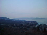
- Isaribi Park (漁火パーク; meaning 'fishing fire park') is located off Route 26. Isaribi Park contains the highest point on the Karakuwan peninsula, a restaurant, gift shop, small playground and go-kartKart racingKart racing or karting is a variant of open-wheel motorsport with small, open, four-wheeled vehicles called karts, go-karts, or gearbox/shifter karts depending on the design. They are usually raced on scaled-down circuits...
track are at the base. A short climb to the top reveals a small shrine and a lookout which allows views of the Karakuwan peninsula to the south, Oshima island and Kesennuma to the west, and IwateIwateIwate can refer to:* Iwate Prefecture, a prefecture of Japan.* Iwate, Iwate, a town in Iwate Prefecture, Japan.* Japanese cruiser Iwate, an armored cruiser of the Imperial Japanese Navy from 1900 to the end of World War II....
to the north-east.
- 9-9 Sound Beach (九九鳴き浜) is located off Highway 26 between the former town centre and Kesennuma, with an approximately three kilometre walk from the access point to the beach. The beach is so named because the mixed porcelain, granite, and sand stone of the beach is said to make a 'kyuu-kyuu' or 'ku-ku' sound when walked on. (Kyuu (きゅう) and ku (く) are the two pronunciations of the number nine (九) in JapaneseJapanese languageis a language spoken by over 130 million people in Japan and in Japanese emigrant communities. It is a member of the Japonic language family, which has a number of proposed relationships with other languages, none of which has gained wide acceptance among historical linguists .Japanese is an...
.)
- Dairiseki Coast (大理石海岸 meaning 'marble coast') is located off Highway 45 close to the MiyagiMiyagi Prefectureis a prefecture of Japan in the Tōhoku Region on Honshu island. The capital is Sendai.- History :Miyagi Prefecture was formerly part of the province of Mutsu. Mutsu Province, on northern Honshu, was one of the last provinces to be formed as land was taken from the indigenous Emishi, and became the...
-IwateIwate Prefectureis the second largest prefecture of Japan after Hokkaido. It is located in the Tōhoku region of Honshū island and contains the island's easternmost point. The capital is Morioka. Iwate has the lowest population density of any prefecture outside Hokkaido...
border. The coastline of this area features white marbleMarbleMarble is a metamorphic rock composed of recrystallized carbonate minerals, most commonly calcite or dolomite.Geologists use the term "marble" to refer to metamorphosed limestone; however stonemasons use the term more broadly to encompass unmetamorphosed limestone.Marble is commonly used for...
, contrasting the darker colours found in most of the area.
- The entire coastline of Karakuwa forms part of Rikuchu Coast National Park. (陸中海岸国立公園)