
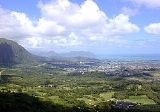
Kane'ohe, Hawai'i
Encyclopedia
Kāneohe is a census-designated place
(CDP) included in the City and County of Honolulu
and located in Hawaii
state District of Koolaupoko on the Island of Oahu
. In the Hawaiian language
, kāne ohe means "bamboo man". According to an ancient Hawaiian story
a local woman compared her husband's cruelty to the sharp edge of cutting bamboo; thus the place was named Kāneohe or "Bamboo man". The population was 34,970 at the 2000 census. Kāneohe is the largest of several communities along Kāneohe Bay and one of the two largest residential communities on the windward side of Oahu (the other is Kailua). The commercial center of the town is spread mostly along Kamehameha Highway.
From ancient times, Kāneohe was important as an agricultural area, owing to an abundance of rainfall. Today, Kāneohe is mostly a residential community, with very little agriculture in evidence. The only commercial crop of any consequence in the area is banana
.
Features of note are Hoomaluhia Botanical Garden
and the new Hawaii National Veterans Cemetery. Access to Kāneohe Bay is mainly from the public pier and boat ramp located at nearby Heeia Kea. Access to Coconut Island (restricted) is from the state pier off Lilipuna Road. Marine Corps Base Hawaii
lies across the south end of Kāneohe Bay from the central part of Kāneohe, although the town stretches along Kāneohe Bay Drive to the base perimeter.
The ZIP code
for Kaneohe is 96744.
There are three golf courses in Kāneohe: Pali Golf Course (public), Koolau Golf Club (privately owned but open to the public), and Bayview Golf Park (privately owned but open to the public).
, and the latter connecting to Interstate H-3
and (at Castle Junction) Pali Highway (State Rte. 61) to Honolulu
. Likelike Highway (State Rte. 63) runs southwest over and through the Koolau to Honolulu. Likelike provides connections to Kahekili Highway and Heeia, and H-3 southbound to Hālawa
. The first three exits on the windward side of Interstate H-3
east (north) bound access Kāneohe. Following Kamehameha Highway northward from Kāneohe (State Rte. 830) leads through Heeia to Heeia Kea.
According to the United States Census Bureau
, the CDP has a total area of 8.5 square miles (22 km²), of which, 6.6 square miles (17.1 km²) of it is land and 1.9 square miles (4.9 km²) of it is water. The total area is 22.80% water, although this is merely a portion of Kāneohe Bay included in the census tract.
was 5,320.7 people per square mile (2,055.1/km²). There were 11,472 housing units at an average density of 1,745.5 per square mile (674.2/km²). The racial makeup of the CDP was 20.49% White, 0.81% Black or African American, 0.20% Native American, 38.48% Asian, 11.44% Pacific Islander, 0.68% from other races, and 27.90% from two or more races. 7.21% of the population were Hispanic or Latino of any race.
There were 10,976 households out of which 32.7% have children under the age of 18 living with them, 60.4% were married couples
living together, 13.7% had a female householder with no husband present, and 20.9% were non-families. 15.4% of all households were made up of individuals and 6.5% had someone living alone who is 65 years of age or older. The average household size was 3.14 and the average family size is 3.48.
The population was spread out with 24.6% under the age of 18, 8.2% from 18 to 24, 29.0% from 25 to 44, 23.4% from 45 to 64, and 14.7% who were 65 years of age or older. The median age was 38 years. For every 100 females there were 96.1 males. For every 100 females age 18 and over, there were 93.2 males.
The median income for a household in Kāneohe in 2000 was $66,006, and the median income for a family was $71,316. Males had a median income of $40,389 versus $31,504 for females. The per capita income
for the CDP was $23,476. 6.1% of the population and 4.4% of families were below the poverty line. Out of the total population, 7.3% of those under the age of 18 and 4.2% of those 65 and older were living below the poverty line.
operates the Kaneohe Substation in Kaneohe.
Elementary schools in Kaneohe CDP include Heeia, Kapunahala, Benjamin Parker, Kaneohe El., and Puohala. James B. Castle High School
is located in Kaneohe CDP.
Also within the boundaries of Kaneohe CDP are the Hakipuu Learning Center, a public charter school for grades 7 through 12, and four private schools: Koolau Baptist Academy, St Ann’s, St Mark Lutheran School, and Windward Nazarene Academy.
Windward Community College
, part of the expanding state college system, is located on the south side of central Kāneohe. Hawaii Pacific University
operates its Windward Hawaiʻi Loa campus on Kamehameha Highway near Castle Junction.
Census-designated place
A census-designated place is a concentration of population identified by the United States Census Bureau for statistical purposes. CDPs are delineated for each decennial census as the statistical counterparts of incorporated places such as cities, towns and villages...
(CDP) included in the City and County of Honolulu
Honolulu County, Hawaii
The City and County of Honolulu is a consolidated city–county located in the U.S. state of Hawaii. The municipality and county includes both the urban district of Honolulu and the rest of the island of Oahu, as well as several minor outlying islands, including all of the Northwestern Hawaiian...
and located in Hawaii
Hawaii
Hawaii is the newest of the 50 U.S. states , and is the only U.S. state made up entirely of islands. It is the northernmost island group in Polynesia, occupying most of an archipelago in the central Pacific Ocean, southwest of the continental United States, southeast of Japan, and northeast of...
state District of Koolaupoko on the Island of Oahu
Oahu
Oahu or Oahu , known as "The Gathering Place", is the third largest of the Hawaiian Islands and most populous of the islands in the U.S. state of Hawaii. The state capital Honolulu is located on the southeast coast...
. In the Hawaiian language
Hawaiian language
The Hawaiian language is a Polynesian language that takes its name from Hawaii, the largest island in the tropical North Pacific archipelago where it developed. Hawaiian, along with English, is an official language of the state of Hawaii...
, kāne ohe means "bamboo man". According to an ancient Hawaiian story
Hawaiian mythology
Hawaiian mythology refers to the legends, historical tales and sayings of the ancient Hawaiian people. It is considered a variant of a more general Polynesian mythology, developing its own unique character for several centuries before about 1800. It is associated with the Hawaiian religion...
a local woman compared her husband's cruelty to the sharp edge of cutting bamboo; thus the place was named Kāneohe or "Bamboo man". The population was 34,970 at the 2000 census. Kāneohe is the largest of several communities along Kāneohe Bay and one of the two largest residential communities on the windward side of Oahu (the other is Kailua). The commercial center of the town is spread mostly along Kamehameha Highway.
From ancient times, Kāneohe was important as an agricultural area, owing to an abundance of rainfall. Today, Kāneohe is mostly a residential community, with very little agriculture in evidence. The only commercial crop of any consequence in the area is banana
Banana
Banana is the common name for herbaceous plants of the genus Musa and for the fruit they produce. Bananas come in a variety of sizes and colors when ripe, including yellow, purple, and red....
.
Features of note are Hoomaluhia Botanical Garden
Ho'omaluhia Botanical Garden
The Ho'omaluhia Botanical Garden is a botanical garden located at 45-680 Luluku Road, Kāne'ohe, Oahu, Hawaii. It is part of the Honolulu Botanical Gardens, and is open daily, without charge, except for Christmas Day and New Year's Day.The garden was established in 1982, and designed and built by...
and the new Hawaii National Veterans Cemetery. Access to Kāneohe Bay is mainly from the public pier and boat ramp located at nearby Heeia Kea. Access to Coconut Island (restricted) is from the state pier off Lilipuna Road. Marine Corps Base Hawaii
Marine Corps Base Hawaii
Marine Corps Base Hawaii , formerly Marine Corps Air Station, Kaneohe Bay and originally Naval Air Station Kaneohe Bay, is a U.S. Marine Corps base facility and air station located on the Mokapu Peninsula of windward O'ahu in the City & County of Honolulu. As of the 2000 Census, the base had a...
lies across the south end of Kāneohe Bay from the central part of Kāneohe, although the town stretches along Kāneohe Bay Drive to the base perimeter.
The ZIP code
ZIP Code
ZIP codes are a system of postal codes used by the United States Postal Service since 1963. The term ZIP, an acronym for Zone Improvement Plan, is properly written in capital letters and was chosen to suggest that the mail travels more efficiently, and therefore more quickly, when senders use the...
for Kaneohe is 96744.
There are three golf courses in Kāneohe: Pali Golf Course (public), Koolau Golf Club (privately owned but open to the public), and Bayview Golf Park (privately owned but open to the public).
Geography
Kaneohe is located at 21°24′33"N 157°47′57"W (21.409200, -157.799084). Nearby towns include Kailua to the east, reached either by Kāneohe Bay Drive (State Rte. 630) or Kamehameha Highway (State Rte. 83), the former also providing a connection to Marine Corps Base HawaiiMarine Corps Base Hawaii
Marine Corps Base Hawaii , formerly Marine Corps Air Station, Kaneohe Bay and originally Naval Air Station Kaneohe Bay, is a U.S. Marine Corps base facility and air station located on the Mokapu Peninsula of windward O'ahu in the City & County of Honolulu. As of the 2000 Census, the base had a...
, and the latter connecting to Interstate H-3
Interstate H-3
Interstate H-3 is an intrastate Interstate Highway located on the island of O'ahu in the state of Hawai'i in the United States. H-3 is also known as the John A. Burns Freeway...
and (at Castle Junction) Pali Highway (State Rte. 61) to Honolulu
Honolulu, Hawaii
Honolulu is the capital and the most populous city of the U.S. state of Hawaii. Honolulu is the southernmost major U.S. city. Although the name "Honolulu" refers to the urban area on the southeastern shore of the island of Oahu, the city and county government are consolidated as the City and...
. Likelike Highway (State Rte. 63) runs southwest over and through the Koolau to Honolulu. Likelike provides connections to Kahekili Highway and Heeia, and H-3 southbound to Hālawa
Halawa, Hawaii
Halawa is a census-designated place in the ‘Ewa District of Honolulu County, Hawaii, United States. Halawa Stream branches into two valleys: North and South Halawa; North Halawa is the larger stream and fluvial feature. Their confluence is within the H-3/H-201 highways exchange. Most of Halawa...
. The first three exits on the windward side of Interstate H-3
Interstate H-3
Interstate H-3 is an intrastate Interstate Highway located on the island of O'ahu in the state of Hawai'i in the United States. H-3 is also known as the John A. Burns Freeway...
east (north) bound access Kāneohe. Following Kamehameha Highway northward from Kāneohe (State Rte. 830) leads through Heeia to Heeia Kea.
According to the United States Census Bureau
United States Census Bureau
The United States Census Bureau is the government agency that is responsible for the United States Census. It also gathers other national demographic and economic data...
, the CDP has a total area of 8.5 square miles (22 km²), of which, 6.6 square miles (17.1 km²) of it is land and 1.9 square miles (4.9 km²) of it is water. The total area is 22.80% water, although this is merely a portion of Kāneohe Bay included in the census tract.
Demographics
As of the 2000 Census, there were 34,970 people, 10,976 households, and 8,682 families residing in Kāneohe. The population densityPopulation density
Population density is a measurement of population per unit area or unit volume. It is frequently applied to living organisms, and particularly to humans...
was 5,320.7 people per square mile (2,055.1/km²). There were 11,472 housing units at an average density of 1,745.5 per square mile (674.2/km²). The racial makeup of the CDP was 20.49% White, 0.81% Black or African American, 0.20% Native American, 38.48% Asian, 11.44% Pacific Islander, 0.68% from other races, and 27.90% from two or more races. 7.21% of the population were Hispanic or Latino of any race.
There were 10,976 households out of which 32.7% have children under the age of 18 living with them, 60.4% were married couples
Marriage
Marriage is a social union or legal contract between people that creates kinship. It is an institution in which interpersonal relationships, usually intimate and sexual, are acknowledged in a variety of ways, depending on the culture or subculture in which it is found...
living together, 13.7% had a female householder with no husband present, and 20.9% were non-families. 15.4% of all households were made up of individuals and 6.5% had someone living alone who is 65 years of age or older. The average household size was 3.14 and the average family size is 3.48.
The population was spread out with 24.6% under the age of 18, 8.2% from 18 to 24, 29.0% from 25 to 44, 23.4% from 45 to 64, and 14.7% who were 65 years of age or older. The median age was 38 years. For every 100 females there were 96.1 males. For every 100 females age 18 and over, there were 93.2 males.
The median income for a household in Kāneohe in 2000 was $66,006, and the median income for a family was $71,316. Males had a median income of $40,389 versus $31,504 for females. The per capita income
Per capita income
Per capita income or income per person is a measure of mean income within an economic aggregate, such as a country or city. It is calculated by taking a measure of all sources of income in the aggregate and dividing it by the total population...
for the CDP was $23,476. 6.1% of the population and 4.4% of families were below the poverty line. Out of the total population, 7.3% of those under the age of 18 and 4.2% of those 65 and older were living below the poverty line.
Government and infrastructure
The Honolulu Police DepartmentHonolulu Police Department
The Honolulu Police Department is the principal law enforcement agency of the City and County of Honolulu, Hawai'i, headquartered in the Alapa'i Police Headquarters in Honolulu CDP....
operates the Kaneohe Substation in Kaneohe.
Education
Hawaii Department of Education operates public schools.Elementary schools in Kaneohe CDP include Heeia, Kapunahala, Benjamin Parker, Kaneohe El., and Puohala. James B. Castle High School
James B. Castle High School
For schools of the same name, see Castle High SchoolJames Bicknell Castle High School, more commonly James B. Castle High School or simply Castle High School, is a public coeducational high school located in Kāneohe CDP, City and County of Honolulu, Hawaii. The school serves grades 9 through 12 and...
is located in Kaneohe CDP.
Also within the boundaries of Kaneohe CDP are the Hakipuu Learning Center, a public charter school for grades 7 through 12, and four private schools: Koolau Baptist Academy, St Ann’s, St Mark Lutheran School, and Windward Nazarene Academy.
Windward Community College
Windward Community College
Windward Community College is a public, co-educational commuter college in Kāneohe CDP, City and County of Honolulu, Hawaii on the island of Oahu...
, part of the expanding state college system, is located on the south side of central Kāneohe. Hawaii Pacific University
Hawaii Pacific University
Hawaii Pacific University, also known as HPU, is a private, Nonsectarian, coeducational university located in Honolulu, Hawaii and Kaneohe, Hawaii. HPU founded in 1965 as Hawaii Pacific College by Paul C.T. Loo, Eureka Forbes, Elizabeth W...
operates its Windward Hawaiʻi Loa campus on Kamehameha Highway near Castle Junction.