
Jewell County, Kansas
Encyclopedia
Jewell County is a county located in North Central Kansas
, in the Central
United States
. As of the 2010 census, the county population was 3,077. Its county seat
and most populous city is Mankato
.
built a branch line from Neva (3 miles west of Strong City
) to Superior, Nebraska
. This branch line connected Strong City
, Neva, Rockland, Diamond Springs, Burdick
, Lost Springs
, Jacobs, Hope
, Navarre
, Enterprise
, Abilene
, Talmage
, Manchester
, Longford
, Oak Hill
, Miltonvale
, Aurora
, Huscher
, Concordia
, Kackley
, Courtland
, Webber
, Superior
. At some point, the line from Neva to Lost Springs
was pulled but the right of way has not been abandoned. This branch line was originally called "Strong City and Superior line" but later the name was shortened to the "Strong City line". In 1996, the Atchison, Topeka and Santa Fe Railway
merged with Burlington Northern Railroad
and renamed to the current BNSF Railway
. Most locals still refer to this railroad as the "Santa Fe".
, county.

 Jewell County's population was estimated to be 3,324 in the year 2006, a decrease of 440, or -11.7%, over the previous six years.
As of the U.S. Census in 2000
, there were 3,791 people, 1,695 households, and 1,098 families residing in the county. The population density
was 4 people per square mile (2/km²). There were 2,103 housing units at an average density of 2 per square mile (1/km²). The racial makeup
of the county was 98.79% White
, 0.34% Native American
, 0.05% Asian
, 0.03% Black or African American
, 0.03% Pacific Islander
, 0.05% from other races, and 0.71% from two or more races
. Hispanic
or Latino
of any race were 0.71% of the population.
There were 1,695 household
s out of which 23.70% had children under the age of 18 living with them, 58.10% were married couples
living together, 4.80% had a female householder with no husband present, and 35.20% were non-families. 32.40% of all households were made up of individuals and 18.10% had someone living alone who was 65 years of age or older. The average household size was 2.21 and the average family size was 2.80.
In the county the population was spread out with 21.90% under the age of 18, 4.40% from 18 to 24, 21.50% from 25 to 44, 26.20% from 45 to 64, and 25.90% who were 65 years of age or older. The median age was 46 years. For every 100 females there were 97.90 males. For every 100 females age 18 and over, there were 96.00 males.
The median income for a household
in the county was $30,538, and the median income for a family was $36,953. Males had a median income of $24,821 versus $18,170 for females. The per capita income
for the county was $16,644. About 8.40% of families and 11.60% of the population were below the poverty line, including 12.80% of those under age 18 and 10.90% of those age 65 or over.
. None of the cities within the county are considered governmentally independent, and all figures for the townships include those of the cities. In the following table, the population center is the largest city (or cities) included in that township's population total, if it is of a significant size.
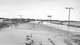
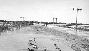
Historical
Maps
Kansas
Kansas is a US state located in the Midwestern United States. It is named after the Kansas River which flows through it, which in turn was named after the Kansa Native American tribe, which inhabited the area. The tribe's name is often said to mean "people of the wind" or "people of the south...
, in the Central
Central United States
The Central United States is sometimes conceived as between the Eastern United States and Western United States as part of a three-region model, roughly coincident with the Midwestern United States plus the western and central portions of the Southern United States; the term is also sometimes used...
United States
United States
The United States of America is a federal constitutional republic comprising fifty states and a federal district...
. As of the 2010 census, the county population was 3,077. Its county seat
County seat
A county seat is an administrative center, or seat of government, for a county or civil parish. The term is primarily used in the United States....
and most populous city is Mankato
Mankato, Kansas
Mankato is a city in and the county seat of Jewell County, Kansas, United States. As of the 2010 census, the city population was 869.-Geography:Mankato is located at...
.
19th century
In 1887, Atchison, Topeka and Santa Fe RailwayAtchison, Topeka and Santa Fe Railway
The Atchison, Topeka and Santa Fe Railway , often abbreviated as Santa Fe, was one of the larger railroads in the United States. The company was first chartered in February 1859...
built a branch line from Neva (3 miles west of Strong City
Strong City, Kansas
Strong City is a city in Chase County, Kansas, United States. It is named after William Barstow Strong, former president of the Atchison, Topeka and Santa Fe Railway. As of the 2010 census, the city population was 485.-19th century:...
) to Superior, Nebraska
Superior, Nebraska
Superior is a city in Nuckolls County, Nebraska, United States. As of the 2010 census, the city population was 1,957.Superior bills itself as the "Victorian Capital of Nebraska", and holds an annual Victorian Festival...
. This branch line connected Strong City
Strong City, Kansas
Strong City is a city in Chase County, Kansas, United States. It is named after William Barstow Strong, former president of the Atchison, Topeka and Santa Fe Railway. As of the 2010 census, the city population was 485.-19th century:...
, Neva, Rockland, Diamond Springs, Burdick
Burdick, Kansas
Burdick is an unincorporated community in southwestern Morris County, Kansas, United States. It lies along local roads south-southwest of the city of Council Grove, the county seat of Morris County. Its elevation is 1,453 feet , and it is located at...
, Lost Springs
Lost Springs, Kansas
Lost Springs is a city in Marion County, Kansas, United States. It was named for the old lost spring near the city. As of the 2010 census, the city population was 70.-19th century:...
, Jacobs, Hope
Hope, Kansas
Hope is a city in southern Dickinson County, Kansas, United States. As of the 2010 census, the city population was 368. The motto of Hope is "There Will Always Be Hope In Kansas", which is also the name of a song.-History:...
, Navarre
Navarre, Kansas
Navarre is a small unincorporated community in Dickinson County, Kansas, United States. The post office was established February 7, 1884, and discontinued September 3, 1971.-History:...
, Enterprise
Enterprise, Kansas
Enterprise is a city in Dickinson County, Kansas, United States. As of the 2010 census, the city population was 855.-History:On January 10, 1883, the Enterprise Town Company, capital $50,000, was organized. The following officers were elected: V. P. Wilson, president; John Johntz, vice-president;...
, Abilene
Abilene, Kansas
Abilene is a city in and the county seat of Dickinson County, Kansas, United States. As of the 2010 census, the city population was 6,844.-History:...
, Talmage
Talmage, Kansas
Talmage is a small unincorporated community in Dickinson County, Kansas, United States. The post office was established December 22, 1887.-History:...
, Manchester
Manchester, Kansas
Manchester is a city in Dickinson County, Kansas, United States. As of the 2010 census, the city population was 95.-History:In 1887, Atchison, Topeka and Santa Fe Railway built a branch line from Neva through Manchester to Superior, Nebraska...
, Longford
Longford, Kansas
Longford is a city in Clay County, Kansas, United States. As of the 2010 census, the city population was 79.-History:In 1887, Atchison, Topeka and Santa Fe Railway built a branch line from Neva through Longford to Superior, Nebraska...
, Oak Hill
Oak Hill, Kansas
Oak Hill is a city in Clay County, Kansas, United States. As of the 2010 census, the city population was 24.-History:In 1887, Atchison, Topeka and Santa Fe Railway built a branch line from Neva through Oak Hill to Superior, Nebraska...
, Miltonvale
Miltonvale, Kansas
Miltonvale is a city in Cloud County, Kansas, United States. As of the 2010 census, the city population was 539.-History:Miltonvale was founded on December 1, 1881.From 1909 to 1972, it was the home of Miltonvale Wesleyan College....
, Aurora
Aurora, Kansas
Aurora is a city in Cloud County, Kansas, United States. As of the 2010 census, the city population was 60.-History:In 1887, Atchison, Topeka and Santa Fe Railway built a branch line from Neva through Aurora to Superior, Nebraska...
, Huscher
Huscher, Kansas
Huscher is an unincorporated rural area in Cloud County, Kansas, United States.-History:In 1887, Atchison, Topeka and Santa Fe Railway built a branch line from Neva through Huscher to Superior, Nebraska. In 1996, the Atchison, Topeka and Santa Fe Railway merged with Burlington Northern Railroad...
, Concordia
Concordia, Kansas
Concordia is a city in and the county seat of Cloud County, Kansas, United States. Located on the Republican River in the Smoky Hills region of the Great Plains, Concordia was founded in 1871 and is an economic and cultural center in north-central Kansas...
, Kackley
Kackley, Kansas
Kackley is an unincorporated rural area in Republic County, Kansas, United States.-History:In 1887, Atchison, Topeka and Santa Fe Railway built a branch line from Neva through Kackley to Superior, Nebraska. In 1996, the Atchison, Topeka and Santa Fe Railway merged with Burlington Northern...
, Courtland
Courtland, Kansas
Courtland is a city in Republic County, Kansas, United States. As of the 2010 census, the city population was 285.-History:In 1887, Atchison, Topeka and Santa Fe Railway built a branch line from Neva through Courtland to Superior, Nebraska...
, Webber
Webber, Kansas
Webber is a city in Jewell County, Kansas, United States. As of the 2010 census, the city population was 25.-History:In 1887, Atchison, Topeka and Santa Fe Railway built a branch line from Neva through Webber to Superior, Nebraska...
, Superior
Superior, Nebraska
Superior is a city in Nuckolls County, Nebraska, United States. As of the 2010 census, the city population was 1,957.Superior bills itself as the "Victorian Capital of Nebraska", and holds an annual Victorian Festival...
. At some point, the line from Neva to Lost Springs
Lost Springs, Kansas
Lost Springs is a city in Marion County, Kansas, United States. It was named for the old lost spring near the city. As of the 2010 census, the city population was 70.-19th century:...
was pulled but the right of way has not been abandoned. This branch line was originally called "Strong City and Superior line" but later the name was shortened to the "Strong City line". In 1996, the Atchison, Topeka and Santa Fe Railway
Atchison, Topeka and Santa Fe Railway
The Atchison, Topeka and Santa Fe Railway , often abbreviated as Santa Fe, was one of the larger railroads in the United States. The company was first chartered in February 1859...
merged with Burlington Northern Railroad
Burlington Northern Railroad
The Burlington Northern Railroad was a United States-based railroad company formed from a merger of four major U.S. railroads. Burlington Northern operated between 1970 and 1996....
and renamed to the current BNSF Railway
BNSF Railway
The BNSF Railway is a wholly owned subsidiary of Berkshire Hathaway Inc., and is headquartered in Fort Worth, Texas. It is one of seven North American Class I railroads and the second largest freight railroad network in North America, second only to the Union Pacific Railroad, its primary...
. Most locals still refer to this railroad as the "Santa Fe".
Law and government
Although the Kansas Constitution was amended in 1986 to allow the sale of alcoholic liquor by the individual drink with the approval of voters, Jewell County has remained a prohibition, or "dry"Dry county
A dry county is a county in the United States whose government forbids the sale of alcoholic beverages. Some prohibit off-premises sale, some prohibit on-premises sale, and some prohibit both. Hundreds of dry counties exist across the United States, almost all of them in the South...
, county.
Geography
According to the 2000 census, the county has a total area of 914.47 square miles (2,368.5 km²), of which 909.18 square miles (2,354.8 km²) (or 99.42%) is land and 5.29 square miles (13.7 km²) (or 0.58%) is water.Adjacent counties
- Nuckolls CountyNuckolls County, NebraskaNuckolls County is a county located in the U.S. state of Nebraska. As of the 2010 census, the county population was 4,500. Its county seat is Nelson....
, NebraskaNebraskaNebraska is a state on the Great Plains of the Midwestern United States. The state's capital is Lincoln and its largest city is Omaha, on the Missouri River....
(northeast) - Republic CountyRepublic County, KansasRepublic County is a county located in the state of Kansas. As of the 2010 census, the county population was 4,980. The largest city and county seat is Belleville.-19th century:...
(east) - Cloud CountyCloud County, KansasCloud County is a county located in North Central Kansas, in the Central United States. As of the 2010 census, the county population was 9,533. Its county seat and most populous city is Concordia.-19th century:...
(southeast) - Mitchell CountyMitchell County, KansasMitchell County is a county located in the U.S. state of Kansas. As of the 2010 census, the county population was 6,373...
(south) - Osborne CountyOsborne County, KansasOsborne County is a county located in the U.S. state of Kansas. As of the 2010 census, the county population was 3,858. The largest city and county seat is Osborne.-19th century:...
(southwest) - Smith CountySmith County, KansasSmith County is a county located in the U.S. state of Kansas. The county's population was 3,853 for the 2010 census. Its county seat is Smith Center. It is named in memory of Maj. J. Nelson Smith, who was part of the 2nd Colorado Cavalry, killed in action at the Battle of Westport on October 21,...
(west) - Webster CountyWebster County, Nebraska-History:Webster County was formed in 1871. It was named after the statesman Daniel Webster.-Demographics:As of the census of 2000, there were 4,061 people, 1,708 households, and 1,118 families residing in the county. The population density was 7 people per square mile . There were 1,972 housing...
, NebraskaNebraskaNebraska is a state on the Great Plains of the Midwestern United States. The state's capital is Lincoln and its largest city is Omaha, on the Missouri River....
(northwest)
Demographics
As of the U.S. Census in 2000
United States Census, 2000
The Twenty-second United States Census, known as Census 2000 and conducted by the Census Bureau, determined the resident population of the United States on April 1, 2000, to be 281,421,906, an increase of 13.2% over the 248,709,873 persons enumerated during the 1990 Census...
, there were 3,791 people, 1,695 households, and 1,098 families residing in the county. The population density
Population density
Population density is a measurement of population per unit area or unit volume. It is frequently applied to living organisms, and particularly to humans...
was 4 people per square mile (2/km²). There were 2,103 housing units at an average density of 2 per square mile (1/km²). The racial makeup
Race (United States Census)
Race and ethnicity in the United States Census, as defined by the Federal Office of Management and Budget and the United States Census Bureau, are self-identification data items in which residents choose the race or races with which they most closely identify, and indicate whether or not they are...
of the county was 98.79% White
White American
White Americans are people of the United States who are considered or consider themselves White. The United States Census Bureau defines White people as those "having origins in any of the original peoples of Europe, the Middle East, or North Africa...
, 0.34% Native American
Native Americans in the United States
Native Americans in the United States are the indigenous peoples in North America within the boundaries of the present-day continental United States, parts of Alaska, and the island state of Hawaii. They are composed of numerous, distinct tribes, states, and ethnic groups, many of which survive as...
, 0.05% Asian
Asian American
Asian Americans are Americans of Asian descent. The U.S. Census Bureau definition of Asians as "Asian” refers to a person having origins in any of the original peoples of the Far East, Southeast Asia, or the Indian subcontinent, including, for example, Cambodia, China, India, Indonesia, Japan,...
, 0.03% Black or African American
African American
African Americans are citizens or residents of the United States who have at least partial ancestry from any of the native populations of Sub-Saharan Africa and are the direct descendants of enslaved Africans within the boundaries of the present United States...
, 0.03% Pacific Islander
Pacific Islander American
Pacific Islander Americans, also known as Oceanian Americans, are residents of the United States with original ancestry from Oceania. They represent the smallest racial group counted in the United States census of 2000. They numbered 874,000 people or 0.3 percent of the United States population...
, 0.05% from other races, and 0.71% from two or more races
Multiracial
The terms multiracial and mixed-race describe people whose ancestries come from multiple races. Unlike the term biracial, which often is only used to refer to having parents or grandparents of two different races, the term multiracial may encompass biracial people but can also include people with...
. Hispanic
Hispanic
Hispanic is a term that originally denoted a relationship to Hispania, which is to say the Iberian Peninsula: Andorra, Gibraltar, Portugal and Spain. During the Modern Era, Hispanic sometimes takes on a more limited meaning, particularly in the United States, where the term means a person of ...
or Latino
Latino
The demonyms Latino and Latina , are defined in English language dictionaries as:* "a person of Latin-American descent."* "A Latin American."* "A person of Hispanic, especially Latin-American, descent, often one living in the United States."...
of any race were 0.71% of the population.
There were 1,695 household
Household
The household is "the basic residential unit in which economic production, consumption, inheritance, child rearing, and shelter are organized and carried out"; [the household] "may or may not be synonymous with family"....
s out of which 23.70% had children under the age of 18 living with them, 58.10% were married couples
Marriage
Marriage is a social union or legal contract between people that creates kinship. It is an institution in which interpersonal relationships, usually intimate and sexual, are acknowledged in a variety of ways, depending on the culture or subculture in which it is found...
living together, 4.80% had a female householder with no husband present, and 35.20% were non-families. 32.40% of all households were made up of individuals and 18.10% had someone living alone who was 65 years of age or older. The average household size was 2.21 and the average family size was 2.80.
In the county the population was spread out with 21.90% under the age of 18, 4.40% from 18 to 24, 21.50% from 25 to 44, 26.20% from 45 to 64, and 25.90% who were 65 years of age or older. The median age was 46 years. For every 100 females there were 97.90 males. For every 100 females age 18 and over, there were 96.00 males.
The median income for a household
Median household income
The median household income is commonly used to generate data about geographic areas and divides households into two equal segments with the first half of households earning less than the median household income and the other half earning more...
in the county was $30,538, and the median income for a family was $36,953. Males had a median income of $24,821 versus $18,170 for females. The per capita income
Per capita income
Per capita income or income per person is a measure of mean income within an economic aggregate, such as a country or city. It is calculated by taking a measure of all sources of income in the aggregate and dividing it by the total population...
for the county was $16,644. About 8.40% of families and 11.60% of the population were below the poverty line, including 12.80% of those under age 18 and 10.90% of those age 65 or over.
Incorporated cities
Name and population (2004 estimate):- MankatoMankato, KansasMankato is a city in and the county seat of Jewell County, Kansas, United States. As of the 2010 census, the city population was 869.-Geography:Mankato is located at...
, 864 (county seat) - JewellJewell, KansasJewell is a city in Jewell County, Kansas, United States. As of the 2010 census, the city population was 432.-History:The City of Jewell began in 1870 as a large sod enclosure called Fort Jewell. Named in honor of Lieutenant-Colonel Lewis R. Jewell, Sixth Kansas Cavalry, who died November 30,...
, 447 - Burr OakBurr Oak, KansasBurr Oak is a city in Jewell County, Kansas, United States. As of the 2010 census, the city population was 174.-Geography:Burr Oak is located at . According to the United States Census Bureau, the city has a total area of , all of it land.-Demographics:As of the census of 2000, there were 265...
, 233 - EsbonEsbon, KansasEsbon is a city in Jewell County, Kansas, United States. As of the 2010 census, the city population was 99.-Geography:Esbon is located at . According to the United States Census Bureau, the city has a total area of , all of it land....
, 135 - FormosoFormoso, KansasFormoso is a city in Jewell County, Kansas, United States. As of the 2010 census, the city population was 93.-Geography:Formoso is located at . According to the United States Census Bureau, the city has a total area of , all of it land.-Demographics:As of the census of 2000, there were 129...
, 118 - RandallRandall, KansasRandall is a city in Jewell County, Kansas, United States. As of the 2010 census, the city population was 65.-Geography:Randall is located at . According to the United States Census Bureau, the city has a total area of , all of it land.-Demographics:As of the census of 2000, there were 90...
, 76 - WebberWebber, KansasWebber is a city in Jewell County, Kansas, United States. As of the 2010 census, the city population was 25.-History:In 1887, Atchison, Topeka and Santa Fe Railway built a branch line from Neva through Webber to Superior, Nebraska...
, 34
Townships
Jewell County is divided into twenty-five townshipsCivil township
A civil township is a widely used unit of local government in the United States, subordinate to, and geographic divisions of, a county. Specific responsibilities and the degree of autonomy vary based on each state. Civil townships are distinct from survey townships, but in states that have both,...
. None of the cities within the county are considered governmentally independent, and all figures for the townships include those of the cities. In the following table, the population center is the largest city (or cities) included in that township's population total, if it is of a significant size.
| Township | FIPS | Population center |
Population | Population density /km² (/sq mi) |
Land area km² (sq mi) | Water area km² (sq mi) | Water % | Geographic coordinates |
|---|---|---|---|---|---|---|---|---|
| Allen | 01225 | 43 | 0 (1) | 90 (35) | 0 (0) | 0.02% | 39°36′46"N 97°59′49"W | |
| Athens | 02975 | 74 | 1 (2) | 102 (39) | 0 (0) | 0 % | 39°36′13"N 98°20′7"W | |
| Browns Creek | 08725 | 64 | 1 (2) | 93 (36) | 0 (0) | 0.02% | 39°36′13"N 98°13′33"W | |
| Buffalo | 09125 | 574 | 5 (14) | 105 (41) | 0 (0) | 0.07% | 39°40′23"N 98°8′38"W | |
| Burr Oak | 09550 | 338 | 3 (9) | 102 (39) | 0 (0) | 0 % | 39°52′9"N 98°18′36"W | |
| Calvin | 10075 | 65 | 1 (2) | 81 (31) | 0 (0) | 0.04% | 39°42′19"N 98°12′51"W | |
| Center | 11750 | 1,100 | 12 (31) | 93 (36) | 0 (0) | 0.07% | 39°47′15"N 98°12′38"W | |
| Erving | 21575 | 60 | 1 (2) | 93 (36) | 0 (0) | 0.08% | 39°36′13"N 98°26′21"W | |
| Esbon | 21625 | 222 | 2 (6) | 93 (36) | 0 (0) | 0.08% | 39°48′15"N 98°26′41"W | |
| Grant | 27725 | 220 | 2 (6) | 93 (36) | 0 (0) | 0 % | 39°46′58"N 97°59′28"W | |
| Harrison | 30350 | 52 | 1 (1) | 93 (36) | 0 (0) | 0 % | 39°57′58"N 98°13′19"W | |
| Highland | 31900 | 49 | 1 (1) | 93 (36) | 0 (0) | 0.03% | 39°57′49"N 98°26′42"W | |
| Holmwood | 32800 | 49 | 1 (1) | 92 (36) | 0 (0) | 0.05% | 39°51′43"N 98°12′24"W | |
| Ionia | 34375 | 100 | 1 (3) | 102 (39) | 0 (0) | 0.11% | 39°40′55"N 98°19′55"W | |
| Jackson | 34800 | 123 | 1 (3) | 92 (35) | 1 (0) | 0.90% | 39°56′52"N 97°59′53"W | |
| Limestone | 40450 | 49 | 0 (1) | 102 (39) | 0 (0) | 0.02% | 39°47′38"N 98°18′45"W | |
| Montana | 47800 | 93 | 1 (3) | 94 (36) | 0 (0) | 0.14% | 39°57′55"N 98°5′21"W | |
| Odessa | 52125 | 34 | 0 (1) | 93 (36) | 0 (0) | 0.02% | 39°41′52"N 98°27′29"W | |
| Prairie | 57400 | 172 | 2 (5) | 96 (37) | 0 (0) | 0.02% | 39°37′40"N 98°4′12"W | |
| Richland | 59375 | 36 | 0 (1) | 83 (32) | 9 (4) | 10.13% | 39°53′41"N 98°5′40"W | |
| Sinclair | 65675 | 67 | 1 (2) | 89 (34) | 3 (1) | 2.81% | 39°52′41"N 97°59′52"W | |
| Vicksburg | 73725 | 28 | 0 (1) | 93 (36) | 0 (0) | 0 % | 39°42′4"N 97°58′45"W | |
| Walnut | 75000 | 80 | 1 (2) | 102 (39) | 0 (0) | 0.07% | 39°57′58"N 98°20′12"W | |
| Washington | 75650 | 50 | 1 (1) | 93 (36) | 0 (0) | 0 % | 39°47′3"N 98°5′36"W | |
| White Mound | 77925 | 49 | 1 (1) | 93 (36) | 0 (0) | 0.12% | 39°51′53"N 98°26′21"W | |
| Sources: | ||||||||
Education
Further reading
- History of the State of Kansas; William G. Cutler; A.T. Andreas Publisher; 1883. (Online HTML eBook)
- Kansas : A Cyclopedia of State History, Embracing Events, Institutions, Industries, Counties, Cities, Towns, Prominent Persons, Etc; 3 Volumes; Frank W. Blackmar; Standard Publishing Co; 944 / 955 / 824 pages; 1912. (Volume1 - Download 54MB PDF eBook),(Volume2 - Download 53MB PDF eBook), (Volume3 - Download 33MB PDF eBook)
External links
County- Jewell County - Official Website
- Jewell County - Directory of Public Officials
- Jewell County - Information, Skyways
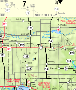
Historical
Maps
- Jewell County Map, KDOT
- Kansas Highway Map, KDOT
- Kansas Railroad Map, KDOT
- Kansas School District Boundary Map, KSDE