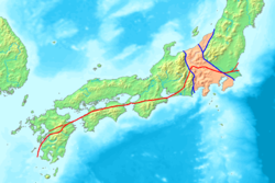
Japan Median Tectonic Line
Encyclopedia

Itoigawa-Shizuoka Tectonic Line
, also Ito Shizu Sen is a major fault on Honshu island that runs from the city of Itoigawa, Niigata Prefecture, through Lake Suwa to the city of Shizuoka in Shizuoka Prefecture. It is often confused with Fossa Magna which lies to the east....
(ISTL), the left blue line on the map, and the Fossa Magna, the pink shaded region.
The MTL begins near Ibaraki Prefecture
Ibaraki Prefecture
is a prefecture of Japan, located in the Kantō region on the main island of Honshu. The capital is Mito.-History:Ibaraki Prefecture was previously known as Hitachi Province...
, runs through central Honshū to near Nagoya, passing through Mikawa Bay
Mikawa Bay
thumb|right|Mikawa Bay Mikawa Bay is a bay to the south of Aichi Prefecture, Japan, surrounded by Chita Peninsula to the west and Atsumi Peninsula to the east and south. Its area is approximately 604 km2...
, then through the Inland Sea from the Kii Channel
Kii Channel
The is a strait separating the Japanese Home Islands of Honshū and Shikoku. This channel connects the Inland Sea with the Pacific Ocean....
and Naruto Strait
Naruto Strait
is a strait between Awaji Island and Shikoku in Japan. It connects Harima nada, the eastern part of the Inland Sea and Kii Channel. A famous feature of the strait is the Naruto whirlpools. Ōnaruto Bridge, the southern part of Akashi-Kaikyo Bridge crosses over it....
to Shikoku
Shikoku
is the smallest and least populous of the four main islands of Japan, located south of Honshū and east of the island of Kyūshū. Its ancient names include Iyo-no-futana-shima , Iyo-shima , and Futana-shima...
along the Sadamisaki Peninsula
Sadamisaki Peninsula
The is the westernmost part of the island of Shikoku, and is the narrowest peninsula in Japan. It is covered by the town of Ikata, Ehime Prefecture, and is home to the Ikata Nuclear Power Plant....
and the Bungo Channel
Bungo Channel
The is a strait separating the Japanese islands of Kyūshū and Shikoku. It connects the Pacific Ocean and Seto Inland Sea. The narrowest part of this channel is the Hōyo Strait....
and Hōyo Strait
Hoyo Strait
The is the strait at the narrowest part of the Bungo Channel in Japan....
to Kyūshū
Kyushu
is the third largest island of Japan and most southwesterly of its four main islands. Its alternate ancient names include , , and . The historical regional name is referred to Kyushu and its surrounding islands....
.

