

Sadamisaki Peninsula
Encyclopedia
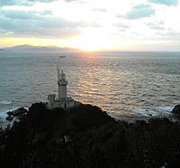
Shikoku
is the smallest and least populous of the four main islands of Japan, located south of Honshū and east of the island of Kyūshū. Its ancient names include Iyo-no-futana-shima , Iyo-shima , and Futana-shima...
, and is the narrowest peninsula
Peninsula
A peninsula is a piece of land that is bordered by water on three sides but connected to mainland. In many Germanic and Celtic languages and also in Baltic, Slavic and Hungarian, peninsulas are called "half-islands"....
in Japan
Japan
Japan is an island nation in East Asia. Located in the Pacific Ocean, it lies to the east of the Sea of Japan, China, North Korea, South Korea and Russia, stretching from the Sea of Okhotsk in the north to the East China Sea and Taiwan in the south...
. It is covered by the town of Ikata
Ikata, Ehime
is a small town located in Nishiuwa District, Ehime, Japan. Following a recent merger with the neighboring towns of Misaki and Seto, the town now spans the mountainous Sadamisaki Peninsula, the narrowest peninsula in Japan and the westernmost point on the island of Shikoku.This unique geography has...
, Ehime Prefecture
Ehime Prefecture
is a prefecture in northwestern Shikoku, Japan. The capital is Matsuyama.-History:Until the Meiji Restoration, Ehime prefecture was known as Iyo Province...
, and is home to the Ikata Nuclear Power Plant
Ikata Nuclear Power Plant
The is a nuclear power plant in the town of Ikata in the Nishiuwa District in Ehime Prefecture, Japan. It is the only nuclear plant on the island of Shikoku. It is owned and operated by the Shikoku Electric Power Company....
.
The peninsula is bounded to the north by the Inland Sea, to the south by the Uwa Sea (Pacific Ocean
Pacific Ocean
The Pacific Ocean is the largest of the Earth's oceanic divisions. It extends from the Arctic in the north to the Southern Ocean in the south, bounded by Asia and Australia in the west, and the Americas in the east.At 165.2 million square kilometres in area, this largest division of the World...
), and to the west by the Hōyo Strait
Hoyo Strait
The is the strait at the narrowest part of the Bungo Channel in Japan....
, which separates Shikoku
Shikoku
is the smallest and least populous of the four main islands of Japan, located south of Honshū and east of the island of Kyūshū. Its ancient names include Iyo-no-futana-shima , Iyo-shima , and Futana-shima...
from Kyūshū
Kyushu
is the third largest island of Japan and most southwesterly of its four main islands. Its alternate ancient names include , , and . The historical regional name is referred to Kyushu and its surrounding islands....
.
This combination of mountains and ocean make the Sadamisaki Peninsula a popular sightseeing destination, especially in the spring when the sakura
Sakura
A cherry blossom is the flower of any of several trees of genus Prunus, particularly the Japanese Cherry, Prunus serrulata, which is sometimes called sakura after the Japanese . Many of the varieties that have been cultivated for ornamental use do not produce fruit...
are in bloom.
Transportation
The Sadamisaki Peninsula is extremely mountainous. Until the completion of national highway Route 197, traversing the peninsula by car was quite inconvenient.Ferries run from Misaki Port at the tip of the peninsula to Beppu, Ōita
Beppu, Oita
is a city located in Ōita Prefecture on the island of Kyushu, Japan, at the west end of Beppu Bay. As of January 1, 2011, the city has an official population of 125,664 and a total area of 125.13 km², with a population density of 977 persons per km²....
and Saganoseki Port (Ōita, Ōita
Oita, Oita
is the capital city of Ōita Prefecture located on the island of Kyushu, Japan.- Demographics and geography :Ōita is the most populous city in Ōita Prefecture...
).
External links
- Seto Wind Hill Park webcams on the peninsula