
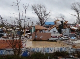
January 2008 tornado outbreak sequence
Encyclopedia
January 7 event
| List of reported tornadoes - Monday, January 7, 2008 | ||||||
|---|---|---|---|---|---|---|
Enhanced Fujita Scale The Enhanced Fujita Scale rates the strength of tornadoes in the United States based on the damage they cause.Implemented in place of the Fujita scale introduced in 1971 by Ted Fujita, it began operational use on February 1, 2007. The scale has the same basic design as the original Fujita scale:... |
|
|
|
|
|
|
| Missouri Missouri Missouri is a US state located in the Midwestern United States, bordered by Iowa, Illinois, Kentucky, Tennessee, Arkansas, Oklahoma, Kansas and Nebraska. With a 2010 population of 5,988,927, Missouri is the 18th most populous state in the nation and the fifth most populous in the Midwest. It... |
||||||
| EF0 | SW of Lowry City Lowry City, Missouri Lowry City is a city in St. Clair County, Missouri, United States. The population was 728 at the 2000 census, although the sign states 743. Lowry City is the city where the Ozark Mountains meet the Great Plains.-Geography:... |
St. Clair | 2022 | unknown | Brief tornado touchdown by spotter with damage to a few trees. | |
| EF0 | SE of Lincoln Lincoln, Missouri Lincoln is a city in Benton County, Missouri, United States. The population was 1,083 at the 2009 census.-Geography:Lincoln is located at .... |
Benton | 2054 | unknown | Report from a local newspaper. Photographs revealed that a pole barn was heavily damaged. | |
| EF0 | NE of Auxvasse Auxvasse, Missouri Auxvasse is a city in Callaway County, Missouri, United States. It is part of the Jefferson City, Missouri Metropolitan Statistical Area. The population was 983 at the 2010 census.-Geography:Auxvasse is located at .... |
Audrain Audrain County, Missouri Audrain County is a county located in the U.S. state of Missouri. As of 2010, the population was 25,529. Its county seat is Mexico. The county was organized in 1836. Audrain County was named for Col. James Hunter Audrain. Col. Audrain was Colonel of militia in the War of 1812. In 1830 Col... |
2155 | 0.5 mile (800 m) |
||
| EF2 | N of Purdy Purdy, Missouri Purdy is a city in Purdy Township, Barry County, Missouri, United States. The population was 1,103 at the 2000 census.-Geography:Purdy is located at .... |
Barry Barry County, Missouri Barry County is a county located in the U.S. state of Missouri. As of 2010, the population was 35,597. Its county seat is Cassville. The county was organized in 1835 and named after William Taylor Barry from Kentucky, a United States Postmaster General.... |
2306 | 12 miles (19.2 km) |
Damage reported by Monett Police at the corner of Route BB and Route 37. Tornado destroyed a barn and part of a mobile home park. | |
| EF0 | E of Pineville Pineville, Missouri Pineville is a city in and the county seat of McDonald County, Missouri, United States. The population was 916 at the 2009 census, at which time it was a town. It is part of the Fayetteville–Springdale–Rogers, AR-MO Metropolitan Statistical Area.... |
McDonald McDonald County, Missouri McDonald County is a county located in Southwest Missouri in the United States of America. As of the 2010 U.S. Census, the population was 23,083. Its county seat is Pineville... |
2350 | 0.1 mile (160 m) |
Minimal damage, primarily to trees. | |
| EF2 | SW of Republic Republic, Missouri Republic is a city in Christian and Greene counties in the U.S. state of Missouri. The population is 14,751 according to the 2010 United States Census. It is part of the Springfield, Missouri, Metropolitan Statistical Area.-History:... |
Greene Greene County, Missouri Greene County is a county located in Southwest Missouri. As of 2010, the population was 275,174 making it the fourth most populated county in Missouri. Its county seat is Springfield... |
2357 | 6 miles (9.6 km) |
A pole barn was destroyed. Numerous homes, as well as an elementary school Elementary school An elementary school or primary school is an institution where children receive the first stage of compulsory education known as elementary or primary education. Elementary school is the preferred term in some countries, particularly those in North America, where the terms grade school and grammar... , were badly damaged. Previously were two separate tornado tracks before being combined into a single track. |
|
| EF0 | W of Purdy Purdy, Missouri Purdy is a city in Purdy Township, Barry County, Missouri, United States. The population was 1,103 at the 2000 census.-Geography:Purdy is located at .... (1st tornado) |
Barry Barry County, Missouri Barry County is a county located in the U.S. state of Missouri. As of 2010, the population was 35,597. Its county seat is Cassville. The county was organized in 1835 and named after William Taylor Barry from Kentucky, a United States Postmaster General.... |
0020 | 0.1 mile (160 m) |
Brief tornado destroyed a mobile home. | |
| EF0 | W of Purdy Purdy, Missouri Purdy is a city in Purdy Township, Barry County, Missouri, United States. The population was 1,103 at the 2000 census.-Geography:Purdy is located at .... (2nd tornado) |
Barry Barry County, Missouri Barry County is a county located in the U.S. state of Missouri. As of 2010, the population was 35,597. Its county seat is Cassville. The county was organized in 1835 and named after William Taylor Barry from Kentucky, a United States Postmaster General.... |
0020 | 0.1 mile (160 m) |
Another brief tornado touchdown destroyed a pole barn. | |
| EF0 | W of Purdy Purdy, Missouri Purdy is a city in Purdy Township, Barry County, Missouri, United States. The population was 1,103 at the 2000 census.-Geography:Purdy is located at .... (3rd tornado) |
Barry Barry County, Missouri Barry County is a county located in the U.S. state of Missouri. As of 2010, the population was 35,597. Its county seat is Cassville. The county was organized in 1835 and named after William Taylor Barry from Kentucky, a United States Postmaster General.... |
0020 | 0.5 mile (800 m) |
Third tornado in the same area destroyed a barn. | |
| EF3 | Strafford Strafford, Missouri Strafford is a city in eastern Greene County, Missouri, United States. The population is 2,211 at the 2009 census, a small 2% of the population is African American and only .5% is Hispanic. It is part of the Springfield, Missouri Metropolitan Statistical Area... area (1st tornado) |
Greene Greene County, Missouri Greene County is a county located in Southwest Missouri. As of 2010, the population was 275,174 making it the fourth most populated county in Missouri. Its county seat is Springfield... , Webster Webster County, Missouri Webster County is a county located in Southwest Missouri. As of 2000, the population was 31,045. The population in 2010 was 36,202. Its county seat is Marshfield. The county was organized in 1855 and named for U.S. Senator and U.S... , Laclede Laclede County, Missouri Laclede County is a county located in the U.S. state of Missouri. As of 2000, the population was 32,513. Its county seat is Lebanon. The county was organized February 24, 1849, and was named after Pierre Laclède, founder of St... |
0029 | 26 miles (42 km) |
3 deaths - Over 50 houses were damaged or destroyed, along with many barns and outbuildings. Fatalities occurred near Strafford and Sampson Sampson, Missouri Sampson is a ghost town in Webster County, Missouri, United States, along the former U.S. Route 66. The current location is at the intersection of Missouri Supplemental Routes CC and H about ten miles northeast of Marshfield.... . Six others were injured. |
|
| EF0 | NE of Aurora Aurora, Missouri Aurora is a city in Lawrence County, Missouri, United States. The population was 7,014 at the 2000 census.-History:Between 1911 and 1920, the virulently Anti-Catholic newspaper The Menace was published in Aurora by W. F Phelps and Earl McClure... |
Lawrence, Christian Christian County, Missouri Christian County is a county located in Southwest Missouri. The county had a population of 54,285 in 2000 census. According to the 2010 census, the county's population is 77,422 , making it the fastest growing county in Missouri and one of the fastest growing in the nation as the county becomes... |
0128 | 6 miles (9.6 km) |
Heavy damage to a barn where a cow was killed. Farm houses and outbuildings were also damaged. | |
| EF2 | Strafford Strafford, Missouri Strafford is a city in eastern Greene County, Missouri, United States. The population is 2,211 at the 2009 census, a small 2% of the population is African American and only .5% is Hispanic. It is part of the Springfield, Missouri Metropolitan Statistical Area... area (2nd tornado) |
Greene Greene County, Missouri Greene County is a county located in Southwest Missouri. As of 2010, the population was 275,174 making it the fourth most populated county in Missouri. Its county seat is Springfield... , Webster Webster County, Missouri Webster County is a county located in Southwest Missouri. As of 2000, the population was 31,045. The population in 2010 was 36,202. Its county seat is Marshfield. The county was organized in 1855 and named for U.S. Senator and U.S... |
0132 | 17 miles (29 km) |
Power flashes reported. Several houses and outbuildings were damaged or destroyed. | |
| EF0 | S of Mount Sterling Mount Sterling, Missouri Mount Sterling is an unincorporated community in western Gasconade County, Missouri, United States.-Location:Mount Sterling is located at the intersection of U.S. Route 50 and Missouri Route A. The Gasconade River runs through the town, from south to north... |
Gasconade Gasconade County, Missouri Gasconade County is a county in the U.S. state of Missouri located on the south side of the Missouri River, which once served as the chief route of transportation in the state. Located in the area called the Missouri Rhineland, the county had a population of 15,342 as of the 2000 U.S. Census. A... |
0150 | 0.25 mile (400 m) |
Brief tornado touchdown with some tree damage. | |
| EF3 | Jerome Jerome, Missouri Jerome is an unincorporated community in western Phelps County, Missouri. It is located on Gasconade River near Interstate 44 and is about ten miles west of Rolla near the edge of the Mark Twain National Forest... area |
Pulaski Pulaski County, Missouri Pulaski County is a county located in the U.S. state of Missouri. The county was organized in 1833 and named for Kazimierz Pułaski, Polish patriot who died fighting in the American Revolution. As of 2010, the population was 52,274, an increase of 27% from the 2000 Census count of 41,165. Its... , Phelps Phelps County, Missouri Phelps County is a county located in south-central Missouri in the United States.According to the U.S. Census Bureau, it includes the mean center of U.S. population in 2000. As of the 2000 U.S. Census, the county's population was 39,825. A 2008 estimate, however, showed the population to be 42,205.... |
0206 | 7 miles (11 km) |
Significant damage reported in the area with numerous buildings destroyed, including several houses. Extensive tree damage in the area. Three people were injured. | |
| EF1 | NW of Mayflower | McDonald McDonald County, Missouri McDonald County is a county located in Southwest Missouri in the United States of America. As of the 2010 U.S. Census, the population was 23,083. Its county seat is Pineville... , Barry Barry County, Missouri Barry County is a county located in the U.S. state of Missouri. As of 2010, the population was 35,597. Its county seat is Cassville. The county was organized in 1835 and named after William Taylor Barry from Kentucky, a United States Postmaster General.... |
0215 | 7 miles (11.2 km) |
A few structures were heavily damaged or destroyed. Several trees were damaged. | |
| EF0 | W of Clarksville Clarksville, Missouri Clarksville is a city in Pike County, Missouri, United States. The population was 490 at the 2000 census.-Geography:... |
Pike Pike County, Missouri As of the census of 2010, there were 18,516 people, 6,451 households, and 4,476 families residing in the county. The population density was 27 people per square mile . There were 7,493 housing units at an average density of 11 per square mile... |
0230 | 5 miles (8 km) |
Intermittent tornado touchdown with some tree damage. | |
| EF1 | NE of Marshfield Marshfield, Missouri Marshfield is a city in Webster County, Missouri, United States. The population was 6,633 at the 2010 census. It is the county seat and part of the Springfield, Missouri Metropolitan Statistical Area.- History :... |
Webster Webster County, Missouri Webster County is a county located in Southwest Missouri. As of 2000, the population was 31,045. The population in 2010 was 36,202. Its county seat is Marshfield. The county was organized in 1855 and named for U.S. Senator and U.S... , Dallas |
0242 | 6 miles (9.6 km) |
One house was damaged along with a few outbuildings. | |
| EF2 | NW of Phillipsburg Phillipsburg, Missouri Phillipsburg is a village in Laclede County, Missouri, United States. The population was 201 at the 2000 census.-Geography:Phillipsburg is located at .... |
Laclede Laclede County, Missouri Laclede County is a county located in the U.S. state of Missouri. As of 2000, the population was 32,513. Its county seat is Lebanon. The county was organized February 24, 1849, and was named after Pierre Laclède, founder of St... |
0300 | 5 miles (8 km) |
Several outbuildings were destroyed and one house was heavily damaged. Numerous trees were uprooted. | |
| EF0 | W of Seligman Seligman, Missouri Seligman is a city in Sugar Creek Township, Barry County, Missouri, United States. The population was 877 at the 2000 census. The town is named after Joseph Seligman, a prominent 19th Century businessman.-Geography:... |
Barry Barry County, Missouri Barry County is a county located in the U.S. state of Missouri. As of 2010, the population was 35,597. Its county seat is Cassville. The county was organized in 1835 and named after William Taylor Barry from Kentucky, a United States Postmaster General.... |
0312 | 20 yds (18 m) |
Very short-lived tornado knocked a few trees down. | |
| EF1 | NW of Highlandville Highlandville, Missouri Highlandville is a city in Christian County, Missouri, United States. The population was 970 at the 2009 census. It is part of the Springfield, Missouri Metropolitan Statistical Area.-Geography:Highlandville is located at .... |
Christian Christian County, Missouri Christian County is a county located in Southwest Missouri. The county had a population of 54,285 in 2000 census. According to the 2010 census, the county's population is 77,422 , making it the fastest growing county in Missouri and one of the fastest growing in the nation as the county becomes... |
0336 | 1.5 miles (2.4 km) |
Two mobile homes were destroyed and several houses were damaged. One person was injured. | |
| EF1 | Vichy Vichy, Missouri Vichy is an unincorporated community in southern Maries County, Missouri, United States. It is located on U.S. Route 63 about ten miles north of Rolla. The community was founded in 1880 and is named after Vichy, France. The Rolla National Airport, a former U.S... area |
Phelps Phelps County, Missouri Phelps County is a county located in south-central Missouri in the United States.According to the U.S. Census Bureau, it includes the mean center of U.S. population in 2000. As of the 2000 U.S. Census, the county's population was 39,825. A 2008 estimate, however, showed the population to be 42,205.... , Maries |
0340 | 13 miles (21 km) |
10 houses were damaged, along with an unoccupied school building. Over 20 outbuildings were damaged or destroyed, and a mobile home was also destroyed. The Vichy recording station reported wind gusts of 97 mph (155 km/h). One person was injured. | |
| EF0 | E of Marshfield Marshfield, Missouri Marshfield is a city in Webster County, Missouri, United States. The population was 6,633 at the 2010 census. It is the county seat and part of the Springfield, Missouri Metropolitan Statistical Area.- History :... |
Webster Webster County, Missouri Webster County is a county located in Southwest Missouri. As of 2000, the population was 31,045. The population in 2010 was 36,202. Its county seat is Marshfield. The county was organized in 1855 and named for U.S. Senator and U.S... |
0357 | 11 miles (17 km) |
A mobile home lost its roof and a barn was destroyed. | |
| EF1 | W of Washburn Washburn, Missouri Washburn is a city in Washburn Township, Barry County, Missouri, United States. The population was 448 at the 2000 census.-Geography:Washburn is located at .... |
McDonald McDonald County, Missouri McDonald County is a county located in Southwest Missouri in the United States of America. As of the 2010 U.S. Census, the population was 23,083. Its county seat is Pineville... , Barry Barry County, Missouri Barry County is a county located in the U.S. state of Missouri. As of 2010, the population was 35,597. Its county seat is Cassville. The county was organized in 1835 and named after William Taylor Barry from Kentucky, a United States Postmaster General.... |
0421 | 9 miles (15 km) |
Damage limited to trees. | |
| Illinois Illinois Illinois is the fifth-most populous state of the United States of America, and is often noted for being a microcosm of the entire country. With Chicago in the northeast, small industrial cities and great agricultural productivity in central and northern Illinois, and natural resources like coal,... |
||||||
| EF3 | Lawrence Lawrence, Illinois Lawrence is an unincorporated community in McHenry County, Illinois, United States. Lawrence is northwest of Harvard.... area |
Boone, McHenry McHenry County, Illinois McHenry County is a county located in the U.S. state of Illinois. According to the 2010 census, it has a population of 308,760, which is an increase of 18.7% from 260,077 in 2000. Its county seat is Woodstock. This county is part of the Chicago metropolitan area. It is the sixth largest county, in... |
2130 | 13.2 miles (21 km) |
Seventeen homes, and several barns were destroyed and many other buildings were damaged. live stock were killed and several injured, The tornado also derailed a train on the Union Pacific Railroad Union Pacific Railroad The Union Pacific Railroad , headquartered in Omaha, Nebraska, is the largest railroad network in the United States. James R. Young is president, CEO and Chairman.... carrying hazardous materials Dangerous goods Dangerous goods are solids, liquids, or gases that can harm people, other living organisms, property, or the environment. They are often subject to chemical regulations. "HazMat teams" are personnel specially trained to handle dangerous goods... , forcing a local evacuation. Five people were injured. It was the first tornado in northeastern Illinois in the month of January since 1950. The derailment of the train was recorded by the trains on-board surveillance box camera. |
|
| EF1 | S of Mackinaw Mackinaw, Illinois Mackinaw is a village in Tazewell County, Illinois, United States. The population was 1,452 at the 2000 census. Mackinaw is part of the Peoria, Illinois Metropolitan Statistical Area.-Geography:Mackinaw is located at .... |
Tazewell Tazewell County, Illinois Tazewell County is a county located in the U.S. state of Illinois. According to the 2010 census, it has a population of 135,394, which is an increase of 5.4% from 128,485 in 2000. Its county seat and largest city is Pekin. The majority of the population live in the suburbs and bedroom communities... |
2322 | 3 miles (4.8 km) |
A pole barn was destroyed and a home and a few outbuildings were damaged. A chain link fence and tree limbs were blown down. | |
| EF0 | SE of Pleasant Hill Pleasant Hill, Illinois Pleasant Hill is a village in Pike County, Illinois, United States. The population was 1,047 at the 2000 census.Pleasant Hill is the site of the annual Pike County Fair, as well as the location of the Bi-State Annual Demolition Derby, which was previously held at Six Flags St... |
Pike Pike County, Illinois Pike County is a county located in the U.S. state of Illinois. According to the 2010 census, it has a population of 16,430, which is a decrease of 5.5% from 17,384 in 2000... |
0240 | 2.75 miles (4.4 km) |
Intermittent tornado touchdown with some tree damage. | |
| Wisconsin Wisconsin Wisconsin is a U.S. state located in the north-central United States and is part of the Midwest. It is bordered by Minnesota to the west, Iowa to the southwest, Illinois to the south, Lake Michigan to the east, Michigan to the northeast, and Lake Superior to the north. Wisconsin's capital is... |
||||||
| EF3 | New Munster New Munster, Wisconsin New Munster is an unincorporated community in the Town of Wheatland in Kenosha County, Wisconsin, United States.-Notes:... area |
Walworth Walworth County, Wisconsin Walworth County is a county located in the U.S. state of Wisconsin. As of 2010, the population was 102,228. Its county seat is Elkhorn.-Geography:According to the U.S... , Kenosha Kenosha County, Wisconsin -Demographics: As of the census of 2000, there were 149,577 people, 56,057 households, and 38,455 families residing in the county. The population density was 548 people per square mile . There were 59,989 housing units at an average density of 220 per square mile... |
2202 | 10.8 miles (17 km) |
The northernmost January tornado in the US since 1967 damaged over 150 houses, including 27 houses completely destroyed, with a few weaker structures flattened, and 32 others heavily damaged. 15 people were injured but no injuries were serious. | |
| EF1 | Kenosha Kenosha, Wisconsin Kenosha is a city and the county seat of Kenosha County in the State of Wisconsin in United States. With a population of 99,218 as of May 2011, Kenosha is the fourth-largest city in Wisconsin. Kenosha is also the fourth-largest city on the western shore of Lake Michigan, following Chicago,... |
Kenosha Kenosha County, Wisconsin -Demographics: As of the census of 2000, there were 149,577 people, 56,057 households, and 38,455 families residing in the county. The population density was 548 people per square mile . There were 59,989 housing units at an average density of 220 per square mile... |
2239 | 2.4 miles (3.9 km) |
Tornado damaged an apartment building in the northern fringes of the city, in which the second story suffered damage. Several houses suffered minor to moderate damage and some trees damaged. | |
| Arkansas Arkansas Arkansas is a state located in the southern region of the United States. Its name is an Algonquian name of the Quapaw Indians. Arkansas shares borders with six states , and its eastern border is largely defined by the Mississippi River... |
||||||
| EF0 | S of Hiwasse Hiwasse, Arkansas Hiwasse is an unincorporated census-designated place in Benton County, Arkansas, United States. As of the 2010 census, its population is 497. It is the location of Hiwasse Bank Building, which is located at Main St., AR 279 and Banks House, which is located on AR 72 west of Hiwasse... |
Benton Benton County, Arkansas Benton County is a county located in the U.S. state of Arkansas. As of the 2000 census, the population was 153,406. The U.S. Census Bureau 2010 population is 221,339. The county seat is Bentonville. Benton County was formed on 30 September 1836 and was named after Thomas Hart Benton, a U.S... |
0205 | unknown | ||
| EF0 | E of Centerton Centerton, Arkansas Centerton is a city in Benton County, Arkansas, United States. The population was 9,515 at the 2010 census. A tornado destroyed 40 homes, damaged 150, and injured 12 people on March 12, 2006... |
Benton Benton County, Arkansas Benton County is a county located in the U.S. state of Arkansas. As of the 2000 census, the population was 153,406. The U.S. Census Bureau 2010 population is 221,339. The county seat is Bentonville. Benton County was formed on 30 September 1836 and was named after Thomas Hart Benton, a U.S... |
0250 | unknown | ||
| EF1 | SW of Decatur Decatur, Arkansas Decatur is a city, in Benton County, Arkansas, United States. The population was 1,699 at the 2010 census. It is part of the Fayetteville–Springdale–Rogers, AR-MO Metropolitan Statistical Area... |
Benton Benton County, Arkansas Benton County is a county located in the U.S. state of Arkansas. As of the 2000 census, the population was 153,406. The U.S. Census Bureau 2010 population is 221,339. The county seat is Bentonville. Benton County was formed on 30 September 1836 and was named after Thomas Hart Benton, a U.S... |
0509 | 2.6 miles (4.2 km) |
Several trees heavily damaged, but no buildings impacted. | |
| Oklahoma Oklahoma Oklahoma is a state located in the South Central region of the United States of America. With an estimated 3,751,351 residents as of the 2010 census and a land area of 68,667 square miles , Oklahoma is the 28th most populous and 20th-largest state... |
||||||
| EF0 | SW of Watts Watts, Oklahoma Watts is a town in Adair County, Oklahoma, United States. The population was 316 at the 2000 census.-Geography:Watts is located at .According to the United States Census Bureau, the town has a total area of , all of it land.... |
Adair Adair County, Oklahoma Adair County is a county located in the U.S. state of Oklahoma. As of 2000, the population was 22,638. Its county seat is Stilwell. Adair County was named after the Adair family of the Cherokee tribe.-History:... |
0208 | unknown | ||
| EF0 | N of Moodys | Cherokee Cherokee County, Oklahoma Cherokee County is a county located in the U.S. state of Oklahoma. As of 2000, the population was 42,521. Its county seat is Tahlequah.Cherokee County was established in 1907.-Geography:... |
0428 | unknown | Brief touchdown resulted in minor damage to one house and two barns. | |
| EF0 | NE of Porter Porter, Oklahoma Porter is a town in Wagoner County, Oklahoma, United States. The population was 574 at the 2000 census.-Geography:Porter is located at .According to the United States Census Bureau, the town has a total area of , all of it land.... |
Wagoner Wagoner County, Oklahoma Wagoner County is a county located in the U.S. state of Oklahoma. As of 2010, the population was 73,085. Its county seat is Wagoner.-Early History:The area of Wagoner County was settled by the Creek after their forced removal in Alabama in the 1820's... |
0538 | 1 miles (1.6 km) |
Extensive tree damage. | |
| EF0 | NE of Wagoner Wagoner, Oklahoma Wagoner is a city in Wagoner County, Oklahoma, United States. The population was 7,669 at the 2000 census. It is the county seat of Wagoner County.-Geography:Wagoner is located at .... |
Wagoner Wagoner County, Oklahoma Wagoner County is a county located in the U.S. state of Oklahoma. As of 2010, the population was 73,085. Its county seat is Wagoner.-Early History:The area of Wagoner County was settled by the Creek after their forced removal in Alabama in the 1820's... |
0554 | 2.7 miles (4.4 km) |
Damage limited to a few trees. | |
| Sources: Storm reports of January 7, 2008, NWS Milwaukee, NWS Springfield, KY3 News, NWS Chicago, NWS St. Louis, NWS Tulsa |
||||||
January 8 event
| List of reported tornadoes - Tuesday, January 8, 2008 | ||||||
|---|---|---|---|---|---|---|
Enhanced Fujita Scale The Enhanced Fujita Scale rates the strength of tornadoes in the United States based on the damage they cause.Implemented in place of the Fujita scale introduced in 1971 by Ted Fujita, it began operational use on February 1, 2007. The scale has the same basic design as the original Fujita scale:... |
|
|
|
|
|
|
| Missouri Missouri Missouri is a US state located in the Midwestern United States, bordered by Iowa, Illinois, Kentucky, Tennessee, Arkansas, Oklahoma, Kansas and Nebraska. With a 2010 population of 5,988,927, Missouri is the 18th most populous state in the nation and the fifth most populous in the Midwest. It... |
||||||
| EF1 | NE of Washburn Washburn, Missouri Washburn is a city in Washburn Township, Barry County, Missouri, United States. The population was 448 at the 2000 census.-Geography:Washburn is located at .... |
Barry Barry County, Missouri Barry County is a county located in the U.S. state of Missouri. As of 2010, the population was 35,597. Its county seat is Cassville. The county was organized in 1835 and named after William Taylor Barry from Kentucky, a United States Postmaster General.... |
0822 | 7 miles (11 km) |
Several structures and trees damaged. | |
| EF1 | E of Cassville Cassville, Missouri Cassville is a city in Flat Creek Township, Barry County, Missouri, United States. The population was 3,266 at the 2010 census. It is the county seat of Barry County. Crowder College offers 2 year degree programs in Cassville... |
Barry Barry County, Missouri Barry County is a county located in the U.S. state of Missouri. As of 2010, the population was 35,597. Its county seat is Cassville. The county was organized in 1835 and named after William Taylor Barry from Kentucky, a United States Postmaster General.... , Stone Stone County, Missouri Stone County is a county located in Southwest Missouri in the United States. As of the 2010 U.S. Census, the county's population was 32,202. Its county seat is Galena... |
0831 | 14 miles (22 km) |
Several poultry barns were damaged, along with numerous sheds and outbuildings. | |
| EF1 | Springfield Springfield, Missouri Springfield is the third largest city in the U.S. state of Missouri and the county seat of Greene County. According to the 2010 census data, the population was 159,498, an increase of 5.2% since the 2000 census. The Springfield Metropolitan Area, population 436,712, includes the counties of... |
Greene Greene County, Missouri Greene County is a county located in Southwest Missouri. As of 2010, the population was 275,174 making it the fourth most populated county in Missouri. Its county seat is Springfield... |
0837 | 1 mile (1.6 km) |
Spotter reported tornado on the ground in central Springfield that moved across the northern part of the downtown area near Chestnut Expressway and Sherman Avenue. A warehouse owned by the Harry S. Cooper Supply Company collapsed. | |
| EF1 | Highlandville Highlandville, Missouri Highlandville is a city in Christian County, Missouri, United States. The population was 970 at the 2009 census. It is part of the Springfield, Missouri Metropolitan Statistical Area.-Geography:Highlandville is located at .... |
Christian Christian County, Missouri Christian County is a county located in Southwest Missouri. The county had a population of 54,285 in 2000 census. According to the 2010 census, the county's population is 77,422 , making it the fastest growing county in Missouri and one of the fastest growing in the nation as the county becomes... |
0850 | 5 miles (8 km) |
Tornado tracked through town damaging several roofs and destroying numerous outbuildings. | |
| EF0 | S of Branson Branson, Missouri Branson is a city in Taney County in the U.S. state of Missouri. It was named after Reuben Branson, postmaster and operator of a general store in the area in the 1880s.... |
Taney Taney County, Missouri Taney County is a county located in Southwest Missouri in the United States. As of the 2000 U.S. Census, the county's population was 39,703. In the 2010 census the counties population was 51,675 Its county seat is Forsyth.... |
0901 | 100 yds (90 m) |
Brief tornado touchdown in the Thousand Hills Resort. Three condominiums were damaged. | |
| EF0 | SW of Bracken to SW of Susanna | Webster Webster County, Missouri Webster County is a county located in Southwest Missouri. As of 2000, the population was 31,045. The population in 2010 was 36,202. Its county seat is Marshfield. The county was organized in 1855 and named for U.S. Senator and U.S... |
0916 | 7 miles (11.2 km) |
Weak tree and structure damage | |
| EF0 | SW of Tigris to SE of Mount Zion | Douglas Douglas County, Missouri Douglas County is a county located in South Central Missouri in the United States. As of the 2010 U.S. Census, the county's population was 13,684. The largest city and county seat is Ava. The county was officially organized on October 29, 1857, and is named after U.S. Senator Stephen A... |
0917 | 10 miles (16 km) |
Barns and outbuildings were damaged or destroyed | |
| EF2 | S of Niangua Niangua, Missouri Niangua is a city in Webster County, Missouri, United States. The population was 494 at the 2009 census. It lies three miles from Interstate 44 and five miles north of Marshfield.Niangua is part of the Springfield, Missouri Metropolitan Statistical Area.... |
Webster Webster County, Missouri Webster County is a county located in Southwest Missouri. As of 2000, the population was 31,045. The population in 2010 was 36,202. Its county seat is Marshfield. The county was organized in 1855 and named for U.S. Senator and U.S... |
0918 | 5 miles (8 km) |
Several homes and outbuildings were destroyed | |
| EF1 | SW of Mountain Grove Mountain Grove, Missouri Mountain Grove is a city in Texas and Wright Counties in the U.S. state of Missouri, located in south central Missouri. The population was 4,574 at the 2000 census.-Geography:Mountain Grove is located at... |
Douglas Douglas County, Missouri Douglas County is a county located in South Central Missouri in the United States. As of the 2010 U.S. Census, the county's population was 13,684. The largest city and county seat is Ava. The county was officially organized on October 29, 1857, and is named after U.S. Senator Stephen A... |
0943 | 1.5 miles (2.4 km) |
One mobile home was torn from its foundation. A barn and some outbuildings were damaged. Significant tree damage. | |
| EF1 | SE of Dawson to SE of Bado | Wright Wright County, Missouri Wright County is a county located in South Central Missouri in the United States. As of the 2010 U.S. Census, the county's population was 18,815. Its county seat is Hartville. The county was officially organized on January 29, 1841, and is named after Silas Wright , a former Congressman, U.S... , Texas Texas County, Missouri Texas County is a county located in South Central Missouri in the United States. As of the 2010 census, the county's population was 26,008. It's county seat is Houston. The county was organized in 1843 as Ashley County, changing its name in 1845 to Texas, after the Republic of Texas. The 2010 U.S... |
0945 | 12 miles (19.2 km) |
A few barns and outbuildings were damaged | |
| EF0 | W of West Plains West Plains, Missouri West Plains is a city in Howell County, Missouri, United States. The population was 10,866 at the 2000 census. It is the county seat of Howell County. The West Plains Micropolitan Statistical Area consists of Howell County.-Geography:... |
Howell Howell County, Missouri Howell County is a county located in South Central Missouri in the United States. As of the 2010 U.S. Census, the county's population was 40,400. The largest city and county seat is West Plains... |
1020 | unknown | Brief tornado touchdown reported. | |
| EF1 | SW of Eminence Eminence, Missouri Eminence is a city in Shannon County, Missouri, United States. The population was 600 at the time of the 2010 census. It is the county seat of Shannon County.-Geography:... |
Shannon Shannon County, Missouri Shannon County is a county located in South Central Missouri in the United States, and the second-largest by area in Missouri. As of the 2000 U.S. Census, the county's population was 8,324. A 2008 estimate, however, showed the population to be 8,423. Its county seat is Eminence. The county was... |
1027 | 1.5 miles (2.4 km) |
Numerous trees were snapped or uprooted, but no structures impacted. | |
| EF1 | NE of Eminence Eminence, Missouri Eminence is a city in Shannon County, Missouri, United States. The population was 600 at the time of the 2010 census. It is the county seat of Shannon County.-Geography:... |
Shannon Shannon County, Missouri Shannon County is a county located in South Central Missouri in the United States, and the second-largest by area in Missouri. As of the 2000 U.S. Census, the county's population was 8,324. A 2008 estimate, however, showed the population to be 8,423. Its county seat is Eminence. The county was... |
1038 | 10 miles (16 km) |
Two barns and a garage were destroyed, and another barn was damaged. Widespread tree damage. Initially were two separate tornado tracks | |
| EF0 | SW of Alton Alton, Missouri Alton is the county seat of Oregon County, Missouri, United States. The population was 668 at the 2000 census.-Geography:Alton is located at . According to the United States Census Bureau, the city has a total area of , all land.... |
Oregon Oregon County, Missouri Oregon County is a county located in South Central Missouri in the United States. As of the 2000 U.S. Census, the county's population was 10,344. A 2008 estimate, however, showed the population to be 10,264. Its county seat is Alton... |
1059 | 1 mile (1.6 km) |
Significant damage reported to three industrial buildings along Route 19. | |
| EF1 | NE of Essex Essex, Missouri Essex is a city in Stoddard County, Missouri, United States. The population was 524 at the 2000 census.-Geography:Essex is located at , six miles east of Dexter.... |
Stoddard Stoddard County, Missouri Stoddard County is a county located in Southeast Missouri in the United States. As of the 2000 U.S. Census, the population was 29,705. A 2008 estimate, however, showed the population to be 29,537. The county seat is Bloomfield while the largest city in the county is Dexter... |
1840 | 4.2 miles (6.8 km) |
A shed and three outbuildings destroyed and a house was damaged. About 10 power poles snapped. | |
| Arkansas Arkansas Arkansas is a state located in the southern region of the United States. Its name is an Algonquian name of the Quapaw Indians. Arkansas shares borders with six states , and its eastern border is largely defined by the Mississippi River... |
||||||
| EF2 | Appleton Appleton, Arkansas Appleton, Arkansas is an unincorporated community in Griffin Township, Pope County, Arkansas, United States.The town contained a post office from 1879 until 1968. It was named for an apple orchard that surrounded an early drug store.... area |
Pope, Conway, Van Buren | 1440 | 20.5 miles (33 km) |
1 death - Major structural damage reported in the area, with 10 houses destroyed and about 40 others damaged. Many other buildings were damaged or destroyed, including a church. Significant tree damage also reported. Two others were injured by the tornado. | |
| EF0 | SE of Princedale to SE of Twist Twist, Arkansas Twist is an unincorporated community in Cross County, Arkansas, USA.Twist was mentioned in the B.B. King song "Lucille" as the location of a club where he once played. It was at this club in Twist where a woman named Lucille started a fight which set the place on fire... |
Cross | 1926 | 11 miles (17.6 km) |
A mobile home lost its roof, farm water rig pivots were blown over and trees and power lines were knocked down | |
| EF1 | S of Deckerville | Poinsett | 1952 | 250 yds (225 m) |
Brief touchdown damaged two houses and destroyed a shed. | |
| EF1 | S of Osceola Osceola, Arkansas -Notable natives & residents:* Bill Alexander, U.S. Representative from First Congressional District, 1969–1993* David Barrett, New York Jets cornerback* Maurice Carthon, former NFL and USFL player and NFL assistant coach... |
Mississippi | 2020 | 3.5 miles (5.6 km) |
Several houses sustained roof damaged. Several people were trapped but rescued. | |
| Tennessee Tennessee Tennessee is a U.S. state located in the Southeastern United States. It has a population of 6,346,105, making it the nation's 17th-largest state by population, and covers , making it the 36th-largest by total land area... |
||||||
| EF1 | Poplar Grove area | Lauderdale, Dyer | 2058 | 7 miles (11 km) |
Several houses were severely damaged and one mobile home was destroyed. Extensive tree damage. | |
| Mississippi Mississippi Mississippi is a U.S. state located in the Southern United States. Jackson is the state capital and largest city. The name of the state derives from the Mississippi River, which flows along its western boundary, whose name comes from the Ojibwe word misi-ziibi... |
||||||
| EF0 | S of Church Hill Church Hill, Mississippi Church Hill is a small unincorporated community in Jefferson County, Mississippi, United States. It is located on the bluffs of the Mississippi River, approximately 18 miles north of Natchez. The geographic features are different from those in the rest of the state; there are high and steep bluffs... |
Jefferson Jefferson County, Mississippi -National protected areas:* Homochitto National Forest * Natchez Trace Parkway -Demographics:As of the census of 2000, there were 9,740 people, 3,308 households, and 2,338 families residing in the county. The population density was 19 people per square mile . There were 3,819 housing units at an... |
2130 | 4 miles (6.4 km) |
Tornado remained in a rural area but tree damage reported along the Natchez Trace Parkway Natchez Trace Parkway The Natchez Trace Parkway is a National Park Service unit in the southeastern United States that commemorates the historic Old Natchez Trace and preserves sections of the original trail.... . |
|
| EF1 | Harrisville Harrisville, Mississippi Harrisville is a small community located south of Florence, which is about 25 miles from Jackson in Simpson County, Mississippi, United States. It sits mainly on Highway 469 and connects to D'Lo and Pinola... area |
Simpson Simpson County, Mississippi -Demographics:As of the census of 2000, there were 27,639 people, 10,076 households, and 7,385 families residing in the county. The population density was 47 people per square mile . There were 11,307 housing units at an average density of 19 per square mile... |
2337 | 20 miles (32 km) |
Long-track tornado damaged several houses, including roofs blown off at least two houses. Widespread tree damage along the track. | |
| EF0 | SE of Puckett Puckett, Mississippi Puckett is a town/village in Rankin County, Mississippi, United States. The population was 354 at the 2000 census. It is part of the Jackson Metropolitan Statistical Area.-History:... |
Rankin Rankin County, Mississippi -Demographics:As of the census of 2000, there were 115,327 people, 42,089 households, and 31,145 families residing in the county. The population density was 149 people per square mile . There were 45,070 housing units at an average density of 58 per square mile... |
0011 | unknown | One house suffered shingle damage and some tree damage reported. | |
| Sources: Storm reports of January 8, 2008, NWS Little Rock, NWS Paducah, NWS Jackson (MS), NWS Memphis |
||||||
January 10 event
| List of reported tornadoes - Thursday, January 10, 2008 | ||||||
|---|---|---|---|---|---|---|
Enhanced Fujita Scale The Enhanced Fujita Scale rates the strength of tornadoes in the United States based on the damage they cause.Implemented in place of the Fujita scale introduced in 1971 by Ted Fujita, it began operational use on February 1, 2007. The scale has the same basic design as the original Fujita scale:... |
|
Parish |
|
|
|
|
| Mississippi Mississippi Mississippi is a U.S. state located in the Southern United States. Jackson is the state capital and largest city. The name of the state derives from the Mississippi River, which flows along its western boundary, whose name comes from the Ojibwe word misi-ziibi... |
||||||
| EF1 | SE of Rocky Springs Rocky Springs, Mississippi Rocky Springs, Mississippi is a ghost town and historic site located in Claiborne County, Mississippi, between Old Port Gibson Road and the Natchez Trace Parkway . The old town site can be viewed by the public during daylight hours... |
Claiborne Claiborne County, Mississippi -Demographics:As of the census of 2000, there were 11,831 people, 3,685 households, and 2,531 families residing in the county. The population density was 24 people per square mile . There were 4,252 housing units at an average density of 9 per square mile... |
1727 | 4 miles (6.4 km) |
Tornado remained in a rural area with heavy tree damage but no buildings impacted. | |
| EF3 | Goodman Goodman, Mississippi Goodman is a town in Holmes County, Mississippi, United States. The population was 1,252 at the 2000 census. It is the birthplace of John A. Lomax , pioneering folklorist, andDavid Herbert Donald , Pulitzer-prize-winning historian.... area |
Attala Attala County, Mississippi -Demographics:As of the census of 2000, there were 19,661 people, 7,567 households, and 5,380 families residing in the county. The population density was 27 people per square mile . There were 8,639 housing units at an average density of 12 per square mile... , Holmes Holmes County, Mississippi -National protected areas:*Hillside National Wildlife Refuge *Mathews Brake National Wildlife Refuge *Morgan Brake National Wildlife Refuge*Theodore Roosevelt National Wildlife Refuge -Demographics:... |
1751 | 10 miles (16 km) |
Damage reported to some homes in Goodman according to ABC 33/40 WBMA-LP WBMA-LD, channel 58, is the ABC television affiliate for Birmingham and central Alabama. Its transmitter is located in Birmingham, while its studio is in Hoover, a suburb of Birmingham.... coverage. Numerous houses damaged or destroyed, and hundreds of trees and powerlines down including high-tension towers by a 3/4 mile (1.2 km) wide wedge tornado. One person was injured. |
|
| EF3 | S of Ackerman Ackerman, Mississippi Ackerman is a town in Choctaw County, Mississippi, United States. The population was 1,696 at the 2000 census. It is the county seat of Choctaw County.It is named for an early landowner.-Geography:Ackerman is located at .... |
Attala Attala County, Mississippi -Demographics:As of the census of 2000, there were 19,661 people, 7,567 households, and 5,380 families residing in the county. The population density was 27 people per square mile . There were 8,639 housing units at an average density of 12 per square mile... , Choctaw Choctaw County, Mississippi -National protected areas:* Natchez Trace Parkway * Tombigbee National Forest -Demographics:As of the census of 2000, there were 9,758 people, 3,686 households, and 2,668 families residing in the county. The population density was 23 people per square mile . There were 4,249 housing units at an... |
1828 | 24 miles (38 km) |
Large wedge tornado destroyed one house, a cinder block structure, a dairy barn and several other structures. A trailer was lifted and flipped onto the roof of a farm building. Three people were injured. | |
| EF0 | N of Fannin | Rankin Rankin County, Mississippi -Demographics:As of the census of 2000, there were 115,327 people, 42,089 households, and 31,145 families residing in the county. The population density was 149 people per square mile . There were 45,070 housing units at an average density of 58 per square mile... |
1839 | 1.5 miles (2.4 km) |
Tornado damaged some pine trees. | |
| EF0 | SW of Pearl River Resort Pearl River Resort Pearl River Resort is a Native American-run resort located in Choctaw, Neshoba County, Mississippi. It is owned and operated by the Mississippi Band of Choctaw Indians.... |
Neshoba Neshoba County, Mississippi -Demographics:As of the census of 2000, there were 28,684 people, 10,694 households, and 7,742 families residing in the county. The population density was 50 people per square mile . There were 11,980 housing units at an average density of 21 per square mile... |
1942 | 2 miles (3.2 km) |
Two homes were damaged, one with porch damage and one with roof damage. | |
| EF1 | S of Iuka Iuka, Mississippi Iuka is a city in Tishomingo County, Mississippi, United States. The population was 3,059 at the 2000 census. It is the county seat of Tishomingo County. Woodall Mountain, the highest point in Mississippi, is located just south of Iuka.- History :... |
Tishomingo Tishomingo County, Mississippi As of the census of 2000 there were 19,163 people, 7,917 households, and 5,573 families residing in the county. The population density was 45 people per square mile . There were 9,553 housing units at an average density of 22 per square mile... |
1954 | 3.5 miles (5.6 km) |
Tornado touched down at a landfill Landfill A landfill site , is a site for the disposal of waste materials by burial and is the oldest form of waste treatment... site, then damaged two houses and two outbuildings and knocked down many trees. |
|
| EF3 | Caledonia Caledonia, Mississippi Caledonia is a town in Lowndes and Monroe Counties in the U.S. state of Mississippi. It is northeast of Columbus. The population was 1,015 at the 2000 census.-Geography:Caledonia is located at .... to NE of Malloy (AL) |
Lowndes Lowndes County, Mississippi As of the census of 2000, there were 61,586 people, 22,849 households, and 16,405 families residing in the county. The population density was 123 people per square mile . There were 25,104 housing units at an average density of 50 per square mile... , Lamar (AL) Lamar County, Alabama Lamar County is a county of the U.S. state of Alabama. Its name is in honor of Lucius Quintus Cincinnatus Lamar, member of the United States Senate from Mississippi. As of 2010 the population was 14,564... |
2013 | 14 miles (22.4 km) |
Major damage reported in Caledonia according to ABC 33/40 WBMA-LP WBMA-LD, channel 58, is the ABC television affiliate for Birmingham and central Alabama. Its transmitter is located in Birmingham, while its studio is in Hoover, a suburb of Birmingham.... coverage. A middle school Middle school Middle School and Junior High School are levels of schooling between elementary and high schools. Most school systems use one term or the other, not both. The terms are not interchangeable... gymnasium was destroyed, as well as several school buses and nearby houses. 10 people were injured. In Alabama, the tornado destroyed two barns, moved the foundations of two mobile homes and damaged two other homes. Initially was two separate tornado tracks with the other being a 5-mile EF2 north of Vernon in Lamar County. |
|
| EF1 | NW of Prairie Point | Noxubee Noxubee County, Mississippi -Demographics:As of the census of 2000, there were 12,548 people, 4,470 households, and 3,222 families residing in the county. The population density was 18 people per square mile . There were 5,228 housing units at an average density of 8 per square mile... |
2058 | 1.5 mile (2.4 km) |
Damage limited to downed power poles | |
| EF0 | N of Prairie Point | Noxubee Noxubee County, Mississippi -Demographics:As of the census of 2000, there were 12,548 people, 4,470 households, and 3,222 families residing in the county. The population density was 18 people per square mile . There were 5,228 housing units at an average density of 8 per square mile... |
2102 | 1 mile (1.6 km) |
Damage to a few trees | |
| Alabama Alabama Alabama is a state located in the southeastern region of the United States. It is bordered by Tennessee to the north, Georgia to the east, Florida and the Gulf of Mexico to the south, and Mississippi to the west. Alabama ranks 30th in total land area and ranks second in the size of its inland... |
||||||
| EF0 | Dixons Mills Dixons Mills, Alabama Dixons Mills is an unincorporated community in Marengo County, Alabama, United States. The community was named for a group of mills operated by Joel B. Dixon in the 19th century. Dixons Mills has a post office utilizing the 36736 ZIP code.-History:... |
Marengo Marengo County, Alabama Marengo County is a county of the U.S. state of Alabama. It is named in honor of a battlefield near Turin, Italy, where the French defeated the Austrians on June 14, 1800. As of 2010 the population was 21,027... |
1908 | 800 yds (750 m) |
Minor damage reported to four houses, and some trees knocked down. | |
| EF0 | Pickensville Pickensville, Alabama Pickensville is a town in Pickens County, Alabama, United States. At the 2000 census the population was 662.-Geography:Pickensville is located at .... |
Pickens Pickens County, Alabama Pickens County is a county of the U.S. state of Alabama. As of 2010, the population was 19,746. Its county seat is Carrollton, and it is a prohibition, or dry county.-History:... |
2140 | unknown | Brief tornado damaged the roof of a barn. | |
| EF1 | E of Gordo Gordo, Alabama Gordo is a town in Pickens County, Alabama, United States. At the 2000 census the population was 1,677.-Geography:Gordo is located at .... |
Pickens Pickens County, Alabama Pickens County is a county of the U.S. state of Alabama. As of 2010, the population was 19,746. Its county seat is Carrollton, and it is a prohibition, or dry county.-History:... , Tuscaloosa Tuscaloosa County, Alabama Tuscaloosa County is a county of the U.S. state of Alabama.It is named in honor of the pre-Choctaw chief Tuskaloosa. In 2010, the population was 194,656... |
2145 | 1.76 miles (2.8 km) |
One barn was destroyed and numerous chicken houses were damaged. | |
| EF3 | E of Windham Springs Windham Springs, Alabama Windham Springs is a small unincorporated community in northeastern Tuscaloosa County, Alabama west of the Jefferson - Walker county line. Near Windham Springs, there is the WTTO Tower, a guyed TV mast, which is one of the tallest constructions on earth.... |
Jefferson Jefferson County, Alabama Jefferson County is the most populous county in the U.S. state of Alabama, with its county seat being located in Birmingham.As of the 2010 U.S. Census, the population of Jefferson County was 658,466... , Walker Walker County, Alabama Walker County is a county of the U.S. state of Alabama.Its name is in honor of John Williams Walker, a member of the United States Senate. As of 2010 the population was 67,023... |
2220 | 4.9 miles (7.8 km) |
Tornado reported on the ground according to ABC 33/40 WBMA-LP WBMA-LD, channel 58, is the ABC television affiliate for Birmingham and central Alabama. Its transmitter is located in Birmingham, while its studio is in Hoover, a suburb of Birmingham.... coverage. It touched down west of Oak Grove Hueytown, Alabama Hueytown is a city in Jefferson County, Alabama, United States. At the 2010 census the population was 16,105.It was the home of the legendary NASCAR Alabama Gang... . Significant damage to trees, homes, a grocery store and a church. |
|
| Louisiana Louisiana Louisiana is a state located in the southern region of the United States of America. Its capital is Baton Rouge and largest city is New Orleans. Louisiana is the only state in the U.S. with political subdivisions termed parishes, which are local governments equivalent to counties... |
||||||
| EF1 | W of New Roads New Roads, Louisiana New Roads is a city in and the parish seat of Pointe Coupee Parish, Louisiana, United States. The center of population of Louisiana is located in New Roads . The population was 4,996 at the 2000 census. The city's ZIP code is 70760... |
Pointe Coupee Pointe Coupee Parish, Louisiana Pointe Coupee Parish, pronounced "Pwent Koo-Pay" and , is a parish located in the U.S. state of Louisiana. The parish seat is New Roads. As of 2000, the population was 22,763.... |
1910 | 0.25 mile (400 m) |
Brief tornado with minor to moderate damage at several industrial buildings at the intersection of Highways 1 Louisiana Highway 1 Louisiana Highway 1 is a state highway in Louisiana. At 436.20 miles , it is the longest numbered highway of any class in Louisiana. It runs diagonally across the state, connecting the oil and gas fields near the island of Grand Isle with the northwest corner of the state, north of Shreveport.The... and 3131 Louisiana Highway 3131 Louisiana Highway 3131 is a state highway in Louisiana that serves Pointe Coupee Parish. It spans in a south to north direction, and is located completely within the city limits of New Roads. It is known locally as Hospital Road, due to its close proximity to Pointe Coupee General Hospital. ... . |
|
| Kentucky Kentucky The Commonwealth of Kentucky is a state located in the East Central United States of America. As classified by the United States Census Bureau, Kentucky is a Southern state, more specifically in the East South Central region. Kentucky is one of four U.S. states constituted as a commonwealth... |
||||||
| EF1 | SW of Park City Park City, Kentucky Park City is a city in Barren County, Kentucky, United States. The population was 517 at the 2000 census. It has historically served as a gateway to nearby Mammoth Cave National Park and Diamond Caverns, a privately-owned cave attraction.... |
Barren Barren County, Kentucky As of the census of 2000, there were 38,033 people, 15,346 households, and 10,941 families residing in the county. The population density was . There were 17,095 housing units at an average density of... |
2002 | 1.8 miles (3 km) |
Tornado sighted just outside the town. | |
| Tennessee Tennessee Tennessee is a U.S. state located in the Southeastern United States. It has a population of 6,346,105, making it the nation's 17th-largest state by population, and covers , making it the 36th-largest by total land area... |
||||||
| EF2 | E of Waynesboro Waynesboro, Tennessee Waynesboro is a city in and the county seat of Wayne County, Tennessee, United States. The population was 2,449 at the 2010 census.-Geography:Waynesboro is located at .... |
Wayne Wayne County, Tennessee As of the census of 2010, there were 17,021 people, 5,822 households, and 4,321 families residing in the county. The population density was 23 people per square mile . There were 6,701 housing units at an average density of 9 per square mile... |
2055 | 1.29 miles (2.1 km) |
A metal barn was completely destroyed and several others suffered heavy damage. Minor damage to a few houses. | |
| Sources: Storm reports of January 10, 2008 NWS Birmingham, NWS New Orleans, NWS Jackson (MS), NWS Jackson (MS) Preliminary Storm Report, NWS Nashville, NWS Louisvlle |
||||||
January 11 event
| List of reported tornadoes - Friday, January 11, 2008 | ||||||
|---|---|---|---|---|---|---|
Enhanced Fujita Scale The Enhanced Fujita Scale rates the strength of tornadoes in the United States based on the damage they cause.Implemented in place of the Fujita scale introduced in 1971 by Ted Fujita, it began operational use on February 1, 2007. The scale has the same basic design as the original Fujita scale:... |
|
Parish |
|
|
|
|
| Alabama Alabama Alabama is a state located in the southeastern region of the United States. It is bordered by Tennessee to the north, Georgia to the east, Florida and the Gulf of Mexico to the south, and Mississippi to the west. Alabama ranks 30th in total land area and ranks second in the size of its inland... |
||||||
| EF1 | S of Blue Springs Blue Springs, Alabama Blue Springs is a town in Barbour County, Alabama, United States. At the 2000 census the population was 121. According to the 2005 U.S. Census estimates, the town had a population of 118. -Geography:... |
Barbour Barbour County, Alabama Barbour County, Alabama is a county of the U.S. state of Alabama. Its name is in honor of James Barbour, who served as Governor of Virginia. As of 2010 the population was 27,457. Its county seat is Clayton.-History:... |
0700 | 3.5 miles (5.6 km) |
Late report found in surveys on February 19 while repairs were underway. Four houses and a mobile home were damaged, and trees were damaged in the area. | |
| Sources: NWS Birmingham |
||||||
Non-tornadic events
Michigan
Michigan is a U.S. state located in the Great Lakes Region of the United States of America. The name Michigan is the French form of the Ojibwa word mishigamaa, meaning "large water" or "large lake"....
to Missouri as well as dense fog across Wisconsin, Ontario and Quebec
Quebec
Quebec or is a province in east-central Canada. It is the only Canadian province with a predominantly French-speaking population and the only one whose sole official language is French at the provincial level....
which was caused by rapid snow melt stemming from the January thaw. flooding was reported across several towns and roads which forced the evacuation of some residents. Record-breaking temperatures were reported all across Southern Ontario and surrounding areas. The thick fog lead to numerous accidents including two pile-ups involving in total 100 vehicles on Interstate 90
Interstate 90
Interstate 90 is the longest Interstate Highway in the United States at . It is the northernmost coast-to-coast interstate, and parallels US 20 for the most part. Its western terminus is in Seattle, at Edgar Martinez Drive S. near Safeco Field and CenturyLink Field, and its eastern terminus is in...
near Madison, Wisconsin
Madison, Wisconsin
Madison is the capital of the U.S. state of Wisconsin and the county seat of Dane County. It is also home to the University of Wisconsin–Madison....
which killed at least two and injured dozens more while additional fatal accidents occurred elsewhere. It also disrupted air travel across several airports. Rainfall had exceeded locally 4 inches (100 mm) of rain from Missouri to Indiana and Michigan.
High winds and rain have battered Central, southern and eastern Ontario and southern and central Quebec on January 8, and 9. Power outages and wind damages were reported in some areas. As much as 140,000 Hydro One
Hydro One
Hydro One Incorporated delivers electricity across the Canadian province of Ontario. It is a Corporation established under the Business Corporations Act with a single shareholder, the Government of Ontario....
customers were without power in Ontario and at least 100,000 Hydro-Québec
Hydro-Québec
Hydro-Québec is a government-owned public utility established in 1944 by the Government of Quebec. Based in Montreal, the company is in charge of the generation, transmission and distribution of electricity across Quebec....
customers in Quebec. Winds were gusting in near on in excess of 100 km/h in some localities including the Greater Toronto Area
Greater Toronto Area
The Greater Toronto Area is the largest metropolitan area in Canada, with a 2006 census population of 5.5 million. The Greater Toronto Area is usually defined as the central city of Toronto, along with four regional municipalities surrounding it: Durham, Halton, Peel, and York...
while the highest peak being 133 km/h recorded near Sandbanks Provincial Park
Sandbanks Provincial Park
Sandbanks Provincial Park is a provincial park located on Lake Ontario in Prince Edward County near Picton, Ontario, Canada. It is noted for its picturesque sand dunes and beaches. It also has the world's largest fresh water sand bar and dune system.Sandbanks is run...
in Prince Edward County
Prince Edward County, Ontario
Prince Edward County is a single-tier municipality and a census division of the Canadian province of Ontario.-Geography:Prince Edward County is located in Southern Ontario on a large irregular headland or littoral at the eastern end of Lake Ontario, just west of the head of the St. Lawrence River...
. One tractor trailer was overturned and nearly fell into the Saint Lawrence River
Saint Lawrence River
The Saint Lawrence is a large river flowing approximately from southwest to northeast in the middle latitudes of North America, connecting the Great Lakes with the Atlantic Ocean. It is the primary drainage conveyor of the Great Lakes Basin...
on the Ogdensburg-Prescott International Bridge
Ogdensburg-Prescott International Bridge
The Ogdensburg–Prescott International Bridge, also known as the St. Lawrence Bridge and the Seaway Skyway, is a suspension bridge connecting Ogdensburg, New York in the United States to Johnstown, Ontario in Canada...
See also
- 1967 St. Louis tornado outbreak1967 St. Louis Tornado OutbreakThe 1967 St. Louis tornado outbreak was the rare winter outbreak that occurred on January 24, 1967. Thirty-two tornadoes broke out from Oklahoma to Wisconsin. Fourteen tornadoes struck Iowa, nine in Missouri, eight in Illinois, and one in Wisconsin....
- Similar rare tornado outbreak in January in the Midwest - List of North American tornadoes and tornado outbreaks
- List of tornadoes striking downtown areas
- Tornadoes of 2008Tornadoes of 2008This page documents the tornadoes and tornado outbreaks that occurred in 2008, primarily in the United States. Most tornadoes form in the U.S., although some events may take place internationally, particularly in parts of neighboring southern Canada during the Northern Hemisphere's summer season....
External links
- Rare January Tornado in Northern Illinois Monday Afternoon Rated EF3 (NWS Chicago)
- Pictures and Information For Rare January Tornadoes in Southeast Wisconsin (NWS Milwaukee)
- Severe Weather and Flooding of January 7-8, 2008 (NWS Lincoln IL)
- Summary of Severe Weather/Tornado Surveys January 7th-8th (NWS St. Louis)
- Unusually Early Severe Weather Outbreak Hits the Ozarks (NWS Springfield MO)
- Severe Weather on January 7-8, 2008 (NWS Little Rock)
- Jan 7-8 Severe Weather Event (NWS Tulsa)
- Overview of January 8 storms (NWS Paducah)
- Video of a train being derailed by a tornado near Harvard, IL (Youtube)