

Walworth County, Wisconsin
Encyclopedia
Walworth County is a county located in the U.S. state
of Wisconsin
. As of 2010, the population was 102,228. Its county seat
is Elkhorn
.
, the county has a total area of 576 square miles (1,491.8 km²), of which 555 square miles (1,437.4 km²) is land and 21 square miles (54.4 km²) (3.68%) is water.
As of the census
of 2000, there were 93,759 people, 34,522 households, and 23,267 families residing in the county. The population density
was 169 people per square mile (65/km²). There were 43,783 housing units at an average density of 79 per square mile (30/km²). The racial makeup of the county was 94.49% White
, 0.84% Black
or African American
, 0.23% Native American
, 0.65% Asian
, 0.03% Pacific Islander
, 2.62% from other races
, and 1.14% from two or more races. 6.54% of the population were Hispanic
or Latino
of any race.
There were 34,522 households out of which 31.80% had children under the age of 18 living with them, 55.40% were married couples
living together, 8.20% had a female householder with no husband present, and 32.60% were non-families. 24.70% of all households were made up of individuals and 9.20% had someone living alone who was 65 years of age or older. The average household size was 2.57 and the average family size was 3.07.
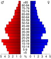
In the county, the population was spread out with 24.20% under the age of 18, 13.80% from 18 to 24, 27.60% from 25 to 44, 21.80% from 45 to 64, and 12.70% who were 65 years of age or older. The median age was 35 years. For every 100 females there were 98.90 males. For every 100 females age 18 and over, there were 97.20 males.
History
U.S. state
A U.S. state is any one of the 50 federated states of the United States of America that share sovereignty with the federal government. Because of this shared sovereignty, an American is a citizen both of the federal entity and of his or her state of domicile. Four states use the official title of...
of Wisconsin
Wisconsin
Wisconsin is a U.S. state located in the north-central United States and is part of the Midwest. It is bordered by Minnesota to the west, Iowa to the southwest, Illinois to the south, Lake Michigan to the east, Michigan to the northeast, and Lake Superior to the north. Wisconsin's capital is...
. As of 2010, the population was 102,228. Its county seat
County seat
A county seat is an administrative center, or seat of government, for a county or civil parish. The term is primarily used in the United States....
is Elkhorn
Elkhorn, Wisconsin
Elkhorn is a city in Walworth County, Wisconsin, United States. It is southwest of Milwaukee and northwest of Chicago. The population was 7,305 at the 2000 census. It is the county seat of Walworth County...
.
Geography
According to the U.S. Census BureauUnited States Census Bureau
The United States Census Bureau is the government agency that is responsible for the United States Census. It also gathers other national demographic and economic data...
, the county has a total area of 576 square miles (1,491.8 km²), of which 555 square miles (1,437.4 km²) is land and 21 square miles (54.4 km²) (3.68%) is water.
Major highways

 U.S. Highway 12
 U.S. Highway 14


Adjacent counties
Clockwise from north- Waukesha CountyWaukesha County, WisconsinWaukesha County is a county in the U.S. state of Wisconsin. As of 2008, the population was 380,629. Its county seat is Waukesha.-History:The part of Wisconsin that Waukesha County now occupies was a part of Michigan when Milwaukee County was organized in September 1834. On July 4, 1836, the...
(northeast) - Racine County (east)
- Kenosha CountyKenosha County, Wisconsin-Demographics: As of the census of 2000, there were 149,577 people, 56,057 households, and 38,455 families residing in the county. The population density was 548 people per square mile . There were 59,989 housing units at an average density of 220 per square mile...
(east) - McHenry County, IllinoisMcHenry County, IllinoisMcHenry County is a county located in the U.S. state of Illinois. According to the 2010 census, it has a population of 308,760, which is an increase of 18.7% from 260,077 in 2000. Its county seat is Woodstock. This county is part of the Chicago metropolitan area. It is the sixth largest county, in...
(southeast) - Boone County, Illinois (southwest)
- Rock CountyRock County, Wisconsin-Unincorporated communities:-Further reading:* . Chicago: Western Historical Company, 1879.* Brown, William F. , Chicago: Cooper, 1908.* Brown, William F. , Chicago: Cooper, 1908....
(west) - Jefferson CountyJefferson County, WisconsinJefferson County is a county located in the U.S. state of Wisconsin. As of 2000, the population was 74,021. Its county seat is Jefferson.-Geography:According to the U.S...
(northwest)
Demographics
As of the census
Census
A census is the procedure of systematically acquiring and recording information about the members of a given population. It is a regularly occurring and official count of a particular population. The term is used mostly in connection with national population and housing censuses; other common...
of 2000, there were 93,759 people, 34,522 households, and 23,267 families residing in the county. The population density
Population density
Population density is a measurement of population per unit area or unit volume. It is frequently applied to living organisms, and particularly to humans...
was 169 people per square mile (65/km²). There were 43,783 housing units at an average density of 79 per square mile (30/km²). The racial makeup of the county was 94.49% White
Race (United States Census)
Race and ethnicity in the United States Census, as defined by the Federal Office of Management and Budget and the United States Census Bureau, are self-identification data items in which residents choose the race or races with which they most closely identify, and indicate whether or not they are...
, 0.84% Black
Race (United States Census)
Race and ethnicity in the United States Census, as defined by the Federal Office of Management and Budget and the United States Census Bureau, are self-identification data items in which residents choose the race or races with which they most closely identify, and indicate whether or not they are...
or African American
Race (United States Census)
Race and ethnicity in the United States Census, as defined by the Federal Office of Management and Budget and the United States Census Bureau, are self-identification data items in which residents choose the race or races with which they most closely identify, and indicate whether or not they are...
, 0.23% Native American
Race (United States Census)
Race and ethnicity in the United States Census, as defined by the Federal Office of Management and Budget and the United States Census Bureau, are self-identification data items in which residents choose the race or races with which they most closely identify, and indicate whether or not they are...
, 0.65% Asian
Race (United States Census)
Race and ethnicity in the United States Census, as defined by the Federal Office of Management and Budget and the United States Census Bureau, are self-identification data items in which residents choose the race or races with which they most closely identify, and indicate whether or not they are...
, 0.03% Pacific Islander
Race (United States Census)
Race and ethnicity in the United States Census, as defined by the Federal Office of Management and Budget and the United States Census Bureau, are self-identification data items in which residents choose the race or races with which they most closely identify, and indicate whether or not they are...
, 2.62% from other races
Race (United States Census)
Race and ethnicity in the United States Census, as defined by the Federal Office of Management and Budget and the United States Census Bureau, are self-identification data items in which residents choose the race or races with which they most closely identify, and indicate whether or not they are...
, and 1.14% from two or more races. 6.54% of the population were Hispanic
Race (United States Census)
Race and ethnicity in the United States Census, as defined by the Federal Office of Management and Budget and the United States Census Bureau, are self-identification data items in which residents choose the race or races with which they most closely identify, and indicate whether or not they are...
or Latino
Race (United States Census)
Race and ethnicity in the United States Census, as defined by the Federal Office of Management and Budget and the United States Census Bureau, are self-identification data items in which residents choose the race or races with which they most closely identify, and indicate whether or not they are...
of any race.
There were 34,522 households out of which 31.80% had children under the age of 18 living with them, 55.40% were married couples
Marriage
Marriage is a social union or legal contract between people that creates kinship. It is an institution in which interpersonal relationships, usually intimate and sexual, are acknowledged in a variety of ways, depending on the culture or subculture in which it is found...
living together, 8.20% had a female householder with no husband present, and 32.60% were non-families. 24.70% of all households were made up of individuals and 9.20% had someone living alone who was 65 years of age or older. The average household size was 2.57 and the average family size was 3.07.
In the county, the population was spread out with 24.20% under the age of 18, 13.80% from 18 to 24, 27.60% from 25 to 44, 21.80% from 45 to 64, and 12.70% who were 65 years of age or older. The median age was 35 years. For every 100 females there were 98.90 males. For every 100 females age 18 and over, there were 97.20 males.
Cities, villages, and towns
- BloomfieldBloomfield, Walworth County, WisconsinBloomfield is a town in Walworth County, Wisconsin, United States. The population was 5,537 at the 2000 census. The census-designated places of Lake Ivanhoe and Pell Lake, Wisconsin are located in the town.-Geography:...
- BurlingtonBurlington, WisconsinBurlington is a city in Racine and Walworth counties in the U.S. state of Wisconsin, with the majority of the city located in Racine County. The population was 10,421 at the 2009 census.-History:...
(partial) - ComoComo, WisconsinComo is a census-designated place in Walworth County, Wisconsin, United States. The population was 2,631 at the 2010 census.-Geography:Como is located at ....
- Darien (town)Darien (town), WisconsinDarien is a town in Walworth County, Wisconsin, United States. The population was 1,747 at the 2000 census. The Village of Darien is located within the town...
- DarienDarien, WisconsinDarien is a village in Walworth County, Wisconsin, United States. It is pronounced or . The population was 1,572 at the 2000 census. The village is located within the Town of Darien.-Geography:Darien is located at ....
- Delavan (town)Delavan (town), WisconsinDelavan is a town in Walworth County, Wisconsin, United States. The City of Delavan is located partially within the town.-Geography:According to the United States Census Bureau, the town has a total area of 28.1 square miles , of which, 25.3 square miles of it is land and...
- DelavanDelavan, WisconsinDelavan is a city in Walworth County, Wisconsin, United States. The population was 8,463 at the 2010 census. The city is located partially within the Town of Delavan.-Economy:Delavan is home to the Wisconsin School for the Deaf, and Andes Candies.-History:...
- Delavan LakeDelavan Lake, WisconsinDelavan Lake is a census-designated place in Walworth County, Wisconsin, United States. The population was 2,649 at the 2010 census.-Geography:Delavan Lake is located at ....
- East Troy (town)East Troy (town), WisconsinEast Troy is a town in Walworth County, Wisconsin, United States. The population was 3,830 at the 2000 census.-Geography:According to the United States Census Bureau, the town has a total area of 32.1 square miles , of which, 30.3 square miles of it is land and 1.8 square miles of...
- East TroyEast Troy, WisconsinEast Troy is a village in Walworth County, Wisconsin, United States. The population was 3,564 at the 2000 census. The village is located southeast of the Town of East Troy. A small portion extends into the adjacent Town of Troy...
- ElkhornElkhorn, WisconsinElkhorn is a city in Walworth County, Wisconsin, United States. It is southwest of Milwaukee and northwest of Chicago. The population was 7,305 at the 2000 census. It is the county seat of Walworth County...
- Fontana-on-Geneva LakeFontana-on-Geneva Lake, WisconsinFontana-on-Geneva Lake is a village in Walworth County, Wisconsin, United States. The population was 1,754 at the 2000 census.-Geography:Fontana-on-Geneva Lake is located at ....
- GenevaGeneva, WisconsinGeneva is a town in Walworth County, Wisconsin, United States. The population was 4,099 at the 2000 census.-Geography:According to the United States Census Bureau, the town has a total area of 30.8 square miles , of which, 29.3 square miles of it is land and 1.5 square miles of it ...
- Genoa CityGenoa City, WisconsinGenoa City is a village located in Kenosha, and Walworth Counties in the U.S. state of Wisconsin, 43 miles south-southwest of Milwaukee. The population was 1,949 at the 2000 census....
(partial) - La GrangeLa Grange, Walworth County, WisconsinLa Grange is a town in Walworth County, Wisconsin, United States. The population was 2,444 at the 2000 census. The unincorporated community of Lauderdale Lakes is located in the town.-Geography:...
- LafayetteLafayette, Walworth County, WisconsinLafayette is a town in Walworth County, Wisconsin, United States. The population was 2,251 at the 2000 census.-Geography:According to the United States Census Bureau, the town has a total area of 34.5 square miles , of which, 34.5 square miles of it is land and 0.04 square miles of...
- Lake GenevaLake Geneva, WisconsinLake Geneva is a city in Walworth County, Wisconsin, United States. The population was 7,148 at the 2000 census. A resort city located on Geneva Lake, it is southwest of Milwaukee and popular with tourists from metropolitan Chicago and Milwaukee.-History:...
- LinnLinn, WisconsinLinn is a town in Walworth County, Wisconsin, United States. The population was 2,194 at the 2000 census. The unincorporated community of Zenda is located within the town.-Geography:...
- LyonsLyons, WisconsinLyons is a town in Walworth County, Wisconsin, United States. The population was 3,440 at the 2000 census. The unincorporated communities of Lyons, and Springfield are located within the town.-Geography:...
- MukwonagoMukwonago, Wisconsin-Geography:Mukwonago is located at .According to the United States Census Bureau, the village has a total area of 4.8 square miles , of which, 4.7 square miles of it is land and 0.1 square miles of it is water.It is situated at the southwestern flank of the sprawling Vernon...
(partial) - Pell LakePell Lake, WisconsinPell Lake is a census-designated place in Walworth County, Wisconsin, United States. The population was 3,722 at the 2010 census.-Geography:Pell Lake is located at ....
- Potter LakePotter Lake, WisconsinPotter Lake is a census-designated place in Walworth County, Wisconsin, United States. The population was 1,107 at the 2010 census.-Geography:Potter Lake is located at ....
- Powers LakePowers Lake, WisconsinPowers Lake is a census-designated place in Kenosha and Walworth Counties in the U.S. state of Wisconsin. As of the 2010 census, the CDP had a total population of 1,615.-Geography:...
- RichmondRichmond, Walworth County, WisconsinRichmond is a town in Walworth County, Wisconsin, in the United States. As of the 2000 census, the town population was 1,835. The unincorporated communities of Lake Lorraine and Turtle Lake are located in the town.-Geography:...
- Sharon (town)Sharon, Walworth County, WisconsinSharon is a town in Walworth County, Wisconsin, United States. The population was 912 at the 2000 census. The Village of Sharon is located within the town.-Geography:...
- SharonSharon, WisconsinSharon is a village in Walworth County, Wisconsin, United States. The population was 1,549 at the 2000 census. The village is located within the Town of Sharon.-Notable people:* Walter Samuel Goodland, Governor of Wisconsin, was born in Sharon....
- Spring PrairieSpring Prairie, WisconsinSpring Prairie is a town in Walworth County, Wisconsin, United States. The population was 2,089 at the 2000 census. The unincorporated communities of Honey Creek, and Voree are located in Spring Prairie.-Geography:...
- Sugar CreekSugar Creek, WisconsinSugar Creek is a town in Walworth County, Wisconsin, United States. The population was 3,331 at the 2000 census. The unincorporated community of Millard is located in the town.-Geography:...
- TroyTroy, Walworth County, WisconsinTroy is a town in Walworth County, Wisconsin, United States. The population was 2,328 at the 2000 census. The unincorporated communities of Troy, and Troy Center are located in the town.-Geography:...
- Walworth (town)Walworth (town), WisconsinWalworth is a town in Walworth County, Wisconsin, United States. The population was 1,676 at the 2000 census. The Village of Walworth is located within the town...
- WalworthWalworth, WisconsinWalworth is a village in Walworth County, Wisconsin, United States. The population was 2,304 at the 2000 census. The village is located within the Town of Walworth.-Geography:Walworth is located at ....
- Whitewater (town)Whitewater (town), WisconsinWhitewater is a town in Walworth County, Wisconsin, United States. The population was 1,399 at the 2000 census.-Geography:According to the United States Census Bureau, the town has a total area of 30.6 square miles , of which, 29.6 square miles of it is land and 1.0 square miles of...
- Whitewater (partial)
- Williams BayWilliams Bay, WisconsinWilliams Bay is a village in Walworth County, Wisconsin, United States. The population was 2,415 at the 2000 census.-Geography:Williams Bay is located at ....
Unincorporated communities
- Allen's GroveAllen's Grove, WisconsinAllen's Grove is an unincorporated community in Walworth County, Wisconsin, United States. It is located approximately two miles west of Darien, Wisconsin, in the town of Darien, at .-History:...
- Big Foot PrairieBig Foot Prairie, Illinois and WisconsinBig Foot Prairie is an unincorporated community in both McHenry County, Illinois and Walworth County, Wisconsin in the United States. The Illinois portion of the community, which is larger, is located in Chemung Township, while the Wisconsin portion is located in the Town of Walworth. Big Foot...
(partial) - Honey CreekHoney Creek, Walworth County, WisconsinHoney Creek is an unincorporated community in the town of Spring Prairie, Wisconsin. It is on the northeastern border of Walworth County, Wisconsin at latitude 42°44'45"N and longitude 88°18'28" W. The population is approximately 400.- History :...
- Lake IvanhoeLake Ivanhoe, WisconsinLake Ivanhoe is a census-designated place in the town of Bloomfield, Walworth County, Wisconsin, United States. Its population was 435 as of the 2010 census....
- Lake LorraineLake Lorraine, WisconsinLake Lorraine is a census-designated place in the town of Richmond, Walworth County, Wisconsin, United States. Its population was 324 as of the 2010 census....
- Lauderdale LakesLauderdale Lakes, WisconsinLauderdale Lakes is a census-designated place in the town of La Grange, Walworth County, Wisconsin, United States. Its population was 1,172 as of the 2010 census....
- LyonsLyons (community), WisconsinLyons is an unincorporated community located in the town of Lyons, in Walworth County, Wisconsin, United States. Lyons is located on Wisconsin Highway 36 west-southwest of Burlington. Lyons has a post office with ZIP code 53148....
- MillardMillard, WisconsinMillard is an unincorporated community located in the town of Sugar Creek, Walworth County, Wisconsin, United States....
- SpringfieldSpringfield, Walworth County, WisconsinSpringfield is an unincorporated census-designated place in the town of Lyons, in Walworth County, Wisconsin, United States. As of the 2010 census, its population is 158. Located just northeast of Lake Geneva, it contains a mere eight streets. Springfield has an area of , all of it...
- TroyTroy (community), Walworth County, WisconsinTroy is an unincorporated community located in the town of Troy, in Walworth County, Wisconsin, United States. Troy is west-southwest of East Troy....
- Troy CenterTroy Center, WisconsinTroy Center is an unincorporated community located in the town of Troy, in Walworth County, Wisconsin, United States. Troy Center is west-northwest of East Troy....
- Turtle LakeTurtle Lake, Walworth County, WisconsinTurtle Lake is a census-designated place in the town of Richmond, Walworth County, Wisconsin, United States. Its population was 343 as of the 2010 census....
- VoreeVoree, WisconsinVoree is an unincorporated community on the outskirts of present-day Burlington, in Walworth County, Wisconsin, United States, in the town limits of Spring Prairie. It is best known as the historic and current headquarters of the Church of Jesus Christ of Latter Day Saints , a denomination of the...
- ZendaZenda, WisconsinZenda is an unincorporated community in the Town of Linn, Walworth County, Wisconsin, United States. It is located south of Lake Geneva and just north of the Illinois border. Its ZIP code is 53195.-History:...
External links
GeneralHistory