

Jameson Avenue
Encyclopedia
Parkdale, Toronto
Parkdale is a neighbourhood and former village in Toronto, Ontario, Canada, west of downtown. The neighbourhood is bounded on the west by Roncesvalles Avenue, on the north by Queen Street. It is bounded on the east by Dufferin Street from Queen Street south, and on the south by Lake Ontario...
neighbourhood in Toronto
Toronto
Toronto is the provincial capital of Ontario and the largest city in Canada. It is located in Southern Ontario on the northwestern shore of Lake Ontario. A relatively modern city, Toronto's history dates back to the late-18th century, when its land was first purchased by the British monarchy from...
, Ontario
Ontario
Ontario is a province of Canada, located in east-central Canada. It is Canada's most populous province and second largest in total area. It is home to the nation's most populous city, Toronto, and the nation's capital, Ottawa....
, Canada
Canada
Canada is a North American country consisting of ten provinces and three territories. Located in the northern part of the continent, it extends from the Atlantic Ocean in the east to the Pacific Ocean in the west, and northward into the Arctic Ocean...
. It is a north-south roadway from Lake Shore Boulevard to Queen Street
Queen Street West
Queen Street West describes both the western branch of Queen Street, a major east-west thoroughfare, and a series of neighbourhoods or commercial districts, situated west of Yonge Street in downtown Toronto, Ontario, Canada. Queen Street begins in the west at the intersection of King Street, The...
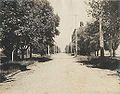
. Originally laid out in the 19th century as two-lane residential street, its traffic and land use has changed considerably from a suburban/semi-rural street to a main arterial connecting to an expressway
Limited-access road
A limited-access road known by various terms worldwide, including limited-access highway, dual-carriageway and expressway, is a highway or arterial road for high-speed traffic which has many or most characteristics of a controlled-access highway , including limited or no access to adjacent...
.
History
Jameson Avenue was built in the 1880s as part of the then Village of Parkdale's development, connecting Queen Street to the Lake OntarioLake Ontario
Lake Ontario is one of the five Great Lakes of North America. It is bounded on the north and southwest by the Canadian province of Ontario, and on the south by the American state of New York. Ontario, Canada's most populous province, was named for the lake. In the Wyandot language, ontarío means...
waterfront. Parkdale Collegiate Institute
Parkdale Collegiate Institute
Parkdale Collegiate Institute is a public high school located on Jameson Avenue in Toronto, Ontario, Canada. It was founded in 1888 in the community of Parkdale.-History:Parkdale High School opened in the Masonic Hall on Dowling Avenue in 1888...
, built in 1888 near Queen Street, was one of the first structures to rise alongside the street. Near the foot of the street at Springhurst Avenue and Jameson, the South Parkdale railway station
South Parkdale railway station
The South Parkdale railway station was a passenger rail station on the Grand Trunk Railway in Toronto, Ontario, Canada. It was located at Jameson Avenue and Springhurst Avenue in the former village of Parkdale. It was demolished in 1911 as part of a grade separation engineering project.-History:The...
was built in 1879, on the Grand Trunk Railway
Grand Trunk Railway
The Grand Trunk Railway was a railway system which operated in the Canadian provinces of Quebec and Ontario, as well as the American states of Connecticut, Maine, Michigan, Massachusetts, New Hampshire, and Vermont. The railway was operated from headquarters in Montreal, Quebec; however, corporate...
(GTR).
After the 1889 annexation of Parkdale into the City of Toronto, the pace of development increased around Jameson Avenue, and the street became lined with single-family dwellings, many of them quite large along the full length of the street down to the waterfront. Several still exist today.
The first change in the character of the street came in the 1910s, when the GTR lowered the level of the railway tracks to below that of Jameson, and closed the railway station, replacing it with the Sunnyside railway station
Sunnyside railway station
The Sunnyside railway station was a railway station in Toronto, Ontario, Canada, formerly located at King and Queen Streets. It operated passenger service from 1910 until 1971.-History:...
to the west.
As the City of Toronto grew, and the development of the suburbs to the west, east-west automobile traffic in the area increased. The completion of the Queen Elizabeth Way
Queen Elizabeth Way
The Queen Elizabeth Way, commonly abbreviated as the QEW, is a 400-Series highway in the Canadian province of Ontario. The freeway links Buffalo, New York and the Niagara Peninsula with Toronto. It begins at the Peace Bridge in Fort Erie and travels around the western shore of Lake Ontario, ending...
(QEW) in 1940 meant that Lake Shore Road, and by extension Parkdale, became a major connecting path between downtown Toronto and the highway. King and Queen Streets started to carry large amounts of commuter traffic. When the Municipality of Metropolitan Toronto was created in 1953, one of the first projects proposed was a connector highway between the QEW and downtown. This became the Gardiner Expressway
Gardiner Expressway
The Frederick G. Gardiner Expressway, colloquially referred to as "the Gardiner", is a municipal expressway in the Canadian province of Ontario, connecting downtown Toronto with its western suburbs...
. The Gardiner Expressway's right-of-way was laid out just south of the existing GTR rail lines, at the same level. This right-of-way meant the demolition of over 50 homes at the foot of Jameson. An interchange with the expressway at Jameson was also created, which eliminated pedestrian access to the waterfront from the neighbourhood, necessitating a pedestrian bridge.
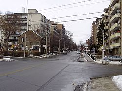
The building of the highway changed the street from a residential neighbourhood street to an arterial roadway. The land use changed considerably after that, from the single-family dwellings to the multi-storey apartment buildings that line Jameson on both sides from Springhurst to Queen Street today.
Recently, plans have been made to revamp the area of the demolished neighbourhood, moving the eastbound Lake Shore Boulevard to north of the Gardiner, freeing up space for park uses and enhancing access to the waterfront. As of July 2009, the project still requires approval and funding from Toronto City Council.