

Jackson County, Illinois
Encyclopedia
Jackson County, incorporated January 10, 1816, is a county located in the U.S. state
of Illinois
. According to the 2010 census, it has a population of 60,218, which is an increase of 1.0% from 59,612 in 2000. Its county seat
is Murphysboro
; its most populous city is Carbondale
, home to the main campus of Southern Illinois University
.
The Carbondale Micropolitan Statistical Area includes all of Jackson County.
has been conducted and is ongoing. Exploration from the European explorers began with the Joliet-Marquette
exploration along the Mississippi River
. It was not until the 18th and 19th century when pioneer farmers began to settle in the area's inexpensive land along the Mississippi River and in the forested Shawnee hills with its one-hundred-foot trees.
As early as 1813, Conrad Will (namesake of Will County
) conducted a large salt extraction operation, using slave labor, on the banks of the Big Muddy River
, south of Murphysboro. As this area was in the "free" Northwest Territory
, Will had to have legal exemptions to possess slaves.
Jackson County was organized in 1816, having been carved out of Randolph County
. It was named for Andrew Jackson
, who had just defeated the British at the Battle of New Orleans
.
Shortly after the American Civil War
, General John A. Logan
led a parade of veterans from Murphysboro to Carbondale
, Illinois
. General Logan, a Union veteran, invited the Confederate veterans, of which there were many in Jackson County, to march with him. Thus, what might have been another celebration of the Union victory became a memorial to the war dead on both sides. This is one version of the origin of the Memorial Day
holiday.
In 1925 the great Tri-State Tornado
ripped through Jackson County on March 18, leaving devastation in its path. The villages of Gorham and DeSoto and the city of Murphysboro were especially hit hard.
The county courthouse is located in downtown Murphysboro. The current reinforced concrete courthouse replaced earlier wooden structures and was built during 1927-28. The original county seat and courthouse were located along the Big Muddy River at Brownsville
. To afford a more strategic location after the courthouse in Brownsville was destroyed by fire, County government was moved upstream a few miles to Murphysboro. There are few traces of Brownsville still visible. On February 27, 1843, the Illinois General Assembly created a commission to designate a new county seat for Jackson County.
The first coal mine in Illinois was opened on the south bank of the Big Muddy River
near the present-day Route 127 Bridge.
and the city of Carbondale
. A rapidly developing city, it is part of the Metro Lakeland area consisting mainly of the major communities of Carbondale, Marion, Herrin, and Carterville. The outer regions of the Metro are include Murphysboro, the rest of Jackson County, the rest of Williamson County, Perry County, and Saline County. Jackson County is also located near the Shawnee Hills Wine Trail. Once a small business, the wine trail has evolved into a booming tourist attraction.
Several major roadways run through the county:
Illinois Routes 3, 149, 13, 127
U.S. Route 51
Illinois Route 3 runs from St. Louis to Cairo, connecting to Interstate 57 and Cape Girardeau, Missouri in between.
Illinois Route 149 runs East-West through the county connecting Illinois Route 3 and Interstate 57 in West Frankfort.
Illinois Route 13 connects to Interstate 57 fourteen miles (21 km) East of the county line, in Marion.
Illinois Route 127 connects to Interstate 64 thirty miles North of the county line, in Nashville, Illinois.
U.S. Route 51 runs North-South through the county and the heart of Carbondale. It connects to Interstate 57 south of Jackson County, in Union County, and to Interstate 64 north of Jackson County, in Washington County.
of 2000, there were 59,612 people, 24,215 households, and 12,664 families residing in the county. The population density
was 101 people per square mile (39/km²). There were 26,844 housing units at an average density of 46 per square mile (18/km²). The racial makeup of the county was 80.79% White
, 13.02% Black
or African American
, 0.31% Native American
, 3.03% Asian
, 0.06% Pacific Islander
, 1.00% from other races
, and 1.80% from two or more races. 2.42% of the population were Hispanic
or Latino
of any race. 22.0% were of German
, 10.0% Irish
, 9.4% American
and 8.6% English
ancestry according to Census 2000. 92.6% spoke English
and 2.7% Spanish
as their first language.
There were 24,215 households out of which 24.40% had children under the age of 18 living with them, 39.30% were married couples
living together, 9.70% had a female householder with no husband present, and 47.70% were non-families. 34.90% of all households were made up of individuals and 9.30% had someone living alone who was 65 years of age or older. The average household size was 2.21 and the average family size was 2.89.
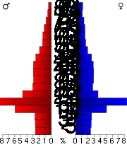
In the county the population was spread out with 19.30% under the age of 18, 26.00% from 18 to 24, 25.90% from 25 to 44, 17.90% from 45 to 64, and 11.00% who were 65 years of age or older. The median age was 28 years. For every 100 females there were 104.30 males. For every 100 females age 18 and over, there were 102.90 males.
The median income for a household in the county was $24,946, and the median income for a family was $40,950. Males had a median income of $31,910 versus $22,396 for females. The per capita income
for the county was $15,755. About 14.70% of families and 25.20% of the population were below the poverty line, including 23.00% of those under age 18 and 10.50% of those age 65 or over.
:
U.S. state
A U.S. state is any one of the 50 federated states of the United States of America that share sovereignty with the federal government. Because of this shared sovereignty, an American is a citizen both of the federal entity and of his or her state of domicile. Four states use the official title of...
of Illinois
Illinois
Illinois is the fifth-most populous state of the United States of America, and is often noted for being a microcosm of the entire country. With Chicago in the northeast, small industrial cities and great agricultural productivity in central and northern Illinois, and natural resources like coal,...
. According to the 2010 census, it has a population of 60,218, which is an increase of 1.0% from 59,612 in 2000. Its county seat
County seat
A county seat is an administrative center, or seat of government, for a county or civil parish. The term is primarily used in the United States....
is Murphysboro
Murphysboro, Illinois
Murphysboro is a city in and the county seat of Jackson County, Illinois, United States. The population was 7,970 at the 2010 census. The city is part of the Metro Lakeland area.-Geography:Murphysboro is located at ....
; its most populous city is Carbondale
Carbondale, Illinois
Carbondale is a city in Jackson County, in the state of Illinois, within the Southern Illinois region. It is located at the junction of Illinois Route 13 and U.S. Route 51, southeast of St. Louis, Missouri, on the northern edge of the Shawnee National Forest...
, home to the main campus of Southern Illinois University
Southern Illinois University Carbondale
Southern Illinois University Carbondale is a public research university located in Carbondale, Illinois, United States. Founded in 1869, SIUC is the flagship campus of the Southern Illinois University system...
.
The Carbondale Micropolitan Statistical Area includes all of Jackson County.
History
Human occupation of Jackson County began about 11,500 years ago. Extensive documentation of the areas indigenous peoplesNative Americans in the United States
Native Americans in the United States are the indigenous peoples in North America within the boundaries of the present-day continental United States, parts of Alaska, and the island state of Hawaii. They are composed of numerous, distinct tribes, states, and ethnic groups, many of which survive as...
has been conducted and is ongoing. Exploration from the European explorers began with the Joliet-Marquette
Jacques Marquette
Father Jacques Marquette S.J. , sometimes known as Père Marquette, was a French Jesuit missionary who founded Michigan's first European settlement, Sault Ste. Marie, and later founded St. Ignace, Michigan...
exploration along the Mississippi River
Mississippi River
The Mississippi River is the largest river system in North America. Flowing entirely in the United States, this river rises in western Minnesota and meanders slowly southwards for to the Mississippi River Delta at the Gulf of Mexico. With its many tributaries, the Mississippi's watershed drains...
. It was not until the 18th and 19th century when pioneer farmers began to settle in the area's inexpensive land along the Mississippi River and in the forested Shawnee hills with its one-hundred-foot trees.
As early as 1813, Conrad Will (namesake of Will County
Will County, Illinois
As of the census of 2000, there were 502,266 people, 167,542 households, and 131,017 families residing in the county. The population density was 600 people per square mile . There were 175,524 housing units at an average density of 210 per square mile...
) conducted a large salt extraction operation, using slave labor, on the banks of the Big Muddy River
Big Muddy River
The Big Muddy River is a river in southern Illinois. It joins the Mississippi River south of Murphysboro. The Big Muddy has been dammed near Benton, forming Rend Lake.The Big Muddy has a mud bottom for most of its length.-Hydrography:...
, south of Murphysboro. As this area was in the "free" Northwest Territory
Northwest Territory
The Territory Northwest of the River Ohio, more commonly known as the Northwest Territory, was an organized incorporated territory of the United States that existed from July 13, 1787, until March 1, 1803, when the southeastern portion of the territory was admitted to the Union as the state of Ohio...
, Will had to have legal exemptions to possess slaves.
Jackson County was organized in 1816, having been carved out of Randolph County
Randolph County, Illinois
Randolph County is a county located in the U.S. state of Illinois. According to the 2010 census, it has a population of 33,476, which is a decrease of 1.2% from 33,893 in 2000. Its county seat is Chester....
. It was named for Andrew Jackson
Andrew Jackson
Andrew Jackson was the seventh President of the United States . Based in frontier Tennessee, Jackson was a politician and army general who defeated the Creek Indians at the Battle of Horseshoe Bend , and the British at the Battle of New Orleans...
, who had just defeated the British at the Battle of New Orleans
Battle of New Orleans
The Battle of New Orleans took place on January 8, 1815 and was the final major battle of the War of 1812. American forces, commanded by Major General Andrew Jackson, defeated an invading British Army intent on seizing New Orleans and the vast territory the United States had acquired with the...
.
Shortly after the American Civil War
American Civil War
The American Civil War was a civil war fought in the United States of America. In response to the election of Abraham Lincoln as President of the United States, 11 southern slave states declared their secession from the United States and formed the Confederate States of America ; the other 25...
, General John A. Logan
John A. Logan
John Alexander Logan was an American soldier and political leader. He served in the Mexican-American War and was a general in the Union Army in the American Civil War. He served the state of Illinois as a state senator, congressman and senator and was an unsuccessful candidate for Vice President...
led a parade of veterans from Murphysboro to Carbondale
Carbondale, Illinois
Carbondale is a city in Jackson County, in the state of Illinois, within the Southern Illinois region. It is located at the junction of Illinois Route 13 and U.S. Route 51, southeast of St. Louis, Missouri, on the northern edge of the Shawnee National Forest...
, Illinois
Illinois
Illinois is the fifth-most populous state of the United States of America, and is often noted for being a microcosm of the entire country. With Chicago in the northeast, small industrial cities and great agricultural productivity in central and northern Illinois, and natural resources like coal,...
. General Logan, a Union veteran, invited the Confederate veterans, of which there were many in Jackson County, to march with him. Thus, what might have been another celebration of the Union victory became a memorial to the war dead on both sides. This is one version of the origin of the Memorial Day
Memorial Day
Memorial Day is a United States federal holiday observed on the last Monday of May. Formerly known as Decoration Day, it originated after the American Civil War to commemorate the fallen Union soldiers of the Civil War...
holiday.
In 1925 the great Tri-State Tornado
Tri-State Tornado
The Tri-State Tornado of Wednesday, March 18, 1925, was the deadliest tornado in U.S. history. With 695 confirmed fatalities, the tornado killed more than twice as many as the second deadliest, the 1840 Great Natchez Tornado...
ripped through Jackson County on March 18, leaving devastation in its path. The villages of Gorham and DeSoto and the city of Murphysboro were especially hit hard.
The county courthouse is located in downtown Murphysboro. The current reinforced concrete courthouse replaced earlier wooden structures and was built during 1927-28. The original county seat and courthouse were located along the Big Muddy River at Brownsville
Brownsville, Illinois
Brownsville, Illinois, is a ghost town in Southern Illinois.Brownsville, located where Kinkade Creek empties into the Big Muddy River, is the former county seat of Jackson County. It was abandoned when the courthouse burned to the ground in 1843, and the county seat was then moved to Murphysboro,...
. To afford a more strategic location after the courthouse in Brownsville was destroyed by fire, County government was moved upstream a few miles to Murphysboro. There are few traces of Brownsville still visible. On February 27, 1843, the Illinois General Assembly created a commission to designate a new county seat for Jackson County.
Geography
According to the 2010 census, the county has a total area of 602.38 square miles (1,560.2 km²), of which 584.08 square miles (1,512.8 km²) (or 96.96%) is land and 18.3 square miles (47.4 km²) (or 3.04%) is water. The average elevation is around 400 feet (121.9 m), except near the Mississippi River.The first coal mine in Illinois was opened on the south bank of the Big Muddy River
Big Muddy River
The Big Muddy River is a river in southern Illinois. It joins the Mississippi River south of Murphysboro. The Big Muddy has been dammed near Benton, forming Rend Lake.The Big Muddy has a mud bottom for most of its length.-Hydrography:...
near the present-day Route 127 Bridge.
Major highways
 U.S. Highway 51


Adjacent counties
- Perry County - north
- Franklin CountyFranklin County, IllinoisFranklin County is a county located in the U.S. state of Illinois. According to the 2010 census, it has a population of 39,561, which is an increase of 1.4% from 39,018 in 2000. Its county seat is Benton.-History:...
- northeast - Williamson CountyWilliamson County, Illinois-2010:Whereas according to the 2010 U.S. Census Bureau:*92.7% White*3.8% Black*0.4% Native American*0.8% Asian*0.0% Native Hawaiian or Pacific Islander*1.7% Two or more races*0.4% Other races*2.0% Hispanic or Latino -2000:...
- east - Union County - southeast
- Perry CountyPerry County, MissouriPerry County is a county located in Southeast Missouri in the United States. As of the 2000 U.S. Census, the county's population was 18,132. In 2008 the population was estimated to be 18,743. Its county seat is Perryville. The county was officially organized on November 16, 1820 from Ste...
, MissouriMissouriMissouri is a US state located in the Midwestern United States, bordered by Iowa, Illinois, Kentucky, Tennessee, Arkansas, Oklahoma, Kansas and Nebraska. With a 2010 population of 5,988,927, Missouri is the 18th most populous state in the nation and the fifth most populous in the Midwest. It...
- west - Randolph CountyRandolph County, IllinoisRandolph County is a county located in the U.S. state of Illinois. According to the 2010 census, it has a population of 33,476, which is a decrease of 1.2% from 33,893 in 2000. Its county seat is Chester....
- northwest
National protected areas
- Crab Orchard National Wildlife RefugeCrab Orchard National Wildlife RefugeCrab Orchard National Wildlife Refuge is a 43,890 acre National Wildlife Refuge primarily in southwestern Williamson County, but with small extensions into adjacent eastern Jackson and northeastern Union counties of southern Illinois, in the United States. Its land and water contain a wide...
(part) - Shawnee National ForestShawnee National ForestThe Shawnee National Forest, located in the Ozark and Shawnee Hills of Southern Illinois, consists of approximately 280,000 acres of federally managed lands. In descending order of land area it is located in parts of Pope, Jackson, Union, Hardin, Alexander, Saline, Gallatin, Johnson, and Massac...
(part)
Economic Development
Much of the county's economic situation is dependent upon Southern Illinois University CarbondaleSouthern Illinois University Carbondale
Southern Illinois University Carbondale is a public research university located in Carbondale, Illinois, United States. Founded in 1869, SIUC is the flagship campus of the Southern Illinois University system...
and the city of Carbondale
Carbondale, Illinois
Carbondale is a city in Jackson County, in the state of Illinois, within the Southern Illinois region. It is located at the junction of Illinois Route 13 and U.S. Route 51, southeast of St. Louis, Missouri, on the northern edge of the Shawnee National Forest...
. A rapidly developing city, it is part of the Metro Lakeland area consisting mainly of the major communities of Carbondale, Marion, Herrin, and Carterville. The outer regions of the Metro are include Murphysboro, the rest of Jackson County, the rest of Williamson County, Perry County, and Saline County. Jackson County is also located near the Shawnee Hills Wine Trail. Once a small business, the wine trail has evolved into a booming tourist attraction.
Several major roadways run through the county:
Illinois Routes 3, 149, 13, 127
U.S. Route 51
Illinois Route 3 runs from St. Louis to Cairo, connecting to Interstate 57 and Cape Girardeau, Missouri in between.
Illinois Route 149 runs East-West through the county connecting Illinois Route 3 and Interstate 57 in West Frankfort.
Illinois Route 13 connects to Interstate 57 fourteen miles (21 km) East of the county line, in Marion.
Illinois Route 127 connects to Interstate 64 thirty miles North of the county line, in Nashville, Illinois.
U.S. Route 51 runs North-South through the county and the heart of Carbondale. It connects to Interstate 57 south of Jackson County, in Union County, and to Interstate 64 north of Jackson County, in Washington County.
Demographics
2010
Whereas according to the 2010 U.S. Census Bureau:- 77.8% WhiteWhite AmericanWhite Americans are people of the United States who are considered or consider themselves White. The United States Census Bureau defines White people as those "having origins in any of the original peoples of Europe, the Middle East, or North Africa...
- 14.3% BlackAfrican AmericanAfrican Americans are citizens or residents of the United States who have at least partial ancestry from any of the native populations of Sub-Saharan Africa and are the direct descendants of enslaved Africans within the boundaries of the present United States...
- 0.4% Native AmericanNative Americans in the United StatesNative Americans in the United States are the indigenous peoples in North America within the boundaries of the present-day continental United States, parts of Alaska, and the island state of Hawaii. They are composed of numerous, distinct tribes, states, and ethnic groups, many of which survive as...
- 3.2% AsianAsian AmericanAsian Americans are Americans of Asian descent. The U.S. Census Bureau definition of Asians as "Asian” refers to a person having origins in any of the original peoples of the Far East, Southeast Asia, or the Indian subcontinent, including, for example, Cambodia, China, India, Indonesia, Japan,...
- 0.1% Native Hawaiian or Pacific IslanderPacific Islander AmericanPacific Islander Americans, also known as Oceanian Americans, are residents of the United States with original ancestry from Oceania. They represent the smallest racial group counted in the United States census of 2000. They numbered 874,000 people or 0.3 percent of the United States population...
- 2.6% Two or more racesMultiracial AmericanMultiracial Americans, US residents who identify themselves as of "two or more races", were numbered at around 9 million, or 2.9% of the population, in the census of 2010. However there is considerable evidence that the real number is far higher. Prior to the mid-20th century many people hid their...
- 1.6% Other racesRace (United States Census)Race and ethnicity in the United States Census, as defined by the Federal Office of Management and Budget and the United States Census Bureau, are self-identification data items in which residents choose the race or races with which they most closely identify, and indicate whether or not they are...
- 4.0% Hispanic or LatinoHispanic and Latino AmericansHispanic or Latino Americans are Americans with origins in the Hispanic countries of Latin America or in Spain, and in general all persons in the United States who self-identify as Hispanic or Latino.1990 Census of Population and Housing: A self-designated classification for people whose origins...
(of any race)
2000
As of the censusCensus
A census is the procedure of systematically acquiring and recording information about the members of a given population. It is a regularly occurring and official count of a particular population. The term is used mostly in connection with national population and housing censuses; other common...
of 2000, there were 59,612 people, 24,215 households, and 12,664 families residing in the county. The population density
Population density
Population density is a measurement of population per unit area or unit volume. It is frequently applied to living organisms, and particularly to humans...
was 101 people per square mile (39/km²). There were 26,844 housing units at an average density of 46 per square mile (18/km²). The racial makeup of the county was 80.79% White
Race (United States Census)
Race and ethnicity in the United States Census, as defined by the Federal Office of Management and Budget and the United States Census Bureau, are self-identification data items in which residents choose the race or races with which they most closely identify, and indicate whether or not they are...
, 13.02% Black
Race (United States Census)
Race and ethnicity in the United States Census, as defined by the Federal Office of Management and Budget and the United States Census Bureau, are self-identification data items in which residents choose the race or races with which they most closely identify, and indicate whether or not they are...
or African American
Race (United States Census)
Race and ethnicity in the United States Census, as defined by the Federal Office of Management and Budget and the United States Census Bureau, are self-identification data items in which residents choose the race or races with which they most closely identify, and indicate whether or not they are...
, 0.31% Native American
Race (United States Census)
Race and ethnicity in the United States Census, as defined by the Federal Office of Management and Budget and the United States Census Bureau, are self-identification data items in which residents choose the race or races with which they most closely identify, and indicate whether or not they are...
, 3.03% Asian
Race (United States Census)
Race and ethnicity in the United States Census, as defined by the Federal Office of Management and Budget and the United States Census Bureau, are self-identification data items in which residents choose the race or races with which they most closely identify, and indicate whether or not they are...
, 0.06% Pacific Islander
Race (United States Census)
Race and ethnicity in the United States Census, as defined by the Federal Office of Management and Budget and the United States Census Bureau, are self-identification data items in which residents choose the race or races with which they most closely identify, and indicate whether or not they are...
, 1.00% from other races
Race (United States Census)
Race and ethnicity in the United States Census, as defined by the Federal Office of Management and Budget and the United States Census Bureau, are self-identification data items in which residents choose the race or races with which they most closely identify, and indicate whether or not they are...
, and 1.80% from two or more races. 2.42% of the population were Hispanic
Race (United States Census)
Race and ethnicity in the United States Census, as defined by the Federal Office of Management and Budget and the United States Census Bureau, are self-identification data items in which residents choose the race or races with which they most closely identify, and indicate whether or not they are...
or Latino
Race (United States Census)
Race and ethnicity in the United States Census, as defined by the Federal Office of Management and Budget and the United States Census Bureau, are self-identification data items in which residents choose the race or races with which they most closely identify, and indicate whether or not they are...
of any race. 22.0% were of German
Germans
The Germans are a Germanic ethnic group native to Central Europe. The English term Germans has referred to the German-speaking population of the Holy Roman Empire since the Late Middle Ages....
, 10.0% Irish
Irish people
The Irish people are an ethnic group who originate in Ireland, an island in northwestern Europe. Ireland has been populated for around 9,000 years , with the Irish people's earliest ancestors recorded having legends of being descended from groups such as the Nemedians, Fomorians, Fir Bolg, Tuatha...
, 9.4% American
United States
The United States of America is a federal constitutional republic comprising fifty states and a federal district...
and 8.6% English
English people
The English are a nation and ethnic group native to England, who speak English. The English identity is of early mediaeval origin, when they were known in Old English as the Anglecynn. England is now a country of the United Kingdom, and the majority of English people in England are British Citizens...
ancestry according to Census 2000. 92.6% spoke English
English language
English is a West Germanic language that arose in the Anglo-Saxon kingdoms of England and spread into what was to become south-east Scotland under the influence of the Anglian medieval kingdom of Northumbria...
and 2.7% Spanish
Spanish language
Spanish , also known as Castilian , is a Romance language in the Ibero-Romance group that evolved from several languages and dialects in central-northern Iberia around the 9th century and gradually spread with the expansion of the Kingdom of Castile into central and southern Iberia during the...
as their first language.
There were 24,215 households out of which 24.40% had children under the age of 18 living with them, 39.30% were married couples
Marriage
Marriage is a social union or legal contract between people that creates kinship. It is an institution in which interpersonal relationships, usually intimate and sexual, are acknowledged in a variety of ways, depending on the culture or subculture in which it is found...
living together, 9.70% had a female householder with no husband present, and 47.70% were non-families. 34.90% of all households were made up of individuals and 9.30% had someone living alone who was 65 years of age or older. The average household size was 2.21 and the average family size was 2.89.
In the county the population was spread out with 19.30% under the age of 18, 26.00% from 18 to 24, 25.90% from 25 to 44, 17.90% from 45 to 64, and 11.00% who were 65 years of age or older. The median age was 28 years. For every 100 females there were 104.30 males. For every 100 females age 18 and over, there were 102.90 males.
The median income for a household in the county was $24,946, and the median income for a family was $40,950. Males had a median income of $31,910 versus $22,396 for females. The per capita income
Per capita income
Per capita income or income per person is a measure of mean income within an economic aggregate, such as a country or city. It is calculated by taking a measure of all sources of income in the aggregate and dividing it by the total population...
for the county was $15,755. About 14.70% of families and 25.20% of the population were below the poverty line, including 23.00% of those under age 18 and 10.50% of those age 65 or over.
Cities and towns
- AvaAva, IllinoisAva is a city in Jackson County, Illinois, United States. The population was 662 at the 2000 census.-Geography:Ava is located at ....
- Campbell HillCampbell Hill, IllinoisCampbell Hill is a village in Jackson County, Illinois, United States. The population was 333 at the 2000 census.-Geography:According to the United States Census Bureau, Campbell Hill has a total area of , all of it land.-Demographics:...
- CarbondaleCarbondale, IllinoisCarbondale is a city in Jackson County, in the state of Illinois, within the Southern Illinois region. It is located at the junction of Illinois Route 13 and U.S. Route 51, southeast of St. Louis, Missouri, on the northern edge of the Shawnee National Forest...
- De SotoDe Soto, IllinoisDe Soto is a village in Jackson County, Illinois, United States. The population was 1,653 at the 2000 census.De Soto was largely destroyed by the Great Tri-State Tornado of 1925. Sixty-nine people died in De Soto when approximately 30% of the town was destroyed, and of this total 33 were children...
- DowellDowell, IllinoisDowell is a village in Jackson County, Illinois, United States. The population was 441 at the 2000 census.-Geography:Dowell is located at ....
- ElkvilleElkville, IllinoisElkville is a village in Jackson County, Illinois, United States. The population was 1,001 at the 2000 census.-Geography:Elkville is located at ....
- GorhamGorham, IllinoisGorham is a village in Jackson County, Illinois, United States. The population was 256 at the 2000 census. It is known locally for its near-annihilation during the deadly Tri-State Tornado of 1925....
- Grand TowerGrand Tower, IllinoisGrand Tower is a city in Jackson County, Illinois, United States. The population was 624 at the 2000 census. The town gets its name from Tower Rock, a landmark island in the Mississippi River.-Geography:Grand Tower is located at ....
- MakandaMakanda, IllinoisMakanda is a village in Jackson County, Illinois, United States. As of the 2010 United States Census, the population was 561. In the early 20th Century it used the slogan "Star of Egypt."Makanda is part of the Carbondale, IL Micropolitan Statistical Area....
- MurphysboroMurphysboro, IllinoisMurphysboro is a city in and the county seat of Jackson County, Illinois, United States. The population was 7,970 at the 2010 census. The city is part of the Metro Lakeland area.-Geography:Murphysboro is located at ....
- VergennesVergennes, IllinoisVergennes is a village in Jackson County, Illinois, United States. The population was 491 at the 2000 census.-Geography:Vergennes is located at ....
Townships
Jackson County is divided into sixteen townshipsCivil township
A civil township is a widely used unit of local government in the United States, subordinate to, and geographic divisions of, a county. Specific responsibilities and the degree of autonomy vary based on each state. Civil townships are distinct from survey townships, but in states that have both,...
:
|
Grand Tower Township, Jackson County, Illinois Grand Tower Township is one of sixteen townships in Jackson County, Illinois, USA. As of the 2000 census, its population was 735.-Geography:... Kinkaid Township, Jackson County, Illinois Kinkaid Township is one of sixteen townships in Jackson County, Illinois, USA. As of the 2000 census, its population was 368.-Geography:According to the United States Census Bureau, Kinkaid Township covers an area of ; of this, is land and is water.-Unincorporated towns:* Crain at * Dry Hill... Levan Township, Jackson County, Illinois Levan Township is one of sixteen townships in Jackson County, Illinois, USA. As of the 2000 census, its population was 775.-Geography:According to the United States Census Bureau, Levan Township covers an area of ; of this, is land and is water.-Adjacent townships:* Ora Township * Vergennes... Makanda Township, Jackson County, Illinois Makanda Township is one of sixteen townships in Jackson County, Illinois, USA. As of the 2000 census, its population was 4,062.-Geography:According to the United States Census Bureau, Makanda Township covers an area of ; of this, is land and is water.-Cities, towns, villages:* Carbondale *... Murphysboro Township, Jackson County, Illinois Murphysboro Township is one of sixteen townships in Jackson County, Illinois, USA. As of the 2000 census, its population was 15,540.-Geography:... |
Ora Township, Jackson County, Illinois Ora Township is one of sixteen townships in Jackson County, Illinois, USA. As of the 2000 census, its population was 427.-Geography:According to the United States Census Bureau, Ora Township covers an area of .-Unincorporated towns:* Oraville at... Pomona Township, Jackson County, Illinois Pomona Township is one of sixteen townships in Jackson County, Illinois, USA. As of the 2000 census, its population was 843.-Geography:According to the United States Census Bureau, Pomona Township covers an area of ; of this, is land and is water.-Unincorporated towns:* Etherton at * Pomona at... Sand Ridge Township, Jackson County, Illinois Sand Ridge Township is one of sixteen townships in Jackson County, Illinois, USA. As of the 2000 census, its population was 810.-Geography:According to the United States Census Bureau, Sand Ridge Township covers an area of ; of this, is land and is water.-Unincorporated towns:* Grimsby at *... Somerset Township, Jackson County, Illinois Somerset Township is one of sixteen townships in Jackson County, Illinois, USA. As of the 2000 census, its population was 4,115.-Geography:According to the United States Census Bureau, Somerset Township covers an area of ; of this, is land and is water.-Unincorporated towns:* Grange Hall at *... Vergennes Township, Jackson County, Illinois Vergennes Township is one of sixteen townships in Jackson County, Illinois, USA. As of the 2000 census, its population was 886.-Geography:According to the United States Census Bureau, Vergennes Township covers an area of ; of this, is land and is water.-Unincorporated towns:* Grubbs at... |