
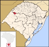
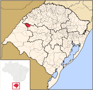
Itacurubi
Encyclopedia
| Map | |
|---|---|
 |
|
| Statistics | |
| State: | Rio Grande do Sul Rio Grande do Sul Rio Grande do Sul is the southernmost state in Brazil, and the state with the fifth highest Human Development Index in the country. In this state is located the southernmost city in the country, Chuí, on the border with Uruguay. In the region of Bento Gonçalves and Caxias do Sul, the largest wine... |
| Meso-region: | Westcentral Rio Grande do Sul (Centro Ocidental Rio-Grandense) Centro Ocidental Rio-Grandense The Centro Ocidental Rio-Grandense is one of the seven meso-regions of the state of Rio Grande do Sul in Brazil. It consists of the union of 31 municipalities, grouped in three microregions.-Microrregions:* Restinga Seca* Santa Maria* Santiago... |
| Micro-Region: | Santiago Santiago (micro-region) The Santiago micro-region is a micro-region in the western part of the state of Rio Grande do Sul, Brazil. The area is 10,750.721 km².- Municipalities:* Capão do Cipó* Itacurubi* Jari* Júlio de Castilhos* Pinhal Grande... |
| Founded: | September 5, 1988 |
| Location Location (geography) The terms location and place in geography are used to identify a point or an area on the Earth's surface or elsewhere. The term 'location' generally implies a higher degree of can certainty than "place" which often has an ambiguous boundary relying more on human/social attributes of place identity... : |
28.795/28° 47' 42" S lat. 55.235/55° 14' 7" W long. |
| Area Area Area is a quantity that expresses the extent of a two-dimensional surface or shape in the plane. Area can be understood as the amount of material with a given thickness that would be necessary to fashion a model of the shape, or the amount of paint necessary to cover the surface with a single coat... : |
1,120.8 km² |
| Population Population A population is all the organisms that both belong to the same group or species and live in the same geographical area. The area that is used to define a sexual population is such that inter-breeding is possible between any pair within the area and more probable than cross-breeding with individuals... (2003): - Total - Change - Density |
3,571 - 3.2/km² |
| Elevation Elevation The elevation of a geographic location is its height above a fixed reference point, most commonly a reference geoid, a mathematical model of the Earth's sea level as an equipotential gravitational surface .... : |
160 m |
| Postal code: | 97685-xxx |
| Website: | www.itacurubi.rs.gov.br |
| Politics | |
| Mayor Mayor In many countries, a Mayor is the highest ranking officer in the municipal government of a town or a large urban city.... : |
|
Itacurubi is a municipality
Municipality
A municipality is essentially an urban administrative division having corporate status and usually powers of self-government. It can also be used to mean the governing body of a municipality. A municipality is a general-purpose administrative subdivision, as opposed to a special-purpose district...
of the western part of the state of Rio Grande do Sul
Rio Grande do Sul
Rio Grande do Sul is the southernmost state in Brazil, and the state with the fifth highest Human Development Index in the country. In this state is located the southernmost city in the country, Chuí, on the border with Uruguay. In the region of Bento Gonçalves and Caxias do Sul, the largest wine...
, Brazil
Brazil
Brazil , officially the Federative Republic of Brazil , is the largest country in South America. It is the world's fifth largest country, both by geographical area and by population with over 192 million people...
. Its area is 1,120.8 km² and its population was 3,571 in 2003. Its elevation is at 169 m. The origin of the name comes from the Tupi language. It is located 627 km west of the state capital of Porto Alegre
Porto Alegre
Porto Alegre is the tenth most populous municipality in Brazil, with 1,409,939 inhabitants, and the centre of Brazil's fourth largest metropolitan area . It is also the capital city of the southernmost Brazilian state of Rio Grande do Sul. The city is the southernmost capital city of a Brazilian...
, northeast of Alegrete
Alegrete
Alegrete is a town and a municipality in Rio Grande do Sul located in southern Brazil. Its medium altitude is 102 m. Its estimated population in 2008 was 78,984 inhabitants and the total area is 7,803.967 km² . Its inhabitants are called Alegretenses.Alegrete was settled in 1816 and became a...
.
External links
- http://www.citybrazil.com.br/rs/itacurubi/
- Map and Aerial photos:
- Coordinates: 28°47′43"S 55°14′7"W
- Street maps: Street map from Mapquest, MapPoint or Google
- Satellite images and Aerial photos: Google