

Ipswich Road, Brisbane
Encyclopedia
Ipswich Road is one Brisbane
's main roads connecting Brisbane to the nearby city of Ipswich
, via the Ipswich Motorway
. Logan Road, Pacific Motorway
, and Beaudesert Road (Mount Lindesay Highway
) are the other major roads in the south of Brisbane. The road was an important transport route in 19th century Brisbane. Travelling south the road begins at the Woolloongabba Five Ways intersection with Stanley Street and Logan Road
, connecting the inner southern suburbs with southwest Brisbane.
The heritage listed Norman Hotel is positioned on Ipswich Road at Woolloongabba
. The establishment was built in 1889, opened in 1890 and quickly became a local landmark.
The North-South Bypass Tunnel
has an entry and exit point on Ipswich Road at Woolloongabba, the same place that the South East Freeway crosses over the road. Also in this vicinity the Eastern Busway
crosses Ipswhich Road. At Buranda
is the Princess Alexandra Hospital
and in Yeronga
the road lies adjacent to Yeronga Park
.
 At Moorooka
the major arterial road called Beaudesert Road branches to the south east through the industrial suburbs of Salisbury
, Acacia Ridge
continuing on to the northern outskirts of Logan City. It is when Beaudesert Road crosses the Logan Motorway
that Beaudesert Road becomes the Mount Lindesay Highway
, which continues through to Logan, Jimboomba, Beaudesert
and Mount Lindesay and beyond to the Queensland-New South Wales border.
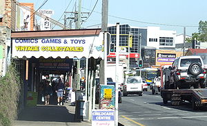
South from this intersection the road is lined with numerous car sale yards and is known as the Moorooka Magic Mile of Motors. At Rocklea
the road becomes the upgraded Ipswich Motorway after crossing over the Beenleigh railway line.
At morning peak times the road can be congested anywhere from Annerley
towards the city. According to the Brisbane City Council compared to 2007 rates, by 2016 the road is expected to carry an extra 12,000 cars each day.
The last tram service in Brisbane
took route S34 along Ipswich Road into Tottenham Road and the Ipswich Road Depot on 14 April 1969.
Brisbane
Brisbane is the capital and most populous city in the Australian state of Queensland and the third most populous city in Australia. Brisbane's metropolitan area has a population of over 2 million, and the South East Queensland urban conurbation, centred around Brisbane, encompasses a population of...
's main roads connecting Brisbane to the nearby city of Ipswich
Ipswich, Queensland
Ipswich is a city in South-East Queensland, Australia. Situated along the Bremer River Valley approximately 40 kilometres away from the state's capital Brisbane. The suburb by the same name forms the city's Central Business District and administrative centre...
, via the Ipswich Motorway
Ipswich Motorway
The M7 runs from the junction of Ipswich Road and Granard Road to the M2 Logan Motorway interchange. It is then signed M2 until the junction of the Warrego Highway and the Cunningham Highway between Brisbane and Ipswich in South East Queensland, Australia.It initially passes through the suburbs of...
. Logan Road, Pacific Motorway
Pacific Motorway
The Pacific Motorway is a 100 km long motorway in Australia between Brisbane, Queensland, and the New South Wales-Queensland border at Tweed Heads. The motorway starts at Coronation Drive at Milton in Brisbane, and from 2008 links the Tweed Heads bypass in New South Wales...
, and Beaudesert Road (Mount Lindesay Highway
Mount Lindesay Highway
The Mount Lindesay Highway is a highway in Queensland which has been given the national route number 13. It runs from Brisbane, where it leaves Ipswich Road in the suburb of Moorooka , to the New South Wales border where it becomes the Summerland Way heading south to Kyogle.The highway used to...
) are the other major roads in the south of Brisbane. The road was an important transport route in 19th century Brisbane. Travelling south the road begins at the Woolloongabba Five Ways intersection with Stanley Street and Logan Road
Logan Road, Brisbane
Logan Road is a major road in Brisbane, Queensland. It runs 16 km from Springwood to Woolloongabba, with most of the route signed as state route 95...
, connecting the inner southern suburbs with southwest Brisbane.
The heritage listed Norman Hotel is positioned on Ipswich Road at Woolloongabba
Woolloongabba, Queensland
Woolloongabba is an inner suburb of Brisbane, Australia located 4 km south of the Brisbane CBD.Experts are divided regarding the Aboriginal meaning of the name, preferring either 'whirling waters' or 'fight talk place'...
. The establishment was built in 1889, opened in 1890 and quickly became a local landmark.
The North-South Bypass Tunnel
North-South Bypass Tunnel, Brisbane
The M7 Clem Jones Tunnel , known during its development as the North-South Bypass Tunnel , is a A$3.2 billion toll road built under the Brisbane River, which crosses between the suburbs of Woolloongabba and Bowen Hills in Brisbane, Australia. The CLEM7 Community Open Day, a public open day...
has an entry and exit point on Ipswich Road at Woolloongabba, the same place that the South East Freeway crosses over the road. Also in this vicinity the Eastern Busway
Eastern Busway
The Eastern Busway is a bus-only corridor in Brisbane, Queensland. The busway runs from the University of Queensland St Lucia Campus via the Eleanor Schonell Bridge, connects with the South East Busway at Buranda busway station and then extends to Coorparoo following the Old Cleveland Road...
crosses Ipswhich Road. At Buranda
Buranda, Queensland
Buranda is a locality in the southern Brisbane suburbs of Greenslopes and Annerley, in Brisbane, Australia.The location is an important transport hub for southern Brisbane. Logan Road and Ipswich Road pass through the area as does the South East Busway with a station called Buranda busway station. ...
is the Princess Alexandra Hospital
Princess Alexandra Hospital
The Princess Alexandra Hospital , is located on Ipswich Road in Woolloongabba, Australia. It is one of the major hospitals in Brisbane and is a teaching hospital of the University of Queensland. It is a tertiary level teaching hospital with all major medical and surgical specialities onsite except...
and in Yeronga
Yeronga, Queensland
Yeronga is a suburb of Brisbane, Australia located on the Brisbane River 7 km south of the Brisbane CBD. Yeronga is a residential suburb. It is home to the Yeronga Devils.-Transport:There is a Yeronga train station on the Beenleigh railway line....
the road lies adjacent to Yeronga Park
Yeronga Park
Yeronga Memorial Park was one of Brisbane's second earliest parks, originally reserved in 1888. The sprawling park caters for sports and recreational activities and is a significant World War I and World War II place of remembrance...
.
Moorooka, Queensland
Moorooka is a suburb of Brisbane, the state capital of Queensland, Australia. Bordering with Toohey Forest Park, it is seven kilometres south of Brisbane's central business district...
the major arterial road called Beaudesert Road branches to the south east through the industrial suburbs of Salisbury
Salisbury, Queensland
Salisbury is a suburb of Brisbane, Australia. It is south of the Brisbane central business district.Salisbury was named after the residence of William Coote, an early Brisbane journalist and political figure, who lived in the area....
, Acacia Ridge
Acacia Ridge, Queensland
Acacia Ridge is a suburb of Brisbane, Queensland, Australia. Acacia Ridge is south of the central business district. The population in the 2001 census was 6648....
continuing on to the northern outskirts of Logan City. It is when Beaudesert Road crosses the Logan Motorway
Logan Motorway
The M2/MR6 Logan Motorway offers motorists a quick link between Ipswich and the M1 or Pacific Motorway at Loganholme, and the Gateway Motorway, providing access to the Gold Coast on the eastern seaboard and to the rural areas of the Darling Downs to the west....
that Beaudesert Road becomes the Mount Lindesay Highway
Mount Lindesay Highway
The Mount Lindesay Highway is a highway in Queensland which has been given the national route number 13. It runs from Brisbane, where it leaves Ipswich Road in the suburb of Moorooka , to the New South Wales border where it becomes the Summerland Way heading south to Kyogle.The highway used to...
, which continues through to Logan, Jimboomba, Beaudesert
Beaudesert
Beaudesert could refer to:*Beaudesert, Queensland, a town in Australia*Electoral district of Beaudesert, an Australian electroral district, which includes the town of Beaudesert, Queensland*Beaudesert, Warwickshire, a village in Warwickshire, England...
and Mount Lindesay and beyond to the Queensland-New South Wales border.
South from this intersection the road is lined with numerous car sale yards and is known as the Moorooka Magic Mile of Motors. At Rocklea
Rocklea, Queensland
The large Brisbane suburb of Rocklea is located 12 kilometres south of the city. At times the suburb has experienced significant flooding from the nearby Brisbane River. The west of the suburb is bordered by the Oxley Creek....
the road becomes the upgraded Ipswich Motorway after crossing over the Beenleigh railway line.
At morning peak times the road can be congested anywhere from Annerley
Annerley, Queensland
Annerley is a suburb of Brisbane, Australia located 6 km south of the Brisbane CBD. It was named after a town in England.-Geography:Much of the suburb is elevated, lying on a ridge that gives views of the city...
towards the city. According to the Brisbane City Council compared to 2007 rates, by 2016 the road is expected to carry an extra 12,000 cars each day.
The last tram service in Brisbane
Trams in Brisbane
The Brisbane tramway network once served Brisbane, the capital city of Queensland, Australia. It operated between 1885 and 1969 and ran on standard gauge track. The electric system was originally energised to 500 volts, and subsequently increased to 600 volts. All tramcars built in Brisbane up to...
took route S34 along Ipswich Road into Tottenham Road and the Ipswich Road Depot on 14 April 1969.