
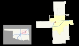
Interstate 444
Encyclopedia
Interstate 444 is an unsigned auxiliary route of the Interstate Highway System
, with both ends at Interstate 244 in downtown Tulsa, Oklahoma
. It makes up the eastern and southern sections on the square-shaped Inner Dispersal Loop.
It is one of a few unsigned Interstates. It is instead signed as U.S. Highway 75, with the first half of the highway also being signed as U.S. Highway 64 and State Highway 51
. The I-444 designation does appear on Rand McNally
Maps, and can also appear on some online driving direction maps, like MSN Maps.
signs simply bore the letter suffixes "A", "B", and "C") the 94D marking remained. The number became even more out of place when the other signs were replaced, bearing no exit numbers.
, Tulsa
.
Interstate Highway System
The Dwight D. Eisenhower National System of Interstate and Defense Highways, , is a network of limited-access roads including freeways, highways, and expressways forming part of the National Highway System of the United States of America...
, with both ends at Interstate 244 in downtown Tulsa, Oklahoma
Tulsa, Oklahoma
Tulsa is the second-largest city in the state of Oklahoma and 46th-largest city in the United States. With a population of 391,906 as of the 2010 census, it is the principal municipality of the Tulsa Metropolitan Area, a region with 937,478 residents in the MSA and 988,454 in the CSA. Tulsa's...
. It makes up the eastern and southern sections on the square-shaped Inner Dispersal Loop.
It is one of a few unsigned Interstates. It is instead signed as U.S. Highway 75, with the first half of the highway also being signed as U.S. Highway 64 and State Highway 51
State Highway 51 (Oklahoma)
State Highway 51, abbreviated to SH-51 or OK-51, is a major state highway in Oklahoma. It runs for 333 miles east–west across the state, running from the Texas state line to Arkansas. It is the third-longest state highway in the system.-Texas to I-35:SH-51 begins at the Texas line concurrent...
. The I-444 designation does appear on Rand McNally
Rand McNally
Rand McNally is an American publisher of maps, atlases, textbooks, and globes for travel, reference, commercial, and educational uses. It also provides online consumer street maps and directions, as well as commercial transportation routing software and mileage data...
Maps, and can also appear on some online driving direction maps, like MSN Maps.
History
At the time I-44 was designated, the mile markers in the Tulsa area were in the 90s range. Rather than having their own numbers, I-244 and I-444 started their numbering based on what mile marker the highways were at when they branched off. Therefore, one exit along I-444 was labeled "94D". When the I-444 signs were removed from the highway and the "94" numbers were removed from the other markers (their goreGore (road)
A gore, gore point, or gore zone is a triangular piece of land found where roads merge or split. When two roads merge, the area is sometimes referred to as a merge nose...
signs simply bore the letter suffixes "A", "B", and "C") the 94D marking remained. The number became even more out of place when the other signs were replaced, bearing no exit numbers.
Exit list
Exit numbers no longer exist. (See History section above for explanation of exit numbers.) The whole route is in Tulsa CountyTulsa County, Oklahoma
Tulsa County is a county located in the U.S. state of Oklahoma. According to the 2010 U.S. Census, the population is 603,403. Its county seat is Tulsa.-History of Tulsa County:The history of Tulsa County greatly overlaps the history of the city of Tulsa...
, Tulsa
Tulsa, Oklahoma
Tulsa is the second-largest city in the state of Oklahoma and 46th-largest city in the United States. With a population of 391,906 as of the 2010 census, it is the principal municipality of the Tulsa Metropolitan Area, a region with 937,478 residents in the MSA and 988,454 in the CSA. Tulsa's...
.
| Mile | # Exit number An exit number is a number assigned to a road junction, usually an exit from a freeway. It is usually marked on the same sign as the destinations of the exit, as well as a sign in the gore.... |
Destinations | Notes |
|---|---|---|---|
| 94A | westbound exit and eastbound entrance; US-75 joins eastbound and leaves westbound | ||
| 94B | westbound exit and eastbound entrance; US-64 and SH-51 join eastbound and leave westbound | ||
| 94C | 11th Street, Houston Avenue | westbound exit and eastbound entrance | |
| 94D | 13th Street, Denver Avenue, Cheyenne Avenue | ||
| US-64 and SH-51 join westbound and leave eastbound | |||
| 96A | 7th Street — Downtown | ||
| 96B | eastbound exit and westbound entrance | ||
| 96C | eastbound exit and westbound entrance |