
Indiana State Road 60
Encyclopedia
State Road 60 in the U.S. State
of Indiana
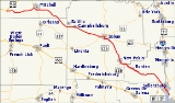
is a mostly rural, two-lane highway in the southeastern portion of the state, covering a distance of about 62 miles (99.8 km).
 SR 60 begins at U.S. Route 50
east of Huron in southern Lawrence County
and runs east towards Mitchell
. In Mitchell, SR 56 is concurrency
with State Road 37
. After Mitchell SR 60 heads southeast toward Salem
, passing through Campbellsburg
. In Salem SR 60 are concurrenct with State Road 56
and State Road 135
. Southeast from downtown Salem SR 60 has an intersection
with Indiana State Road 160
. SR 60 leaves Salem heading south-southeast towards Sellersburg
, passing through New Pekin
and Bennettsville
. In Sellersburg SR 60 passes over Interstate 65
(I-65), followed by an intersection at U.S. Route 31.
.
U.S. state
A U.S. state is any one of the 50 federated states of the United States of America that share sovereignty with the federal government. Because of this shared sovereignty, an American is a citizen both of the federal entity and of his or her state of domicile. Four states use the official title of...
of Indiana
Indiana
Indiana is a US state, admitted to the United States as the 19th on December 11, 1816. It is located in the Midwestern United States and Great Lakes Region. With 6,483,802 residents, the state is ranked 15th in population and 16th in population density. Indiana is ranked 38th in land area and is...
is a mostly rural, two-lane highway in the southeastern portion of the state, covering a distance of about 62 miles (99.8 km).
Route description
U.S. Route 50 in Indiana
In the U.S. state of Indiana, U.S. Route 50 is a major east–west route. It enters Indiana from Illinois and leaves Indiana into Ohio.- Route description :...
east of Huron in southern Lawrence County
Lawrence County, Indiana
As of the census of 2000, there were 45,922 people, 18,535 households, and 13,141 families residing in the county. The population density was 102 people per square mile . There were 20,560 housing units at an average density of 46 per square mile...
and runs east towards Mitchell
Mitchell, Indiana
Mitchell is a city in Lawrence County, Indiana, United States. The population was 4,567 as of the 2000 census.It is the birthplace of astronaut Gus Grissom, who flew on Liberty Bell 7, Gemini 3, and died in a launch pad fire at Kennedy Space Center in 1967....
. In Mitchell, SR 56 is concurrency
Concurrency (road)
A concurrency, overlap, or coincidence in a road network is an instance of one physical road bearing two or more different highway, motorway, or other route numbers...
with State Road 37
Indiana State Road 37
State Road 37 in the U.S. State of Indiana is a major route in Indiana, running as a 4-lane divided highway for 110 miles of its course....
. After Mitchell SR 60 heads southeast toward Salem
Salem, Indiana
Salem is a city in Washington Township, Washington County, Indiana, United States. Salem serves as the county seat, and its downtown area is on the National Register of Historic Places...
, passing through Campbellsburg
Campbellsburg, Indiana
Campbellsburg is a town in Brown Township, Washington County, Indiana, United States. The population was 578 at the 2000 census. It was named for Robert Campbell, who laid out the streets in 1851.-Geography:...
. In Salem SR 60 are concurrenct with State Road 56
Indiana State Road 56
State Road 56 in the U.S. state of Indiana is a route that travels the south central part of the state from west to east.-Route description:...
and State Road 135
Indiana State Road 135
State Road 135 in the U.S. State of Indiana is a road that connects Indianapolis with the Ohio River; for the most part it is a two-lane road.-Route description:The southern terminus is the Matthew E. Welsh Bridge on the east side of Mauckport...
. Southeast from downtown Salem SR 60 has an intersection
Intersection (road)
An intersection is a road junction where two or more roads either meet or cross at grade . An intersection may be 3-way - a T junction or fork, 4-way - a crossroads, or 5-way or more...
with Indiana State Road 160
Indiana State Road 160
State Road 160 in the U.S. State of Indiana is a narrow two-lane road that crosses the scenic hill country of Washington, Scott and Clark counties.-Route description:The western terminus of State Road 160 is in Salem at its parent route, State Road 60...
. SR 60 leaves Salem heading south-southeast towards Sellersburg
Sellersburg, Indiana
Sellersburg is a city located within Silver Creek Township, Clark County, Indiana, United States. It had a population of 6,128 at time of the 2010 census...
, passing through New Pekin
New Pekin, Indiana
New Pekin is a town in Pierce and Polk townships, Washington County, Indiana, United States. The population was 1,401 at the 2010 census.-Geography:New Pekin is located at ....
and Bennettsville
Bennettsville, Indiana
Bennettsville is an unincorporated town in Carr Township, Clark County, Indiana....
. In Sellersburg SR 60 passes over Interstate 65
Interstate 65 in Indiana
In the U.S. state of Indiana, Interstate 65 traverses the state from south to north. The Indiana portion begins near Louisville, Kentucky and travels north, passing through Columbus, Indianapolis, Lafayette. Interstate 65 terminates near Gary on the Indiana Toll Road. Interstate 65 covers 261.27...
(I-65), followed by an intersection at U.S. Route 31.
History
Western section of SR 60 from US 50 to SR 37 was number State Road 250Indiana State Road 250
State Road 250 in the U.S. State of Indiana is a secondary route that runs from U.S. Route 50 in Brownstown eastward toward the Ohio River at State Road 156 in Patriot in southeast Indiana. Towns include Uniontown, Paris Crossing, Canaan, and East Enterprise...
.