
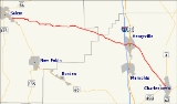
Indiana State Road 160
Encyclopedia
State Road 160 in the U.S. State
of Indiana
is a narrow two-lane road that crosses the scenic hill country of Washington
, Scott
and Clark
counties.
at its parent route, State Road 60
. It passes to the south of the Clark State Forest
just before reaching Henryville
, where it intersects with Interstate 65
(Exit 19) and U.S. Route 31
. Its eastern terminus is in Charlestown
at State Road 403
.
.
U.S. state
A U.S. state is any one of the 50 federated states of the United States of America that share sovereignty with the federal government. Because of this shared sovereignty, an American is a citizen both of the federal entity and of his or her state of domicile. Four states use the official title of...
of Indiana
Indiana
Indiana is a US state, admitted to the United States as the 19th on December 11, 1816. It is located in the Midwestern United States and Great Lakes Region. With 6,483,802 residents, the state is ranked 15th in population and 16th in population density. Indiana is ranked 38th in land area and is...
is a narrow two-lane road that crosses the scenic hill country of Washington
Washington County, Indiana
Washington County is a county located in the U.S. state of Indiana. As of 2010, the population was 28,262. The county seat is Salem.Washington County is part of the Louisville/Jefferson County, KY–IN Metropolitan Statistical Area.-Early settlers:...
, Scott
Scott County, Indiana
As of the census of 2000, there were 22,960 people, 8,832 households, and 6,491 families residing in the county. The population density was 121 people per square mile . There were 9,737 housing units at an average density of 51 per square mile...
and Clark
Clark County, Indiana
Clark County is a county located in the U.S. state of Indiana, located directly across the Ohio River from Louisville, Kentucky. At the 2010 Census, the population was 110,232. The county seat is Jeffersonville. Clarksville is also a major city in the county...
counties.
Route description
The western terminus of State Road 160 is in SalemSalem, Indiana
Salem is a city in Washington Township, Washington County, Indiana, United States. Salem serves as the county seat, and its downtown area is on the National Register of Historic Places...
at its parent route, State Road 60
Indiana State Road 60
State Road 60 in the U.S. State of Indiana is a mostly rural, two-lane highway in the southeastern portion of the state, covering a distance of about .-Route description:...
. It passes to the south of the Clark State Forest
Clark State Forest
Clark State Forest, located just north of Henryville, Indiana in the United States, is Indiana's oldest state forest, formed in 1903 as a forest research facility and a nursery and later expanded by the Works Progress Administration. Originally 2,028 acres of total land area, it is now almost...
just before reaching Henryville
Henryville, Indiana
Henryville is a census-designated place in Clark County, Indiana, United States. The population was 1,905 at the 2010 census.-Geography:Henryville is located at ....
, where it intersects with Interstate 65
Interstate 65
Interstate 65 is a major Interstate Highway in the United States. The southern terminus is located at an intersection with Interstate 10 in Mobile, Alabama, and its northern terminus is at an interchange with Interstate 90 , U.S. Route 12, and U.S...
(Exit 19) and U.S. Route 31
U.S. Route 31
U.S. Route 31 is a long north–south highway connecting northern Michigan to southern Alabama, with its northern terminus at Interstate 75 near Mackinaw City, Michigan, and southern terminus at the combined U.S. Route 90 & U.S. Route 98 at Spanish Fort, Alabama...
. Its eastern terminus is in Charlestown
Charlestown, Indiana
-Demographics:As of the census of 2000, there were 5,993 people, 2,341 households, and 1,615 families residing in the city. The population density was 2,570.0 people per square mile . There were 2,489 housing units at an average density of 1,067.4 per square mile...
at State Road 403
Indiana State Road 403
State Road 403 is a six-mile northeast-to-southwest route that lies entirely within Clark County.-Route description:State Road 403 begins in the north end of Sellersburg at U.S. Route 31, just south of the community of Speed. The road runs northeast in a straight line toward central Charlestown...
.
History
SR 160 from Charlestown to Henryville was number State Road 39Indiana State Road 39
State Road 39 in the U.S. State of Indiana is the name of two distinct north–south highways in the state of Indiana.-Southern section:Located in south-central Indiana, the shorter southern section of State Road 39 begins at State Road 56 west of Scottsburg. It runs north and passes through...
.