
Indiana State Road 135
Encyclopedia
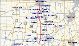
State Road 135 in the U.S. State
of Indiana
is a road that connects Indianapolis
with the Ohio River
; for the most part it is a two-lane road.
on the east side of Mauckport
. The bridge connects to Kentucky Route 79
in Brandenburg, Kentucky
on the south side of the river.
The road runs north along rolling terrain in Harrison and Washington counties. It continues north through hilly country, passing Starve Hollow Lake State Recreation Area
in Jackson County and the Brown County State Park. It then passes into the flatter terrain of Johnson
and Marion
counties.
The northern terminus is at U.S. Route 31
on the south side of Indianapolis, about 0.5 mile (0.80467 km) south of its interchange with Interstate 465
. State Road 135 previously terminated a few miles farther north in the city, but was shifted down to its current northernmost location of Thompson Road when U.S. Highways and Indiana State Roads were all rerouted around major cities onto available bypasses in the early 1990s.
was commissioned in Indiana.
U.S. state
A U.S. state is any one of the 50 federated states of the United States of America that share sovereignty with the federal government. Because of this shared sovereignty, an American is a citizen both of the federal entity and of his or her state of domicile. Four states use the official title of...
of Indiana
Indiana
Indiana is a US state, admitted to the United States as the 19th on December 11, 1816. It is located in the Midwestern United States and Great Lakes Region. With 6,483,802 residents, the state is ranked 15th in population and 16th in population density. Indiana is ranked 38th in land area and is...
is a road that connects Indianapolis
Indianapolis, Indiana
Indianapolis is the capital of the U.S. state of Indiana, and the county seat of Marion County, Indiana. As of the 2010 United States Census, the city's population is 839,489. It is by far Indiana's largest city and, as of the 2010 U.S...
with the Ohio River
Ohio River
The Ohio River is the largest tributary, by volume, of the Mississippi River. At the confluence, the Ohio is even bigger than the Mississippi and, thus, is hydrologically the main stream of the whole river system, including the Allegheny River further upstream...
; for the most part it is a two-lane road.
Route description
The southern terminus is the Matthew E. Welsh BridgeMatthew E. Welsh Bridge
Matthew E. Welsh Bridge is a two-lane, single-deck continuous truss bridge on the Ohio River. The bridge connects Kentucky Route 79 and Indiana State Road 135, as well as the communities of Brandenburg, Kentucky and Mauckport, Indiana....
on the east side of Mauckport
Mauckport, Indiana
Mauckport is a town in Heth Township, Harrison County, Indiana, along the Ohio River. The population was 81 at the 2010 census.-History:In the earliest times Daniel Boone and his brothers, most notably Squire Boone, were regularly in the area of Mauckport. Squire Boone settled in the area in 1806...
. The bridge connects to Kentucky Route 79
Kentucky Route 79
Kentucky Route 79 originates at a junction with US 431 in downtown Russellville in Logan County. The route continues through Morgantown, Caneyville, Short Creek, Cannons Point, Harned, and Irvington, to terminate at the Ohio River near Brandenburg in Meade County, where, after crossing the Matthew E...
in Brandenburg, Kentucky
Brandenburg, Kentucky
Brandenburg is a city in Meade County, Kentucky, United States, along the Ohio River. The population was 2,049 at the 2000 census. It is the county seat of Meade County.-History:...
on the south side of the river.
The road runs north along rolling terrain in Harrison and Washington counties. It continues north through hilly country, passing Starve Hollow Lake State Recreation Area
Starve Hollow Lake State Recreation Area
Starve Hollow Lake State Recreation Area is a outdoor recreation area and wildlife habitat in Jackson County, Indiana. The lake covers , and is surrounded by the nearly Jackson-Washington State Forest. The lake is very shallow as a result of sediment...
in Jackson County and the Brown County State Park. It then passes into the flatter terrain of Johnson
Johnson County, Indiana
As of the census of 2000, there were 115,209 people, 42,434 households, and 31,613 families residing in the county. The population density was 360 people per square mile . There were 45,095 housing units at an average density of 141 per square mile...
and Marion
Marion County, Indiana
Marion County is a county located in the U.S. state of Indiana. Census 2010 recorded a population of 903,393, making it the largest county in the state and 55th most populated county in the country, greater than the population of six states. The county seat is Indianapolis, the state capital and...
counties.
The northern terminus is at U.S. Route 31
U.S. Route 31
U.S. Route 31 is a long north–south highway connecting northern Michigan to southern Alabama, with its northern terminus at Interstate 75 near Mackinaw City, Michigan, and southern terminus at the combined U.S. Route 90 & U.S. Route 98 at Spanish Fort, Alabama...
on the south side of Indianapolis, about 0.5 mile (0.80467 km) south of its interchange with Interstate 465
Interstate 465
Interstate 465 , also known as the USS Indianapolis Memorial Highway, is the beltway circling Indianapolis, Indiana, United States. It is roughly rectangular in shape and has a perimeter of approximately 53 miles . It lies almost completely within the boundaries of Marion County, except for two...
. State Road 135 previously terminated a few miles farther north in the city, but was shifted down to its current northernmost location of Thompson Road when U.S. Highways and Indiana State Roads were all rerouted around major cities onto available bypasses in the early 1990s.
History
State Road 135 was known as State Road 35 until U.S. Route 35U.S. Route 35
U.S. Route 35 is a north–south United States highway that runs northwest-southeast for approximately from northern Indiana to the western suburbs of Charleston, West Virginia. The highway's northern terminus is in Michigan City, Indiana, at U.S. Route 20. Its southern terminus is in Scott...
was commissioned in Indiana.