
Indiana State Road 144
Encyclopedia
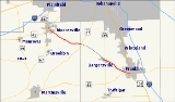
State Road 144 in the U.S. State
of Indiana
is a highway that exists in two short sections south of Indianapolis
.
and the eastern terminus of Indiana State Road 42
in Mooresville
southeast to its parent route, Indiana State Road 44
, in Franklin
.
near the Morgan
/Johnson County
line in the west to Indiana State Road 135
in Old Bargersville, Indiana
, in the east, was downgraded to county road status in early 2005. It is one of the very few county roads in Indiana with a numerical designation identical to that of an adjoining state road, similar to how it is done in Florida.
|colspan=5 align=center |Gap in route
U.S. state
A U.S. state is any one of the 50 federated states of the United States of America that share sovereignty with the federal government. Because of this shared sovereignty, an American is a citizen both of the federal entity and of his or her state of domicile. Four states use the official title of...
of Indiana
Indiana
Indiana is a US state, admitted to the United States as the 19th on December 11, 1816. It is located in the Midwestern United States and Great Lakes Region. With 6,483,802 residents, the state is ranked 15th in population and 16th in population density. Indiana is ranked 38th in land area and is...
is a highway that exists in two short sections south of Indianapolis
Indianapolis, Indiana
Indianapolis is the capital of the U.S. state of Indiana, and the county seat of Marion County, Indiana. As of the 2010 United States Census, the city's population is 839,489. It is by far Indiana's largest city and, as of the 2010 U.S...
.
Route description
State Road 144 runs from its northwest end at the southern terminus of Indiana State Road 267Indiana State Road 267
State Road 267 in the U.S. state of Indiana is a north–south route connecting Interstate 65 in Boone County with State Road 42 in Mooresville. It passes through the towns of Brownsburg, Avon, Plainfield, and Mooresville in the counties of Boone, Hendricks, and Morgan.- Route description...
and the eastern terminus of Indiana State Road 42
Indiana State Road 42
State Road 42 is an east–west road in Central Indiana. Its western terminus is at State Road 46 in Terre Haute. Its eastern terminus is at State Road 67 and State Road 144 in Mooresville.- Route description :...
in Mooresville
Mooresville, Indiana
Mooresville is a town in Brown Township, Morgan County, Indiana, in the United States. As of the 2010 census, the town population was 9,326. It was founded in 1824 by Samuel Moore, a Quaker from North Carolina.-Geography:Mooresville is located at ....
southeast to its parent route, Indiana State Road 44
Indiana State Road 44
State Road 44 in the U.S. State of Indiana begins in the west at State Road 37 in Martinsville and runs eastward to the Ohio state line in Union County. It passes through the following towns:- Route description :...
, in Franklin
Franklin, Indiana
As of the census of 2000, there were 19,463 people, 6,824 households, and 4,872 families residing in the city. The population increased by more than 50% during the 1990s , with new residents attracted by jobs in the community, as well as some people commuting to Indianapolis for work. The...
.
History
The middle one-third of its run, from Indiana State Road 37Indiana State Road 37
State Road 37 in the U.S. State of Indiana is a major route in Indiana, running as a 4-lane divided highway for 110 miles of its course....
near the Morgan
Morgan County, Indiana
Morgan County is a county located in the U.S. state of Indiana. As of 2010, the population was 68,894. The county seat is Martinsville. Morgan is one of seven counties contiguous to Marion County, and is located between Indianapolis, in Marion County, and Bloomington, located in Monroe County...
/Johnson County
Johnson County, Indiana
As of the census of 2000, there were 115,209 people, 42,434 households, and 31,613 families residing in the county. The population density was 360 people per square mile . There were 45,095 housing units at an average density of 141 per square mile...
line in the west to Indiana State Road 135
Indiana State Road 135
State Road 135 in the U.S. State of Indiana is a road that connects Indianapolis with the Ohio River; for the most part it is a two-lane road.-Route description:The southern terminus is the Matthew E. Welsh Bridge on the east side of Mauckport...
in Old Bargersville, Indiana
Old Bargersville, Indiana
Old Bargersville is an unincorporated town in Union Township, Johnson County, Indiana....
, in the east, was downgraded to county road status in early 2005. It is one of the very few county roads in Indiana with a numerical designation identical to that of an adjoining state road, similar to how it is done in Florida.
Major intersections
|-|colspan=5 align=center |Gap in route