
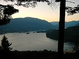
Indian Arm
Encyclopedia

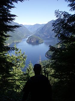
Fjord
Geologically, a fjord is a long, narrow inlet with steep sides or cliffs, created in a valley carved by glacial activity.-Formation:A fjord is formed when a glacier cuts a U-shaped valley by abrasion of the surrounding bedrock. Glacial melting is accompanied by rebound of Earth's crust as the ice...
adjacent to the city of Vancouver
Vancouver
Vancouver is a coastal seaport city on the mainland of British Columbia, Canada. It is the hub of Greater Vancouver, which, with over 2.3 million residents, is the third most populous metropolitan area in the country,...
in southwestern British Columbia
British Columbia
British Columbia is the westernmost of Canada's provinces and is known for its natural beauty, as reflected in its Latin motto, Splendor sine occasu . Its name was chosen by Queen Victoria in 1858...
. Formed during the last Ice Age
Ice age
An ice age or, more precisely, glacial age, is a generic geological period of long-term reduction in the temperature of the Earth's surface and atmosphere, resulting in the presence or expansion of continental ice sheets, polar ice sheets and alpine glaciers...
, it extends due north from Burrard Inlet
Burrard Inlet
Burrard Inlet is a relatively shallow-sided coastal fjord in southwestern British Columbia, Canada. Formed during the last Ice Age, it separates the City of Vancouver and the rest of the low-lying Burrard Peninsula from the slopes of the North Shore Mountains, home to the communities of West...
, between the communities of Belcarra (to the east) and the District of North Vancouver
North Vancouver, British Columbia (district municipality)
The District of North Vancouver is a district municipality in British Columbia and is part of the GVRD. It surrounds the City of North Vancouver on three sides.-Geography:The District of North Vancouver is separated from Vancouver by Burrard Inlet...
(to the west), then on into mountainous wilderness. Burrard Inlet and the opening of Indian Arm was mapped by Captain George Vancouver
George Vancouver
Captain George Vancouver RN was an English officer of the British Royal Navy, best known for his 1791-95 expedition, which explored and charted North America's northwestern Pacific Coast regions, including the coasts of contemporary Alaska, British Columbia, Washington and Oregon...
and fully explored days later by Dionisio Alcalá Galiano
Dionisio Alcalá Galiano
Dionisio Alcalá Galiano was a Spanish naval officer, cartographer, and explorer. He mapped various coastlines in Europe and the Americas with unprecedented accuracy, using new technology such as chronometers...
in June 1792.
Geography

Squamish, British Columbia
Squamish is a community and a district municipality in the Canadian province of British Columbia, located at the north end of Howe Sound on the Sea to Sky Highway...
.
Scenery and attractions
The slopes along Indian Arm are either heavily forested or sheer granite cliffs. The inlet is narrow and the mountains rise steeply on both sides directly from the sea.There are several waterfalls, with the largest being Granite Falls at the north end on the east side. Spray of Pearls Falls at Wigwam Creek is in the north west corner, and Silver Falls is on the western side at Elsay Creek. There are also numerous unnamed seasonal waterfalls running over the rocky cliff walls that can best be viewed during spring run off. In winter, frozen ice-falls can be viewed.
Wildlife viewing can include seals, bald eagles, herons, and black bears. A large pink salmon run in odd-numbered years starts in July and continues to October; salmon and bear viewing opportunities concentrate at the Indian River estuary in the northwest corner of the inlet.
Recreation and Parks
Indian Arm Provincial ParkIndian Arm Provincial Park
Indian Arm Provincial Park is a provincial park in British Columbia, Canada. It is located on the western and eastern shores of Indian Arm, a glacial fjord extending north from Burrard Inlet near the city of Vancouver. The park also surrounds most of the land near Buntzen Lake, a reservoir managed...
includes large parts of both shores of the fjord, as well as Racoon and Twin Islands. This park is 6,826 hectares in total. There are wilderness campgrounds at sea level at Bishop Creek (west side), Granite Falls, and Twin Islands. The Park is popular with boaters and kayakers, and is also visited by charter boat day tours leaving from Granville Island, Port Moody, or Coal Harbour. Divers can visit the shallow water surrounding Racoon and Twin Islands.
A rough wilderness hiking trail around the perimeter of Indian Arm was completed in 2003. It was created over many years by engineer and trailbuilder Don McPherson; he also created the Grouse Grind hiking trail up the side of Grouse Mountain
Grouse Mountain
Grouse Mountain is one of the North Shore Mountains of the Pacific Ranges in North Vancouver, British Columbia, Canada. Exceeding 1,200 m in altitude at its peak, is the site of an alpine ski area in the winter season overlooking Greater Vancouver with four chairlifts facilitating 26 runs...
.
The south-eastern part of the Indian Arm park is adjacent to and partly surrounds the BC Hydro Buntzen Lake Recreation Area. Belcarra Park is managed by Metro Vancouver; this park surrounds Bedwell Bay on the mid-western side of Indian Arm, and includes the area around Sasamat Lake
Sasamat Lake
Sasamat Lake is located within Belcarra Regional Park. It is one of the warmest lakes in Greater Vancouver. At the south end of the lake there is a floating bridge, used for fishing or swimming. At the north end of the lake is White Pine Beach. Seasonal transit service is provide by Translink to...
. The Baden-Powell Trail
Baden-Powell Trail
The Baden-Powell Trail is a rugged but well-maintained trail that traverses Greater Vancouver's North Shore region. It was named after Lord Baden-Powell, founder of the world Scouting Movement.- Geography :...
is challenging but well-maintained and well-marked. It originates at Panorama Park in Deep Cove
Deep Cove, North Vancouver
Deep Cove refers to both the community in the easternmost part of the District of North Vancouver, in British Columbia, Canada, and also the geographic name of the small bay beside the town. It is affectionately referred to as "The Cove" by local residents. Located at the foot of Mount Seymour,...
, passing along the slopes of the mountains
North Shore Mountains
The North Shore Mountains are a mountain range overlooking Vancouver in British Columbia, Canada. Their southernmost peaks are visible from most areas in Vancouver and form a distinctive backdrop for the city....
on the western side of Indian Arm to its western terminus in Horseshoe Bay
Horseshoe Bay
There are various places named Horseshoe Bay:*Horseshoe Bay, West Vancouver, British Columbia, a neighbourhood and ferry terminal in West Vancouver, British Columbia, Canada*Horseshoe Bay, Queensland, Australia*Horseshoe Bay, New Zealand...
, West Vancouver.
Other parks around the shores of eastern Burrard Inlet and Indian Arm include: Cates Park and Panorama Park in the District of North Vancouver, Barnet Marine Park in Burnaby, Rocky Point Park
Rocky Point Park
Rocky Point Park, also known as Rocky Point, is situated along Burrard Inlet in Port Moody, British Columbia, next to the Port Moody Station Museum...
(which includes a boat launch), Inlet Park and Tidal Park in Port Moody, and Thwaytes Landing Metro Park Reserve.
First Nations Heritage
The Say Nuth Khaw Yum Heritage Park / Indian Arm Provincial Park was created in 1995 as part of the BC Government's Lower Mainland Nature Legacy Program. The Park is located within the core of the Tsleil-Waututh Nation Traditional Territory.A Management Agreement was signed between the Tsleil-Waututh Nation and the Government of BC in 1998. The Management Board has equal representation from the Tsleil-Waututh Nation
Tsleil-Waututh First Nation
The Tsleil-Waututh First Nation, also known as the Burrard Indian Band or Burrard Band, is a First Nations government in the Canadian Province of British Columbia...
and the BC Government to co-manage all aspects of the Park and Heritage Area.
Outports
Heading north from Deep CoveDeep Cove, North Vancouver
Deep Cove refers to both the community in the easternmost part of the District of North Vancouver, in British Columbia, Canada, and also the geographic name of the small bay beside the town. It is affectionately referred to as "The Cove" by local residents. Located at the foot of Mount Seymour,...
one hits Woodlands
Woodlands, North Vancouver
Woodlands is a part of the District of North Vancouver in British Columbia, Canada. It was first settled after the Second Boer War. The community is located at the foot of Mount Seymour on Indian Arm, itself a branch of Burrard Inlet, which forms Vancouver's inner harbour...
, which is an established beachfront community.
There are associated cabins, beaches and areas as one heads north: Thwaites, Alder Point, Bergs, Crocker Island,
Indian River, Bedwell Bay, Belcarra, Anmore, Buntzen Bay, Jug Island, and Whiskey Cove.
Buntzen Generating Station
There are two old powerhouses along the eastern shore, dating back to 1903 and 1912 respectively. One was built by the Vancouver City Light and Power Company and was designed by Francis RattenburyFrancis Rattenbury
Francis Mawson Rattenbury was an architect born in England, although most of his career was spent in British Columbia, Canada where he designed many notable buildings. Divorced amid scandal, he was murdered in England at the age of 68 by his second wife's lover.- Architectural career :Rattenbury...
, the other was built by
BC Electric
British Columbia Electric Railway
The British Columbia Electric Railway was a historic Canadian railway which operated in southwestern British Columbia.Originally the parent company, and later a division, of BC Electric, the BCER operated public transportation in southwestern British Columbia from its establishment in the...
.
They are fed by water from Buntzen Lake
Buntzen Lake
Buntzen Lake is a 4.8 kilometres long lake in Anmore, British Columbia, Canada, in the Greater Vancouver area. It is named after the first general manager of the B.C. Electric Co., Johannes Buntzen...
, approximately 150 metres above Indian Arm. Penstock
Penstock
A penstock is a sluice or gate or intake structure that controls water flow, or an enclosed pipe that delivers water to hydraulic turbines and sewerage systems. It is a term that has been inherited from the technology of wooden watermills....
s direct water down from the lake to the power plants, only one of which is still in operation. Buntzen No. 1, with an initial capacity of 1,500 kW, was built in 1903 to provide electricity for the Vancouver area. It was upgraded in 1951 to boost capacity to 55,000 kW. Buntzen No. 2 was built in 1914 to supply 26,700 kW of power. One of Buntzen No. 2 three pelton wheel
Pelton wheel
The Pelton wheel is an impulse turbine which is among the most efficient types of water turbines. It was invented by Lester Allan Pelton in the 1870s. The Pelton wheel extracts energy from the impulse of moving water, as opposed to its weight like traditional overshot water wheel...
s was shut down in 1972, Buntzen No. 1 was shut down in the early 2000s. The stations are unmanned, operated by remote control from BC Hydro's System Control facility atop Burnaby Mountain
Burnaby Mountain
Burnaby Mountain, elev. , is a low, forested mountain in the city of Burnaby, British Columbia, overlooking the upper arms of Burrard Inlet. It is the location of Simon Fraser University, the Discovery Park research community, and the System Control Tower of BC Hydro and a new complex of...
.
Wigwam Inn
The Wigwam Inn, located at the north end of Indian Arm, originally opened as a luxury German Biergarten resort and fishing lodge in 1910. A daily steamship route, using the sternwheelerPaddle steamer
A paddle steamer is a steamship or riverboat, powered by a steam engine, using paddle wheels to propel it through the water. In antiquity, Paddle wheelers followed the development of poles, oars and sails, where the first uses were wheelers driven by animals or humans...
Skeena, brought customers and supplies to the Inn. The property was operated by Count Gustav Constantin Alvo Van Alvensleben during its "glory days" before World War I, and by other operators until 1963. The property was then sold several times, with a somewhat checkered history, including a stint as a gambling casino which led to a raid by the RCMP
Royal Canadian Mounted Police
The Royal Canadian Mounted Police , literally ‘Royal Gendarmerie of Canada’; colloquially known as The Mounties, and internally as ‘The Force’) is the national police force of Canada, and one of the most recognized of its kind in the world. It is unique in the world as a national, federal,...
. Famous guests over the years included two of the richest men in the world, oil tycoon John D. Rockefeller and the great-grandson of fur-trade millionaire John Jacob Astor
John Jacob Astor
John Jacob Astor , born Johann Jakob Astor, was a German-American business magnate and investor who was the first prominent member of the Astor family and the first multi-millionaire in the United States...
.
The Inn is currently owned and operated by the Royal Vancouver Yacht Club
Royal Vancouver Yacht Club
The Royal Vancouver Yacht Club is a yacht club located in Vancouver, British Columbia. The club was founded in 1903. The club operates two marinas, one at Jericho Beach in English Bay and one in Coal Harbour...
as an outstation for club members. There is no public moorage available at the Wigwam docks; reciprocal privileges are not available to members of any other Yacht Clubs.