
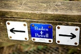
Baden-Powell Trail
Encyclopedia
The Baden-Powell Trail is a rugged but well-maintained trail that traverses Greater Vancouver's
North Shore
region. It was named after Lord Baden-Powell
, founder of the world Scouting Movement.
in West Vancouver
to Deep Cove
in the District of North Vancouver
. In between, the trail winds through the heavily forested North Shore Mountains
. It also connects with several other local trails.
 The trail is well marked with bright orange diamond-shaped tags that are attached to trees alongside the trail. In addition, regular signposts indicate directions and provide distance measurements. A number of stairways and bridges are installed along the trail to make it passable in steep, difficult, or dangerous terrain. However, the trail surface is not completely clear; there are many obstacles such as exposed roots, large rocks, and massive mud puddles. Some sections of the trail are especially steep and can feel somewhat exposed.
(or Knee Knacker) is conducted along the full length of the Baden-Powell Trail.
Highway 1 diverge. On the East end, the trail starts in Panorama Park north from the heart of Deep Cove.
Greater Vancouver
Greater Vancouver is the metropolitan area centred on the city of Vancouver, British Columbia, Canada, roughly coterminous with the Greater Vancouver Regional District, which is governed by a body known as Metro Vancouver...
North Shore
North Shore (Greater Vancouver)
"Vancouver's North Shore" is a term commonly used to refer to several areas adjacent to Vancouver, British Columbia, Canada:*the District of West Vancouver;*the City of North Vancouver;*the District of North Vancouver; and...
region. It was named after Lord Baden-Powell
Robert Baden-Powell, 1st Baron Baden-Powell
Robert Stephenson Smyth Baden-Powell, 1st Baron Baden-Powell, Bt, OM, GCMG, GCVO, KCB , also known as B-P or Lord Baden-Powell, was a lieutenant-general in the British Army, writer, and founder of the Scout Movement....
, founder of the world Scouting Movement.
Geography
The trail is about forty-eight kilometres long, extending (west to east) from Horseshoe BayHorseshoe Bay, West Vancouver, British Columbia
Horseshoe Bay is a West Vancouver community of about 1,000 permanent residents. Situated right on the western tip of West Vancouver, at the entrance to Howe Sound, the village marks the western end of Highway 1 on the British Columbia mainland....
in West Vancouver
West Vancouver, British Columbia
West Vancouver is a district municipality in the province of British Columbia, Canada. A member municipality of Metro Vancouver, the governing body of the Greater Vancouver Regional District, the municipality is northwest of the city of Vancouver on the northern side of English Bay and the...
to Deep Cove
Deep Cove, North Vancouver
Deep Cove refers to both the community in the easternmost part of the District of North Vancouver, in British Columbia, Canada, and also the geographic name of the small bay beside the town. It is affectionately referred to as "The Cove" by local residents. Located at the foot of Mount Seymour,...
in the District of North Vancouver
North Vancouver, British Columbia (district municipality)
The District of North Vancouver is a district municipality in British Columbia and is part of the GVRD. It surrounds the City of North Vancouver on three sides.-Geography:The District of North Vancouver is separated from Vancouver by Burrard Inlet...
. In between, the trail winds through the heavily forested North Shore Mountains
North Shore Mountains
The North Shore Mountains are a mountain range overlooking Vancouver in British Columbia, Canada. Their southernmost peaks are visible from most areas in Vancouver and form a distinctive backdrop for the city....
. It also connects with several other local trails.
Points of interest
There are a number of scenic vistas and points of interest along the way. These include:- the summit of Black Mountain (1217m)
- crossing the Capilano RiverCapilano RiverThe Capilano River flows from north to south through the Coast Mountains on Vancouver's North Shore and empties into Burrard Inlet, opposite Stanley Park. The river is one of three primary sources of drinking water for residents of Greater Vancouver. The Cleveland Dam, built in 1954, impounds a...
by way of the Cleveland DamCleveland DamThe Cleveland Dam is a concrete dam at the head of the Capilano River in North Vancouver, British Columbia, Canada that holds back Capilano Lake. Part of the Capilano River Regional Park, it is not used for generating hydroelectricity, but rather for storing a portion of the Lower Mainland's... - the Grouse Grind, a challenging vertical trail at Grouse Mountain
- the Powerline Trail east of the dam
- the famous Lynn Canyon Suspension BridgeLynn Canyon Suspension BridgeThe Lynn Canyon Suspension Bridge is a pedestrian bridge located within Lynn Canyon Park, in the District of North Vancouver, British Columbia. It is high from the bottom of the canyon. The bridge was built as a private venture in 1912....
- a section along Lynn Creek
- a narrow bridge crossing the Seymour Canyon
- the Quarry Rock lookout in Deep Cove
Identifying the trail
Construction
The trail was constructed in 1971 to celebrate the 100th anniversary of British Columbia's entry into Canada as a province. The project was initiated by the Boy Scouts and Girl Guides organizations of B.C. and much of the work of building it was done by their young members.Events
Every year, an extremely demanding cross-country trail running race known as the Knee Knackering North Shore Trail RunKnee Knackering North Shore Trail Run
The Knee Knackering North Shore Trail Run, also known as the Knee Knacker, was established in 1989 and is a 30-mile ultramarathon trail run in that takes place in British Columbia, in the Greater Vancouver area. Due to its popularity, the field is limited to 200 runners, selected by lottery...
(or Knee Knacker) is conducted along the full length of the Baden-Powell Trail.
Access
The trail has many access points throughout its entirety. On the West end, the trail starts where Highway 99 (Sea-To-Sky) andHighway 1 diverge. On the East end, the trail starts in Panorama Park north from the heart of Deep Cove.