

Ice rise
Encyclopedia
Ice shelf
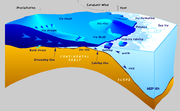
An ice shelf is a thick, floating platform of ice that forms where a glacier or ice sheet flows down to a coastline and onto the ocean surface. Ice shelves are only found in Antarctica, Greenland and Canada. The boundary between the floating ice shelf and the grounded ice that feeds it is called...
, typically dome-shaped and rising 100 to 200 meters above the surrounding ice shelf. An ice rise forms where the ice shelf touches the rocky seabed
Seabed
The seabed is the bottom of the ocean.- Ocean structure :Most of the oceans have a common structure, created by common physical phenomena, mainly from tectonic movement, and sediment from various sources...
because of an elevation in the seabed that remains below sea level. (In contrast, an elevation in the seabed that extends above sea level is defined as an island
Island
An island or isle is any piece of sub-continental land that is surrounded by water. Very small islands such as emergent land features on atolls can be called islets, cays or keys. An island in a river or lake may be called an eyot , or holm...
). The ice shelf flows over the seabed elevation, completely covering it with ice, thereby forming an ice rise. The resulting tension forms crevasse
Crevasse
A crevasse is a deep crack in an ice sheet rhys glacier . Crevasses form as a result of the movement and resulting stress associated with the sheer stress generated when two semi-rigid pieces above a plastic substrate have different rates of movement...
s around the ice rise.
An island within and totally covered by the ice shelf, may appear the exactly the same as an ice rise. Elaborate measurements may be required to distinguish between these two geographic features.
Although ice rises are typically located within the ice shelf area, they can partially face the open sea. Ice rises are found only on the ice shelves of Antarctica, mostly on Ronne Ice Shelf. The largest ice rises exceed dimensions of 50 by 200 km, or 10 000 km² in area. Some ice rises are incorrectly called island
Island
An island or isle is any piece of sub-continental land that is surrounded by water. Very small islands such as emergent land features on atolls can be called islets, cays or keys. An island in a river or lake may be called an eyot , or holm...
s, but also a few totally ice-covered islands within an ice shelf are also called ice rises, most notably Berkner Island
Berkner Island
Berkner Island or Berkner Ice Rise or Hubley Island is a high and completely ice-covered large island about long and wide in Antarctica, with an area of . It is the second largest island of both Antarctica and the British Antarctic Territory, after Alexander Island. It is also located within the...
and Lyddan Island
Lyddan Island
Lyddan Island is an ice-covered island at the southwest extremity of Riiser-Larsen Ice Shelf, separating it from Brunt Ice Shelf, about 20 miles off the Princess Martha Coast. The island is about 45 miles long and has three narrow arms in the form of a trefoil. It was discovered and plotted by W.R...
.
Ice rises, grouped by ice shelf, clockwise starting in East Antarctica
East Antarctica
East Antarctica, also called Greater Antarctica, constitutes the majority of the Antarctic continent, lying on the Indian Ocean side of the Transantarctic Mountains...
:
- Brunt Ice ShelfBrunt Ice ShelfThe Brunt Ice Shelf borders the Antarctic coast of Coats Land between Dawson-Lambton Glacier and Stancomb-Wills Glacier Tongue. It was the location of the base of the Royal Society Expedition, 1955–59 which was taken over as the British Halley Research Station...
- McDonald Ice RumplesMcDonald Ice RumplesThe McDonald Ice Rumples constitute an ice rise on the Brunt Ice Shelf bordering the Weddell Sea in Antarctica. It covers an area of 3 by 2 miles....
- McDonald Ice Rumples
- Shackleton Ice ShelfShackleton Ice ShelfShackleton Ice Shelf is an extensive ice shelf fronting the coast of East Antarctica for about 384 km , projecting seaward about 145 km in the western portion and 64 km in the east. It occupies an area of 33,820 km². It is part of Mawson Sea and separates the Queen Mary Coast to the west from...
- Green Ice RisesGreen Ice RisesGreen Ice Rises is a local swelling of the ice surface 5 nautical miles east of Henderson Island, where the Shackleton Ice Shelf overrides an underlying obstruction. Mapped by G.D. Blodgett from aerial photography taken by U.S. Navy Operation Highjump . Named by Advisory Committee on Antarctic...
(the northernmost ice rise, at 66°21'S) - Harrisson Ice RisesHarrisson Ice RisesHarrisson Ice Rises is a local swelling of the ice surface 12 nautical miles west-southwest of Henderson Island, where the Shackleton Ice Shelf overrides an underlying obstruction. Discovered by the Eastern Sledge Party of the Australasian Antarctic Expedition under Douglas Mawson, who named the...
- Green Ice Rises
- Ross Ice ShelfRoss Ice ShelfThe Ross Ice Shelf is the largest ice shelf of Antarctica . It is several hundred metres thick. The nearly vertical ice front to the open sea is more than 600 km long, and between 15 and 50 metres high above the water surface...
- Crary Ice RiseCrary Ice RiseCrary Ice Rise is an Antarctic ice rise in the south-central part of the Ross Ice Shelf. At 82°56'S, it is the southernmost ice rise. The feature was investigated by the USARP Ross Ice Shelf Project in the 1970s. The name came into use among USARP workers and honors Albert P. Crary , American...
(the southermost ice rise, at 82°56'S)
- Crary Ice Rise
- Crosson Ice ShelfCrosson Ice ShelfCrosson Ice Shelf , is an Antarctic ice shelf, about 35 miles wide, located north and northeast of Mount Murphy along the Walgreen Coast of Marie Byrd Land. The ice shelf is nurtured by Smith, Pope, Vane, and Haynes Glaciers. Mapped by U.S. Geological Survey from surveys and U.S. Navy air photos,...
- Davis Ice RiseDavis Ice RiseDavis Ice Rise is an ice rise, 4 nautical miles long, near the terminus of Smith Glacier, 8 nautical miles southeast of Mayo Peak, Bear Peninsula, on the Walgreen Coast, Marie Byrd Land. Mapped by United States Geological Survey from U.S. Navy aerial photographs taken 1966 and Landsat...
- Davis Ice Rise
- Bach Ice ShelfBach Ice ShelfThe Bach Ice Shelf is an ice shelf which is irregular in shape and in extent, occupying an embayment in the south part of Alexander Island entered between Berlioz Point and Rossini Point. A minor embayment in this position first appeared on the charts of the US Antarctic Service, which explored...
- Burgess Ice RiseBurgess Ice RiseBurgess Ice Rise is a small ice rise in Wilkins Ice Shelf, off the west coast of Alexander Island. It was mapped from the air on a radio echo sounding flight by the British Antarctic Survey on February 11, 1967, and later accurately positioned from U.S. Landsat imagery of February 1979...
- Dvořák Ice RiseDvorak Ice RiseDvorak Ice Rise is an ice rise 1.5 nautical miles in extent, rising above the ice of Mendelssohn Inlet in the southwest part of Alexander Island. First mapped from air photos taken by the Ronne Antarctic Research Expedition , 1947–48, by Searle of the Falkland Islands Dependencies Survey in 1960...
- Ives Ice RiseIves Ice RiseIves Ice Rise is an ice rise about 1 mile long at the head of Weber Inlet, southwest Alexander Island. Mapped by United States Geological Survey from U.S. Navy aerial photographs taken 1967-68 and Landsat imagery taken 1972-73...
- Burgess Ice Rise
- George VI Ice ShelfGeorge VI Ice ShelfThe George VI Ice Shelf is an extensive ice shelf that occupies George VI Sound between Alexander Island and Palmer Land in Antarctica. The ice shelf extends from Ronne Entrance, at the southwest end of the sound, to Niznik Island, about south of the north entrance between Cape Brown and Cape...
- Martin Ice RiseMartin Ice RiseMartin Ice Rise is an ice rise, 6 nautical miles long and 3 nautical miles wide, in George VI Ice Shelf, located 10 nautical miles southwest of Kirwan Inlet, Alexander Island. Delineated as an ice rise from U.S. Landsat imagery of January 1973...
- Martin Ice Rise
- Wilkins Ice Shelf
- Petrie Ice RisesPetrie Ice RisesPetrie Ice Rises is a north-south line of about ten ice rises in Wilkins Ice Shelf, to the west of Alexander Island. Seen from the air on a British Antarctic Survey radio echo sounding flight around Alexander Island, February 11, 1967, and later accurately positioned from U.S. Landsat imagery....
- Schaus Ice RisesSchaus Ice RisesSchaus Ice Rises is a group of small ice rises in Wilkins Ice Shelf, aligned east-west just off the north side of Eroica Peninsula, Alexander Island. Mapped by United States Geological Survey from U.S. Navy aerial photographs taken 1967-68 and from Landsat imagery taken 1972-73. Named by Advisory...
- Vere Ice RiseVere Ice RiseVere Ice Rise is a small ice rise in Wilkins Ice Shelf, off and to the west of Alexander Island. It was roughly mapped from the air by British Antarctic Survey on a radio echo sounding flight on February 1, 1967, and later accurately positioned from U.S. Landsat imagery of February 1979...
- Petrie Ice Rises
- Wordie Ice ShelfWordie Ice ShelfThe Wordie Ice Shelf was a confluent glacier projecting as an ice shelf into the SE part of Marguerite Bay between Cape Berteaux and Mount Edgell, along the western coast of Antarctic Peninsula....
- Coker Ice RiseCoker Ice RiseCoker Ice Rise is a small ice rise in Wordie Ice Shelf, west-northwest of the Triune Peaks, Fallières Coast. It was photographed from the air by the Ronne Antarctic Research Expedition, 1947–48, and surveyed by the Falkland Islands Dependencies Survey, 1958. It was named by the Advisory Committee...
- Linchpin Ice RiseLinchpin Ice RiseLinchpin Ice Rise is a small ice rise northeast of Miller Ice Rise, situated near the ice front of Wordie Ice Shelf on Fallières Coast. The feature was mapped from U.S. Landsat imagery, 1974-79. So named by United Kingdom Antarctic Place-Names Committee because the ice rise plays a key role in...
- Miller Ice RiseMiller Ice RiseMiller Ice Rise is an ice rise nearly 2 nautical miles long and 1 nautical mile wide at the ice front of Wordie Ice Shelf, 16 nautical miles west-northwest of Triune Peaks, in south Marguerite Bay. Surveyed by the Falkland Islands Dependencies Survey , 1948–49, the ice rise was photographed...
- Napier Ice RiseNapier Ice RiseNapier Ice Rise is an ice rise in the southwest portion of Wordie Ice Shelf, western Antarctic Peninsula, 12 nautical miles northwest of Mount Balfour. Surveyed by Falkland Islands Dependencies Survey in November 1958...
- Reynolds Ice RiseReynolds Ice RiseReynolds Ice Rise is a small ice rise lying 3 nautical miles southeast of Wade Ice Rise in Wordie Ice Shelf, Fallières Coast. The ice rise was mapped from U.S. Landsat imagery, 1974-79. Named by the United Kingdom Antarctic Place-Names Committee in 1987 after John M...
- Wade Ice RiseWade Ice RiseWade Ice Rise is a small ice rise in Wordie Ice Shelf, 8 nautical miles northwest of Triune Peaks, Fallières Coast. Photographed from the air by Ronne Antarctic Research Expedition , 1947–48, and surveyed by Falkland Islands Dependencies Survey , 1958. Named in 1977 by Advisory Committee on...
- Coker Ice Rise
- Müller Ice ShelfMuller Ice ShelfMuller Ice Shelf, also known as Müller Ice Shelf according to the original German spelling of the family name Müller, was an ice shelf lying southwest of Hooke Point in southwest Lallemand Fjord, Arrowsmith Peninsula, Loubet Coast...
- Humphreys Ice RiseHumphreys Ice RiseHumphreys Ice Rise is an ice rise in Muller Ice Shelf in the southwest part of Lallemand Fjord, Loubet Coast. Photographed from the air by Falkland Islands and Dependencies Aerial Survey Expedition , 1956–57, and surveyed by Falkland Islands Dependencies Survey , 1956-59...
- Humphreys Ice Rise
- Larsen Ice ShelfLarsen Ice ShelfThe Larsen Ice Shelf is a long, fringing ice shelf in the northwest part of the Weddell Sea, extending along the east coast of Antarctic Peninsula from Cape Longing to the area just southward of Hearst Island...
- Bawden Ice RiseBawden Ice RiseBawden Ice Rise is an ice rise, long and wide, near the edge of the Larsen Ice Shelf, east-southeast of Cape Alexander, Graham Land. The feature, which may consist of more than one ice rise, was mapped on a British Antarctic Survey radio echo sounding flight from Adelaide Island in February...
- Gipps Ice RiseGipps Ice RiseGipps Ice Rise is a roughly elliptical ice rise, 10 nautical miles long and bounded by an ice cliff on all sides, lying at the edge of Larsen Ice Shelf about 35 nautical miles northeast of Hearst Island. The feature was discovered by William R...
- Tharp Ice RiseTharp Ice RiseTharp Ice Rise is an ice rise, about 1.3 nautical miles long, located at the ice front of Larsen Ice Shelf, 15 nautical miles east of Cape Fanning, Merz Peninsula, Black Coast. The ice rise was mapped by United States Geological Survey from U.S. Navy aerial photographs taken 1966-69...
- Bawden Ice Rise
- Ronne Ice Shelf
- Korff Ice RiseKorff Ice RiseKorff Ice Rise is an ice rise, 80 miles long and 20 miles wide, lying 50 miles eastnortheast of Skytrain Ice Rise in the southwest part of Ronne Ice Shelf. It was discovered by the US-IGY Ellsworth Traverse Party, 1957–58, and named by the party for Prof. Serge A. Korff, vice chairman of the...
- Henry Ice RiseHenry Ice RiseHenry Ice Rise is a triangular-shaped ice rise about long located between Korff Ice Rise and the southern portion of Berkner Island in the Ronne Ice Shelf. It was first visited by the US-IGY geophysical traverse party from Ellsworth Station, 1957–58, and named by the Advisory Committee on...
- Fowler Ice RiseFowler Ice RiseFowler Ice Rise is a very large Antarctic ice rise between Evans Ice Stream and Carlson Inlet, in the southwest part of Ronne Ice Shelf. The feature appears to be completely ice covered except for Haag Nunataks, which protrude above the surface in the northwest portion...
- Skytrain Ice RiseSkytrain Ice RiseSkytrain Ice Rise is a large, flattish, peninsula-like ice rise of about 50 miles extent, extending from the vicinity of Meyer Hills in the Heritage Range eastward into the Ronne Ice Shelf...
- Doake Ice RumplesDoake Ice RumplesDoake Ice Rumples is an area of disturbed ice in the Ronne Ice Shelf, extending for about 55 nautical miles in a NW-SE direction between Korff Ice Rise and Henry Ice Rise. First visited and mapped in part by the US-IGY geophysical traverse party from Ellsworth Station 1957-58, led by Edward...
- Dott Ice RiseDott Ice RiseDott Ice Rise is a peninsula-like feature that is ice-drowned except for the Barrett Nunataks, about 20 nautical miles long, extending eastward from the Heritage Range of the Ellsworth Mountains and terminating at Constellation Inlet at the southwest edge of Ronne Ice Shelf. Mapped by United...
- Fletcher Ice RiseFletcher Ice RiseFletcher Ice Rise , or Fletcher Promontory, is a large ice rise, 100 miles long and 40 miles wide, at the southwest side of Ronne Ice Shelf. The feature is completely ice covered and rises between Rutford Ice Stream and Carlson Inlet. The ice rise was observed, photographed and roughly sketched by...
- Hemmen Ice RiseHemmen Ice RiseHemmen Ice Rise is an ice rise 18 km long and 2 to 4 km wide, with an estimated area of 55 km², located 17 km off the northwest corner of Berkner Island in Ronne Ice Shelf. The feature appears for the first time on a chart prepared at Ellsworth Station in 1957 by Captain Finn...
- Kealey Ice RiseKealey Ice RiseKealey Ice Rise is an ice rise, 40 nautical miles long and 15 nautical miles wide, forming a western lobe of the larger Fowler Ice Rise. It is situated just north of the junction of Talutis Inlet and Carlson Inlet, at the southwest side of Ronne Ice Shelf...
- Kershaw Ice RumplesKershaw Ice RumplesKershaw Ice Rumples is a large area of disturbed ice between Fletcher Ice Rise and Korff Ice Rise, in the southwest part of Ronne Ice Shelf. The feature appears in U.S. Navy aerial photographs taken in the 1960s and in imagery obtained by NASA Earth Resources Technology Satellite , 1973-74. Named...
- Korff Ice Rise
Henry and Korff Ice Rises are the largest ice rises, with areas of roughly 1 500 to 1 600 km².