
.gif)
Hurricane Fern (1971)
Encyclopedia
Hurricane Fern was the sixth named storm and fourth hurricane of the 1971 Atlantic hurricane season
. It formed from a tropical wave
which interacted with a large trough
of low pressure to form Fern, as well as Hurricane Ginger
, Tropical Storm Heidi, and a system designated Tropical Depression Eighteen in real-time, then Tropical Depression Sixteen after the fact, which moved into South Carolina
. Fern crossed southeastern Louisiana
as a tropical depression on September 4 before swinging back out over the Gulf of Mexico
. Fern reached hurricane status on September 8, reaching a peak intensity of 90 mph (140 km/h) before making landfall near Freeport, Texas
, two days later.
Fern's path was erratic since it made 90° turns three times during its duration, making it difficult for forecasters to track.
The second Atlantic tropical cyclone
to make U.S. landfall that year, Fern produced heavy rainfall across Louisiana
and Texas
, causing flash flooding that left 2 indirect fatalities and damage totaling over $30 million dollars (1971 USD, $ USD).
on September 1 and became a tropical depression on September 2 after crossing southern Florida
. Still moving northwestward, the tropical depression made landfall in southeastern Louisiana
on September 4. A building high pressure system over the Central United States
forced the tropical depression to move northwest over the Gulf of Mexico
. The warm waters then cause the depression to reach tropical storm strength and the storm was given the name Fern by the National Hurricane Center
on September 7.
The following day, Fern reached hurricane status as it neared the Texas
coastline. The hurricane reached a peak intensity of 90 mph (140 km/h) and its barometric pressure dropped to 979 millibars. An incoming mid-latitude trough caused Fern to stall east of Texas
for twelve hours. After the trough moved by, Fern turned southwest, paralleling the Texas
coastline before making landfall on September 10 between Freeport
and Matagorda
.
At landfall, Fern had weakened to a strong tropical storm as it moved further inland. Because the center of Fern was elongated, it was still able to receive moisture from the Gulf of Mexico
and as a result, weakening was slow. Between September 10 and September 11, Fern bypassed Corpus Christi, Texas
before dissipating as a tropical depression after crossing the Rio Grande River into northern Mexico
.
and it was more threatening to land than Hurricane Edith which was also projected to hit the Gulf Coast. On September 9, as Fern was becoming organized, forecasters issued a hurricane watch along the Texas coast, anticipating that Fern might strengthen into a hurricane. In addition, small boats were warned to stay in port
and residents were advised to be aware of storm conditions brought by Fern. The next day, the hurricane watches were changed to warnings, forcing residents living on the Texas
coast to board up and evacuate. In preparation for the storm's impact, Civil Defense workers and the American Red Cross
were put on alert. In Galveston
, eight emergency shelters were planned to open but five were closed when officials learned that they were not needed as most residents chose to ride out the storm in their homes. When Fern moved inland, the National Weather Service
issued 21 tornado warnings and numerous flood warnings. In North Beach, city buses were used to transport evacuees inland and local officials were concerned about what to do with the relief trailers used to house survivors of Hurricane Celia
a year earlier.
 The precursor disturbance which later became Fern dropped rainfall up to 5 inches (127 mm) of rainfall across South Florida
. Central and Northern Florida received 1 to 3 in (25.4 to 76.2 mm) of rain. In Louisiana
, after making landfall as a tropical depression, Fern produced rainfall up to 10 inches (254 mm) across the southeastern part of the state, including up to 7 inches (177.8 mm) in New Orleans. The outer bands of the tropical depression brought 3 to 5 in (76.2 to 127 mm) of rain across the coastal sections of Mississippi
and Alabama
. There were no reports of damage or fatalities in either Florida
or the eastern U.S. Gulf Coast.
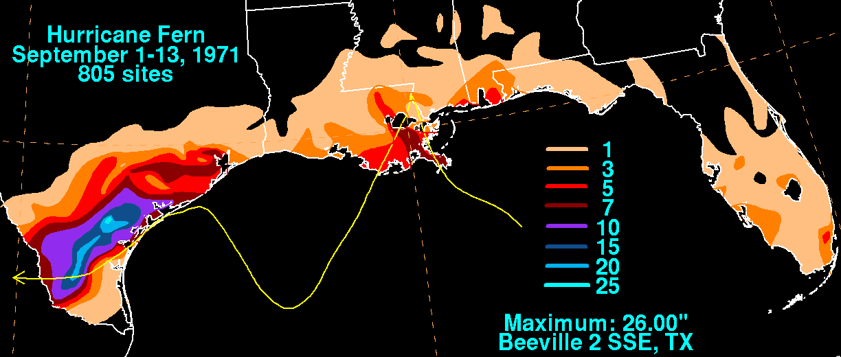
As Fern made its final landfall, a weather station in Port O'Connor, Texas
recorded a sustained wind speed of 86 miles per hour (138.4 km/h). In Corpus Christi
, winds up to 66 miles per hour (106.2 km/h) were reported. In coastal Texas, storm tide
s of 5 to 6 ft (1.5 to 1.8 m) above normal were reported from Galveston
to Freeport
. One spotter reported seeing a flock of swallow
s in the eye of the storm during landfall. Heavy rainfall from the hurricane fell across eastern and central Texas
. A total of 10 to 26 in (254 to 660.4 mm) of rain was measured in a stripe from Bee
to San Patricio County. Other locations in Texas
reported rainfall of 10 to 15 in (254 to 381 mm), while areas from Galveston
to Rockport
received 5 to 12 in (127 to 304.8 mm) of rain. The heavy rainfall caused severe flash flooding that isolated numerous small towns in eastern and central Texas
. An outbreak of five tornadoes was reported during Fern's landfall, two of which caused minor tree and roof damage in Texas City. In addition, lightning from the hurricane caused six reported house fires on Galveston Island
while 7,500 homes and business were damaged (mainly by flooding) near Corpus Christi
. Two indirect fatalities were reported, both from drowning incidents, while on Mustang Island, the hurricane caused four Cuban fishing boats to run aground. In all, the storm left $30.2 million dollars (1971 USD
, $ USD) in damage and two deaths.
1971 Atlantic hurricane season
The 1971 Atlantic hurricane season was fairly active with several notable storms. Hurricane Edith, the strongest of the season, was a Category 5 on the Saffir-Simpson scale, the highest category on the scale. It struck Nicaragua at peak intensity, killing dozens, and later hit southern Louisiana...
. It formed from a tropical wave
Tropical wave
Tropical waves, easterly waves, or tropical easterly waves, also known as African easterly waves in the Atlantic region, are a type of atmospheric trough, an elongated area of relatively low air pressure, oriented north to south, which move from east to west across the tropics causing areas of...
which interacted with a large trough
Trough (meteorology)
A trough is an elongated region of relatively low atmospheric pressure, often associated with fronts.Unlike fronts, there is not a universal symbol for a trough on a weather chart. The weather charts in some countries or regions mark troughs by a line. In the United States, a trough may be marked...
of low pressure to form Fern, as well as Hurricane Ginger
Hurricane Ginger
Hurricane Ginger was the second-longest lasting Atlantic hurricane on record. The eighth tropical cyclone and fifth hurricane of the 1971 Atlantic hurricane season, Ginger spent 27.25 days as a tropical cyclone, lasting from September 6 to October 3...
, Tropical Storm Heidi, and a system designated Tropical Depression Eighteen in real-time, then Tropical Depression Sixteen after the fact, which moved into South Carolina
South Carolina
South Carolina is a state in the Deep South of the United States that borders Georgia to the south, North Carolina to the north, and the Atlantic Ocean to the east. Originally part of the Province of Carolina, the Province of South Carolina was one of the 13 colonies that declared independence...
. Fern crossed southeastern Louisiana
Louisiana
Louisiana is a state located in the southern region of the United States of America. Its capital is Baton Rouge and largest city is New Orleans. Louisiana is the only state in the U.S. with political subdivisions termed parishes, which are local governments equivalent to counties...
as a tropical depression on September 4 before swinging back out over the Gulf of Mexico
Gulf of Mexico
The Gulf of Mexico is a partially landlocked ocean basin largely surrounded by the North American continent and the island of Cuba. It is bounded on the northeast, north and northwest by the Gulf Coast of the United States, on the southwest and south by Mexico, and on the southeast by Cuba. In...
. Fern reached hurricane status on September 8, reaching a peak intensity of 90 mph (140 km/h) before making landfall near Freeport, Texas
Freeport, Texas
Freeport is a city in Brazoria County, Texas within the Houston–Sugar Land–Baytown metropolitan area and is situated in Southeast Texas. As of the 2000 U.S...
, two days later.
Fern's path was erratic since it made 90° turns three times during its duration, making it difficult for forecasters to track.
The second Atlantic tropical cyclone
Tropical cyclone
A tropical cyclone is a storm system characterized by a large low-pressure center and numerous thunderstorms that produce strong winds and heavy rain. Tropical cyclones strengthen when water evaporated from the ocean is released as the saturated air rises, resulting in condensation of water vapor...
to make U.S. landfall that year, Fern produced heavy rainfall across Louisiana
Louisiana
Louisiana is a state located in the southern region of the United States of America. Its capital is Baton Rouge and largest city is New Orleans. Louisiana is the only state in the U.S. with political subdivisions termed parishes, which are local governments equivalent to counties...
and Texas
Texas
Texas is the second largest U.S. state by both area and population, and the largest state by area in the contiguous United States.The name, based on the Caddo word "Tejas" meaning "friends" or "allies", was applied by the Spanish to the Caddo themselves and to the region of their settlement in...
, causing flash flooding that left 2 indirect fatalities and damage totaling over $30 million dollars (1971 USD, $ USD).
Meteorological history
A northwestward moving tropical wave moved out the Caribbean SeaCaribbean Sea
The Caribbean Sea is a sea of the Atlantic Ocean located in the tropics of the Western hemisphere. It is bounded by Mexico and Central America to the west and southwest, to the north by the Greater Antilles, and to the east by the Lesser Antilles....
on September 1 and became a tropical depression on September 2 after crossing southern Florida
Florida
Florida is a state in the southeastern United States, located on the nation's Atlantic and Gulf coasts. It is bordered to the west by the Gulf of Mexico, to the north by Alabama and Georgia and to the east by the Atlantic Ocean. With a population of 18,801,310 as measured by the 2010 census, it...
. Still moving northwestward, the tropical depression made landfall in southeastern Louisiana
Louisiana
Louisiana is a state located in the southern region of the United States of America. Its capital is Baton Rouge and largest city is New Orleans. Louisiana is the only state in the U.S. with political subdivisions termed parishes, which are local governments equivalent to counties...
on September 4. A building high pressure system over the Central United States
Central United States
The Central United States is sometimes conceived as between the Eastern United States and Western United States as part of a three-region model, roughly coincident with the Midwestern United States plus the western and central portions of the Southern United States; the term is also sometimes used...
forced the tropical depression to move northwest over the Gulf of Mexico
Gulf of Mexico
The Gulf of Mexico is a partially landlocked ocean basin largely surrounded by the North American continent and the island of Cuba. It is bounded on the northeast, north and northwest by the Gulf Coast of the United States, on the southwest and south by Mexico, and on the southeast by Cuba. In...
. The warm waters then cause the depression to reach tropical storm strength and the storm was given the name Fern by the National Hurricane Center
National Hurricane Center
The National Hurricane Center , located at Florida International University in Miami, Florida, is the division of the National Weather Service responsible for tracking and predicting weather systems within the tropics between the Prime Meridian and the 140th meridian west poleward to the 30th...
on September 7.
The following day, Fern reached hurricane status as it neared the Texas
Texas
Texas is the second largest U.S. state by both area and population, and the largest state by area in the contiguous United States.The name, based on the Caddo word "Tejas" meaning "friends" or "allies", was applied by the Spanish to the Caddo themselves and to the region of their settlement in...
coastline. The hurricane reached a peak intensity of 90 mph (140 km/h) and its barometric pressure dropped to 979 millibars. An incoming mid-latitude trough caused Fern to stall east of Texas
Texas
Texas is the second largest U.S. state by both area and population, and the largest state by area in the contiguous United States.The name, based on the Caddo word "Tejas" meaning "friends" or "allies", was applied by the Spanish to the Caddo themselves and to the region of their settlement in...
for twelve hours. After the trough moved by, Fern turned southwest, paralleling the Texas
Texas
Texas is the second largest U.S. state by both area and population, and the largest state by area in the contiguous United States.The name, based on the Caddo word "Tejas" meaning "friends" or "allies", was applied by the Spanish to the Caddo themselves and to the region of their settlement in...
coastline before making landfall on September 10 between Freeport
Freeport, Texas
Freeport is a city in Brazoria County, Texas within the Houston–Sugar Land–Baytown metropolitan area and is situated in Southeast Texas. As of the 2000 U.S...
and Matagorda
Matagorda, Texas
Matagorda is an unincorporated community in Matagorda County, Texas, United States. It had a population of approximately 710 in 2000. Matagorda is at the end of State Highway 60 and beginning of Farm to Market Road 2031, which runs over the Intracoastal Waterway and south to the Gulf of Mexico...
.
At landfall, Fern had weakened to a strong tropical storm as it moved further inland. Because the center of Fern was elongated, it was still able to receive moisture from the Gulf of Mexico
Gulf of Mexico
The Gulf of Mexico is a partially landlocked ocean basin largely surrounded by the North American continent and the island of Cuba. It is bounded on the northeast, north and northwest by the Gulf Coast of the United States, on the southwest and south by Mexico, and on the southeast by Cuba. In...
and as a result, weakening was slow. Between September 10 and September 11, Fern bypassed Corpus Christi, Texas
Corpus Christi, Texas
Corpus Christi is a coastal city in the South Texas region of the U.S. state of Texas. The county seat of Nueces County, it also extends into Aransas, Kleberg, and San Patricio counties. The MSA population in 2008 was 416,376. The population was 305,215 at the 2010 census making it the...
before dissipating as a tropical depression after crossing the Rio Grande River into northern Mexico
Mexico
The United Mexican States , commonly known as Mexico , is a federal constitutional republic in North America. It is bordered on the north by the United States; on the south and west by the Pacific Ocean; on the southeast by Guatemala, Belize, and the Caribbean Sea; and on the east by the Gulf of...
.
Preparations
At the time of its formation, forecasters determined that Fern might loop around in the Gulf of MexicoGulf of Mexico
The Gulf of Mexico is a partially landlocked ocean basin largely surrounded by the North American continent and the island of Cuba. It is bounded on the northeast, north and northwest by the Gulf Coast of the United States, on the southwest and south by Mexico, and on the southeast by Cuba. In...
and it was more threatening to land than Hurricane Edith which was also projected to hit the Gulf Coast. On September 9, as Fern was becoming organized, forecasters issued a hurricane watch along the Texas coast, anticipating that Fern might strengthen into a hurricane. In addition, small boats were warned to stay in port
Port
A port is a location on a coast or shore containing one or more harbors where ships can dock and transfer people or cargo to or from land....
and residents were advised to be aware of storm conditions brought by Fern. The next day, the hurricane watches were changed to warnings, forcing residents living on the Texas
Texas
Texas is the second largest U.S. state by both area and population, and the largest state by area in the contiguous United States.The name, based on the Caddo word "Tejas" meaning "friends" or "allies", was applied by the Spanish to the Caddo themselves and to the region of their settlement in...
coast to board up and evacuate. In preparation for the storm's impact, Civil Defense workers and the American Red Cross
American Red Cross
The American Red Cross , also known as the American National Red Cross, is a volunteer-led, humanitarian organization that provides emergency assistance, disaster relief and education inside the United States. It is the designated U.S...
were put on alert. In Galveston
Galveston, Texas
Galveston is a coastal city located on Galveston Island in the U.S. state of Texas. , the city had a total population of 47,743 within an area of...
, eight emergency shelters were planned to open but five were closed when officials learned that they were not needed as most residents chose to ride out the storm in their homes. When Fern moved inland, the National Weather Service
National Weather Service
The National Weather Service , once known as the Weather Bureau, is one of the six scientific agencies that make up the National Oceanic and Atmospheric Administration of the United States government...
issued 21 tornado warnings and numerous flood warnings. In North Beach, city buses were used to transport evacuees inland and local officials were concerned about what to do with the relief trailers used to house survivors of Hurricane Celia
Hurricane Celia
Hurricane Celia was the third named tropical cyclone, the second hurricane, and first major hurricane of the 1970 Atlantic hurricane season. Celia began as a tropical wave which formed off the eastern coast of Africa on July 23. The wave reached the eastern Caribbean Sea on July 28 and began to...
a year earlier.
Impact
Florida
Florida is a state in the southeastern United States, located on the nation's Atlantic and Gulf coasts. It is bordered to the west by the Gulf of Mexico, to the north by Alabama and Georgia and to the east by the Atlantic Ocean. With a population of 18,801,310 as measured by the 2010 census, it...
. Central and Northern Florida received 1 to 3 in (25.4 to 76.2 mm) of rain. In Louisiana
Louisiana
Louisiana is a state located in the southern region of the United States of America. Its capital is Baton Rouge and largest city is New Orleans. Louisiana is the only state in the U.S. with political subdivisions termed parishes, which are local governments equivalent to counties...
, after making landfall as a tropical depression, Fern produced rainfall up to 10 inches (254 mm) across the southeastern part of the state, including up to 7 inches (177.8 mm) in New Orleans. The outer bands of the tropical depression brought 3 to 5 in (76.2 to 127 mm) of rain across the coastal sections of Mississippi
Mississippi
Mississippi is a U.S. state located in the Southern United States. Jackson is the state capital and largest city. The name of the state derives from the Mississippi River, which flows along its western boundary, whose name comes from the Ojibwe word misi-ziibi...
and Alabama
Alabama
Alabama is a state located in the southeastern region of the United States. It is bordered by Tennessee to the north, Georgia to the east, Florida and the Gulf of Mexico to the south, and Mississippi to the west. Alabama ranks 30th in total land area and ranks second in the size of its inland...
. There were no reports of damage or fatalities in either Florida
Florida
Florida is a state in the southeastern United States, located on the nation's Atlantic and Gulf coasts. It is bordered to the west by the Gulf of Mexico, to the north by Alabama and Georgia and to the east by the Atlantic Ocean. With a population of 18,801,310 as measured by the 2010 census, it...
or the eastern U.S. Gulf Coast.
As Fern made its final landfall, a weather station in Port O'Connor, Texas
Port O'Connor, Texas
Port O'Connor is an unincorporated village in Calhoun County, Texas, United States, on the coastline between Galveston and Corpus Christi. The ZIP Code Tabulation Area including Port O'Connor had a population of 1,078 at the 2000 census...
recorded a sustained wind speed of 86 miles per hour (138.4 km/h). In Corpus Christi
Corpus Christi, Texas
Corpus Christi is a coastal city in the South Texas region of the U.S. state of Texas. The county seat of Nueces County, it also extends into Aransas, Kleberg, and San Patricio counties. The MSA population in 2008 was 416,376. The population was 305,215 at the 2010 census making it the...
, winds up to 66 miles per hour (106.2 km/h) were reported. In coastal Texas, storm tide
Storm tide
A storm tide is a tide with a high flood period caused by a storm. Storm tides can be a severe danger to the coast and the people living along the coast. The water level can rise to more than 5 meters above the normal tide....
s of 5 to 6 ft (1.5 to 1.8 m) above normal were reported from Galveston
Galveston, Texas
Galveston is a coastal city located on Galveston Island in the U.S. state of Texas. , the city had a total population of 47,743 within an area of...
to Freeport
Freeport, Texas
Freeport is a city in Brazoria County, Texas within the Houston–Sugar Land–Baytown metropolitan area and is situated in Southeast Texas. As of the 2000 U.S...
. One spotter reported seeing a flock of swallow
Swallow
The swallows and martins are a group of passerine birds in the family Hirundinidae which are characterised by their adaptation to aerial feeding...
s in the eye of the storm during landfall. Heavy rainfall from the hurricane fell across eastern and central Texas
Texas
Texas is the second largest U.S. state by both area and population, and the largest state by area in the contiguous United States.The name, based on the Caddo word "Tejas" meaning "friends" or "allies", was applied by the Spanish to the Caddo themselves and to the region of their settlement in...
. A total of 10 to 26 in (254 to 660.4 mm) of rain was measured in a stripe from Bee
Bee County, Texas
Bee County is a county located in the U.S. state of Texas. Bee County was founded December 8, 1857. As of 2010, the population was 31,861. Its county seat is Beeville. Bee County is named for Barnard E...
to San Patricio County. Other locations in Texas
Texas
Texas is the second largest U.S. state by both area and population, and the largest state by area in the contiguous United States.The name, based on the Caddo word "Tejas" meaning "friends" or "allies", was applied by the Spanish to the Caddo themselves and to the region of their settlement in...
reported rainfall of 10 to 15 in (254 to 381 mm), while areas from Galveston
Galveston, Texas
Galveston is a coastal city located on Galveston Island in the U.S. state of Texas. , the city had a total population of 47,743 within an area of...
to Rockport
Rockport, Texas
Rockport is a city in Aransas County, Texas, United States. The population was 7,385 at the 2000 census. It is the county seat of Aransas County. The coastal community has approximately 8000 citizens. Large windswept live oaks are a dominating feature of the area and the state's oldest live oak,...
received 5 to 12 in (127 to 304.8 mm) of rain. The heavy rainfall caused severe flash flooding that isolated numerous small towns in eastern and central Texas
Texas
Texas is the second largest U.S. state by both area and population, and the largest state by area in the contiguous United States.The name, based on the Caddo word "Tejas" meaning "friends" or "allies", was applied by the Spanish to the Caddo themselves and to the region of their settlement in...
. An outbreak of five tornadoes was reported during Fern's landfall, two of which caused minor tree and roof damage in Texas City. In addition, lightning from the hurricane caused six reported house fires on Galveston Island
Galveston Island
Galveston Island is a barrier island on the Texas Gulf coast in the United States, about 50 miles southeast of Houston. The entire island, with the exception of Jamaica Beach, is within the city limits of the City of Galveston....
while 7,500 homes and business were damaged (mainly by flooding) near Corpus Christi
Corpus Christi, Texas
Corpus Christi is a coastal city in the South Texas region of the U.S. state of Texas. The county seat of Nueces County, it also extends into Aransas, Kleberg, and San Patricio counties. The MSA population in 2008 was 416,376. The population was 305,215 at the 2010 census making it the...
. Two indirect fatalities were reported, both from drowning incidents, while on Mustang Island, the hurricane caused four Cuban fishing boats to run aground. In all, the storm left $30.2 million dollars (1971 USD
United States dollar
The United States dollar , also referred to as the American dollar, is the official currency of the United States of America. It is divided into 100 smaller units called cents or pennies....
, $ USD) in damage and two deaths.
See also
- Tropical cycloneTropical cycloneA tropical cyclone is a storm system characterized by a large low-pressure center and numerous thunderstorms that produce strong winds and heavy rain. Tropical cyclones strengthen when water evaporated from the ocean is released as the saturated air rises, resulting in condensation of water vapor...
- List of wettest tropical cyclones in Texas